City of Nedlands
| City of Nedlands Western Australia | |||||||||||||
|---|---|---|---|---|---|---|---|---|---|---|---|---|---|
 | |||||||||||||
| Population | 22,918 (2013 est)[1] | ||||||||||||
| • Density | 1,150/km2 (3,000/sq mi) | ||||||||||||
| Established | 1893 | ||||||||||||
| Area | 20 km2 (7.7 sq mi) | ||||||||||||
| Mayor | Max Hipkins | ||||||||||||
| Council seat | Nedlands | ||||||||||||
| Region | West Metropolitan Perth | ||||||||||||
| State electorate(s) | Nedlands, Cottesloe | ||||||||||||
| Federal Division(s) | Curtin | ||||||||||||
|
| |||||||||||||
| Website | City of Nedlands | ||||||||||||
| |||||||||||||
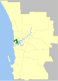
The City of Nedlands is a local government area in the inner western suburbs of the Western Australian capital city of Perth, about 7 kilometres (4 mi) west of Perth's central business district. The City covers an area of 20.0 square kilometres (7.7 sq mi), maintains 137 km of roads and a little over 380 hectares (939 acres) of parks and gardens, and has a population of over 21,000 as of 2016.
History
The City of Nedlands had its origins in the Claremont Road District, which was created in 1893 after a petition from ratepayers who lived in the areas of Nedlands and Claremont, which had grown substantially in population at the end of the 19th century. Seven men were nominated to the new Board, which became the first local government authority for the Nedlands/Claremont area. In 1898, Claremont itself split away to form a municipal government, which still exists today as the Town of Claremont.
In 1932, the Claremont Road Board was renamed Nedlands, and on 1 July 1959, it became a city. The City was made up of four wards – Melvista, Hollywood, Dalkeith and Coastal. These wards continue to the present day.
Wards
The town is divided into four wards, each electing three councillors. The mayor is directly elected.
- Coastal Ward
- Dalkeith Ward
- Hollywood Ward
- Melvista Ward
Suburbs
* Shared with other council areas (Subiaco; Cambridge)
Population
| Year | Population |
|---|---|
| 1911 | 1,230 |
| 1921 | 3,557 |
| 1933 | 10,580 |
| 1947 | 18,226 |
| 1954 | 22,814 |
| 1961 | 23,218 |
| 1966 | 23,320 |
| 1971 | 22,878 |
| 1976 | 20,974 |
| 1981 | 20,257 |
| 1986 | 18,623 |
| 1991 | 20,210 |
| 1996 | 20,598 |
| 2001 | 21,047 |
| 2006 | 20,334 |
| 2011 | 20,534 |
References
- ↑ "3218.0 Regional Population Growth, Australia. Table 5. Estimated Resident Population, Local Government Areas, Western Australia". 3 April 2014. Retrieved 11 September 2014.
External links
Coordinates: 31°58′55″S 115°48′25″E / 31.982°S 115.807°E