Stoke Newington
| Stoke Newington | |
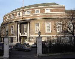 Stoke Newington Town Hall, built 1935–37 for the Metropolitan Borough of Stoke Newington |
|
 Stoke Newington |
|
| OS grid reference | TQ335865 |
|---|---|
| – Charing Cross | 5 mi (8.0 km) SW |
| London borough | Hackney |
| Ceremonial county | Greater London |
| Region | London |
| Country | England |
| Sovereign state | United Kingdom |
| Post town | LONDON |
| Postcode district | N16 |
| Dialling code | 020 |
| Police | Metropolitan |
| Fire | London |
| Ambulance | London |
| EU Parliament | London |
| UK Parliament | Hackney North and Stoke Newington |
| London Assembly | North East |
Coordinates: 51°33′41″N 0°04′23″W / 51.5615°N 0.0731°W
Stoke Newington is an area occupying the north-west part of the London Borough of Hackney.
The historic core on Church Street was the site of the original hamlet of Stoke Newington which in turn gave its name to the Ancient Parish of Stoke Newington. Church Street retains the distinct London village character which led Nikolaus Pevsner to write that he found it hard to see the district as being in London at all.[1]
Stoke Newington is nicknamed "Stokey" by many residents.[2][3]
Boundaries

The modern London Borough of Hackney was formed by the merger of three former Metropolitan Boroughs; Hackney and the considerably smaller authorities of Stoke Newington and Shoreditch. These Metropolitan Boroughs had been in existence since 1899 but their names and boundaries were very closely based on much older ancient parishes dating back to the medieval period.
Unlike many districts in London, such as nearby Stamford Hill and Dalston within the former AP\MB (Ancient Parish\Metropolitan Borough) of Hackney, Stoke Newington has longstanding formal boundaries; but like many areas the area definition has changed over time and Stoke Newington is now popularly regarded as stretching further east to overlap areas of the former AP\MB of Hackney.
Formal historic boundaries
As described the Metropolitan Borough largely adopted the Ancient Parishes boundaries, including the parts of the eastern boundary which followed the originally Roman A10 road. There were minor rationalisations but the major change to the area covered was the transfer of part of Hornsey (South Hornsey).
Stoke Newington northern and western boundaries have become the north-west borders of the modern London Borough. The eastern boundary was formed primarily by the A10 road where it goes by the name Stoke Newington High St (near the core) and Stoke Newington Road (meaning the road to the hamlet of Stoke Newington), further south.
The exceptions to this are areas where Hackney extended west of the A10:
- Where that part of AP\MB of Hackney known as Stamford Hill meets Stoke Newington on a line running along Bethune Road and the railway.
- Where that part of AP\MB of Hackney known as Dalston extends a short way over the A10 to meet Stoke Newington on a line along a road called ‘The Crossway’.
This boundary included the sites of the small hamlet of Stoke Newington and part of Newington Green, however it excluded Stoke Newington railway station, the open space known since the early twentieth century as Stoke Newington Common (originally Cockhangar Common) and Stoke Newington High Street formed a boundary rather than an integral part.
Wider, informal modern extent
Today, Stoke Newington is considered to cover a wider area, extending eastward from Stoke Newington High Street to include Stoke Newington railway station, Rectory Road railway station and Stoke Newington Common but lacking formal or popularly recognized boundaries in this direction.
The growth means that Stoke Newington is often (like nearby Stamford Hill) associated with the N16 postcode, though a significant part of western Stoke Newington is covered by the N4 postcode district.
Stoke Newington is part of the Hackney North and Stoke Newington constituency which has been represented by Labour MP Diane Abbott since 1987.
Open space
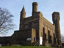
For a small district, Stoke Newington is endowed with a generous amount of open space. To its north, there is the extensive West Reservoir, now a non-working facility, but open for leisure and surrounded by greenspace, at the entrance to which is the architecturally bizarre Castle Climbing Centre, once the main Water Board pumping station. It was designed, by William Chadwell Mylne, to look like a towering Scottish castle.
South of these facilities is Clissold Park, an extensive swathe of parkland complete with a small menagerie, aviary and Clissold Mansion, a Grade II listed building, built for Jonathan Hoare, a local Quaker and brother of Samuel Hoare, in the 1790s.[4]
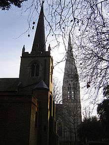
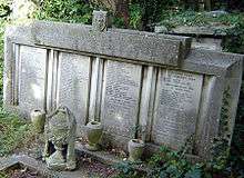
Tracking east from here and past the two Church of England parish churches, both called St Mary's (Stoke Newington decided to retain the old one, unusual in a London parish), leads to Abney Park Cemetery, one of the most splendid and enlightened of Victorian London cemeteries. It is now a nature reserve, a role that it was in many ways intended for, as it was set up as an arboretum. Abney Park became scheduled in 2009 as one of Britain's historic parks and gardens at risk from neglect and decay.[5] Finally, across the high street to the east is the fragmented Stoke Newington Common, which has had an extensive and diverse programme of tree planting.
Reservoirs
From the 16th century onwards, Stoke Newington has played a prominent role in assuring a water supply to sustain London's rapid growth. Hugh Myddleton's New River runs through the area and still makes a contribution to London's water. It used to terminate at the New River Head in Finsbury, but since 1946 its main flow has ended at Stoke Newington reservoirs. A slow ornamental trickle flows past the West Reservoir, goes underground for a stretch on Green Lanes, reappears for a time in Clissold Park, and disappears underground again on its way to Canonbury. The river bank, the New River Path,[6] can be walked for some distance to the north through Haringey and on to its source near Hertford, though not all sections are open.
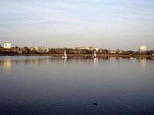
Stoke Newington East and West Reservoirs, to the north of Clissold Park, are quite substantial for urban facilities. Stoke Newington Reservoirs were constructed in 1833 to purify the New River water and to act as a water reserve. The West Reservoir is now a leisure facility, offering sailing, canoeing and other water sports, plus Royal Yachting Association-approved sailing courses. On its western edge stands the former filter house, now set out as a visitor centre with a café; some of the old hydraulic machinery can be viewed in the main hall. The pumping station at the reservoir gates, converted to a climbing centre in 1995 was designed in a distinctive castellated style by Robert Billings under the supervision of William Chadwell Mylne and built in 1854–56.[7]
Besides the water board facilities and the New River, Clissold Park contains two large ornamental lakes, a home to many water birds and a population of terrapins. These lakes – purportedly the remains of clay pits dug for the bricks used in the building of Clissold House – are all that is left to mark the course of the Hackney Brook, one of London's lost rivers, which once flowed from west to east across Stoke Newington on its way to the River Lea. In flood at this point, the brook was known to span 10 metres. The two lakes are not fed from the brook, which has disappeared into the maze of sewers under London, but from the mains supply – the New River.
History
Early
Stoke Newington or 'new town in the wood', has been lightly settled for hundreds of years, close to larger neighbouring Saxon settlements near the River Lea. In the 19th century it was discovered that Stoke Newington Common and Abney Park Cemetery had been part of a Neolithic working area for axe-making, some examples of which can be seen in the Museum of London.
Stoke Newington is recorded as part of the Ossulstone hundred in the county of Middlesex in the Domesday Book of 1086. In the 17th century, for administrative purposes the west of Stoke Newington High Street became part of the new Finsbury division and the east part of the Tower division. Both divisions were in 1889 then incorporated into the County of London.
In the Middle Ages and Tudor times, it was a very small village a few miles from the city of London, frequently visited by wayfarers as a pit stop before journeying north, Stoke Newington High Street being part of the Cambridge road (A10). At this date the whole manor was owned by St. Paul's Cathedral and yielded a small income, enough to support part of their work. During the 17th century the Cathedral sold the Manor to William Patten, who became the first Lord of the Manor. His initials 'WP' and the motto 'ab alto' can be seen inscribed above the doorway of the old church next to Clissold Park.
18th century
A century later, it passed to Lady Mary Abney who drew up the first detailed maps of field boundaries and began to lay out a manorial parkland behind today's fire station on Church Street, with the aid of her daughters and Dr Isaac Watts.
19th century
During the early 19th century, as London expanded, the Manor of Stoke Newington was 'enfranchised' to be sold in parcels as freehold land for building purposes. Gradually the village became absorbed into the seamless expansion of London. It was no longer a separate village by the mid-to-late 19th century.
Being on the outskirts at this time, many expensive and large houses were built to house London's expanding population of nouveau riche whose journey to the commercial heart of the capital was made possible by the birth of the railways and the first omnibuses. The latter were first introduced into central London in the 1820s by George Shillibeer, following his successful trial of the world's first school bus for William Allen and Susannah Corder's novel Quaker school, Newington Academy for Girls. By the mid-19th century, Stoke Newington had "the largest concentration of Quakers in London", including many who had moved up the A10 from Gracechurch Street meeting house in the City. A meeting house was built in Park Street (now Yoakley Road) by the architect William Alderson, who later designed Hanwell Lunatic Asylum.[8]
St Mary's Lodge on Lordship Road, the 1843 home of architect and district surveyor John Young, is the last-surviving of several grand detached houses built in the area around that time for well-off members of the new commuter class. Gibson Gardens, an early example of quality tenement buildings erected for the housing of 'the industrious classes', were built off Stoke Newington High Street in 1880 and still stand today.
As a late Victorian and Edwardian suburb, Stoke Newington prospered, and continued in relative affluence and civic pride with its own municipal government until changes brought about by the Second World War.
Early 20th century
Between 1935–37, the curved brick and Portland Stone Town Hall was built for the Metropolitan Borough of Stoke Newington by J. Reginald Truelove.[9]
Second World War
During World War II, much of the area was damaged in the Blitz and many were made homeless, although the level of destruction was much lower than in those areas of East London further south such as Stepney or Shoreditch or even in next-door Hackney. The death toll was also relatively low: almost three-quarters of civilian deaths being due to one incident on 13 October 1940 when a crowded shelter at Coronation Avenue off the high street received a direct hit. The memorial to all the residents of the Borough who died in the air raids, including local Jewish people, can be seen in Abney Park Cemetery. Like Hackney and Tottenham, Stoke Newington avoided most of the later V-weapon attacks, which fell disproportionately on South London; seven V-1s and two V-2s hit the borough.
Most of the historic buildings at the heart of Stoke Newington survived, at least in a repairable state. Two notable exceptions are the classically grand parish church of West Hackney, St James's, on Stoke Newington Road, which dated from 1824, and St Faith's, a Victorian Gothic church by William Burges. Both were so severely damaged, the former in the October 1940 bombing, and the latter by a flying bomb in 1944, that they were entirely demolished. St James's was replaced after the war by a much more modest structure, St Paul's, which is set well back from the street. Traces of the old church's stonework can still be seen facing Stoke Newington Road.
Postwar developments
After the war a substantial amount of residential housing, particularly to the east of modern Stoke Newington, in Hackney borough at the time, had been either destroyed or left in such a bad state that it was seen by the urban planners of that era as better to demolish it. Postwar redevelopment has replaced many of these areas with large estates, some more successful than others. Much of this residential redevelopment was planned by Frederick Gibberd, the designer of Liverpool Metropolitan Cathedral.
Political radicalism and terrorism
Ever a home to radicals, Communist Party meetings were held in the Town Hall in the post-war years. And although Stoke Newington became part of the London Borough of Hackney in 1965, it has never quite lost its own identity. Indeed, following the 1960s, it increasingly became home to a number of squatters, artists, bohemians and also political radicals. Famously, the 'Stoke Newington 8' were arrested on 20 August 1971 at 359 Amhurst Road for suspected involvement in The Angry Brigade bombings.
The most famous examples of political terrorism by Stoke Newington residents, none originally from the area, are Patrick Hayes, Jan Taylor and Muktar Said Ibrahim. The first two were convicted of two bombings and had substantial links to the huge lorry bombs of the 1990s. Both were arrested, firing at officers in Walford Road and later sentenced to thirty years imprisonment.
The third, Muktar Said Ibrahim, was convicted, as the ring leader, on an indictment of conspiracy to murder. He planted a failed bomb on a 26 bus, which misfired later on the Hackney Road on 21 July 2005. Ibrahim used to work at an off-licence on Amhurst Road. In February 2005, police were seeking Ibrahim on an arrest warrant for an outstanding public order offence and sent a letter to his Farleigh Road address saying "Call us, before we call you." After the attack, Ibrahim was seen on the run in Farleigh Road and was later arrested in Dalgrano Gardens, W10. He was sentenced to life imprisonment, to serve a minimum of forty years before being considered for release.
21st century
These days, Stoke Newington is a very multicultural area, with large Asian, Irish, Turkish, Jewish and Afro-Caribbean communities. The area continues to be home to many new and emerging communities such as Polish and Somali immigrants.
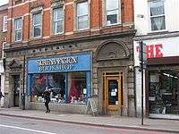
Stoke Newington has undergone major gentrification, as have neighbouring Newington Green, Canonbury and Dalston. Much of the gentrification of the area has been based around Church Street, where there are many independent shops, pubs, bars and cafes.[10]
On Saturday mornings, St Paul's churchyard in Stoke Newington High Street hosts an active farmers' market – relocated in July/August 2011 from its earlier site in the playground of William Patten Primary school on Church Street. This was the first farmers' market in the UK to have only organic and biodynamic producers.
In June 2011 property developer Newmark Properties LLP announced their proposed development for Wilmer Place. This includes a large Sainsburys supermarket, "high quality private and affordable residential apartments", and a car park for over 90 vehicles. This development requires the demolition of some of the existing properties in Wilmer Place and 195–201 Stoke Newington High Street. There has been strong local reaction against this development during the brief pre-planning consultation. Several local groups are protesting against this development, including Hackney Unites, the Hackney Liberal Democrat Party, and Stokey Local, a group formed by local business leaders and residents.
Demography
As of the 2011 census in the Stoke Newington Central ward, 60% of the population was white (41% British, 16% Other, 3% Irish). 18% was Black (8% Caribbean, 7% African, 3% Other).[11]
Education

- For details of education in Stoke Newington see the Hackney article
Primary schools
- Benthal Primary
- Betty Layward Primary
- Grasmere Primary
- Grazebrook Primary
- Holmleigh Primary
- Princess May Primary
- Jubilee Primary
- Simon Marks Jewish Primary School
- Sir Thomas Abney
- Saint Mary's Church of England Primary
- Saint Matthias Church of England Primary
- William Patten Primary.
Secondary schools
Defunct schools
- Newington Academy for Girls, a Quaker school established 1824 by William Allen
- Fleetwood Primary School
- Palatine School, Palatine Road.
- William Wordsworth Secondary School, Wordsworth Road (but official address Palatine Road). This was the old Palatine School.
- Daniel Defoe Secondary School, Ayresome Road. William Wordsworth Secondary School merged with Daniel Defoe Secondary School in 1965 to become Clissold Park School. Both buildings were used until a new school building was building in Clissold Road. The school merged with Woodberry Down Comprehensive to become Stoke Newington School.
Architecture
Although Stoke Newington contains only one Grade I listed building (St Matthias Church), it contains a fair number of Grade II* buildings for one London district. Residential buildings are strongly represented, and this becomes even more clear when the lowest grade, Grade II, is considered, where almost whole streets are listed in some cases.[12]
- Grade I
- St Matthias Church, Wordsworth Road
- Grade II*
- 187–191 Stoke Newington High Street
- 81/83 Stoke Newington Church Street
- 85/87 Stoke Newington Church Street
- St Mary's Old Church
- St Mary's New Church
- Clissold House, Clissold Park
- St Andrew's Church, Bethune Road
- The Castle Climbing Centre, Green Lanes
- Grade II
- Stoke Newington Town Hall (restoration in 2010 won the Wood Awards)[13] and Library
- Abney Park Chapel
- Newington Green Unitarian Church
- 113 Stoke Newington Church Street, one time residence of the poet and writer Anna Laetitia Barbauld
- Sanford Terrace
There are many Grade II listed properties on Stoke Newington Church Street, the historical heart of the district, and two other notable residential streets to the west of the district – Albion Road and Clissold Road – are replete with listed properties.
Close to the local pub The Lion, local resident and property owner Sofie Attrill gave consent for pop group Blur to create some publicity for their 2003 single "Crazy Beat". The album's cover and single artwork were undertaken by graffiti artist Banksy, with the single featuring a spoof image of the British Royal Family, replicated as a mural on the building. By 2009 it had become a tourist attraction, but Hackney Council had wanted to remove all graffiti from the area and tried to contact the building owner to gain her agreement to remove the artwork. Unable to contact her due to incorrect Land Registry records, they started painting over the artwork with black paint. They were stopped after they had partly covered the mural.[14]
Transport and locale
 |
Manor House | Stamford Hill | Upper Clapton | |
| Finsbury Park | |
Upper Clapton | ||
| ||||
| | ||||
| Newington Green | Dalston | Lower Clapton |

About 1.5 miles (2.4 km) away, the nearest London Underground station is Manor House on the Piccadilly line.
- Lea Valley Lines (south to north) — from London Liverpool Street
It is served by bus routes 67, 73, 76, 106, 149, 243, 276, 393 and 476 and Night Buses N73 and N76. 149 and 243 are 24-hour services.
Entertainment
Stoke Newington is well known for its pubs and bars, lively music scene, including contemporary jazz, and open mic comedy sessions. The Vortex Jazz Club used to be on Church Street but has now moved to Dalston.
Since 2010, Stoke Newington has also had its own literary festival, created to celebrate the area's literary and radical history. It takes place in early June in venues across the area and was described in 2011 by Time Out magazine as 'Just like Hay-on-Wye, but in Hackney', by The Times as one of its 'Top 5 Summer of Books' and by Londonist.com as 'a literary festival that's thrown its pretensions in a skip'.
People associated with Stoke Newington
Historic
- Lady Mary Abney (1676–1750), inherited the manor and commissioned the first map-based survey.
- William Allen (1770–1843), Quaker, philanthropist, scientist, abolitionist, and pioneer of girls' education – lived most of his life in Stoke Newington.
- Anna Laetitia Barbauld (1743–1825), writer and poet, lived at 113 Stoke Newington Church Street.
- Wynne Edwin Baxter (1844–1920), coroner for several of the Jack the Ripper murders of 1888, died at his home in Church Street in 1920.
- Eric Bristow (born 1957), five times world professional darts champion, born in Stoke Newington.
- Joseph Conrad (1857–1924), author of Heart of Darkness – lived in Stoke Newington.
- Sir Horace Cutler (1912–1997), politician – born in the district.
- John Diamond (1953–2001), journalist and radio presenter – born in Stoke Newington.
- Daniel Defoe (c. 1660 – 1731), writer – born and lived on Church Street. His gravestone can be seen in the Hackney Museum.
- Charles Fleetwood (1618–1692), Parliamentary General during the English Civil War, later Lord Deputy of Ireland and Commander-in-Chief of the armed forces lived in Stoke Newington.
- John Young (architect) (1797-1877), a Suffolk man who settled in the area and moved in lofty professional circles, but retained his link with the earth through highly creative brickwork.
- Paul Foot (1937–2004), political activist and writer – born in Palestine, lived in Stoke Newington.
- Joseph Jackson Fuller (1825–1908), Jamaican missionary to pre-colonial West Africa
- Samuel Hoare (1751–1825), Quaker and abolitionist lived in Paradise Row, Stoke Newington.
- John Howard (1726–1790), founding father of the prison reform movement, lived in Stoke Newington.
- Hugh Gater Jenkins, Baron Jenkins of Putney (1908–2004), representative 1958–1965 of the Stoke Newington & Hackney constituency on the London County Council.
- Michael Levy, Baron Levy (born 1944), impresario and political fund raiser – born in Stoke Newington.
- Bernard Lewis (born 1916), historian of Islam and the Middle East, born in Stoke Newington.
- Joseph Jackson Lister (1786–1869), Quaker, amateur opticist and physicist, inventor of the modern microscope and the father of Joseph Lister; spent his early married life in Stoke Newington.
- Ken Livingstone (born 1945), former Mayor of London, was the representative for Stoke Newington on the Greater London Council between 1977 and 1981.
- Thomas Manton (1620–1677), appointed minister of St Mary's Church 1644/5; a forthright defender of Reformed principles and one of Oliver Cromwell's chaplains
- Samuel Morley MP (1809–1886), businessman, statesman, philanthropist and abolitionist – lived in Stoke Newington.
- James Richardson Spensley (1867–1915), doctor, Genoa CFC footballer, manager, Scout Leader and medic was born in 1867 in Stoke Newington.
- James Stephen (1758–1832), slavery abolitionist – his father moved the family home to Stoke Newington in 1774.
- Edgar Allan Poe (1809–1849), writer – attended Manor School on Church Street around 1820.
- Isaac Watts (1674–1748), theologian, logician and hymnwriter – lived and died at Abney House.
- Joseph Woods (1776–1864), Quaker, botanist and architect, son of a founding abolitionist by the same name.
20th and 21st centuries
- Marc Bolan (born, Mark Feld), musician – lived on Stoke Newington Common until age 15
- Bad Manners come from Stoke Newington. The band were formed at Woodberry Down comprehensive school in 1976.
- 1980s pop star Buster Bloodvessel lived on Batley Road.
- Mark 'Bedders' Bedford, bass player with Madness – lives in Stoke Newington.
- Violet Berlin, television presenter – lives in Stoke Newington with partner Gareth 'Gaz Top' Jones.
- Asa Butterfield, child actor, goes to Stoke Newington Middle School, lives in Islington.
- Clem Cattini, musician – born in Stoke Newington.
- Richard Bebb, actor, theatre historian, music archivist – lived in St Mary's Lodge, Lordship Road, as a child
- Elton Dean, experimental jazz saxophonist from Bluesology lived in Stoke Newington
- DJ Dextrous, Ivor Novello & BAFTA awards winning Producer/DJ – born in Stoke Newington
- Rupert Evans, film and theatre actor, lives in Stoke Newington
- Paloma Faith, singer and actress, raised in Stoke Newington
- Reginald Fox, actor
- Jonathan Freedland, journalist and author – lives in Stoke Newington
- Gareth Jones, aka Gaz Top, TV presenter and producer – lives in Stoke Newington.
- Stewart Lee, comedian and writer – lives in Stoke Newington
- Zöe Lucker, actress in Holbyblue & Footballers Wives lives in Stoke Newington.
- Malcolm McLaren - manager of The Sex Pistols
- Warren Mitchell, actor – born in the district.
- Kevin MacNeil, Hebridean-born novelist, poet and playwright, lives in Stoke Newington.
- Thurston Moore, musician - lives in Stoke Newington.
- David O'Leary, football manager and Arsenal FC appearance record holder – born in Stoke Newington.
- Alexei Sayle, comedian – wrote a famous stand up sketch about Stoke Newington.
- Tjinder Singh, lead singer of Cornershop, lives in Stoke Newington.
- Chris Singleton, the Irish singer-songwriter, lives in Stoke Newington; his 'Twisted City' album cover features a girl walking in Abney Park Cemetery.
- Barbara Windsor, actress in EastEnders & the Carry On films – born in Shoreditch but grew up around Amhurst Road and lived in Yoakley Road.
- Fyfe Dangerfield, lead singer of Guillemots lives in Stoke Newington
- Andrew Ranken, drummer in The Pogues
- Maverick Sabre, singer-songwriter, was born in Stoke Newington.
- Ronan Bennett, writer of BBC Drama's Hidden and C4's Top Boy, born in Ireland, lives in Stoke Newington.
- Jean Marsh, actress and writer, was born in Stoke Newington.
- Labrinth, singer, went to Stoke Newington School
- Nick Grimshaw, Radio and Television personality lives in Stoke Newington.
References
- ↑ The Buildings of London; 1953 "Stoke Newington is not entirely London yet"
- ↑ "Petition against Stokie Sainsbury's launched". EastLondonLines. Retrieved 28 March 2013.
- ↑ "Live and work in Stoke Newington". TNT Magazine. 19 September 2011. Retrieved 28 March 2013.
- ↑ Clissold Park users group accessed 26 March 2007
- ↑ English Heritage's 'At Risk' register accessed 5 July 2010
- ↑ http://www.thameswateruk.co.uk/en_gb/Downloads/PDFs/PBS_New_River_Path_-_a_walk_linking_Hertford_with_Islington_714kb.pdf thameswateruk.co.uk
- ↑ Bridget Cherry and Nikolaus Pevsner, London 4: North, London, Penguin, 1999, p. 540
- ↑ "Quakers around Shoreditch". studymore.org.uk.
- ↑ Architect and Building News, 8 October 1937, pp. 39 -43
- ↑ http://classsystem.blogspot.co.uk/2011/12/gentrification.html.
- ↑ http://www.ukcensusdata.com/stoke-newington-central-e05000247
- ↑ Hackney council listed buildings
- ↑ "Stoke Newington Town Hall". The Wood Awards. Retrieved 23 April 2012.
- ↑ "Blur Banksy is ruined by mistake". BBC News. 4 September 2009. Retrieved 4 September 2009.
External links
| Wikimedia Commons has media related to Stoke Newington. |
 "Stoke Newington". Encyclopædia Britannica. 25 (11th ed.). 1911.
- Time Out Stoke Newington area guide
| Districts |  | |
|---|---|---|
| Attractions | ||
| Parks and open spaces | ||
| Street markets | ||
| Constituencies | ||
| Tube and rail stations | ||
| Other topics | ||
| Section 12: | Capital Ring Walking Route | Section 13: |
|---|---|---|
| Highgate | Stoke Newington | Hackney Wick |