Taos County, New Mexico
| Taos County, New Mexico | ||
|---|---|---|
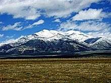 Taos Mountain from El Prado | ||
| ||
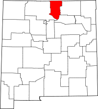 Location in the U.S. state of New Mexico | ||
 New Mexico's location in the U.S. | ||
| Founded | January 9, 1852 | |
| Seat | Taos | |
| Largest town | Taos | |
| Area | ||
| • Total | 2,204 sq mi (5,708 km2) | |
| • Land | 2,203 sq mi (5,706 km2) | |
| • Water | 1.3 sq mi (3 km2), 0.06% | |
| Population (est.) | ||
| • (2015) | 32,907 | |
| • Density | 15/sq mi (6/km²) | |
| Congressional district | 3rd | |
| Time zone | Mountain: UTC-7/-6 | |
| Website |
www | |

Taos County is a county located in the U.S. state of New Mexico. As of the 2010 census, the population was 32,937.[1] Its county seat is Taos.[2] The county was formed in 1852 as one of the original nine counties in New Mexico Territory.[3]
Taos County comprises the Taos, NM Micropolitan Statistical Area.
Geography
According to the U.S. Census Bureau, the county has a total area of 2,204 square miles (5,710 km2), of which 2,203 square miles (5,710 km2) is land and 1.3 square miles (3.4 km2) (0.06%) is water.[4]
The highest point in the county is the summit of Wheeler Peak at 13,161 feet (4,011 m). This is also the highest natural point in the state of New Mexico. The county has the highest mean elevation of any U.S. county outside of Colorado, even though it ranks only 22nd overall.[5] Taos County contains 17 of New Mexico's highest 25 peaks.
Adjacent counties
- Rio Arriba County - west
- Mora County - southeast
- Colfax County - east
- Costilla County, Colorado - north
- Conejos County, Colorado - northwest
National protected area
- Carson National Forest (part)
Demographics
| Historical population | |||
|---|---|---|---|
| Census | Pop. | %± | |
| 1910 | 12,008 | — | |
| 1920 | 12,773 | 6.4% | |
| 1930 | 14,394 | 12.7% | |
| 1940 | 18,528 | 28.7% | |
| 1950 | 17,146 | −7.5% | |
| 1960 | 15,934 | −7.1% | |
| 1970 | 17,516 | 9.9% | |
| 1980 | 19,456 | 11.1% | |
| 1990 | 23,118 | 18.8% | |
| 2000 | 29,979 | 29.7% | |
| 2010 | 32,937 | 9.9% | |
| Est. 2015 | 32,907 | [6] | −0.1% |
| U.S. Decennial Census[7] 1790-1960[8] 1900-1990[9] 1990-2000[10] 2010-2013[1] | |||
2000 census
As of the census[11] of 2000, there were 29,979 people, 12,675 households, and 7,757 families residing in the county. The population density was 14 people per square mile (5.2537/km²).[12] There were 17,404 housing units at an average density of 8 per square mile (3.0500/km²). The racial makeup of the county was 63.77% White, 0.35% Black or African American, 6.59% Native American, 0.38% Asian, 0.12% Pacific Islander, 24.84% from other races, and 3.95% from two or more races. Hispanic or Latino of any race were 57.94% of the population.[11]
There were 12,675 households out of which 29.90% had children under the age of 18 living with them, 42.70% were married couples living together, 12.70% had a female householder with no husband present, and 38.80% were non-families. 32.10% of all households were made up of individuals and 8.90% had someone living alone who was 65 years of age or older. The average household size was 2.34 and the average family size was 2.98.
In the county the population was spread out with 24.50% under the age of 18, 6.90% from 18 to 24, 27.40% from 25 to 44, 28.80% from 45 to 64, and 12.30% who were 65 years of age or older. The median age was 40 years. For every 100 females there were 96.20 males. For every 100 females age 18 and over, there were 93.70 males.
The median income for a household in the county was $26,762, and the median income for a family was $33,995. Males had a median income of $27,310 versus $21,121 for females. The per capita income for the county was $16,103. About 16.10% of families and 20.90% of the population were below the poverty line, including 24.60% of those under age 18 and 20.80% of those age 65 or over.
2010 census
As of the 2010 United States Census, there were 32,937 people, 14,806 households, and 8,437 families residing in the county.[13] The population density was 15.0 inhabitants per square mile (5.8/km2). There were 20,265 housing units at an average density of 9.2 per square mile (3.6/km2).[14] The racial makeup of the county was 68.7% white, 6.2% American Indian, 0.7% Asian, 0.4% black or African American, 19.1% from other races, and 4.9% from two or more races. Those of Hispanic or Latino origin made up 55.8% of the population.[13] In terms of ancestry, 10.8% were English, 10.3% were German, 9.0% were Irish, and 1.2% were American.[15]
Of the 14,806 households, 26.2% had children under the age of 18 living with them, 38.3% were married couples living together, 12.6% had a female householder with no husband present, 43.0% were non-families, and 36.0% of all households were made up of individuals. The average household size was 2.19 and the average family size was 2.85. The median age was 45.2 years.[13]
The median income for a household in the county was $35,441 and the median income for a family was $43,236. Males had a median income of $34,245 versus $28,325 for females. The per capita income for the county was $22,145. About 14.5% of families and 17.0% of the population were below the poverty line, including 28.3% of those under age 18 and 11.9% of those age 65 or over.[16]
Communities

Towns
Villages
Census-designated places
Other communities
- Amalia
- Cañoncito
- Carson
- Cerro
- El Prado
- El Rito
- Las Trampas
- Llano
- Llano Quemado
- No Agua
- Ojo Caliente
- Pilar
- Tres Piedras
- Valdez
See also
References
- 1 2 "State & County QuickFacts". United States Census Bureau. Retrieved September 30, 2013.
- ↑ "Find a County". National Association of Counties. Retrieved June 7, 2011.
- ↑ "New Mexico: Consolidated Chronology of State and County Boundaries". New Mexico Atlas of Historical County Boundaries. The Newberry Library. 2007. Retrieved January 2, 2015.
- ↑ "2010 Census Gazetteer Files". United States Census Bureau. August 22, 2012. Retrieved January 2, 2015.
- ↑ Carl Mills. "Mean County Elevation Lists". Retrieved October 19, 2014.
- ↑ "County Totals Dataset: Population, Population Change and Estimated Components of Population Change: April 1, 2010 to July 1, 2015". Retrieved July 2, 2016.
- ↑ "U.S. Decennial Census". United States Census Bureau. Retrieved January 2, 2015.
- ↑ "Historical Census Browser". University of Virginia Library. Retrieved January 2, 2015.
- ↑ "Population of Counties by Decennial Census: 1900 to 1990". United States Census Bureau. Retrieved January 2, 2015.
- ↑ "Census 2000 PHC-T-4. Ranking Tables for Counties: 1990 and 2000" (PDF). United States Census Bureau. Retrieved January 2, 2015.
- 1 2 "American FactFinder". United States Census Bureau. Retrieved January 31, 2008.
- ↑ Detailed Tables, U.S. Census Bureau
- 1 2 3 "DP-1 Profile of General Population and Housing Characteristics: 2010 Demographic Profile Data". United States Census Bureau. Retrieved 2016-01-24.
- ↑ "Population, Housing Units, Area, and Density: 2010 - County". United States Census Bureau. Retrieved 2016-01-24.
- ↑ "DP02 SELECTED SOCIAL CHARACTERISTICS IN THE UNITED STATES – 2006-2010 American Community Survey 5-Year Estimates". United States Census Bureau. Retrieved 2016-01-24.
- ↑ "DP03 SELECTED ECONOMIC CHARACTERISTICS – 2006-2010 American Community Survey 5-Year Estimates". United States Census Bureau. Retrieved 2016-01-24.
External links
| Wikimedia Commons has media related to Taos County, New Mexico. |
 |
Conejos County, Colorado | Costilla County, Colorado | | |
| Rio Arriba County | |
Colfax County | ||
| ||||
| | ||||
| Rio Arriba County | Mora County |
Municipalities and communities of Taos County, New Mexico, United States | ||
|---|---|---|
| Towns | | |
| Villages | ||
| CDPs | ||
| Other unincorporated communities | ||
| Indian reservation | ||
Santa Fe (capital) | |
| Topics |
|
| Society | |
| Regions | |
| Cities | |
| Counties | |
Coordinates: 36°34′N 105°38′W / 36.57°N 105.63°W