Hopang Township
| Hopang | |
|---|---|
| Township | |
 Hopang | |
| Coordinates: 23°25′0″N 98°45′0″E / 23.41667°N 98.75000°E | |
| Country |
|
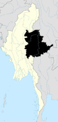
| State | Shan State |
| Self-Administered Division | Wa |
| Elevation[1] | 1,532 ft (467 m) |
| Time zone | MMT (UTC+6:30) |
Hopang Township (Burmese: ဟိုပန်မြို့နယ်) is a township of the Wa Self-Administered Division in the Shan State of Burma. The principal town is Hopang. It is one of the 6 townships of Wa Self-Administered Division.[2] It became part of Hopang District instead of Kunlong District in 2011.[3]
The 3 main routes which link Hopang and other parts are 804 mile long Hopang-Lashio-Mandalay-Taunggyi-Mongpyin-Matman Road, the 343 mile long Hopang-Lashio-Tangyan-Panghsan-Matman Road and the 257 mile long Hopang-Mongmao-Panghsan-Matman Road.[4]
Its total population before 1995 was 70,720 and Wa nationals were 24,024.[5]
There are 3,713 acres of rubber plantation in 2007.[6]
References
- ↑ GoogleEarth
- ↑ "Constitution of the Republic of the Union of Myanmar (2008)" Official English version
- ↑ http://www.mrtv3.net.mm/newpaper/69newsn.pdf Page 10 Column 3
- ↑ http://www.mrtv3.net.mm/newpaper/149newsn.pdf Page 10 Column 1
- ↑ http://www.ibiblio.org/obl/docs/BPS-NC-1994-09.htm "Self-administered areas and zones"
- ↑ MG page 8
Capital: Hopang | |
|

This article is issued from Wikipedia - version of the 11/29/2015. The text is available under the Creative Commons Attribution/Share Alike but additional terms may apply for the media files.