Outline of Oregon territorial evolution
Legend for maps
U.S. state
U.S. territory
Claimed by other countries
Disputed
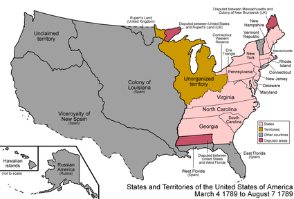
An enlargeable map of the United States after the Treaty of Paris in 1789
The following outline traces the territorial evolution of the U.S. state of Oregon.
Outline
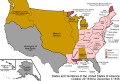
An enlargeable map of the United States after the Anglo-American Convention of 1818

An enlargeable map of the United States after the Adams-Onís Treaty took effect in 1821

An enlargeable map of the United States after the Oregon Treaty of 1846
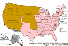
An enlargeable map of the United States after the Oregon Organic Act in 1848
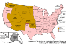
An enlargeable map of the United States after Oregon Statehood in 1859
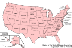
An enlargeable map of the United States as it has been since 1959
- Historical territorial claims of Spain in the present state of Oregon:
- Nueva California, 1768–1804
- Gran Cuenca, 1776–1821
- Alta California, 1804–1821
- Adams-Onis Treaty of 1819
- Historical international territory in the present state of Oregon:
- Oregon Country, 1818–1846
- Anglo-American Convention of 1818
- Provisional Government of Oregon (extralegal), 1843–1849
- Oregon Treaty of 1846
- Oregon Country, 1818–1846
- Historial political divisions of the United States in the present state of Oregon:
- Unorganized territory created by the Oregon Treaty, 1846–1848
- Territory of Oregon, 1848–1859
- Oregon Organic Act, August 14, 1848[1]
- Northern portion of Oregon Territory incorporated in new Washington Territory, March 2, 1853
- State of Deseret (extralegal), 1849–1850
- State of Oregon since 1859
- Oregon Statehood Act, February 14, 1859[2] (Eastern portion of territory transferred to Territory of Washington)
See also
 Territorial evolution of California
 Territorial evolution of Idaho
 Territorial evolution of Nevada
 Territorial evolution of Washington
References
- ↑ Thirtieth United States Congress (August 14, 1848). "An Act to establish the Territorial Government of Oregon" (cgi-bin). Retrieved June 5, 2009.
- ↑ Thirty-fifth United States Congress (February 14, 1859). "An Act for the Admission of Oregon into the Union" (cgi-bin). Retrieved June 5, 2009.
External links
This article is issued from Wikipedia - version of the 7/3/2012. The text is available under the Creative Commons Attribution/Share Alike but additional terms may apply for the media files.