Tuscola County, Michigan
| Tuscola County, Michigan | |
|---|---|
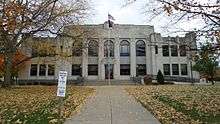 Tuscola County Courthouse in Caro | |
 Location in the U.S. state of Michigan | |
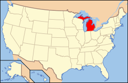 Michigan's location in the U.S. | |
| Founded |
April 1, 1840 organized March 2, 1850[1][2] |
| Seat | Caro |
| Largest city | Caro |
| Area | |
| • Total | 914 sq mi (2,367 km2) |
| • Land | 803 sq mi (2,080 km2) |
| • Water | 111 sq mi (287 km2), 12 |
| Population | |
| • (2010) | 55,729 |
| • Density | 69/sq mi (27/km²) |
| Congressional districts | 5th, 10th |
| Time zone | Eastern: UTC-5/-4 |
| Website |
www |
Coordinates: 43°28′N 83°27′W / 43.467°N 83.450°W
Tuscola County is a county located in the Thumb region of the U.S. state of Michigan. As of the 2010 census, the population was 55,729.[3] The county seat is Caro.[1][4] The county was created by Michigan Law on April 1, 1840, from land in Sanilac County and attached to Saginaw County for administrative purposes. The Michigan Legislature passed an act on March 2, 1850, that empowered the county residents to organize governmental functions.[1][2]
Tuscola County is one of five counties that are in the Thumb area. Like the rest of the thumb, Tuscola County enjoys seasonal tourism from larger cities like Flint, Detroit and Saginaw.
History
The name Tuscola was a Neologism created by Henry Schoolcraft. One scholar believes it to be a combination of "dusinagon" (level) and "cola" (lands).
The Chippewa/Ottawa word "dusinagon", or "tessi-nagan", actually, means flat dish or plate. The early Chippewa/Ottawa often used a shell or bark from a tree for a dish or plate. Shell in their language was "essi", which may be the root of Tuscola. The Thumb of Michigan, which includes Tuscola, Huron, and Sanilac Counties, was in the 17th century called Skenchioe, which may be related to the Onondaga word "uschwuntschios", which means plain or flat. It was said that Skenchioe, the early home of the Fox People, meant red fox. The French in the early 18th century called the Thumb of Michigan Le Pays Plat, which means The Flat Country. This name was continued by the English in the late 18th century in the name—Flat Country. The Chippewa/Ottawa word "tessi-" is used to make the words for shelf, platform, bench, and plate. The phrase "tessi-aki" may have been used by Algonquin speaking people to mean the entire Thumb of Michigan and meant level land. During the Saginaw Treaty of 1819, the Native chief of Tuscola was Chief Otusson. His name was said to mean "bench in the lodge or platform". The Thumb of Michigan forms a tableland with knolls or hillocks located in the interior part along the Cass River. The county seat of Tuscola is Caro, which is located along one of these large knolls. Caro was called by Native People High Bank. The land around Caro particularly to the north and east is cultivated and widely farmed. Caro is located in Indianfields Township, which was given its name for its plentiful Indian gardens.
Ottusson was also the name of the village of the Ojibwe near the start of the Cass River. It along with a large amount of surrounding land was reserved to the Ojibwe in the 1819 Treaty of Detroit but was sold off in the 1837 treaty.[5]
Geography
According to the U.S. Census Bureau, the county has a total area of 914 square miles (2,370 km2), of which 803 square miles (2,080 km2) is land and 111 square miles (290 km2) (12%) is water.[6]
Adjacent counties
- Huron County (north)
- Sanilac County (east)
- Saginaw County (west)
- Lapeer County (southeast)
- Genesee County (southwest)
- Bay County (west)
Major highways
 M-15, runs north and south
 M-24, runs north and south
 M-25, runs north and south
 M-46, runs east and west
 M-81, runs east and west
 M-138, runs east and west
Demographics
| Historical population | |||
|---|---|---|---|
| Census | Pop. | %± | |
| 1850 | 291 | — | |
| 1860 | 4,886 | 1,579.0% | |
| 1870 | 13,714 | 180.7% | |
| 1880 | 25,738 | 87.7% | |
| 1890 | 32,508 | 26.3% | |
| 1900 | 25,890 | −20.4% | |
| 1910 | 34,913 | 34.9% | |
| 1920 | 33,320 | −4.6% | |
| 1930 | 32,934 | −1.2% | |
| 1940 | 35,694 | 8.4% | |
| 1950 | 38,258 | 7.2% | |
| 1960 | 43,305 | 13.2% | |
| 1970 | 48,603 | 12.2% | |
| 1980 | 56,961 | 17.2% | |
| 1990 | 55,498 | −2.6% | |
| 2000 | 58,266 | 5.0% | |
| 2010 | 55,729 | −4.4% | |
| Est. 2015 | 53,777 | [7] | −3.5% |
| U.S. Decennial Census[8] 1790-1960[9] 1900-1990[10] 1990-2000[11] 2010-2013[3] | |||
The 2010 United States Census[12] indicates Tuscola County had a 2010 population of 55,729. This is a decrease of -2,537 people from the 2000 United States Census. Overall, the county had a -4.4% growth rate during this ten-year period. In 2010 there were 21,590 households and 15,423 families in the county. The population density was 69.4 per square mile (26.8 square kilometers). There were 24,451 housing units at an average density of 30.4 per square mile (11.7 square kilometers). 96.1% of the population were White, 1.1% Black or African American, 0.5% Native American, 0.3% Asian, 0.7% of some other race and 1.2% of two or more races. 2.8% were Hispanic or Latino (of any race). 32.3% were of German, 9.0% English, 8.4% Polish, 8.0% Irish, 7.8% American and 6.2% French, French Canadian or Cajun ancestry.[13]
There were 21,590 households out of which 30.9% had children under the age of 18 living with them, 56.5% were husband and wife families, 9.9% had a female householder with no husband present, 28.6% were non-families, and 24.0% were made up of individuals. The average household size was 2.52 and the average family size was 2.97.
In the county the population was spread out with 23.5% under age of 18, 7.9% from 18 to 24, 23.0% from 25 to 44, 29.8% from 45 to 64, and 15.8% who were 65 years of age or older. The median age was 42 years. For every 100 females there were 100.6 males. For every 100 females age 18 and over, there were 98.6 males.
The 2010 American Community Survey 3-year estimate[12] indicates the median income for a household in the county was $40,839 and the median income for a family was $49,274. Males had a median income of $28,288 versus $15,314 for females. The per capita income for the county was $19,470. About 1.7% of families and 17.2% of the population were below the poverty line, including 23.0% of those under the age 18 and 11.0% of those age 65 or over.
Religion
The Roman Catholic Diocese of Saginaw is the controlling regional body for the Catholic Church.[14]
Government
The county government operates the jail, maintains rural roads, operates the major local courts, keeps files of deeds and mortgages, maintains vital records, administers public health regulations, and participates with the state in the provision of welfare and other social services. The county board of commissioners controls the budget but has only limited authority to make laws or ordinances. In Michigan, most local government functions — police and fire, building and zoning, tax assessment, street maintenance, etc. — are the responsibility of individual cities and townships.
Elected officials
- Prosecuting Attorney: Mark E. Reene
- Sheriff: Lee Teschendorf
- County Clerk: Jodi Fetting
- County Treasurer: Patricia Donovan
- Register of Deeds: John Bishop
- Drain Commissioner: Robert Mantey
- Circuit Court Judge: Hon. Amy Gierhart
- Probate Court Judge: Hon. Nancy Thane
- District Court Judge: Hon. Kim David Glaspie
(information as of August 27, 2014)
Communities
Cities
Villages
Unincorporated communities
Charter township
General law townships
- Akron Township
- Arbela Township
- Columbia Township
- Dayton Township
- Denmark Township
- Elkland Township
- Ellington Township
- Elmwood Township
- Fairgrove Township
- Fremont Township
- Gilford Township
- Indianfields Township
- Juniata Township
- Kingston Township
- Koylton Township
- Millington Township
- Novesta Township
- Tuscola Township
- Vassar Township
- Watertown Township
- Wells Township
- Wisner Township
See also
- List of Michigan State Historic Sites in Tuscola County, Michigan
- National Register of Historic Places listings in Tuscola County, Michigan
References
- 1 2 3 "Bibliography on Tuscola County". Clarke Historical Library, Central Michigan University. Retrieved January 29, 2013.
- 1 2 Acts of Michigan Legislature
- 1 2 "State & County QuickFacts". United States Census Bureau. Retrieved August 29, 2013.
- ↑ "Find a County". National Association of Counties. Retrieved 2011-06-07.
- ↑ History of Sagimaw County, Michigan (Chicago: Chaples C. Chapman & Co, 1881) p. 155
- ↑ "2010 Census Gazetteer Files". United States Census Bureau. August 22, 2012. Retrieved September 28, 2014.
- ↑ "County Totals Dataset: Population, Population Change and Estimated Components of Population Change: April 1, 2010 to July 1, 2015". Retrieved July 2, 2016.
- ↑ "U.S. Decennial Census". United States Census Bureau. Retrieved September 28, 2014.
- ↑ "Historical Census Browser". University of Virginia Library. Retrieved September 28, 2014.
- ↑ "Population of Counties by Decennial Census: 1900 to 1990". United States Census Bureau. Retrieved September 28, 2014.
- ↑ "Census 2000 PHC-T-4. Ranking Tables for Counties: 1990 and 2000" (PDF). United States Census Bureau. Retrieved September 28, 2014.
- 1 2 "American Factfinder". United States Census Bureau. Retrieved March 11, 2012.
- ↑ "American FactFinder"
- ↑ Saginaw County Diocese home page,
Further reading
- Romig, Walter (1986) [1973]. Michigan Place Names: The History of the Founding and the Naming of More than Five Thousand Past and Present Michigan Communities. Great Lakes Books. Detroit: Wayne State University Press. ISBN 978-0814318386.
External links
- Tuscola County
- "Bibliography on Tuscola County". Clarke Historical Library, Central Michigan University. Retrieved January 29, 2013.
 |
Saginaw Bay | Huron County | | |
| Bay County and Saginaw County | |
Sanilac County | ||
| ||||
| | ||||
| Genesee County | Lapeer County |
Municipalities and communities of Tuscola County, Michigan, United States | ||
|---|---|---|
| Cities | | |
| Villages | ||
| Charter township | ||
| General law townships | ||
| CDP | ||
| Other unincorporated communities | ||
| Footnotes | ‡This populated place also has portions in an adjacent county or counties | |
Central/Mid-Michigan including the Tri-Cities and Thumb | |||||||||||
|---|---|---|---|---|---|---|---|---|---|---|---|
| Central cities | |||||||||||
| Counties |
| ||||||||||
| Geography | |||||||||||
| Transportation | |||||||||||
| Economy | |||||||||||