Wyoming, Michigan
| Wyoming, Michigan | ||
|---|---|---|
| City | ||
| City of Wyoming | ||
|
From top, left and right: Wyoming City Hall. Looking east down 28th Street, the city's main commercial route. Water tower near Gezon Park. | ||
| ||
| Motto: City of Vision and Progress | ||
 | ||
 Wyoming, Michigan Location in the United States | ||
| Coordinates: 42°54′49″N 85°42′20″W / 42.91361°N 85.70556°WCoordinates: 42°54′49″N 85°42′20″W / 42.91361°N 85.70556°W | ||
| Country |
| |
| State |
| |
| County |
| |
| Government | ||
| • Type | Council-Manager | |
| • Mayor | Jack Poll | |
| • City Manager | Curtis Holt | |
| Area[1] | ||
| • Total | 64.41 km2 (24.87 sq mi) | |
| • Land | 63.82 km2 (24.64 sq mi) | |
| • Water | 0.60 km2 (0.23 sq mi) | |
| Elevation | 196 m (643 ft) | |
| Population (2010)[2] | ||
| • Total | 72,125 | |
| • Estimate (2014[3]) | 74,826 | |
| • Density | 1,130.2/km2 (2,927.2/sq mi) | |
| Time zone | EST (UTC-5) | |
| • Summer (DST) | EDT (UTC-4) | |
| ZIP codes | 49509, 49519, 49418, 49503, 49508, 49548 | |
| Area code(s) | 616 | |
| FIPS code | 26-88940[4] | |
| GNIS feature ID | 1616863[5] | |
| Website | http://www.wyomingmi.gov | |


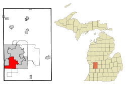
Wyoming is a city in Kent County, Michigan. As of the 2010 census, the city had a total population of 72,125. That makes it the 3rd largest community or city in West Michigan, the 14th largest city in the state of Michigan, and the 18th largest community in the state as well as being the largest suburb of Grand Rapids.
In 1832 the area was settled and organized under the Byron Township. In 1848 the township split the northern half being called Wyoming Township and then became a city in 1959 after a period of disputes surrounding annexation as well as water and sewer usage. The city has experienced population growth every census since the 1890 with some of the largest occurring after major wars.
History
Settlement
The area that is now the city of Wyoming was established first in 1832 and was one of the first populated areas in the county. Over the course of the next 16 years the area was incorporated as the Township of Byron. During this time the area that is now Grandville was populated at first by mills that used the Buck Creek to power its mills. In 1848 the township of Byron split with the name of Wyoming being used for the northern half. The name came from the Wyoming County, New York from which the majority of the residents came during the first 16 years. During this time the Township of Walker to the north took over a small portion of the new township as it was north of the Grand River and the ability to manage that land would be difficult.
Wyoming Township (1848–1959)
During the ensuing 50 years the township of Wyoming grew up slowly. The Grandville settlement in the northwest corner of the township grew the most and by 1884 had become the Village of Grandville and by 1893 had separated from the township. The City of Grandville was able to expand to its present size when it was able to grab land halfway between Byron Center and Ivanrest avenues a year before the township was incorporated as a city. Only the panhandle section from south of 50th Street was allowed to stay in the township and small effort was used to annex that section to Grandville that failed. In 1870 a settlement known as Fisher's Station developed around a station on the Grand Rapids and Indiana Railroad. It got a post office in 1871 and was platted in 1873.[6]
The next major area of development occurred in the northeast section of the township. The City of Grand Rapids started annexing portions of the township and by 1891 had annexed a square mile (2.6 km2) of the city from Division to Clyde Park and from Hall to Burton. A further section was annexed in 1916 that involved half-mile from Burton to Alger and from Clyde Park to Division. Further annexation attempts occurred during the ensuing 50 years and most failed. The population in the new northern areas of the city was populated mainly with workers for the furniture factories in Grand Rapids. That area was called the Urbandale neighborhood and ran along Chicago Drive from Burton northward. South of that was called the Galewood area and ran to roughly Cleveland Avenue. A final neighborhood grew up to the west of the Galewood and was called Burlingame and used Burlingame as its main street. That area was collectively called the Galewood-Urbandale-Burlingame or GUB. That section also provided the first school district for the township with the Godfrey-Lee. It had two major developments occur that caused some annexation attempts. The first was the Pere Marquette Rail yard and the second being the Kelvinator plant. The GUB area was proposed to become the city of Lee in 1939 but failed. Another attempt was made to consolidate with the City of Grand Rapids in 1949 and also failed. A last attempt at an annexation by the city of Grand Rapids in 1958 failed to secure the rail yard property with a strong push from the school districts of the then township.
Another major area of development occurred along the plank road Division in two separate areas. The northern area was the Godwin area and used the same name for the schools in that area. It happened to be split by both the townships of Wyoming and Paris. That area had faced numerous land grabs by the City of Grand Rapids mentioned above. The county in the 1950s had planned to move the county airport from its location in Paris Township to the present location. The school district and Wyoming Township had asked for it to handle the land development. The City of Grand Rapids also wanted the land and so a fight began. During this fight the township was able to become a new city in 1958 and seated in 1959. During the next few years a vote was taken to take three more sections of the city and the end result was only the airport was annexed by the City of Grand Rapids. The Godwin Heights Public Schools had previously voted to bring the rest of its Paris Township holdings into the city no more than a year after the previous section was added. Also during 1959, a vote was taken to bring all of the area into a single city but failed at the ballot box in all of the townships and cities outside of Grand Rapids. The end result of all of these ballot boxes was a July state supreme court ruling which brought the airport and surrounding holdings into Wyoming. A major reason the Godwin area was a prime candidate to be annexed was the GM Fisher Body Plant built in 1936.
The area to the south of Godwin was Fishers Station. It was developed with the rail road that ran in that general area from Grand Rapids to Kalamazoo. It then died off and was reformed with the name of Home Acres. In 1931 that area along with section of Godwin was proposed to become the village of Emerson but failed at the ballot box. A second attempt was made later with the name of South Grand Rapids but again failed traction. Since the threat of annexation of Grand Rapids was not there Kelloggsville became a school district split between the City of Wyoming and the Township of Paris, soon to be the City of Kentwood.
The vote to become a city was tried twice. The first time in 1956 and failed at the ballot box by a small margin. A 'scare' sheet was sent weeks before the vote about the water then being used by the township and how they should be annexing themselves with Grand Rapids instead. At the time the township had the most permits for housing and the need for water was on the minds of many home owners in the city. A second vote was launched in 1958 and passed by a margin of 1442 votes.
City of Wyoming (1959–present)
In the 1960s, the city was able to launch several projects. The first was a sewage plant to take care of issues from the state in regards to dumping it in the Buck Creek and Grand River. The next was the completion of the Water Plant in Holland with a pipeline to the city. A final project was the Complete Streets project. These projects made the city the way it was. New developments occurred over the years and the 28th Street projects allowed the creation of Rogers Plaza, one of the first indoor malls in the state let alone the country, and the neighboring Wyoming Village Mall in 1961. Flowerland Fruitbasket also opened in 1961 providing lawn care tools, flowers and outdoor furniture. Four years later in 1965, Studio 28 opened on the 28th Street corridor and expanded in size over decades into the world's first multiplex and the largest multiplex in the world in 1988.[7]
Following the 1999 opening of Rivertown Crossings Mall in Grandville near the southwest border of Wyoming, many commercial tenants left the 28th Street corridor to Grandville. More business was lost during the great recession, with the GM Fisher Body Plant closed due to budget cuts by General Motors. Much of the commercial atmosphere of 28th Street also dwindled down, with Studio 28 closing in 2008[8] and vacany rates up to nearly 40% in 2011.[9]
Later into 2010s, development has expanded in southern Wyoming. Gordon Foods has expanded its headquarters and Metro Hospital moved into the area attracting new businesses. Developments around Rivertown Crossings Mall on the southwest border with Grandville has pushed development in the panhandle region of the city as well.
Businesses
As of the 2000 census, there are presently 10 types of industries in the city. Manufacturing accounts for 30%, retail 16%, education, health, and social services 15%, with the next five industries accounting for 6%, and transportation, warehousing, utilities accounting for 3% of business in the city. The manufacturing segment is unique in that it is the largest in West Michigan. It currently produces auto parts, industrial machinery, commercial printing, plastics, food processing, electronics, tool and dies, concrete supplies, and fire engines.
After Grandville allowed development of a new 6-anchor shopping complex, Rivertown Crossings Mall, and the related development, many major retail businesses in Wyoming folded, including long-standing Roger's Department Store, its successor, and most tenants of Rogers Plaza. The city of Wyoming formed a Downtown Development Authority in an effort to help support the city in keeping businesses in the area in 1999.
In the 2000s, plans were being made to revitalize the 28th Street corridor.[10] In 2013, the City of Wyoming introduced the 28 West plan,[11] a plan to develop downtown Wyoming along 28th Street into a more pedestrian friendly environment that will provide food, retail and entertainement.[10] In June 2016, plans began moving forward on the 28 West plan with the demolishing of part of the Wyoming Village Mall and the creation of a new road through the surrounding parking lots to attract developers.[10]
Largest employers

According to the City's 2015 Comprehensive Annual Financial Report, the largest employers in the city are:[12]
| # | Employer | # of Employees | % of city employment |
|---|---|---|---|
| 1 | Metro Health Hospital | 2,454 | 4.71% |
| 2 | Gordon Food Service | 2,202 | 4.23% |
| 3 | Consumers Energy | 1,506 | 2.89% |
| 4 | UPS | 1,203 | 2.31% |
| 5 | Michigan Turkey Products | 640 | 1.23% |
| 6 | GM Components Holdings | 550 | 1.06% |
| 7 | Benteler | 486 | 0.93% |
| 8 | Wyoming Public Schools | 437 | 0.84% |
| 9 | Country Fresh | 402 | 0.77% |
| 10 | City of Wyoming | 333 | 0.64% |
Arts and culture
The city has 21 parks that cover about 665 acres (2.69 km2) which offer a multitude of activities.[13] The parks department has been active in the past decade in redeveloping the parks in the city. Many parks have been rebuilt which included adding new equipment, splash pads, and facilities. They have also added a few new facilities including a small skateboard park near one of the highest densities of the city. The city also offers a Senior Center that provides activities for the older citizens of the city and the region as a whole.[14] Along with the parks is the Kent Trails system that converted abandoned rail lines to bike paths. It is a collaborative effort between multiple local governments.[15] The most recent addition to the Wyoming Park System is the Dog Park located next to Marquette Park at the very northern edge of the city. It is a privately funded park with access controls to restrict usage to registered members.[16]
In 2002 the new Wyoming Public Library was built and is owned by the city but run by the Kent District Library System. It is a 48,950-square-foot (4,548 m2) facility with over 112,046 items. The library branch is also the highest attended in the Kent District system with 670,842 items checked out and 439,599 visits in 2009. The library currently has around 76% of the population holding a card to use the facility.[17] The building houses the Wyoming Historical Commission that provides history of the city.[18] Along with Historical Commission room, it houses the library for the blind and an art gallery.
Starting in 2005, the Wyoming-Kentwood Chamber of Commerce put together the 28th Street Metro Cruise. It currently spans 15 miles (24 km) from its start in Grandville at Wilson and 28th to its end in Cascade Township. The cruise runs on Friday and Saturday on the last weekend of August.[19]
Geography
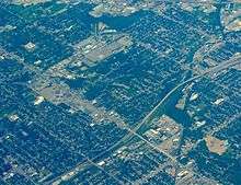
The city is situated southwest of Grand Rapids and south of the Grand River. Grandville and Georgetown Township in Ottawa County are to the west. Byron Township is to the south and the city of Kentwood to the east. U.S. Highway 131 (US 131) runs through the eastern side of the city and Interstate 196 (I-196) runs southwest–northeast along the Grand River. The newly completed M-6 (Paul B. Henry Freeway) runs along the south side of the city and connects I-196 with US 131 and I-96. M-11 runs east–west through the north of the city, also connecting with I-196, US 131, and I-96.
According to the United States Census Bureau, the city has a total area of 24.87 square miles (64.41 km2), of which, 24.64 square miles (63.82 km2) is land and 0.23 square miles (0.60 km2) is water.[1]
Weather
Wyoming is located just on the edge of the snow belt, where more snow tends to fall from lake effect snow coming off Lake Michigan. The lake also helps the area east of Wyoming in keeping warmer than usual. The record temperature in the area was 102 °F (39 °C) as its high in June and its low was set in January at −22 °F (−30 °C). Sunshine tends to be around 46% of the time with 43% of the year of temperatures reaching at least 65 °F (18 °C). Almost 40% the temperature dips below 32 °F (0 °C).
| Climate data for Wyoming, Michigan | |||||||||||||
|---|---|---|---|---|---|---|---|---|---|---|---|---|---|
| Month | Jan | Feb | Mar | Apr | May | Jun | Jul | Aug | Sep | Oct | Nov | Dec | Year |
| Average high °F | 30 | 32 | 42 | 57 | 69 | 79 | 83 | 81 | 73 | 61 | 46 | 34 | 57.3 |
| Average low °F | 16 | 17 | 25 | 36 | 46 | 56 | 60 | 59 | 51 | 41 | 31 | 21 | 38.3 |
| Average rainfall inches | 2.0 | 1.5 | 2.6 | 3.5 | 3.0 | 3.6 | 3.5 | 3.4 | 3.7 | 2.8 | 3.3 | 2.6 | 35.5 |
| Average snowfall inches | 20.2 | 11.9 | 10.0 | 3.0 | 0 | 0 | 0 | 0 | 0 | .7 | 7.7 | 18.1 | 71.6 |
| Average high °C | −1 | 0 | 6 | 14 | 21 | 26 | 28 | 27 | 23 | 16 | 8 | 1 | 14.1 |
| Average low °C | −9 | −8 | −4 | 2 | 8 | 13 | 16 | 15 | 11 | 5 | −1 | −6 | 3.5 |
| Average rainfall mm | 51 | 38 | 66 | 89 | 76 | 91 | 89 | 86 | 94 | 71 | 84 | 66 | 902 |
| Average snowfall cm | 51.3 | 30.2 | 25.4 | 7.6 | 0 | 0 | 0 | 0 | 0 | 1.8 | 19.6 | 46 | 181.9 |
| Source: Weatherbase[20] | |||||||||||||
Surrounding municipalities
 |
Walker | Grand Rapids | | |
| Grandville | |
Kentwood | ||
| ||||
| | ||||
| Hudsonville | Byron Township | Gaines Township |
Demographics
| Historical population | |||
|---|---|---|---|
| Census | Pop. | %± | |
| 1960 | 45,829 | — | |
| 1970 | 56,560 | 23.4% | |
| 1980 | 59,616 | 5.4% | |
| 1990 | 63,891 | 7.2% | |
| 2000 | 69,368 | 8.6% | |
| 2010 | 72,125 | 4.0% | |
| Est. 2015 | 75,275 | [21] | 4.4% |
| U.S. Decennial Census | |||
2010 census
As of the census[2] of 2010, there were 72,125 people, 26,970 households, and 18,128 families residing in the city. The population density was 2,927.2 inhabitants per square mile (1,130.2/km2). There were 28,983 housing units at an average density of 1,176.3 per square mile (454.2/km2). The racial makeup of the city was 75.8% White, 7.2% African American, 0.6% Native American, 2.8% Asian, 9.6% from other races, and 3.8% from two or more races. Hispanic or Latino of any race were 19.4% of the population.
There were 26,970 households of which 37.2% had children under the age of 18 living with them, 47.1% were married couples living together, 14.4% had a female householder with no husband present, 5.7% had a male householder with no wife present, and 32.8% were non-families. 25.6% of all households were made up of individuals and 7.3% had someone living alone who was 65 years of age or older. The average household size was 2.66 and the average family size was 3.22.
The median age in the city was 32.1 years. 27.1% of residents were under the age of 18; 10.5% were between the ages of 18 and 24; 29.9% were from 25 to 44; 23.5% were from 45 to 64; and 9% were 65 years of age or older. The gender makeup of the city was 49.3% male and 50.7% female.
2000 census
As of the census[4] of 2000, there were 69,368 people, 26,536 households, and 17,540 families residing in the city. The population density was 2,840.1 per square mile (1,096.8/km²). There were 27,506 housing units at an average density of 1,126.2 per square mile (434.9/km²). The racial makeup of the city was 84.32% White, 4.85% African American, 0.59% Native American, 2.92% Asian, 0.04% Pacific Islander, 4.70% from other races, and 2.59% from two or more races. Hispanic or Latino of any race were 9.66% of the population.
There were 26,536 households out of which 35.7% had children under the age of 18 living with them, 49.6% were married couples living together, 12.0% had a female householder with no husband present, and 33.9% were non-families. 26.6% of all households were made up of individuals and 7.4% had someone living alone who was 65 years of age or older. The average household size was 2.60 and the average family size was 3.19.
In the city the population was spread out with 28.0% under the age of 18, 10.9% from 18 to 24, 33.7% from 25 to 44, 18.0% from 45 to 64, and 9.4% who were 65 years of age or older. The median age was 31 years. For every 100 females there were 97.5 males. For every 100 females age 18 and over, there were 95.0 males.
The median income for a household in the city was $43,164, and the median income for a family was $50,002. Males had a median income of $35,772 versus $25,482 for females. The per capita income for the city was $19,287. About 5.1% of families and 7.3% of the population were below the poverty line, including 8.8% of those under age 18 and 6.9% of those age 65 or over.
Government
The city has a council-manager government with both an elected mayor and an appointed city manager. Currently, Jack Poll serves as Wyoming's mayor after defeating former council member Roger Haynes in 2009. The city council is composed of six members: three at-large and a representative from each of the three wards. The current council members are: Kent Vanderwood, Dan Burrill, Sam Bolt (mayor pro-tem), William Ver-Hulst (1st Ward), Richard Pastoor (2nd Ward), and Joanne Voorhees (3rd Ward). Meetings are held at the City Hall on the first and third Mondays of every month. Work sessions are held the second Monday of each month.
Public safety
Health care
On September 30, 2007 Metro Health Hospital moved from southeast Grand Rapids to its current location on the south central section of Wyoming.[22] They along with Spectrum Health and St Mary's have small centers for urgent care with their hospitals located in downtown Grand Rapids.
Police Department
Established in 1848, a four-man constabulary, elected each April, maintained law and order in Wyoming Township until December 12, 1941.
The Wyoming Township Police Department was founded on December 12, 1941. The Department was staffed with three full-time police officers. The three officers were constables at the time of the organization of the Police Department, and were affectionately known as the "Wyoming Cowboys". The 15’ x 15’ Police Department was stationed within the Township Hall that was located at Burton and Godfrey. During that year, the constables protected 25,000 residents, and responded to 603 calls for service.
During the mid-1940s the Police Department then moved into office space at 1263 Burton, the current location of the Koeze Retail Store. In November 1948, the Township Offices were moved from Burton Street to the Beltline (the present location of City Hall). The Police Department occupied an office within the Township Hall.
On January 1, 1959, Wyoming Township became a city. Consequently, the Wyoming Township Police Department of seventeen sworn officers became the City of Wyoming Police Department.[23]
In 2013, Wyoming Police Department and Wyoming Fire Department amalgamated their administrative offices into the (former) Police Headquarters building, creating the new entity of Wyoming Department of Public Safety.[24]
Education

Currently the city is served by 5 school districts. In the southwest panhandle is served by Grandville Public Schools, the central part is served by Wyoming Public Schools, the southeast is served by Kelloggsville Public Schools, the northeast is served by Godwin Heights Public Schools, and finally the northern section of the city is served by Godfrey-Lee Public Schools.
Of the five districts only 1—Grandville Public Schools—does not have the majority of the buildings in the city. The remaining have 13 elementary schools out of 15, 3 out of 4 middle schools, all four high schools, with Godfrey-Lee providing a combination middle high school in the city.
The city is also served for college by Grand Rapids Community College in downtown Grand Rapids. In Allendale, northwest of the city, is Grand Valley State University. Further universities can be found in Lansing, Big Rapids, and Kalamazoo. Also located in the immediate area is Hope College in Holland, Davenport University in Caledonia Township, Calvin College on the east side of Grand Rapids, Aquinas College also on the east side of Grand Rapids, Cornerstone University on the northeast side of Grand Rapids, along with Grace Bible College in the city as well. The Protestant Reformed Theological Seminary located in 4949 West Ivanrest Ave Wyoming, Michigan.[25]
Infrastructure

Transportation
Public Transit
The city is part of the Grand Rapids-based Interurban Transit Partnership, called the Rapid. It currently runs Routes 1, 3, 8, 10, 16, 24, 28, and 44 in the city; that is 8 out of the 26 routes. Currently the U.S. Department of Transportation is funding a good portion of a new transit system for the area. It will run along Division Avenue on the east side of the city from its southernmost point to the downtown. It is a bus rapid transit system with only 5 projected stations on the route inside of the city. The new line will be run by the Rapid.
Major highways
-
 M-6 runs east to west on the southern edge of the city, although only a small section of the city sits on the highway.
 -
 M-11 runs east to west in the middle section of the city.
 -
 US 131 runs south to north through the city.
 -
 I-196 along the west and north side of the city.
 -
 BS I-196 runs on the local street called Chicago Drive from center west to the north east.
Utilities
Currently the city provides water and sewer to the majority of the citizens. Electricity is supplied by Consumers Energy with natural gas nominally supplied by DTE Energy. Garbage service is supplied by individual contractors to home owners and by law they are required to use the county incinerator although the city does provide a yard waste drop off center. For both phone and cable service is supported by both AT&T and Comcast. Cell phones carriers are on the whole fully supported with a number of towers.
Notable people
- Buster Mathis – professional boxer
- Buster Mathis, Jr. – heavyweight champion professional boxer
- Chris Kaman – NBA center – New Orleans Hornets
- Drew Neitzel – Michigan State University basketball guard
References
- 1 2 "US Gazetteer files 2010". United States Census Bureau. Archived from the original on January 24, 2012. Retrieved 2012-11-25.
- 1 2 "American FactFinder". United States Census Bureau. Retrieved 2012-11-25.
- ↑ "Population Estimates http://quickfacts.census.gov/qfd/states/26/2688940.html]". External link in
|title=(help); - 1 2 "American FactFinder". United States Census Bureau. Archived from the original on September 11, 2013. Retrieved 2008-01-31.
- ↑ "US Board on Geographic Names". United States Geological Survey. 2007-10-25. Retrieved 2008-01-31.
- ↑ Walter Romig, Michigan Place Names, p. 198
- ↑ "Studio 28 History Timeline". Celebrationcinema.com. Retrieved 2014-06-10.
- ↑ "Cinemas Around the World - Studio 28 Theatre, Wyoming MI". CinemaTour. Retrieved 2014-06-10.
- ↑ "TURN ON 28TH STREET" (PDF). City of Wyoming. Retrieved 18 August 2016.
- 1 2 3 McAboy, Koco (24 June 2016). "28 West project in Wyoming moving forward". WOOD-TV. Retrieved 18 August 2016.
- ↑ ""28 West": City Of Wyoming Looking To Transform 28th Street". FOX17. 28 August 2013. Retrieved 18 August 2016.
- ↑ "Comprehensive Annual Financial Report For Fiscal Year Ended June 30, 2015" (PDF). City of Wyoming. Retrieved 15 August 2016.
- ↑ "Parks". Parks & Recreation Department, City of Wyoming. Retrieved November 2, 2010.
- ↑ "Wyoming Senior Center". Parks & Recreation Department, City of Wyoming. Retrieved November 2, 2010.
- ↑ "Kent Trails". Kent County Parks Department. Retrieved November 2, 2010.
- ↑ "Wyoming Dog Park". Parks & Recreation Department, City of Wyoming. Retrieved November 2, 2010.
- ↑ "Wyoming Branch" (PDF). Kent District Library. Retrieved November 2, 2010.
- ↑ "Wyoming Historical Commission". Wyoming Historical Commission, City of Wyoming. Retrieved November 2, 2010.
- ↑ "History". 28th Street Metro Cruise. Retrieved November 2, 2010.
- ↑ "Historical Weather for Grand Rapids, Michigan". Weatherbase. Retrieved November 12, 2008.
- ↑ "Annual Estimates of the Resident Population for Incorporated Places: April 1, 2010 to July 1, 2015". Retrieved July 2, 2016.
- ↑ "History". Metro Health. Retrieved November 13, 2010.
- ↑ "History". Retrieved August 10, 2011.
- ↑ City of Wyoming Community Profile" prepared by the Wyoming Planning and Development Department, Summer 2007.
- ↑ Protestant Reformed Theological Seminary website, prca.org; accessed December 23, 2014.
External links
Municipalities and communities of Kent County, Michigan, United States | ||
|---|---|---|
| Cities | 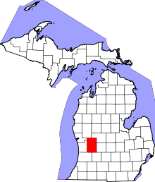 | |
| Villages | ||
| Charter townships | ||
| General law townships | ||
| CDPs | ||
| Other unincorporated communities | ||
| Footnotes | ‡This populated place also has portions in an adjacent county or counties | |