Changwon
| Changwon 창원시 | |
|---|---|
| Specific city | |
| Korean transcription(s) | |
| • Hangul | 창원시 |
| • Hanja | 昌原市 |
| • Revised Romanization | Changwon-si |
| • McCune-Reischauer | Ch'angwŏn-si |
|
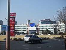
Downtown | |
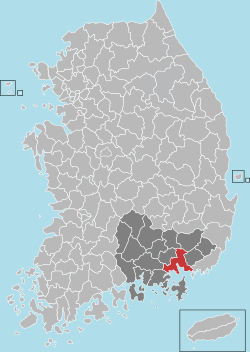 Location in South Korea | |
| Coordinates: 35°16′15″N 128°39′47″E / 35.27083°N 128.66306°ECoordinates: 35°16′15″N 128°39′47″E / 35.27083°N 128.66306°E | |
| Country |
|
| Region | Yeongnam |
| Established | 1408 |
| Administrative divisions | 5 Gu, 2 eup, 6 myeon |
| Government | |
| • Mayor | Ahn Sang-soo |
| • Council Chairman | Isu-Kim |
| Area | |
| • Total | 747.12 km2 (288.46 sq mi) |
| Elevation | 2 m (7 ft) |
| Population (August 2015[1]) | |
| • Total | 1,070,199 |
| • Density | 1,432/km2 (3,710/sq mi) |
| • Dialect | Gyeongsang |
| Time zone | UTC+09:00 |
| Website | Changwon Office |
Changwon is the capital city of Gyeongsangnam-do, South Korea. Changwon is the 8th most populated city in South Korea, with an established population of 1,089,039 people in 2010.[2] It encompasses a land area of 747.12 square kilometres (288.46 sq mi)[3] on the southeastern coast of South Korea. The population of southeastern Korea, including the city of Busan, is more than 6,478,000. Changwon is known as a heavy industrial city.[4] The city only covers 7% of Gyeongsangnam-do province, also known as Gyeongnam, but holds 33.6% of its population; it also accounted for 38.5% of the total 2.1821 trillion won budget of the Gyeongnam province.[5]
In 209 AD (Naehae 14), during the Three Kingdoms period, Changwon was named Gulja-gun, a province of the Silla kingdom. In 757 (Gyeongduk 16) Changwon was renamed Uian-gun during the reorganization of all Silla provinces.
In 1408 (Taejong 8) during the Joseon period, King Taejong established Changwon-bu. In 1415 (Taejong 15), King Taejong renamed Changwon-bu to Changwon-dohobu and it became the capital of the Gyeongnam province.
On April 1, 1974 Changwon was designated 'Industrial Base Development Area No. 92.' As a result, the city was developed and significantly expanded.
On July 1, 2010, the neighboring cities of Masan and Jinhae merged with the city to form a single larger urban area that makes up the current city of Changwon. These three constituent cities are located in the Masan Bay Area.
History
Prehistory and early history
Masan Bay was wide open toward the hilly lands of the coastal plain in the Bronze Age, and there are many ruins dating from the Iron Age in the area. Typical Iron Age landmarks include Bangyedong monuments, dolmens, holy mounds, lower molar sites, and dolmens from Bronze Age settlements. it also known as a heavy industrial area of Korea.
Three Kingdoms and Dynastic Period

During the Three Kingdoms Period, the area that now forms Changwon was part of the territory of Byunhan. During the Unified Silla Period, this region was renamed to Uian-gun, then in the Goryeo Period, to Uichang-hyeon.

During the Jeolla dynasty period, Changwon-bu Administrative District, so named in 1408 (Taejong 8), was renamed to Changwondohobu Administrative District in 1415 (Taejong 15). Suffered after the 1601 (Sunjo 34) invasion in the Changwon-daedohobu (Gyeongnam Capital of Joseon Period) was promoted to. Late in the administrative and military center in Changwon, South Gyeongsang Province and represents a capital. Confucian's defeated (殿牌) is lost in the wake of the case nine years been derided as little more than present in Changwon, but again, Changwon-daedohobu been promoted to persist until the end of the Joseon was. Today, Changwon, South Gyeongsang Province to the current namdocheong This material has a capital role.
After Korean War
1960s
On 15 March 1960, a movement arose against the election of the totalitarian Syngman Lee government in Changwon (before Masan). This is decisive opportunity to spark a revolution 4.19
1970s
Changwon was selected in 1974 to be an industrial and residential centre, as well as the provincial capital. Changwon city planning district announced on 1 April 1974 that Changwon was designated 'Industrial Base Development Area No. 92', and industrial development in Changwon was to proceed as part of the development plan. The Changwon Industrial Complex was built to the south of the city. Changwon is a planned city, taking Canberra, Australia as a model. After Canberra, Brasília in Brazil, and New Delhi in India, it was the fourth planned city in the world, and is Korea's first planned city.[6]
The country's longest straight road was constructed in Changwon, with a length of 15.27 kilometres (9.49 mi),[7] with the industrial park to the south and residential complexes constructed to the north. The current plan is an independent foundation in Changwon city, the urban master plan is September 1, 1976 Industrial and promoting the development and efficient management of the city behind for the administrative district of Masan, Changwon, remove it from the earth as the 1977-1986 Area Plan 171.560㎢(42,393ac), was established based on population 300,000.
Transit time is scrupulous and a 50 metres (160 ft) wide park was created from east to west through the central region of Changwon, South central area of the Main Street running through the width is 25 m (82 ft).
In the 1970s, The 3rd Economic Development five years (1972–1976) according to the plans of the heavy and chemical industries' machinery industry 100 billion export target, the ranks of industrialised nations settled in the 1980s', depending on the goal, 19 September 1973 President Park Chung Hee 'instructions on the construction of Changwon Machinery Industrial Base' is a top-down April 1, 1974 Changwon industrial base for the development of industrial base development is determined by promoting regional development has begun.
Companies in the Benefits Agency, including the selection and move into action to attract companies produce 1.5 billion won in 1975, exports from $600,000 in 1979, producing 450.6 billion won, raise export earnings $1,650,000.
1980s
South Gyeongsang Province in June 1982 was the previous Government. Government prior to the industrial park behind the city administration, social, cultural and economic changes such as the center of all the fields.
Redefining the basic structure was the city in 1983. This is the point of Changwon and tapped the centre axis between the central commercial areas, transport, administrative districts, cultural, educational and contentment is to have the system up into sections.
In particular, the 1984 Korea's best city for the construction of the power of 'the city plans to make park five years' developed. Until 1988 the park was developed 11. This is the OECD, Changwon City (average 19.80㎡) was higher than that, one of the nation's top per capita green space area (32.3 square metres (348 sq ft)) with the foundation said. Both apartments and housing development has begun.
2nd oil crisis in 1979 the economy was not good, VTR, due to increased overseas demand, such as semiconductor automation equipment, machinery, high-tech product development, production, etc. 5,023.7 billion Won, exports 1.428 billion U.S. dollars compared with 70 in 1,000 percent and has grown 765 percent.
1990s
2000s
2008 in Changwon, South Gyeongsang 10th Conference of the Ramsar Convention was held.[8]
October 22, 2008 Public bike 'Nubija' was introduced. 3 May 2009 President Lee Myung-bak took part in the bikes festival held in Changwon with Changwon citizens.[9]
June 2, 2010 nationwide local elections, Wansu-Park was elected mayor of Changwon city.[10]
On July 1, 2010, the three neighboring cities, Masan, Changwon and Jinhae unified to create Unified Changwon City, with population of 1.08 million.[11]
Changwon Industrial Complex in September 2010 was over 2,000 tenant companies. Companies is 97.8 percent(1,957) small and medium businesses, large corporations and 2.2 percent in all 44 companies.[12]
Geography

Changwon is located on the southern coast of Korea and has Masan Bay and Jinhae within its boundaries. The city is surrounded by a series of ridges, with Mt. Bulmo (802 metres (2,631 ft)), Mt. Jeongbyeong (567 metres (1,860 ft)), and Mt. Jangbok (582 metres (1,909 ft)) as the highest peaks. The wide alluvial plain of the northeastern coast of the Nakdong River is considered the breadbasket of South Gyeongsang Province.
Dot island, Sokuri island, and several uninhabited islands are part of the city.
Climate

The city has four distinctive seasons. The average temperature is 12.9 °C (55.2 °F) and the average annual precipitation is 1,527 millimetres (60.1 in). From 1992−2001 the average annual temperature was 15 °C (59 °F) and the average annual rainfall was 1,395 millimetres (54.9 in).
Between 1980 and 1990 there was an annual average of around 116 sunny days a year (32 percent of the possible total), and between 1990 and 2000 an average of 135 (37 percent).
The driest year on record was 1994, with a total of 718 millimetres (28.3 in) of precipitation; the wettest year was 1991 with 2,046 millimetres (80.6 in).
| Climate data for Changwon (1981–2010) | |||||||||||||
|---|---|---|---|---|---|---|---|---|---|---|---|---|---|
| Month | Jan | Feb | Mar | Apr | May | Jun | Jul | Aug | Sep | Oct | Nov | Dec | Year |
| Average high °C (°F) | 7.3 (45.1) |
9.6 (49.3) |
13.6 (56.5) |
19.3 (66.7) |
23.2 (73.8) |
25.9 (78.6) |
28.8 (83.8) |
30.2 (86.4) |
27.0 (80.6) |
22.3 (72.1) |
15.9 (60.6) |
10.3 (50.5) |
19.4 (66.9) |
| Daily mean °C (°F) | 2.8 (37) |
4.7 (40.5) |
8.7 (47.7) |
14.1 (57.4) |
18.4 (65.1) |
21.7 (71.1) |
25.2 (77.4) |
26.5 (79.7) |
22.8 (73) |
17.4 (63.3) |
11.0 (51.8) |
5.4 (41.7) |
14.9 (58.8) |
| Average low °C (°F) | −1.0 (30.2) |
0.5 (32.9) |
4.5 (40.1) |
9.7 (49.5) |
14.3 (57.7) |
18.5 (65.3) |
22.7 (72.9) |
23.6 (74.5) |
19.4 (66.9) |
13.2 (55.8) |
6.8 (44.2) |
1.3 (34.3) |
11.1 (52) |
| Average precipitation mm (inches) | 36.9 (1.453) |
45.3 (1.783) |
74.3 (2.925) |
129.9 (5.114) |
142.2 (5.598) |
232.3 (9.146) |
293.8 (11.567) |
299.0 (11.772) |
167.3 (6.587) |
50.2 (1.976) |
52.2 (2.055) |
22.0 (0.866) |
1,545.4 (60.843) |
| Average precipitation days (≥ 0.1 mm) | 5.1 | 4.6 | 7.4 | 8.0 | 9.3 | 10.4 | 13.9 | 12.2 | 8.5 | 4.2 | 5.1 | 3.5 | 92.2 |
| Average relative humidity (%) | 50.8 | 51.8 | 56.8 | 60.9 | 67.7 | 75.5 | 80.2 | 76.5 | 70.7 | 62.3 | 58.3 | 53.4 | 63.8 |
| Mean monthly sunshine hours | 179.7 | 183.6 | 190.5 | 209.2 | 205.5 | 160.4 | 136.9 | 159.4 | 158.0 | 205.5 | 179.6 | 176.7 | 2,145 |
| Source: Korea Meteorological Administration[13] | |||||||||||||
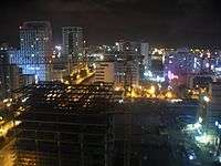
Cityscape

Administrative divisions
It has 5 districts (Gu).[14]
| Map | |||
|---|---|---|---|
| District | Hangul | Hanja | Area (km²)[3] |
| Uichang-gu | 의창구 | 義昌區 | 211.17 |
| Seongsan-gu | 성산구 | 城山區 | 82.20 |
| Masanhappo-gu | 마산합포구 | 馬山合浦區 | 240.65 |
| Masanhoewon-gu | 마산회원구 | 馬山會原區 | 90.58 |
| Jinhae-gu | 진해구 | 鎭海區 | 122.52 |
- Uichang is the old name of Changwon. When the king of Silla gyeongdeok, Guljagun is Uian-gun.
- Consider the times in 1282 (King of chungryeol 8), Guljagun changed name Uichanggun.
- Chosun era, 1408 (king of Taijong 8) Uichang Prefecture and Hoewonhyeon (Masan's old name) was incorporated as part Changwon.
- Jinhae (formerly known as Chinhae) is a district in Changwon City, South Korea. This region is served by the Korean National Railroad, and is famous for its annual cherry blossom festival every spring.
Neighborhoods
Changwon National Industrial Complex
• Area: 25,302 km2
• Number of Employees: 82,000
• Volume of Manufacture: 40.1447 trillion KRW
• Exports: 15.217 billion USD
• Production Rate by Industry: Machinery 64%, Transportation Equipment 16%, Steel 10%, Electronics 8%, Others 2%
Changwon National Industrial Complex was created by the heavy chemical industry development policy of the Korean government in 1974. Changwon National Industrial Complex lead the chemical industrial and heavy machinery sectors of the Korean economy and is now a very important heavy industries center in the country.
The development of Changwon into an industrial city during the 1960s and 70s has led to a city structure that is strictly bifurcated by one main avenue called "Changwon Daero"(Changwon big road); to the south are the factories, to the north are Sangnam-dong and all of the residential areas. Changwon Daero also serves as emergency runway for military purposes.
Financial district and Government district
Financial district located southern part of Jungang-dong and Sangnam-dong. (upper side of City hall)
Government district located northern part of Youngho-dong and Shinwol-dong. (lower side of City hall)
Sangnam-dong
The Sangnam neighborhood is the central part of greater Changwon. The main part of this neighborhood, Sangnam Commercial District(상남상업지구), is the main nightlife area, with many bars, hotels, business bars, norae-bangs (singing or karaoke rooms) and restaurants. On every day of the month with a date that ends in 4 or 9 the market "Sangnam-sijang" is open and bustling for business. This is the largest farmer's market within the city, with vendors selling fresh seafood, vegetables, and other groceries as well as nonperishables such as clothing and pottery. There is also a large-scale residential complex of high-rise apartments.
Jungang-dong
Jungan-dong, located just west of Sangnam, is the "old town" and extended central area of the city. There is more nightlife here than restaurants, and local English speaking expats often frequent the area for drinks and laughs, often living very nearby. This is the most likely place to meet one of the foreign English teachers, engineers and armed services residence of the area.
Hapsung-dong
Hapsung-dong is the central district of the old city of Masan, now located within the city of Changwon and near the Masan harbor. Hapsung's streets are much narrower than most of the rest of Changwon, because of the planned aspects of old Changwon sector, and traditional aspects of old Masan sector.
Daebang-dong
Daebang-dong is known as the 'inner city' section of Changwon. Residential and commercial districts are present in the area.
Yongho-dong
Yongho-dong is the counter-culture area of Changwon.
Changdong-art village
This district has many murals and artworks through streets. This district was old town. City government and citizen make this district for artist. City government support artist to do there masterpiece.
Also there are many small galleries.
Beaches and Parks
Several of Changwon's parks and nearly all of its beaches form all of urban area. Changwon has Beaches before city became urbanization and industrialization. Changwon have plan making and recovering beaches, which has been used for beaches and waterfront. The recovering plan is at Woo-do(Woo island) that length of 300m, a width of 20 ~ 30m beaches. and further plan is located Sokuri island and Gwangam Beaches.
List of Parks in Changwon.
Olympic Park
Yongji Park
Chrysanthemum Park
Namsan Park
Pyeongsan Park
Sangnam Park
Bansong Park
Gaumjung Park
Daewon Park
Samdon Park
Naedong Park
Jungang Park
Gaumjung Sports Park
Rose Park
Youth Park
Daebang Green Park
Sangnam square
Samjungja Park
Jindong Park
Manal Park
Sehang Park
Guhang Park
Sanho Park
Jasan Park
Yangduk Park
Paryeong Park
Jehang Mt Park
Pungho Park
Jangbok Mt Park
hindolmae Park
Jinhae Seashore Park
Economy
Changwon city is a hub of factories that heavy industry for many major companies, including Samsung Techwin, GM Korea, LG Electronics, Hyundai Rotem, Doosan Heavy Industries & Construction, Doosan Infracore, Doosan Engine, Hyosung, Hyundai Wia and STX Corporation. And also Jinhae-gu there is Korea Naval Base (Republic of Korea Navy) that is main economy. Masan has Export processing zones,it is like a free port zone. Changwon city is the capital of Gyeongnam-do(state). So Changwon has many government agencies.
Gross Regional Domestic Product of Changwon city is 21.7 trillion won which is higher than that of Gwangju and Daejeon.[15] It earned 29 billion dollars through exports in 2008, higher than that of Busan, Gwangju, Daejeon and Daegu.
Education and health
Education
Changwon city has seven universities and colleges: Changwon National University, Kyungnam University, KNA(Korea Naval Academy), Changwon College, Masan college, Chang Shin College and Korea Politechnic 7 College (Changwon Polytechnic College).
Changwon has 46 high schools, 63 middle schools, 105 elementary schools and 193 kindergartens, including two special-purpose high schools: Changwon Science High School and Changwon Mechanical Technical High School.[16]
Changwon National University was established in 1969 and was re-established in 1985. It has approximately 15,000 graduate and undergraduate students.[17]
Kyungnam University was founded in 1946 as Kookmin College in Seoul. The tumultuous Korean War years created a situation in which it was more advantageous to move south than to stay in the Seoul area. In 1961, the institution was renamed yet again with the new geo-specific moniker of Masan College. In 1970, the Hanma foundation took over the college and in 1971 the foundation decided to rename the college yet again, so the signs were changed to read "Kyungnam College." In 1982, the institution attained university status and the name was officially altered one more time. Since 1982, there has been no revision to the name and it has remained "Kyungnam University."[18] it has approximately 18,000 graduate(2,000) and undergraduate students(16,000).[19]
KNA(Korea Naval Academy) was established in 1946.[20]
Health care
Korea Accident Medical Center in Changwon, National Masan T. B. Hospital, Hanmaum Hospital, Changwon Fatima Hospital, Jinhae Naval Hospital and Changwon Samsung Hospital-Sungkyunkwan University.
Changwon Department of Public Health is health institutions in Changwon city to improve disease prevention, care and public health.
-Changwon Health Center, Changwon Health Promotion Center, Masan Health Center, Jinhae Health Center.[21]
Culture and contemporary life
Changwon has many parks and gardens throughout the city which give it a different feel from places such as Busan. For example, Yongji Park contains a small lake with a jet-fountain and hosts laser light shows at night.
The Junam Reservoir is an important bird migration site and the largest in Korea. During the peak winter season, an average of 30,000 to 40,000 birds a day can be seen there. There is a birdwatching festival there each year.
Azaleas bloom on the hillsides around Changwon for a short time in the spring and the city hosts two one-day festivals to commemorate the phenomena. The city is close to the seaside city of Jinhae. Each spring Jinhae has a tree blossom festival that attracts many Changwonians.
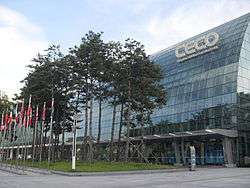
Changwon is also home to the Changwon Exhibition Convention Center (CECO), located adjacent to the City 7 lodging and shopping complex. CECO hosted the 2008 conference of parties to the Ramsar Convention.
Changwon Stadium, Changwon Indoor Swimming Pool, Changwon Football Center, Masan Stadium, Masan Baseball Stadium, Jinhae Public Stadium, Changwon West Sports Centre, Gym civic life center, Evergreen Hall.
Sports
Changwon hosts four professional sports teams: a basketball team - the Changwon LG Sakers - that plays in the KBL, two association football clubs - Gyeongnam FC and Changwon City FC - that play in the K League Challenge (the second tier of Korean football) and the National League (the third tier of Korean football), respectively, and a baseball team - the NC Dinos - that plays in the KBO League. Prior to the league awarding the Dinos to Changwon as an expansion team in 2011, the Lotte Giants would play a few series per season at Masan Baseball Stadium in what was then the city of Masan. Changwon absorbed Masan in 2010, and Masan Stadium, located in what is now Changwon's Masanhoewon-gu, serves as the home stadium for the Dinos while the city builds a new stadium next to the current stadium, tentatively set to open in 2016.[22]
| Club | Sport | League | Venue | Established |
|---|---|---|---|---|
| Changwon LG Sakers | Basketball | KBL | Changwon Gymnasium | 1997 |
| Changwon City FC | Association football | National League | Changwon Football Center | 2005 |
| Gyeongnam FC | Association football | K League Challenge | Changwon Football Center | 2006 |
| NC Dinos | Baseball | KBO League | Masan Baseball Stadium | 2011[23] |
There is also a Formula 3 race, the Korea Super Prix.
Festivals
- Changwon festival(In October)
- Gagopa flower festival (In October)
- Jinhae gunhang festival (In April)
See Wikipedia Jinhae page: Cherry Blossom Festival
Festival Website : http://english.visitkorea.or.kr/enu/SI/SI_EN_3_2_1.jsp?cid=700520
- Masan Seafood Market Festival (In Fall)
- Masan International Theater Festival (on May)
- Jindong seafood festival (In April)
Museums
- KNA Museums (Korea Naval Academy Museum)
- Masan Museum
- Kyungnam University Museum
- Changwon National University Museum
- Energy Science and Environment Park
- Jinhae Museum
- Folk Art Village & Historical Jinhae Museum
- Changwon Science Center
- 3•15 Art Museum
- Munsin Museum
- Gyeongnam Provincial Museum
- Daesan Museum
Media
Changwon is a provincial center for the television, newspaper and publishing industries, which are Changwon KBS, Changwon MBC, Gyeongnam News and The Kyongnamdomin Ilbo.
Transportation
Public transport
Bike sharing
Changwon is served by the Nubija bike sharing system [24] which stands at around 5,000.
Roads and highways
Namhae highway 10, Guma highway 102, Changwon boulevard, woni boulevard, gongdan boulevard, Road 5, Road 25, Road 2. Changwon Cross-Country Bus Terminal Station, Masan Cross-Country Bus Terminal Station and Jinhae Cross-Country Bus Terminal Station.
Rail
The city is on the Gyeongjeon Line (Gwangju-Samnangjin). This line stretches along the southern coast and links Jeolla and Gyeongsang regions. Usually, this line is regarded as a set of branch lines, which feed local traffic into adjacent major lines. Some KTX trains detour to Changwon.
Changwon city has 9 train stations: Changwon central station (Changwon JungAng), Changwon Station, Masan Station, Sin Changwon Station, Changwon south(closed), Sungju temple station (closed), Ducksan Station, Jungri station.
Changwon is also served by the Jinhae Line.
Seaports
Masan port is main port in changwon city.
Changwon port is sub port of Masan port.
Jinhae port is a port of Korea Navy.
Pusan New Port is new port in Korea. It is located between Busan and Jinhae.
Airport
Gimhae International Airport (PUS) is 35 km away from the city center. In 2010, the airport was the 3rd busiest in South Korea, handling over 8.2 million passengers.
Metro
Changwon city government plan to build a metro system in 2021. It is planned to be 33.9 km (21.1 mi) through the city.
City symbol, mascots, and slogan
The symbol of Changwon is a blue square with each line being extended slightly in one direction. Four small squares appear outside the square on the non-extended side of each line. They are colored red, green, yellow and blue following clock-wise starting from the top. The extended square represents the planned road network system of Changwon, and the city advancing in all directions. The small blue square represents the state-of-the-art industrial base, the small green square represents the environment friendly city, the small yellow square represents the citizens, and the small red square represents the energy that sustains the city.
The mascots of Changwon are Chang-e and Won-e, two extraterrestrial holding hands. Chang-e is blue with headphones for ears symbolizing technology development. Won-e is green with leaves for ears symbolizing the natural environment. These show that Changwon is where the environment and technology coexist harmoniously.[25]
The city's slogan is "Young City Changwon".
Twin towns – Sister cities
 Ogaki, Japan (3 November 1995)
 Pusun, China (8 September 1997)
- Linyi, China (23 February 2000)
- Yanji, China (30 April 2002)
 Los Angeles, California, United States (15 October 2002)
- Jacksonville, Florida, United States (1983)
 Yakutsk, Russia (20 June 2003)
- Sanya, China(18 May 2005)
- Nantong, China (1 December 2008)
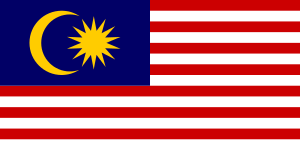 George Town, Penang, Malaysia[26] (20 November 2012)
See also
References
- ↑ "연령별 인구현황" (in Korean). rcps.egov.go.kr. Retrieved 2015-10-01.
- ↑ "Integrated Changwon launched 100 days". Herald Economy News. Retrieved Nov 17, 2010.
- 1 2 "2014. 6. 30. 기준 면적(지적)통계" (xlsx) (in Korean). Changwon City. 2014-07-08. Retrieved 2015-10-01.
- ↑ "Promotional Video". Changwon City Hall. Retrieved May 29, 2013.
- ↑ "Global Mega-City Changwon". Chosun News. Retrieved July 6, 2010.
- ↑ "History of Changwon". Changwon cityhall. Retrieved Nov 17, 2010.
- ↑ "City and Street Changwon blov". Seoul News. Retrieved April 5, 2010.
- ↑ "10th Ramsar Conference of Parties to the Convention opened in Changwon". Yonhap News. Retrieved October 28, 2010.
- ↑ "Nubija". YTN. Retrieved Oct 22, 2008.
- ↑ "Wansu-Park was elected the first mayor of Unified Changwon city.". Yonhap News. Retrieved Nov 16, 2010.
- ↑ "Unified Changwon launched". MBC. Retrieved Nov 16, 2010.
- ↑ "Changwon National Industrial Complex exceeded 2,000 companies.". Chosun News. Retrieved Nov 16, 2010.
- ↑ "평년값자료(1981−2010) 창원(155)". Korea Meteorological Administration. Retrieved 2011-05-21.
- ↑ "행정지도" (in Korean). Changwon City. Retrieved 2015-10-01.
- ↑ "Changwon GRDP 21 trillion won". Hankuk economy news. Retrieved Nov 16, 2010.
- ↑ "Changwon city schools". Gyeongsangnam-do Changwon Office of Education. Retrieved Nov 16, 2010.
- ↑ "History of Changwon National University". Changwon National University. Retrieved Nov 17, 2010.
- ↑ "History of Kyungnam University". Kyungnam University. Retrieved Nov 17, 2010.
- ↑ "Students of Kyungnam University". Kyungnam University. Retrieved Nov 17, 2010.
- ↑ "Korea Naval Academy". Korea Naval Academy. Retrieved Nov 17, 2010.
- ↑ "list of Changwon Department of Public Health Center.". Changwon Department of Public Health. Retrieved Nov 17, 2010.
- ↑ "New Ballpark Site for Expansion Baseball Club". Yonhap News Agency. Yonhap News. 2014-09-04. Retrieved 24 October 2014.
- ↑ "Baseball-South Korea league adds new team for 2013". Reuters. Reuters. February 10, 2011. Retrieved 24 May 2011.
- ↑ Official website (Korean)
- ↑ "Changwon Character Introduction". Archived from the original on September 24, 2008. Retrieved 2008-09-28.
- ↑ . About Changwon (20 November 2012). Retrieved on 2014-04-11.
External links
| Wikimedia Commons has media related to Changwon. |
| Wikivoyage has a travel guide for Changwon. |
- City government website
- City Mayors profile
- Gyeongnam Institute of Cultural Properties
- Changwon National Research Institute of Cultural Heritage
| Preceded by Busan |
Capital of Gyeongsangnam-do 1983- |
Succeeded by Incumbent |
