Victor, Colorado
| City of Victor, Colorado | |
|---|---|
| City | |
|
| |
| Nickname(s): City of Mines | |
| Motto: "City of Gold Mines"[1] | |
 Location in Teller County and the state of Colorado | |
| Coordinates: 38°42′35″N 105°8′27″W / 38.70972°N 105.14083°WCoordinates: 38°42′35″N 105°8′27″W / 38.70972°N 105.14083°W | |
| Country | United States |
| State | Colorado |
| County[2] | Teller County |
| Founded | 1891 |
| Incorporated | July 16, 1894[3] |
| Government | |
| • Type | Statutory city[2] |
| Area | |
| • Total | 0.27 sq mi (0.7 km2) |
| • Land | 0.27 sq mi (0.7 km2) |
| • Water | 0 sq mi (0 km2) |
| Elevation[4] | 9,708 ft (2,959 m) |
| Population (2010) | |
| • Total | 397[5] |
| • Density | 1,470.4/sq mi (567.7/km2) |
| Time zone | Mountain (MST) (UTC-7) |
| • Summer (DST) | MDT (UTC-6) |
| ZIP code[6] | 80860 |
| Area code(s) | 719 |
| FIPS code | 08-80865 |
| GNIS feature ID | 0204771 |
| Website | City of Victor, Colorado |

Victor is a statutory city in Teller County, Colorado, United States. Gold was discovered in Victor in the late 19th century, an omen of the future of the town. With Cripple Creek, the mining district became the second largest gold mining district in the country and realized approximately $10 billion of mined gold in 2010 dollars. It reached its peak around the turn of the century when there were about 18,000 residents in the town. Depleted ore in mines, labor strife and the exodus of miners during World War I caused a steep decline in the city's economy, from which it has never recovered. The population was 397 at the 2010 census. There is a resumed mining effort on Battle Mountain.
History
Gold discovery
Victor was founded in 1891, shortly after Winfield Scott Stratton discovered gold nearby. The town was named after the Victor Mine,[7] which may have been named for an early settler, Victor Adams. In 1892 Harry, Frank and Warren Woods founded the Mt. Rosa Mining, Milling and Land Company.[8][nb 1] Battle Mountain, located just above Victor, had the largest, most prolific mines in the mining district and the town became known as the "City of Mines." Victor officially became a city on July 16, 1894.[8] In 1894 the Woods brothers discovered gold when they began digging the foundation for a building, which resulted in the creation of the Gold Coin Mine. At that time 8,000 people lived in Victor.[8]
The town boomed as the surrounding Cripple Creek mining district quickly became the most productive gold mining district in Colorado.[9] Mines in Victor and Cripple Creek provided 21 million ounces of gold. In 2010, the value of the gold would have been more than $10 billion. The mining district, which hit its peak in 1900, became the 2nd largest gold district in the country's history.[10]
Although Victor's fame was overshadowed by that of its neighbor, Cripple Creek, many of the best gold mines of the Cripple Creek district were located at Victor, including Stratton's Independence Mine and Mill[8] and the Portland Mine. Half of Battle Mountain's gold was extracted by the Portland Mine, which was called the 'Queen of the District." Heavyweight boxing champion William Harrison "Jack" Dempsey was a mucker in the Portland Mine.[10]
Mine owners and investors lived in Cripple Creek, while most of the miners for the districts' 500 mines lived in Victor.[8][10]
Fire of 1899
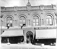
In August 1899 the entire business district was destroyed in a five-hour fire. The town had about 18,000 residents at the time.[8][11][12] As a result, many of the historic buildings date to 1899, including the St. Victor Roman Catholic church, the First Baptist Church of Victor, and the Victor Hotel.
Unionized workforce
The Western Federation of Miners (WFM) began to organize workers in a fight for shorter work days and standard wages.[13] The workforce became heavily unionized after the Western Federation of Miners conducted a significant strike in 1894. A subsequent strike in 1903 had such an impact that it came to be called the Colorado Labor Wars.[14] At this point, the amount of available ore to mine had declined significantly and mining in the district was further impacted by slow production as the result of violent strikes.[15]
The WFM's union hall in Victor still stands, with telltale bullet holes left intact. The building has structural problems and needs renovation.[16]
Mining decline
The town declined steadily in the 20th century, as the gold mines became worked out,[15] and the cost of mining rose relative to the price of gold (fixed at $20.67/troy ounce). Area miners enlisted during World War I, and the loss of workers created a steep decline in mining activity from which the area has not recovered.[17]
Gold mining increased in 1934 when the federal government raised the price of gold to $34/ounce, but gold mining was shut down during World War II as nonessential to the war effort. Some mines opened after the war, but all mines in the district closed by 1962.[18]
Resumed mining activity
The Cripple Creek & Victor Gold Mining Company formed in 1976 as a joint venture to restart mining in the district. From 1976 to 1989, the company produced 150,000 troy ounces (4,600 kg) of gold by reprocessing tailings and mining two small surface deposits. The Cripple Creek & Victor Gold Mining Company began the first large-scale open pit mining in the district in 1994.[19] In 1995 an open pit gold mining operation, which taps into "legendary" mines, began on Battle Mountain.[10] The Cresson mine open pits are located a few miles north of Victor. Mining continues at the Cripple Creek & Victor Gold Mine, under the ownership of AngloGold Ashanti,[18] producing about 250,000 troy ounces of gold in 2012,[20] in addition to several locally owned mines, all of which provide employment and revenue for the community.
 The Victor City Hall is one of several historic buildings that have been restored in downtown Victor.
 Gold mine in Victor, Colorado, around 1900
Geography
Victor is located at 38°42′35″N 105°8′27″W / 38.70972°N 105.14083°W (38.709609, -105.140859).[21] According to the United States Census Bureau for 2010, the city has a total area of 0.27 square miles (0.70 km2), all of it land.[5]
Climate
| Climate data for Victor, Colorado | |||||||||||||
|---|---|---|---|---|---|---|---|---|---|---|---|---|---|
| Month | Jan | Feb | Mar | Apr | May | Jun | Jul | Aug | Sep | Oct | Nov | Dec | Year |
| Record high °F (°C) | 57 (14) |
62 (17) |
68 (20) |
72 (22) |
77 (25) |
84 (29) |
92 (33) |
83 (28) |
79 (26) |
77 (25) |
66 (19) |
63 (17) |
92 (33) |
| Average high °F (°C) | 35.1 (1.7) |
37.2 (2.9) |
40.9 (4.9) |
47.2 (8.4) |
55.7 (13.2) |
66.9 (19.4) |
71.1 (21.7) |
69.2 (20.7) |
64.0 (17.8) |
54.2 (12.3) |
43.7 (6.5) |
35.9 (2.2) |
51.76 (10.98) |
| Average low °F (°C) | 13.6 (−10.2) |
13.8 (−10.1) |
17.2 (−8.2) |
23.3 (−4.8) |
31.7 (−0.2) |
41.0 (5) |
45.5 (7.5) |
45.0 (7.2) |
38.5 (3.6) |
29.4 (−1.4) |
21.7 (−5.7) |
14.5 (−9.7) |
27.93 (−2.25) |
| Record low °F (°C) | −27 (−33) |
−25 (−32) |
−14 (−26) |
−4 (−20) |
10 (−12) |
13 (−11) |
29 (−2) |
25 (−4) |
14 (−10) |
−4 (−20) |
−15 (−26) |
−21 (−29) |
−27 (−33) |
| Average precipitation inches (mm) | 0.32 (8.1) |
0.45 (11.4) |
1.09 (27.7) |
1.20 (30.5) |
1.77 (45) |
1.65 (41.9) |
4.90 (124.5) |
3.88 (98.6) |
1.55 (39.4) |
0.91 (23.1) |
0.58 (14.7) |
0.56 (14.2) |
18.86 (479) |
| Average snowfall inches (cm) | 5.5 (14) |
8.1 (20.6) |
15.2 (38.6) |
12.4 (31.5) |
7.0 (17.8) |
0.5 (1.3) |
0 (0) |
0 (0) |
2.4 (6.1) |
8.4 (21.3) |
8.4 (21.3) |
8.0 (20.3) |
75.8 (192.5) |
| Source: The Western Regional Climate Center[22] | |||||||||||||
Demographics
| Historical population | |||
|---|---|---|---|
| Census | Pop. | %± | |
| 1900 | 4,986 | — | |
| 1910 | 3,162 | −36.6% | |
| 1920 | 1,777 | −43.8% | |
| 1930 | 1,291 | −27.3% | |
| 1940 | 1,784 | 38.2% | |
| 1950 | 684 | −61.7% | |
| 1960 | 434 | −36.5% | |
| 1970 | 258 | −40.6% | |
| 1980 | 265 | 2.7% | |
| 1990 | 258 | −2.6% | |
| 2000 | 445 | 72.5% | |
| 2010 | 397 | −10.8% | |
| Est. 2015 | 389 | [23] | −2.0% |
2000
As of the census[25] of 2000, there were 445 people, 203 households, and 111 families residing in the city. The population density was 1,635.8 people per square mile (636.4/km²). There were 360 housing units at an average density of 1,323.3 per square mile (514.8/km²). The racial makeup of the city was 93.48% White, 0.22% African American, 2.25% Native American, 0.22% Asian, 2.02% from other races, and 1.80% from two or more races. Hispanic or Latino of any race were 6.52% of the population.
There were 203 households out of which 25.6% had children under the age of 18 living with them, 41.4% were married couples living together, 8.9% had a female householder with no husband present, and 45.3% were non-families. 33.0% of all households were made up of individuals and 7.4% had someone living alone who was 65 years of age or older. The average household size was 2.19 and the average family size was 2.84.
In the city the population was spread out with 24.3% under the age of 18, 7.4% from 18 to 24, 32.1% from 25 to 44, 28.5% from 45 to 64, and 7.6% who were 65 years of age or older. The median age was 38 years. For every 100 females there were 95.2 males. For every 100 females age 18 and over, there were 101.8 males.
The median income for a household in the city was $31,250, and the median income for a family was $34,375. Males had a median income of $38,750 versus $17,019 for females. The per capita income for the city was $17,242. About 14.0% of families and 18.4% of the population were below the poverty line, including 31.7% of those under age 18 and 5.0% of those age 65 or over.
2010
As of the census[25] of 2010, there were 397 people. The population density was 1,470.4 inhabitants per square mile (567.7/km2). There were 337 housing units at an average density of 1,248.1 per square mile.[5]
Arts and culture
Museums and other points of interest
Victor is in the heart of Colorado's gold country,[26] home to two of the major gold mines in the Cripple Creek mining district. Though the goldrush-era mines are closed, near the center of town the fortress-like remains of a wrought iron-gated mine entrance, shaft elevators (which carried the miners down), mine carts (now employed by the town as flower planters), barred tunnels, two outbuildings (an office overlooking the entrance and the building from which the miners set out), and other sites of interest from that era still stand. Several towering 'gallows frames', which house the antique elevator pulleys, can be seen on the hillsides. Victor has many mining and history related attractions:
- Gold Coin Mine[17]
- Lowell Thomas Museum[17][27]
- Victor Hotel[17]
- Victor Downtown Historic District, including the active First Baptist Church[17]
Victor also lies along the Gold Belt Tour National Scenic and Historic Byway.[28]
Arts festival
"Victor Celebrates the Arts" is a judged painting contest held on Labor Day weekend,[29] which began in 2000.
Photography book
A 2015 book, City of Mines, by Anderson & Low (ISBN 978-1907893773), depicts the buildings and scenery around the town without showing the people.[30]
Education
Students are served by the Cripple Creek-Victor High School.
See also
- Outline of Colorado
- Cripple Creek and Victor Narrow Gauge Railroad
- Gold Belt Tour National Scenic and Historic Byway
- Victor Downtown Historic District
Notes
- ↑ Harry and Frank Woods arrived in the Victor area in 1892 with their father Warren Woods. Warren, born in Ohio in 1834, "was the president of most of the Woods' enterprises." Frank managed the Woods Investment Company operations. Harry was a newspaper man before moving to Colorado; He was born in Illinois in 1859. In addition to the Gold Coin Mine and the Victor Bank Block, the Woods also owned or invested in the Pikes Peak Power Company, Golden Crescent Water and Light Company and the First National Bank of Victor. The power company sold power to Pueblo, Cripple Creek and Victor. In 1927 their "empired ended".[8]
References
- ↑ "City of Victor Colorado". City of Victor Colorado. Retrieved September 22, 2012.
- 1 2 "Active Colorado Municipalities". State of Colorado, Department of Local Affairs. Retrieved 2007-09-01.
- ↑ "Colorado Municipal Incorporations". State of Colorado, Department of Personnel & Administration, Colorado State Archives. 2004-12-01. Retrieved 2007-09-02.
- ↑ "US Board on Geographic Names". United States Geological Survey. 2007-10-25. Retrieved 2008-01-31.
- 1 2 3 "2010 Census" (PDF). U.S. Census Bureau. Retrieved May 22, 2013.
- ↑ "ZIP Code Lookup" (JavaScript/HTML). United States Postal Service. Retrieved 2008-01-07.
- ↑ "Profile for Victor, Colorado, CO". ePodunk. Retrieved September 22, 2012.
- 1 2 3 4 5 6 7 "History". Victor, Colorado. Retrieved May 22, 2013.
- ↑ Mark W. Davis, Randall K. Streufert (1990). Gold Occurrences of Colorado. Colorado Geological Survey, Resource Series 28. p. 28.
- 1 2 3 4 Philip Varney (4 July 2010). Ghost Towns of the Mountain West: Your Guide to the Hidden History and Old West Haunts of Colorado, Wyoming, Idaho, Montana, Utah, and. Voyageur Press. p. 63. ISBN 978-1-61060-090-3. Retrieved May 22, 2013.
- ↑ Alexandra Walker Clark (28 July 2011). Colorado's Historic Hotels. The History Press. p. 232. ISBN 978-1-60949-301-1. Retrieved May 22, 2013.
- ↑ "History". Victor Hotel. Retrieved May 22, 2013.
- ↑ Philip Varney (4 July 2010). Ghost Towns of the Mountain West: Your Guide to the Hidden History and Old West Haunts of Colorado, Wyoming, Idaho, Montana, Utah, and. Voyageur Press. p. 64. ISBN 978-1-61060-090-3. Retrieved May 22, 2013.
- ↑ William Philpott (1994). The Lessons of Leadville, Or, Why the Western Federation of Miners Turned Left (Monograph 10). Denver: Colorado Historical Society. ISSN 1046-3100.
- 1 2 Philip Varney (4 July 2010). Ghost Towns of the Mountain West: Your Guide to the Hidden History and Old West Haunts of Colorado, Wyoming, Idaho, Montana, Utah, and. Voyageur Press. pp. 63–65. ISBN 978-1-61060-090-3. Retrieved May 22, 2013.
- ↑ Deedee Correll (March 30, 2005). "Victor hall hanging by thread In 2014, the Hall was struck by lightning and burned. It is now just a shell.". The Gazette (accessed via HighBeam Research). Colorado Springs.
- 1 2 3 4 5 Philip Varney (4 July 2010). Ghost Towns of the Mountain West: Your Guide to the Hidden History and Old West Haunts of Colorado, Wyoming, Idaho, Montana, Utah, and. Voyageur Press. p. 65. ISBN 978-1-61060-090-3. Retrieved May 22, 2013.
- 1 2 "Cripple Creek Mining District Timeline". Cripple Creek & Victor Gold Mining Company. Retrieved May 22, 2013.
- ↑ Keith Dyas and Jerry Marcus (1998) The Cresson project, Engineering & Mining Jour., 6/1998, p.32KK-32OO.
- ↑ "Cripple Creek & Victor". AngloGold Ashanti - Cripple Creek & Victor Gold Mining Company. Retrieved May 22, 2013.
- ↑ "US Gazetteer files: 2010, 2000, and 1990". United States Census Bureau. 2011-02-12. Retrieved 2011-04-23.
- ↑ "Seasonal Temperature and Precipitation Information". Western Regional Climate Center. Retrieved March 27, 2013.
- ↑ "Annual Estimates of the Resident Population for Incorporated Places: April 1, 2010 to July 1, 2015". Retrieved July 2, 2016.
- ↑ "Census of Population and Housing". Census.gov. Retrieved June 4, 2015.
- 1 2 "American FactFinder". United States Census Bureau. Retrieved 2008-01-31.
- ↑ "Victor". Colorado Past and Present. Retrieved May 22, 2013.
- ↑ "Victor Lowell Thomas Museum". Victor, Colorado. Retrieved May 22, 2013.
- ↑ "Gold Belt Byway". US Department of Transportation. Retrieved May 22, 2013.
- ↑ "Victor Celebrates The Arts". Retrieved December 28, 2015.
- ↑ Dan Damon (December 12, 2015). "Colorado gold rush ghost town revisited". BBC. Retrieved December 28, 2015.
External links
- City of Victor website Portal style website, Government, Business, Library, Recreation and more
- City-Data.com Comprehensive Statistical Data and more about Victor
- CDOT map of the City of Victor
- Victor at GhostTowns.com
Municipalities and communities of Teller County, Colorado, United States | ||
|---|---|---|
| Cities | 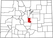 | |
| Town | ||
| CDPs | ||
| Unincorporated community | ||
| Ghost towns | ||
| Footnotes | ‡This populated place also has portions in an adjacent county or counties | |
