Zushi Station
Zushi Station 逗子駅 | |
|---|---|
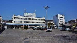 Zushi Station forecourt in January 2014 | |
| Location |
1 Zushi, Zushi-shi, Kanagawa-ken 249-0006 Japan |
| Operated by | ■ JR East |
| Line(s) | |
| Platforms | 3 |
| Tracks | 4 |
| Connections | Bus |
| Other information | |
| Website |
www |
| History | |
| Opened | 16 June 1889 |
| Traffic | |
| Passengers | 28,596 per day (FY2014) |
Zushi Station (逗子駅 Zushi-eki) is a railway station on the Yokosuka Line in Yokosuka, Kanagawa, Japan, operated by East Japan Railway Company (JR East).
Lines
Zushi Station is served by the Yokosuka Line and also by Shōnan-Shinjuku Line through services. It lies 8.4 kilometers from the junction at Ōfuna Station, and 57.8 kilometers from Tokyo Station.
The station is also used by rolling stock delivered from the J-TREC factory in Kanazawa-ku, Yokohama via a JR Freight connecting line immediately south of the station.[1]
Station layout
Zushi Station has an island platform and a side platform serving three tracks. Platform 1 is used for trains which originate or terminate at Zushi. The platforms are connected by two overpasses. The station has entrances on the north and south sides, designated "west" and "east" respectively. In August 2007, escalator and elevator facilities were completed and a new overpass was opened on the eastern (Higashi-Zushi) side. The west exit was moved somewhat to the west.
There is a Midori no Madoguchi staffed ticket office, automatic ticket vending machines, reserved ticket vending machines, automatic ticket gates, and automatic fare adjustment machines. Also, in the station, outside the ticket gates, there is a Newdays convenience store and a kōban (police box).
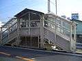 The former "west" entrance on the north side of the station in November 2004
 The new "west" entrance on the north side of the station in January 2014
Platforms
| 1 | ■ Yokosuka Line | for Ōfuna, Yokohama, Tokyo, (Sōbu Main Line) Chiba, Narutō, (Narita Line) Narita Airport, and (Uchibō Line) Kimitsu |
| ■ Shonan-Shinjuku Line | for Shibuya, Shinjuku, Ikebukuro, Ōmiya, and Utsunomiya | |
| 2 | ■ Yokosuka Line | for Ōfuna, Yokohama, Tokyo, (Sōbu Main Line) Chiba, Narutō, (Narita Line) Narita Airport, (Uchibō Line) Kimitsu,Yokosuka, and Kurihama |
| ■ Shonan-Shinjuku Line | for Shibuya, Shinjuku, Ikebukuro, Ōmiya, and Utsunomiya | |
| 3 | ■ Yokosuka Line | for Yokosuka, Kurihama, Ōfuna, Yokohama, Tokyo, (Sōbu Main Line) Chiba, Narutō, (Narita Line) Narita Airport, and (Uchibō Line) Kimitsu |
Adjacent stations
| « | Service | » | ||
|---|---|---|---|---|
| Yokosuka Line | ||||
| Kamakura | Local | Higashi-Zushi | ||
| Shonan-Shinjuku line | ||||
| Kamakura | Local | Terminus | ||
History
Zushi Station opened on June 16, 1889.[2] The present station building, the third building on this site was completed in March 1969. The station came under the management of JR East upon the privatization of the Japanese National Railways (JNR) on April 1, 1987. Shonan-Shinjuku Line services started on 1 December 2001.
Passenger statistics
In fiscal 2014, the station was used by an average of 28,596 passengers daily (boarding passengers only).[3] The passenger figures for previous years are as shown below.
| Fiscal year | Daily average |
|---|---|
| 2000 | 26,767[4] |
| 2005 | 26,946[5] |
| 2010 | 28,708[6] |
| 2014 | 28,596[3] |
Surrounding area
- Shin-Zushi Station (■ Keikyu Zushi Line)
- Seiwa Gakuin Junior & Senior High School
- Zushi Kasei Junior & Senior High School
See also
References
- Harris, Ken and Clarke, Jackie. Jane's World Railways 2008-2009. Jane's Information Group (2008). ISBN 0-7106-2861-7
- ↑ 郷田, 恒雄 (November 2012). "車扱列車を見てみよう!10" [Watching Carload Freight Trains (10)]. Japan Railfan Magazine. Vol. 52 no. 619. Japan: Kōyūsha Co., Ltd. pp. 76–79.
- ↑ Zushi Station information. Retrieved on 13 October 2008. (Japanese)
- 1 2 各駅の乗車人員 (2014年度) [Station passenger figures (Fiscal 2014)] (in Japanese). Japan: East Japan Railway Company. 2015. Retrieved 17 November 2015.
- ↑ 各駅の乗車人員 (2000年度) [Station passenger figures (Fiscal 2000)] (in Japanese). Japan: East Japan Railway Company. 2001. Retrieved 17 November 2015.
- ↑ 各駅の乗車人員 (2005年度) [Station passenger figures (Fiscal 2005)] (in Japanese). Japan: East Japan Railway Company. 2006. Retrieved 17 November 2015.
- ↑ 各駅の乗車人員 (2010年度) [Station passenger figures (Fiscal 2010)] (in Japanese). Japan: East Japan Railway Company. 2011. Retrieved 17 November 2015.
External links
| Wikimedia Commons has media related to Zushi Station. |
- Zushi Station information (Japanese)
Coordinates: 35°17′51.03″N 139°34′46.29″E / 35.2975083°N 139.5795250°E