Ōshū, Iwate
| Ōshū 奥州市 | |||
|---|---|---|---|
| City | |||
|
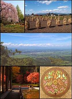
From top left; Spring in Mizusawa Park, the Autumn rice harvest in Isawa, Maesawa and the Kitakami River in Summer from Mt. Otowa, Autumn foliage at Fujiwara no Sato in Esashi and a manhole cover in Koromogawa | |||
| |||
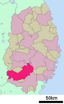 Location of Ōshū in Iwate Prefecture | |||
 Ōshū
| |||
| Coordinates: 39°8′40.1″N 141°08′20.9″E / 39.144472°N 141.139139°ECoordinates: 39°8′40.1″N 141°08′20.9″E / 39.144472°N 141.139139°E | |||
| Country | Japan | ||
| Region | Tōhoku | ||
| Prefecture | Iwate | ||
| Government | |||
| • -Mayor | Masaaki Aihara | ||
| Area | |||
| • Total | 993.30 km2 (383.52 sq mi) | ||
| Population (December 2015) | |||
| • Total | 119,002 | ||
| • Density | 120/km2 (300/sq mi) | ||
| Time zone | Japan Standard Time (UTC+9) | ||
| - Tree | Maple | ||
| - Flower | Sakura | ||
| - Bird | Green pheasant | ||
| Phone number | 0197-24-2111 | ||
| Address |
1-1 Ōtemachi, Mizusawa-ku, Ōshū-shi, Iwate-ken 023-8501 | ||
| Website | Official website | ||


Ōshū (奥州市 Ōshū-shi) is a city located in Iwate Prefecture, in the Tōhoku region of northern Japan. As of December 2015, the city had an estimated population of 119,002 and a population density of 120 persons per km². The total area was 993.30 square kilometres (383.52 sq mi). Ōshū is famous for its Maesawa Beef, numerous festivals, historic temples and shrines and Fujiwara no Sato, a theme park and movie lot based on the exploits of the Northern Fujiwaras in the 12th century. Many famous people have claimed Ōshū as their home including Ichiro Ozawa, the long-time leader of the Democratic Party of Japan.
Geography
Ōshū is located in the south-central portion of Iwate Prefecture, bordered by the Akita Prefecture to the west. At 993.35 square kilometers, Ōshū is the second largest community in Iwate Prefecture in terms of land area. The city lies in a fertile plain straddling the Kitakami River and rises to the Ōu Mountains in the west and the Kitakami mountains to the east. The city's highest point is Mt. Yakeishi-dake at 1,548 meters in the Ōu Mountains. The northern boundary is marked by the Isawa River while the Koromogawa River marks the southern border. Ishibuchi Dam creates a reservoir on the upper reaches of the Isawa River near Mt. Yakeishi-dake.
Neighboring municipalities
- Iwate Prefecture
- Akita Prefecture
History
The area of present-day Ōshū was part of ancient Mutsu Province, and has been settled since at least the Japanese Paleolithic period. Isawa is especially rich in Kofun Period remains from the 5th century. By the Nara period, Japanese hunters, trappers, settlers and itinerant missionaries were visiting and settling in this area, and coming into contact with the native Emishi people. In 729 Kokuseki-ji Temple was said to have been established by the Buddhist priest Gyōki in a mountainous area to the east of the Kitakami River in what is now Mizusawa. In 776 two separate attacks were launched by the Yamato dynasty against the Emishi with little success. In June 787 Emishi cavalry led by Aterui and More surprised and routed a larger force of Japanese infantry in the Battle of Subuse (located in what is now part of Mizusawa). Despite these successes the Emishi could not hold out against the Japanese and in 802 Aterui and More surrendered and were beheaded. That same year Sakanoue no Tamuramaro, established Fort Isawa in an attempt to keep the peace. Despite the victory the Japanese found if difficult to rule the territory directly. Six semi-autonomous districts were established along the Kitakami River. Eventually these came under the control of a powerful Emishi clan from Appi, the Abe clan. Early in the 11th century Abe no Yoritoki refused to pay taxes to the central government, led raiding parties south of the Koromo River, and generally ruled as an independent monarch. This led to the Zenkunen War (前九年合戦) or Early Nine-Years War (1050 - 1062) in which Minamoto no Yoriyoshi reinforced by Kiyohara no Takenori from Dewa Province defeated the Abe. The six semi-autonomous districts were then given to Kiyohara no Takenori. Corrupt administration by the Kiyohara led to the Gosannen War (後三年合戦) or Latter Three Years' War (1083 - 1087) in which Minamoto no Yoshiie subdued the Kiyohara
Fujiwara no Kiyohira, the founder of the Ōshū Fujiwara dynasty, was born in Fort Toyota which is now in the Iwayado area of Esashi. Around 1100 he moved to Hiraizumi where he and his descendants ruled for nearly a hundred years.
In 1348 a Zen Buddhist priest named Mutei Ryōshō founded Shōbō-ji Temple near Kokuseki-ji Temple in Mizusawa. It is the third head temple of the Sōtō sect of Zen Buddhism and boasts the largest thatched roof in Japan..
In the 16th century all of Ōshū became a part of the Date clan’s feudal domain ruled from Sendai, starting with Date Masamune. One of his retainers was a certain Juan Gotō who commanded Date Masamune's gun regiment at Osaka in 1614 and 1615. He was also a Christian and established a church in the Fukuwara area of Mizusawa. After Christianity was outlawed in 1623 he went into hiding to escape capture. Many foreign missionaries visited the area but finally in December 1623 a Jesuit Padre Diogo de Carvalho from Portugal was captured on the upper reaches of the Isawa River, sent to Sendai and forced to stand in the frozen Hirose River until he died in the early hours of what was then New Year's Day, namely February 19, 1624. There is a memorial to Juan Gotō in the Fukuwara area and many crypto-Christian remains can still be seen there.
The modern city of Ōshū was established on February 20, 2006, from the merger of the cities of Esashi and Mizusawa, the towns of Isawa and Maesawa, and the village of Koromogawa (all from Isawa District).
Education
- Graduate University for Advanced Studies – Iwate campus
- Iwate University – Ōshū campus
- Ōshū has 27 elementary schools, 12 middle schools and eight high schools, along with one special education school.
Transportation
Railway
- East Japan Railway Company (JR East) – Tōhoku Shinkansen
- East Japan Railway Company (JR East) – Tōhoku Main Line
Highway
- Tōhoku Expressway – Maesawa SA, Mizusawa IC
- Japan National Route 4
- Japan National Route 107
- Japan National Route 343 – Mizusawa Road Station
- Japan National Route 397
- Japan National Route 456
Sister city relations
 - Reutte, Tirol, Austria [1] since June 2011
- - Breitenwang, Tirol, Austria [1] since June 2011
 - Greater Shepparton, Victoria, Australia [1] since March 1979
Local attractions
- The sound of the Nambu Furin (wind chimes) at Mizusawa Station] in Ōshū is designated as one of the 100 Soundscapes of Japan by the Ministry of the Environment [2]
Noted people from Ōshū
- Gotō Shinpei – politician
- Saito Makoto – IJN admiral, politician and prime minister of Japan
- Shiina Etsusaburo – diplomat, foreign minister
- Keiji Kokuta – politician
- Eiichi Ohtaki – musician, singer-songwriter
- Tatsuya Yoshida - musician
- Shohei Otani – professional baseball player
- Oikawa Teruhisa – sumo wrestler
- Maedagawa Katsu – sumo wrestler
References
- 1 2 3 "International Exchange". List of Affiliation Partners within Prefectures. Council of Local Authorities for International Relations (CLAIR). Retrieved 21 November 2015.
- ↑ "100 Soundscapes of Japan". Ministry of the Environment. Retrieved 8 December 2015.
External links
| Wikimedia Commons has media related to Ōshū, Iwate. |
- Official website (Japanese)
| Core city | ||
|---|---|---|
| Cities | ||
| Isawa District | ||
| Iwate District | ||
| Kamihei District | ||
| Kesen District | ||
| Kunohe District | ||
| Ninohe District | ||
| Nishiiwai District | ||
| Shimohei District | ||
| Shiwa District | ||
| Waga District | ||