Shizukuishi, Iwate
| Shizukuishi 雫石町 | |||
|---|---|---|---|
| Town | |||
 | |||
| |||
 Location of Shizukuishi in Iwate Prefecture | |||
 Shizukuishi
| |||
| Coordinates: 39°41′N 140°59′E / 39.683°N 140.983°ECoordinates: 39°41′N 140°59′E / 39.683°N 140.983°E | |||
| Country | Japan | ||
| Region | Tōhoku | ||
| Prefecture | Iwate | ||
| District | Iwate | ||
| Government | |||
| • -Mayor | Masamitsu Ukaya (since October 2010) | ||
| Area | |||
| • Total | 609.01 km2 (235.14 sq mi) | ||
| Population (February 2014) | |||
| • Total | 17,277 | ||
| • Density | 29.4/km2 (76/sq mi) | ||
| Time zone | Japan Standard Time (UTC+9) | ||
| - Tree | Cryptomeria japonica | ||
| - Flower | Chrysanthemum | ||
| - Bird | Cettia diphone | ||
| Phone number | 019-692-2111 | ||
| Address | 5-1 Senkarita, Shizukuishi-chō, Iwate-gun, Iwate-ken 029-0595 | ||
| Website | Official website | ||


Shizukuishi (雫石町 Shizukuishi-chō) is a town located in Iwate District, Iwate Prefecture, Japan. As of February 2014, the town had an estimated population of 17,277 and a population density of 28.4 persons per km². The total area was 609.01 km².
Geography
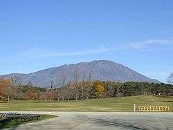
Shizukuishi is located in the Ōu Mountains of west-central Iwate Prefecture, bordering Akita Prefecture to the west. Mount Iwate, an active volcano, lies just to the north of Shizukuishi and dominates the landscape. The Ōu Mountains form the boundary to the west as well with Akita Komagatake, another active volcano, just across the border in Akita Prefecture. The downtown area is located where the Shizukuishi and Kakkonda Rivers meet. Gosho Lake was created in 1981 with the completion of Gosho Dam.
Neighboring municipalities
- Iwate Prefecture
- Akita Prefecture
History
The area of present-day Shizukuishi has been inhabited since the earliest times. Archaeologists have found remains dating to the Japanese Paleolithic period. The area come under the control of the Yamato dynasty during the early Heian period under the campaigns of Sakanoue no Tamuramaro, and was part of ancient Mutsu Province. The area was a battlefield during the Former Nine Years War and the Gosannen War. It eventually came under the control of the Nambu clan during the Edo period, who ruled Morioka Domain under the Tokugawa shogunate.
The villages of Shizukuishi, Gosho, Nishiyama and Omyojin within Minami-Iwate District were created on April 1, 1889 with the establishment of the municipality system. Kita-Iwate District and Minami-Iwate Districts merged to form Iwate District on March 29, 1896. Shizukuishi was raised to town status on December 23, 1940. On April 1, 1955, Shizukuishi merged with Gosho, Nishiyama and Omyojin, but lost a portion of its territory in a border adjustment with Morioka City on October 1 of the same year. The All Nippon Airways Flight 58 accident occurred over Shizukuishi on July 30, 1971.
Economy
The local economy is based on agriculture, forestry and seasonal tourism.
Transportation
Railway
- East Japan Railway Company (JR East) – Akita Shinkansen
- East Japan Railway Company (JR East) – Tazawako Line
Highway
Local attractions
In winter, numerous ski areas and resorts come to life. Koiwai Farm is a working dairy and tourist attraction. Every year in February it hosts a large snow festival.
This "remote farming village"[1] is known for its annual hemp festival every year in August which draws "crowds of sightseers".[2] Due to the town's rural nature, low income and low population Yoshiaki Tsutsumi, Japan's richest man at the time, was able to build a large ski area and hotel without the kind of "organized opposition of environmentalists" which stymied his plans elsewhere in Japan.[1]
References
- 1 2 "Japanese tycoon building top-notch ski, golf resort", The Chicago Daily Herald, August 25, 1991, section 4, page 2
- ↑ "Legal hemp in Shizuoka, bizarre drug laws" Reuters Newswire, August 25, 1998 Retrieved 31 August 2010.
External links
![]() Media related to Shizukuishi, Iwate at Wikimedia Commons
Media related to Shizukuishi, Iwate at Wikimedia Commons
- Official website (Japanese)
| Core city | ||
|---|---|---|
| Cities | ||
| Isawa District | ||
| Iwate District | ||
| Kamihei District | ||
| Kesen District | ||
| Kunohe District | ||
| Ninohe District | ||
| Nishiiwai District | ||
| Shimohei District | ||
| Shiwa District | ||
| Waga District | ||