Advanced Landing Ground (ALG) was the term given to the temporary advance airfields constructed by the Allies during World War II during the liberation of Europe. They were built in the UK prior to the invasion and thereafter in northwest Europe from 6 June 1944 to V-E Day, 7 May 1945.
Unlike the permanent airfields built in the United Kingdom and designed for the strategic bombardment of Germany, the tactical combat airfields on the continent were temporary, often improvised airfields to be used by the tactical air forces to support the advancing ground armies engaged on the battlefield. Once the front line moved out of range for the aircraft, the groups and squadrons moved up to newly built ALGs closer to the ground forces and left the ones in the rear for other support uses, or simply abandoned them.
Overview
When the Allies invaded Normandy on D-Day, Royal Air Force Airfield Construction Service engineers were among those in the initial assault waves. Their mission was to rapidly construct forward operating airfields, known as Advanced Landing Grounds (ALGs), on the European continent. As the Allied armies advanced across France and into Germany, several hundred airfields were built or rehabilitated for use by the allied air forces.
For security reasons, the airstrips were referred to by a coded number instead of location. In the United Kingdom, USAAF installations were identified by three digit (AAF) numbers ranging from AAF-101 to AAF-925. After D-Day, continental airfields in the European Theater of Operations (ETO) were also assigned coded numbers. American airfields were given A-, Y-, or R-, prefixes and numbered consecutively from 1 to 99. Both "A" and "Y" designated airfields could be found in France, however many "Y" fields would also be in France, as well as the Netherlands; Belgium and occupied areas of Germany. "R" coded fields were usually located in occupied Germany. British airfields on the continent were also consecutively numbered, but with a B-prefix.
The numbering system for airfields was sequentially assigned as airfields were allocated, not by location or by date of operational use. A-1, Saint Pierre du Mont, was declared operational on 13 June 1944; A-3 Cardonville on 14 June. However A-2, Cricqueville-en-Bessin, was declared operational a few days later on 19 June.
Also many of these airfields had no combat air group or squadron attached to them. They were designed for casualty evacuation and supply transport and consisted of a quickly built runway manned only by a small complement of station personnel with little or no infrastructure other than tents. As the ground forces moved east, wounded would be sent to the airfield to be picked up by C-47s and taken to hospitals in England or other rear areas. Also supplies would be airlifted to the fields and unloaded, to be quickly transported to the front line units. These were normally known as S&E Fields (Supply and Evacuation).
Once completed, airfields were usually utilized by the combat groups or squadrons within a day or so of being declared operational for military use by the IX Engineering command engineers. They would be used for perhaps a few days to a week, to several months, depending on the location, use, and operational requirements. Once the combat units moved up to the next assigned ALG, they could be utilized as S&E Fields, or deconstructed quickly and abandoned, with the land being released back to the landowners or civil authorities in the area.
Construction

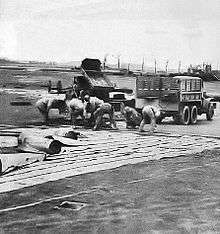
A USAAF Engineer clearing out the wreckage of a destroyed
Luftwaffe Bf 109 aircraft at an ALG, with a
P-38 Lightning flying overhead on landing approach
The mission for constructing ALGs was placed in the hands of the Airfield Construction Service of 2TAF, Royal Air Force, whilst the USAAF's Ninth Air Force and its specially created engineering arm, the IX Engineer Command, were responsible for ALG's in the US sector of operations. Each aviation engineer battalion in the command (of a total of sixteen) was composed of sufficient men and equipment to quickly construct an airfield or landing ground for a single tactical fighter or bomb group unit.[1]
ALGs were selected in two ways. First, existing enemy military or civilian airfields which were captured as the ground forces advanced were noted by engineers assigned to ground units. Second, engineers noted areas in grid locations where an airfield was desired, that had flat terrain, good land drainage, and where an airfield could be constructed quickly.[1]
Captured airfields could be restored for use as advanced landing field in one to three days depending upon the amount of drainage and the number of mines and booby traps encountered.[1]
Dry-weather advanced landing fields were constructed by a single battalion at a favorable site in flat terrain in from one to three days, including time for reconnaissance. At less favorable sites, where more clearing and grading were required, or all-weather fields which also needed additional infrastructure, the time varied from three to ten days.[1]
ALGs were equipped with an access road that was connected to the existing road infrastructure; a dump for supplies, ammunition, and gasoline drums, along with a drinkable water and a minimal electrical grid for communications and station lighting. Tents were used for billeting and also for support facilities. Time was the all-important factor and ALGs serve its purpose if available for only a few days. As the forward area became the rear area, an advanced landing field could be improved for medium bomber use, but initially they primarily served fighter and transport groups.[1]
Based on the experience obtained in the North African and Italian Campaigns, fighter groups required an airfield 120 feet x 3600 feet long, and fighter-bomber groups required fields 120 feet x 5000 feet long. Medium bomb groups required 120 feet x 6000 feet runways.[1]
Runway types
Instead of using rough, unimproved dirt strips, engineers used surfacing material necessary to strengthen the soil to support the weight of the aircraft and as a measure of insurance against the wet weather. Airfields were initially single runway landing strips which were laid down east–west (09/27) unless local conditions dictated a different runway direction.[1]
ALGs laid in the UK were of Sommerfeld Tracking a form of stiffened steel wire mesh.
- Square-Mesh Track (SMT)[2]
The surfacing material selected for the building of advanced landing grounds during the first weeks after the Normandy invasion was known as square-mesh track (SMT). SMT, a British development, was material composed of heavy wire joined in three-inch squares. It was chosen over other surfacing materials because it was very lightweight, allowing sufficient quantities to be transported across the English channel on over-tasked landing craft. Easily workable, a SMT landing mat for fighters could be laid like a carpet in about one week.
- Prefabricated Hessian (PBS)[2]
After the initial batch of airfields was completed using SMT, the Army aviation engineers switched almost exclusively to another surfacing material known as prefabricated hessian (burlap) surfacing (PBS). Light and easily transportable, PBS did not create the dust problem encountered with SMT fields. Made of an asphalt-impregnated jute delivered in rolls 300 feet in length and 36 inches or 43 inches in width, PBS was laid in overlapping layers to produce a dust-free fair weather surface. It was also common to build airstrips using both SMT and PBS, laying SMT on top.
- Pierced Steel Plank (PSP)[2]
To provide an all season durable airfield for the RAF's 2TAF and the USAF Ninth Air Force's medium and light bombers, a third type of surfacing material known as pierced steel plank (PSP), or Marsden Matting was introduced on the Normandy bridgehead in July 1944. It consisted of 10-foot-long (3.0 m), 15-inch-wide (380 mm) steel planks joined together and laid perpendicular to the line of flight. Long used in other theaters, PSP would have been ideal for all airfields on the continent, but its limited availability and greater weight made this impractical. Moreover, because of supply problems, construction of even a PSP fighter-bomber field could take a month or longer, while similar PBS and SMT fields could be constructed in two weeks and one week, respectively.
In addition, Sod and Earth runways were built for Emergency Landing Strips (ELS) and Refueling and Rearming Strips (R&R). Captured airfields contained a wide variety of runways, most commonly Asphalt; Concrete; Macadam or Tar-Penetrated Macadam.[1]
Airfield types
There were five main types of airfields built by the USAAF combat engineers on the continent. These were:
- Emergency Landing Strips (ELS)[3]
Consisted of a rough, graded runway approximately 2000 feet long to provide a place for emergency belly-landings of damaged aircraft.
- Supply and Evacuation (S&E)[3]
Usually a rough graded runway near the front line or an airfield in the rear that was used by C-47s for transport of casualties to the rear, or delivery of supplies and munitions to the front line.
- Refueling and Rearming (R&R)[3]
Consisted of a runway and an aircraft marshalling area on each end of the runway. It was designed to provide an airfield near the front lines upon which aircraft based in rear areas could land, be refueled and rearmed, and take off again on a mission without having to return to their home field in the rear. Also could be used for dispersal or for when services other than refueling or rearming was required. These airfields could be expanded into advance landing grounds by the addition of dispersal and other station facilities. Generally if an R&R strip was built, it would be sited wherever possible with a view to further expand it later into an ALG.
- Advanced Landing Grounds (ALG)[3]
An advanced landing ground could be constructed as such from the beginning or by development from an R&R Strip by the addition of dispersal facilities, expansion of the road network and other additions to the station and technical area in order for it to be used over an extended period of time.
- Tactical Air Depots (TAD)[3]
A number of ALGs were expanded into tactical air depots by the addition of hangars, shops, more dispersal hardstands, roads, and other facilities. Some were developed from the beginning.
Deployment
IX Engineering Command putting down a Pierced Steel Planking (PSP) Runway at an Advanced Landing Ground under construction
Four main designations were given to ALGs on the European Continent:
- "A" ALGs were located in France. They were constructed and used by Ninth Air Force units during the Invasion of Normandy (6 June – Mid July 1944) and during Operation Cobra, the breakout from Normandy, starting on 25 July 1944 until 25 August 1944. Those in Normandy were mostly decommissioned after their combat use, however others in Central France were used in various non-combat roles until the end of the war.[3]
- "B" ALGs were built by American or British combat engineers for Royal Air Force use. Some of these were also used by USAAF Troop Carrier Groups and Command and Control organizations.[3]
- "Y" ALGs were initially located in Southeastern France, built by Twelfth Air Force engineers as part of Operation Dragoon, the invasion of Southern France. Initially uncoded, they were given "Y" designations when they came under IX Engineering Command control in late 1944. ALGs were also coded "Y" in Northeastern France, Belgium; The Netherlands and Occupied Germany, after "A" coding reached 99 November 1944.[3]
- "R" ALGs were located in Occupied Germany. Many more were constructed than are listed here, consisting primarily of Supply and Evacuation airfields either laid down quickly in agricultural areas or on captured Luftwaffe airfields. "R" coding began after Y-coding reached 99 in April 1945.[3]
An unforeseen development was the extraordinary demand for transport, supply, and evacuation fields as the Allied armies pushed past Paris toward the German frontier. In late 1944, supplies could not keep pace with U.S. General Dwight D. Eisenhower's forces, and to help lessen the supply shortage airfields for C-47 Skytrain cargo planes became a priority. Bringing in ammunition of all types and especially gasoline on the trip to the ALGs on the continent, the C-47s on the return trip evacuated wounded to the rear.[1]
By 15 September 1944, IX Engineer Command had placed over eighty ALG airfields in operation, while British engineers had constructed 76 airfields in their zone. In Southern France, another twenty or so fields had been built by American engineers from Twelfth Air Force from the Mediterranean Theater of Operations (MTO). In October these uncoded airfields were assigned to the ETO and given ALG code numbers.[1]
The stabilization of the front lines in the Netherlands, Belgium, and eastern France in mid-September 1944, which would last into the new year, allowed aviation engineers a chance to reorganize and prepare for the upcoming winter season. As expected, they could not build new PHS and SMI airstrips during the fall rain and winter snow seasons because of the moist ground. Besides concrete, the American-made PSP was the only available surfacing material that could be laid down during this inclement weather in Europe.[1]
To keep the supply lines open, selected airfields in Belgium and France were therefore "winterized" with PSP. Because of the limited supply of PSP, however, only a limited number of airfields could be winterized, making it necessary to base two group sized units per airfield. But sufficient fighter-bomber and medium bomber airfields were completed that winter to ensure 2TAF and Ninth Air Force aircraft could continue flying combat missions.[1]
The major problem affecting airfield construction in early 1945 was not the surprise German Ardennes counteroffensive (which caused the abandonment on only one airfield – Y-39, Haguenau). Rather, an early February thaw threatened to make airfields inoperable due to the mud and water. Using local civilian labor, engineers performed extensive maintenance on the threatened airfields and successfully resolved the crisis[1]
The renewed allied offensive in early 1945, following the Battle of the Bulge, was supported in earnest by the building of tactical airfields in occupied Germany. Trier (Y-57), became the first operational tactical American airfield on German soil on 10 March 1945. When a crossing over the Rhine River was spearheaded at Remagen, Germany, a supply and evacuation strip was quickly set up to support the bridgehead. As Allied tank columns struck out rapidly into the heartland of Germany, the airfield "clutches" of the Ninth Air Force's tactical air commands moved east of the Rhine river within range of virtually any target in Germany.[1]
Scores of former Luftwaffe sod and hard surfaced airfields were captured in the lightning advance through Central Germany, virtually undamaged, lessening the requirement for SMT, PHS, and PSP prefabricated surfacing. The relative lack of German military opposition in late March, April and May 1945 lessened the need for close air support and produced a greater demand for supply airstrips to keep the offensive moving. Every opportunity was used to clear captured German airfields for use along the armies' route, allowing C-47s and other transports to land with food, gas, and ammunition. The supply effort received top airfield priority. By V-E Day, 9 May 1945, 76 of the 126 airfields made operational east of the Rhine river were strictly supply and evacuation fields.[1]
Summary
USAAF Engineers constructed or rehabilitated over 280 continental airfields in the ETO from D-Day to V-E Day. In the summer months that followed, a few new airfields were constructed, but the vast majority were abandoned and turned over to local landowners or civil governments. Throughout Western Europe, as well as the airfields built by Twelfth and Fifteenth Air Forces in the MTO, a significant number were developed into permanent, civilian airports or NATO military bases after the war.[1]
The airfield coding system remained in effect until after the Japanese surrender in the Pacific, when, on 14 September 1945, the system was officially discontinued. Thereafter, airfields were referenced by their geographic name.[1]
Airfields
Only active combat ALGs are shown. Dedicated S&E, Liaison, Transport, and other non-combat airfields are not listed. Runway types are listed as follows:
- ASP Asphalt
- BRK Brick
- CON Concrete
- ETH Compressed Earth
- MAC Macadam
|
- PHS Prefabricated Hessian Surfacing
- SMT Square-Mesh Track
- SOD Sod
- PSP Pierced Steel Planking
- TAR Tar-Penetrated Macadam
|
United Kingdom (Kent)
Advanced Landing Grounds were built in Kent during 1943 and 1944 for several reasons. The first being a requirement by the allies to station short-range fighters close to the English Channel coast so missions could be undertaken to attack enemy coastal fortifications; road and rail networks and other military targets in Occupied France prior to the invasion of Normandy. Also construction of the ALGs provided necessary engineering and construction training as well as providing practical experience in the development of forward airfields which would be necessary on the Continent after the invasion. The ALG's laid down in Kent had two runways, while the ones laid down in France after the invasion generally had only one strip laid down east-west for speed of construction
Due to their temporary nature, the airfields were torn up and salvageable components were re-used on new ALGs in France after the assigned units were moved forward onto French ALGs after the invasion of Normandy.
Airfields in France used in support of the invasion and establishment of Allied forces in Normandy, France, during Operation Overlord and the immediate aftermath, 6 June—24 July 1944
- First USAAF Airfield in Liberated France.
- Located: 49°23′02″N 001°20′00″W / 49.38389°N 1.33333°W / 49.38389; -1.33333 (ELS Poupeville)
- Established: 6 June 1944: Closed: (Undetermined)
- Runway: 2000x100 SOD (05/23)
- Emergency Landing Strip[1]
- Located: 49°23′27″N 000°56′41″W / 49.39083°N 0.94472°W / 49.39083; -0.94472 (A-1 Saint-Pierre-du-Mont)
- Opened: 13 June 1944 Closed: 5 September 1944
- Runway: 5000x120, SMT, (09/27)[1]
- Used by:[4]
- 366th Fighter Group, 17 June – 24 August 1944 (P-47)
- 401st Fighter Squadron, 24 July-15 August 1944 (P-38)
- Located: 49°21′57″N 001°00′26″W / 49.36583°N 1.00722°W / 49.36583; -1.00722 (A-2 Cricqueville-en-Bessin)
- Opened: 16 June 1944 Closed: 15 September 1944
- Runway: 5000x120, SMT/ETH, (17/35)[1]
- Used by:[5]
- 354th Fighter Group, 22 June – 13 August 1944 (P-51)
- 367th Fighter Group, 14 August – 4 September 1944 (P-38)
- Located: 49°21′17″N 001°02′37″W / 49.35472°N 1.04361°W / 49.35472; -1.04361 (A-3 Cardonville)
- Opened: 14 June 1944 Closed: 1 September 1944
- Runway: 5000x120, SMT (15/33)[1]
- Used by:[5]
- 368th Fighter Group, 20 June – 23 August 1944 (P-47)
- 370th Fighter Group, 24 July – 15 August 1944 (P-38)
- Located: 49°20′40″N 000°58′48″W / 49.34444°N 0.98000°W / 49.34444; -0.98000 (A-4 Deux-Jumeaux)
- Opened: 30 June 1944 Closed: 15 September 1944
- Runway: 5000x120, SMT (11/29)[1]
- Used by:[4][5]
- 48th Fighter Group, 18 June – 29 August 1944 (P-47)
- 107th Tactical Reconnaissance Squadron, 28 June-5 July 1944 (P-51/F-5)
- 485th Fighter Squadron, 24 July-15 August 1944 (P-38)
- Located: 49°14′12″N 000°58′59″W / 49.23667°N 0.98306°W / 49.23667; -0.98306 (A-5 La Chapelle-en-Juger)
- Opened: 5 July 1944 Closed: 9 July 1944
- Runway: 5000x120, SMT (06/24)[1]
- Used by:[5]
- 404th Fighter Group, 6 July – 29 August 1944 (P-47)
- Located: 49°25′16″N 001°18′16″W / 49.42111°N 1.30444°W / 49.42111; -1.30444 (A-6 Beuzeville-la-Bastille)
- Established 7 June 1944. Opened: 12 June 1944 Closed: 18 September 1944
- Runway: 5000x120, SMT (05/23)[1]
- Used by:[5]
- 371st Fighter Group, – 18 June September 1944 (P-47)
- 367th Fighter Group, 22 July – 14 August 1944 (P-38)
|
- Located: 49°15′42″N 000°53′29″W / 49.26167°N 0.89139°W / 49.26167; -0.89139 (A-9 Le Molay-Littry)
- Opened: 30 June 1944 Closed: 5 October 1944
- Runway: 4000x120, SMT (04/22)[1]
- Used by:[4][5]
- 67th Tactical Reconnaissance Group, July–August 1944 (F-4/P-38; F-5/P-51)
- 12th Tactical Reconnaissance Squadron, 5 July-11 August 1944 (F-5/P-51)
- Located: 49°17′01″N 001°05′54″W / 49.28361°N 1.09833°W / 49.28361; -1.09833 (A-11 Saint-Lambert)
- Opened: 5 August 1944 Closed: 11 September 1944
- Runway: 5000x120, PHS (05/23)[1]
- Used by:
- 474th Fighter Group, 6–29 August 1944 (P-38)
- Located: 49°10′32″N 000°47′24″W / 49.17556°N 0.79000°W / 49.17556; -0.79000 (A-12 Lignerolles) (abandoned)
- Opened: 18 July 1944 Closed: 4 November 1944[1]
- Runway: 5000x120, PHS (07/25)
- Used by:[5]
- 362d Fighter Group, 2 July – 10 August 1944 (P-47)
- 365th Fighter Group, 15 August – 3 September 1944 (P-47)
- Located: 49°17′27″N 000°44′59″W / 49.29083°N 0.74972°W / 49.29083; -0.74972 (A-13 Tour-en-Bessin)
- Opened: 28 July 1944 Closed: 2 December 1944
- Runway 1: 5000x120, PSP (12/30)[1]
- Runway 2: 5000x120, PSP (01/19)
- Used by:[5]
- 373d Fighter Group, 19 July – 19 August 1944 (P-47)
- 406th Fighter Group, 5–17 August 1944 (P-47)
- 394th Bombardment Group, 25 August – 18 September 1944 (B-26)
- Located: 49°21′49″N 000°52′26″W / 49.36361°N 0.87389°W / 49.36361; -0.87389 (A-21 Saint-Laurent-sur-Mer)
- Opened: 8 June – 25 August 1944
- Runway: 3400x120, ETH (11/28)[1]
- Used as: Casuality evacuation and transport Airfield (IX Service Command)[3]
- A-21 memorial and information webpage
- Located: 49°21′15″N 000°49′41″W / 49.35417°N 0.82806°W / 49.35417; -0.82806 (A-22 Colleville-sur-Mer)
- Opened: 13 July-4 November 1944
- Runway: 3750x120, PBS (09/27)[1]
- Used as: Transport Airfield[3]
|
Cotentin Peninsula/Brittany Breakout
- Located: 48°39′50″N 001°24′09″W / 48.66389°N 1.40250°W / 48.66389; -1.40250 (ELS Avranches)
- Established: 8 August 1944: Closed: (Undetermined)
- Runway: 3600x120 SOD (05/23)
- Emergency Landing Strip[1]
- Located: 49°28′56″N 001°18′27″W / 49.48222°N 1.30750°W / 49.48222; -1.30750 (A-7 Azeville)
- Opened: 24 June 1944 Closed: 15 September 1944
- Runway: 3600x120, SMT (08/26)[1]
- Used by:[5]
- 365th Fighter Group, 28 June – 15 August 1944 (P-47)
- 363d Fighter Group, August–September 1944 (P-51)
- Located: 49°23′34″N 001°25′07″W / 49.39278°N 1.41861°W / 49.39278; -1.41861 (A-8 Picauville)
- Opened: 26 June 1944 Closed: 15 September 1944
- Runway: 5000x120, PHS (07/25)[1]
- Used by:[5]
- 405th Fighter Group, 30 June – 14 September 1944 (P-47)
- Located: 49°18′18″N 001°10′46″W / 49.30500°N 1.17944°W / 49.30500; -1.17944 (A-10 Carentan)
- Opened: 16 June 1944 Closed: 4 November 1944
- Runway: 5000x120, PHS (08/26)[1]
- Used by:[4][5]
- 50th Fighter Group, 25 June – 16 August 1944 (P-47)
- 392d Fighter Squadron, 22 July-14 August 1944 (P-38)
- Located: 49°20′17″N 001°22′39″W / 49.33806°N 1.37750°W / 49.33806; -1.37750 (A-14 Cretteville)
- Opened: 4 July 1944 Closed: 5 September 1944
- Runway: 5000x120, (3600 PHS/1400 ETH) (04/22)[1]
- Used by:[5]
- 358th Fighter Group, 3 July – 14 August 1944 (P-47)
- 406th Fighter Group, 17 August – 4 September 1944 (P-47)
- Located: 49°39′03″N 001°28′31″W / 49.65083°N 1.47528°W / 49.65083; -1.47528 (A-15 Maupertus-sur-Mer)
- Now: Cherbourg - Maupertus Airport or Aéroport de Cherbourg – Maupertus (IATA: CER, ICAO: LFRC)
- Opened: 4 July 1944 Closed: 22 December 1944
- Runway 1: 6000x120, PSP (11/29)[1]
- Runway 2: 5000x120, PSP (17/35)
- Used by:[4][5]
- 363d Fighter Group, 9 July – August 1944 (P-38)
- 387th Bombardment Group, 22 August – 18 September 1944 (B-26)
- 422d Night Fighter Squadron, 25 July – 28 August 1944 (P-61)
- Located: 49°22′05″N 001°13′18″W / 49.36806°N 1.22167°W / 49.36806; -1.22167 (A-16 Brucheville)
- Opened: 2 August 1944 Closed: 5 September 1944
- Runway: 5000x120, (3600 PHS/1400 ETH) (07/25)[1]
- Used by:[5]
- 36th Fighter Group, 4 July – 25 August 1944 (P-47)
- Located: 49°16′55″N 001°17′50″W / 49.28194°N 1.29722°W / 49.28194; -1.29722 (A-17 Méautis)
- Opened: 17 August 1944 Closed: 7 September 1944
- Runway: 5000x120, (3600 PHS/1400 ETH) (10/28)[1]
- Used by:[5]
- 50th Fighter Group, 16 August – 4 September 1944 (P-47)
- Located: 49°13′04″N 001°09′11″W / 49.21778°N 1.15306°W / 49.21778; -1.15306 (A-18 Saint-Jean-de-Daye)
- Opened: 29 August 1944 Closed: 9 September 1944
- Runway: 5000x120, (3600 PHS/1400 ETH) (06/24)[1]
- Emergency Landing/Refueling Field[3]
- A-19 Saint-Georges d' Elle (50) (La Vieille), France
- Located: 49°09′36″N 00°58′36″W / 49.16000°N 0.97667°W / 49.16000; -0.97667 (A-19 Saint-Pierre-la-Vieille)
- Opened: 14 August 1944 Closed: 7 September 1944
- Runway: 5000x120, (3600 PHS/1400 ETH) (01/19)[1]
- Used by:[5]
- 370th Fighter Group, 15 August – 6 September 1944 (P-38)
- Located: 49°12′08″N 001°30′29″W / 49.20222°N 1.50806°W / 49.20222; -1.50806 (A-20 Lessay)
- Now: Lessay Airport (IATA: XDR, ICAO: LFOM)
- Opened: 25 August 1944 Closed: 28 September 1944
- Runway 1: 6000x120, PSP (06/24)[1]
- Runway 2: 5000x120, PSP (12/30)
- Used by:[5]
- 323d Bombardment Group, 26 August – 21 September 1944 (B-26)
|
- Located: 49°39′51″N 001°41′38″W / 49.66417°N 1.69389°W / 49.66417; -1.69389 (A-23 Querqueville)
- Opened: 6 July-8 August 1945
- Runway: 4600x120, PSP (10/28)[1]
- Used by: Detachment, 27th Air Transport Group (ATC)[3]
- Located: 49°25′42″N 001°28′33″W / 49.42833°N 1.47583°W / 49.42833; -1.47583 (A-24 Biniville)
- Opened: 17 July-21 August 1944
- Runway: 3600x120, ETH (04/22)[1]
- Used by: Detachment, 125th Liaison Squadron[3]
- Located: 49°18′06″N 001°34′28″W / 49.30167°N 1.57444°W / 49.30167; -1.57444 (A-25 Bolleville)
- Opened: 7 August 1944 – 3 March 1945
- Runway: 3932x120, SMT & PBS (11/29)[1]
- Used as: Transport Airfield[3]
- Located: 49°14′34″N 001°23′44″W / 49.24278°N 1.39556°W / 49.24278; -1.39556 (A-26 Gorges)
- Opened: 16 August 1944 Closed: 28 September 1944
- Runway: 6000x120, PSP (07/25)
- Used by:
- 397th Bombardment Group, – 11 August September 1944 (B-26)
- Located: 48°04′19″N 001°43′56″W / 48.07194°N 1.73222°W / 48.07194; -1.73222 (A-27 Rennes/St-Jacques)
- Now: Rennes - Saint-Jacques Airport (IATA: RNS, ICAO: LFRN)
- Captured 7 August 1944 Opened: 10 August 1944 Closed: 30 November 1944
- Runway 1: 5593x260, CON (10/28)
- Runway 2: 4676x260, CON (14/32)
- Used by:
- 362d Fighter Group, 10 August – 19 September 1944 (P-47)
- 10th Reconnaissance Group, 11 August – September 1944 (P-38/F-5; P-51/F-6)
- Located: 48°31′25″N 001°19′24″W / 48.52361°N 1.32333°W / 48.52361; -1.32333 (A-29 Saint-James)
- Opened: 14 August 1944 Closed: 28 September 1944
- Runway: 5000x120, PHS (13/31)
- Used by:
- 373d Fighter Group, 19 August – 19 September 1944 (P-47)
- Located: 48°37′42″N 001°24′27″W / 48.62833°N 1.40750°W / 48.62833; -1.40750 (A-30 Courtils) (approximately)
- Opened: 13 August-5 September 1944
- Runway: 3600x120, ETH (10/28)[1]
- Used as: Transport Airfield[3]
- Located: 48°04′52″N 002°11′46″W / 48.08111°N 2.19611°W / 48.08111; -2.19611 (A-31 Gaël)
- Captured: 10 August 1944 Opened: 11 August 1944 Closed: 28 September 1944
- Runway: 4500x120, SOD/ETH (08/26)
- Used by:
- 354th Fighter Group, 13 August – 17 September 1944 (P-51)
- A-32 Nantes/Chateau-Bougcn, France
- Construction Cancelled[3]
- Located: 47°43′10″N 002°43′25″W / 47.71944°N 2.72361°W / 47.71944; -2.72361 (A-33 Vannes)
- Now: Meucon Airport (IATA: VNE, ICAO: LFRV)
- Captured 10 August 1944 Opened: 29 August 1944 Closed: 20 June 1945
- Runway 1: 6000X200, CON/TAR (13/31)
- Runway 2: 4400x200, CON/TAR (04/22)
- Used by:
- 425th Night Fighter Squadron, 18 August – 11 September 1944 (P-61)
- Located: 48°36′03″N 003°49′00″E / 48.60083°N 3.81667°E / 48.60083; 3.81667 (A-51 Morlaix)
- Opened: 1 September-8 November 1944
- Runway: 40500x120 CON (05/23)[1]
- Use: Transport Airfield[3]
|
Northern France Campaign
The US marks the "Northern France Campaign" from the breakout following the invasion of Normandy to September 1944.
Drive to the Seine River
- Located: 48°32′42″N 001°29′49″W / 48.54500°N 1.49694°W / 48.54500; -1.49694 (A-28 Pontorson)
- Opened: 10 August 1944 Closed: 28 September 1944
- Runway: 5000x120, (3600 PHS/1400 ETH) (08/26)
- Used by:
- 358th Fighter Group, 14 August – 14 September 1944 (P-47)
- Located: 48°00′27″N 000°11′54″E / 48.00750°N 0.19833°E / 48.00750; 0.19833 (A-35 Le Mans)
- Captured: 12 August 1944 Opened: 3 September 1944 Closed: 20 November 1944
- Runway: 5000x120, PHS (14/32)[1]
- Used by:[5]
- 36th Fighter Group, 25 August – September 1944 (P-47)
- 440th Troop Carrier Group, 30 September – 2 November 1944 (C-47)
- Located: 48°24′45″N 000°48′41″W / 48.41250°N 0.81139°W / 48.41250; -0.81139 (A-34 Gorron) (approximately)
- Opened: 27 August-4 November 1944
- Runway: 3600x120, ETH (08/26)[1]
- Used as: Emergency Landing/Refueling Airfield[3]
- Located: 49°04′45″N 000°25′00″E / 49.07917°N 0.41667°E / 49.07917; 0.41667 (A-37 Lombron) (approximately)
- Opened: 3–28 September 1944
- Runway: 5000x120, PBS (08/26)[1]
- Used as: Emergency Landing/Refueling Airfield[3]
- Located: 48°05′29″N 000°11′16″E / 48.09139°N 0.18778°E / 48.09139; 0.18778 (A-38 Montreuil)
- Opened: 4 September 1944 Closed: 5 October 1944
- Runway: 5000x120, (3600 PHS/1400 ETH) (01/19)[1]
- Used by:[5]
- 363d Tactical Reconnaissance Group, – 4 September October 1944
- Located: 48°03′28″N 001°22′44″E / 48.05778°N 1.37889°E / 48.05778; 1.37889 (A-39 Châteaudun)
- Now: Châteaudun Airport (IATA: XSU, ICAO: LFOC)
- Also
 Châteaudun Air Base (BA 279) Châteaudun Air Base (BA 279)
- Captured 20 August 1944 Opened: 26 August 1944 Closed: 8 August 1945
- Runway 1: 7250x262, CON (10/28)
- Runway 2: 5600x262, CON (05/23)[1]
- Used by:[4][5]
- 10th Reconnaissance Group, November 1944 (P-38/F-5; P-51/F-6)
- 422d Night Fighter Squadron, 28 August – 16 September 1944 (P-61)
- 387th Bombardment Group, 18 September – 30 October 1944 (B-26)
- 439th Troop Carrier Group, 4 November 1944 – 7 September 1945 (C-47)
- Located: 48°27′24″N 001°31′10″E / 48.45667°N 1.51944°E / 48.45667; 1.51944 (A-40 Chartres)
- Now: Chartres-Champhol Airport (IATA: QTJ, ICAO: LFOR)
- Captured 21 August 1944 Opened: 26 August 1944 Closed: Undetermined
- Runway: 5500x260, CON/PSP (08/26)[1]
- Used by:[5]
- 368th Fighter Group, 23 August – 11 September 1944 (P-47)
- 323d Bombardment Group, 21 September – 13 October 1944 (B-26)
- Located: 48°42′22″N 001°21′42″E / 48.70611°N 1.36167°E / 48.70611; 1.36167 (A-41 Dreux/Vernouillet)
- Now: Vernouillet Airport (IATA: XDR, ICAO: LFON)
- Captured 21 August 1944 Opened: 26 August 1944 Closed: Undetermined
- Runway 1: 5500x200, CON/PSP (02/20)
- Runway 2: 4400x200, CON (12/30)[1]
- Used by:[5]
- 366th Fighter Group, 24 August – 8 September 1944
- 397th Bombardment Group, 11 September – 6 October 1944
- 441st Troop Carrier Group, 3 November 1944 – 12 August 1945
- Also known as AAF-180
- Located: 48°46′23″N 002°11′59″E / 48.77306°N 2.19972°E / 48.77306; 2.19972 (A-42 Vélizy-Villacoublay)
- Now: Vélizy - Villacoublay Air Base (IATA: LFPV) (BA 107)
- Captured 27 August 1944 Opened: 30 August 1944 Closed: August 1946
- Runway : 4000x200, CON/TAR (13/31)[1]
- Used by:[5]
- 48th Fighter Group, 29 August – 15 September 1944
- Located: 48°10′42″N 000°09′31″E / 48.17833°N 0.15861°E / 48.17833; 0.15861 (A-43 Saint-Marceau)
- Opened: 31 August 1944 Closed: 20 November 1944
- Runway : 5000x120, PHS (08/26)[1]
- Used by:[5]
- 474th Fighter Group, 29 August – 6 September 1944
- 441st Troop Carrier Group, 2 October – 3 November 1944
|
- Located: 48°13′56″N 000°22′46″E / 48.23222°N 0.37944°E / 48.23222; 0.37944 (A-44 Peray)
- Opened: 2 September 1944 Closed: 20 November 1944
- Runway : 5000x120, PHS (10/28)[1]
- Used by:[5]
- 367th Fighter Group, 4–8 September 1944
- 442d Troop Carrier Group, 5 October – 7 November 1944
- Located: 48°27′36″N 000°02′22″E / 48.46000°N 0.03944°E / 48.46000; 0.03944 (A-45 Lonrai)
- Opened: 3 September 1944 Closed: 20 November 1944
- Runway : 5000x120, PHS (05/23)[1]
- Used by:[5]
- 370th Fighter Group, 6–11 September 1944
- 439th Troop Carrier Group, 28 September – 4 November 1944
- Also known as: AAF-384
- Located: 48°45′05″N 002°06′22″E / 48.75139°N 2.10611°E / 48.75139; 2.10611 (A-46 Toussus-le-Noble)
- Now: Toussus-le-Noble Airport (IATA: TNF, ICAO: LFPN)
- Captured: 26 August 1944 Opened: 28 August 1944 Closed: 8 August 1945
- Runway : 4070x106, SMT (07/25)[1]
- Used by:[5]
- 67th Tactical Reconnaissance Group, August–September 1944
- Located: 48°43′24″N 002°22′46″E / 48.72333°N 2.37944°E / 48.72333; 2.37944 (A-47 Orly)
- Now: Paris-Orly Airport (IATA: ORY, ICAO: LFPO)
- Captured 27 August 1944 Opened: 28 August 1944 Closed: Undetermined
- Runway 1: 6137x197, CON (02/20)
- Runway 2: 5170x197, CON (08/26)[1]
- Used by:[5]
- 50th Fighter Group, 4–15 September 1944
- Located: 48°35′48″N 002°19′59″E / 48.59667°N 2.33306°E / 48.59667; 2.33306 (A-48 Brétigny)
- Now: Brétigny-sur-Orge Air Base (BA 217)
- Captured 27 August 1944 Opened: 29 August 1944 Closed: 8 August 1945
- Runway 1: 5100x197, CON/PSP (04/22)
- Runway 2: 4880x197, CON/PSP (11/29)[1]
- Used by:[5]
- 404th Fighter Group, 29 August – 13 September 1944
- 365th Fighter Group, 3–15 September 1944
- 409th Bombardment Group, September 1944 – February 1945
- 435th Troop Carrier Group, 13 February – 25 June 1945
- Located: 48°04′58″N 000°30′49″E / 48.08278°N 0.51361°E / 48.08278; 0.51361 (A-49 Beille)
- Opened: 15 August-25 September 1944
- Runway: 3600x150, SOD (07/25)[1]
- Use: Transport Airfield[3]
- Located: 47°59′15″N 001°45′38″E / 47.98750°N 1.76056°E / 47.98750; 1.76056 (A-50 Orleans/Bricy)
- Now: Orléans - Bricy Air Base (BA 123) (IATA: XCR, ICAO: LFOK)
- Captured 22 August 1944 Opened: 24 August 1944 Closed: Undetermined
- Runway : 7788x263, CON (07/25)[1]
- Used by:[5]
- 394th Bombardment Group, 18 September – 8 October 1944
- 440th Troop Carrier Group, 2 November 1944 – 18 October 1945
- A-53 Issy les Moulineaux, France
- Located: 48°49′26″N 002°16′12″E / 48.82389°N 2.27000°E / 48.82389; 2.27000 (A-53 Issy les Moulineaux)
- Opened: 29 August-5 December 1944
- Runway: 2100x120 SOD (05/23)[1]
- Use: Liaison Airfield[3]
- Located: 48°04′24″N 000°46′08″W / 48.07333°N 0.76889°W / 48.07333; -0.76889 (A-57 Laval)
- Opened: 21 August-5 December 1944
- Runway 1: 3450x120 SOD (13/31)
- Runway 2: 2400x120 SOD (04/22)[1]
- Use: Liaison Airfield[3]
|
Pursuit to the German border
- Located: 47°56′33″N 000°03′18″E / 47.94250°N 0.05500°E / 47.94250; 0.05500 (A-36 Saint-Léonard)
- Opened: 4 September 1944 Closed: 28 September 1944
- Runway: 5000x120, (3600 PHS/1400 ETH) (00/18)[1]
- Used by:[5]
- 406th Fighter Group, 4–22 September 1944 (P-47)
- A-52 Etampes/Mondesir, France
- Located: 48°02′06″N 003°25′12″E / 48.03500°N 3.42000°E / 48.03500; 3.42000 (A-52 Etampes/Mondesir)
- Opened: 30 August-25 September 1944
- Runway: 4500x120 SOD (06/24)[1]
- Use: Transport Airfield[3]
- Located: 48°58′10″N 002°28′29″E / 48.96944°N 2.47472°E / 48.96944; 2.47472 (A-54 Le Bourget)
- Now: Le Bourget Airport (ICAO: LFPB)
- Opened: 29 August 1944 – 1 May 1946
- Runway 1: 4730x201 CON (08/26)
- Runway 2: 4700x120 SOD (01/19)[1]
- Use: 27th Air Transport Group (ATC)[3]
- Located: 48°36′19″N 002°40′11″E / 48.60528°N 2.66972°E / 48.60528; 2.66972 (A-55 Melun/Villaroche)
- Now: Melun-Villaroche Airport (ICAO: LFPM)
- Captured: 1 September 1944 Opened: 15 September 1944 Closed: 8 August 1945
- Runway 1: 5336x200, CON (01/19)
- Runway 2: 5376x200, ASP (10/29)[1]
- Used by:[5]
- 416th Bombardment Group, September 1944 – February 1945 (A-20)
- 436th Troop Carrier Group, 21 February – 15 July 1945 (C-47)
- Located: 49°53′00″N 002°34′00″E / 49.88333°N 2.56667°E / 49.88333; 2.56667 (A-56 Le Hamil)
- Opened: 27 August-15 September 1944
- Runway: 3000x120 ETH (04/22)[1]
- Use: Liaison Airfield[3]
- Located: 48°50′16″N 003°00′10″E / 48.83778°N 3.00278°E / 48.83778; 3.00278 (A-58 Coulommiers/Voisins)
- Now: Coulommiers-Voisins Airport (ICAO: LFPK)
- Captured: 1 September 1944 Opened: 8 September 1944 Closed: 8 August 1945
- Runway 1: 6565x264, CON (09/28)
- Runway 2: 6000x264, ASP (04/22)[1]
- Used by:[4][5]
- 425th Night Fighter Squadron, 11 September – 13 October 1944 (P-61)
- 410th Bombardment Group, September 1944 – February 1945 (A-20)
- 437th Troop Carrier Group, 24 February – 28 July 1945 (C-47)
- Located: 49°05′47″N 002°02′26″E / 49.09639°N 2.04056°E / 49.09639; 2.04056 (A-59 Cormeilles-En-Vexin)
- Now: Pontoise - Cormeilles-en-Vexin Airport (IATA: POX, ICAO: LFPT)
- Captured: 6 September 1944 Opened: 15 September 1944 Closed: 8 August 1945
- Runway : 6413x165, CON (12/30)[1]
- Used by:[5]
- 344th Bombardment Group, 30 September 1944 – 5 April 1945 (B-26/A-26)
- Located: 49°10′02″N 002°19′13″E / 49.16722°N 2.32028°E / 49.16722; 2.32028 (A-60 Beaumont-sur-Oise)
- Now: Persan-Beaumont Airport (ICAO: LFPA)
- Captured: 3 September 1944 Opened: 26 September 1944 Closed: 17 July 1945
- Runway : 5250x164, CON (05/23)[1]
- Used by:[5]
- 386th Bombardment Group, 2 October 1944 – 9 April 1945 (B-26)
- 410th Bombardment Group, May–June 1945 (A-26)
- Also known as: B-42 (Royal Air Force)
- Located: 49°27′16″N 002°06′46″E / 49.45444°N 2.11278°E / 49.45444; 2.11278 (A-61/B-42 Beauvais/Tille)
- Now: Paris Beauvais Tillé Airport (IATA: BVA, ICAO: LFOB)
- Captured: 6 September 1944 Opened: 10 September 1944 Closed: 17 August 1945
- Runway 1: 6023x164, CON (12/30)
- Runway 2: 5510x164, CON (04/22)[1]
- Used by:[5]
- 322d Bombardment Group, September 1944 – March 1945 (B-26)
- Located: 49°18′37″N 004°03′03″E / 49.31028°N 4.05083°E / 49.31028; 4.05083 (A-62 Reims/Champagn)
- Now: Reims - Champagne Air Base (IATA: RHE, ICAO: LFSR) (BA 112)
- Opened: 3 September 1944 Closed: Undetermined
- Runway 1: 5000x100, PSP (05/23)
- Runway 2: 5000x120, SOD (06/24)[1]
- Used by:[5]
- 440th Troop Carrier Group, 11–30 September 1944 (C-47)
- 373d Fighter Group, 19 September – 22 October 1944 (P-47)
- Located: 48°54′19″N 004°00′07″E / 48.90528°N 4.00194°E / 48.90528; 4.00194 (A-63 Villeneuve/Vertus)
- Opened: 5 September 1944 Closed: 23 May 1945
- Runway : 3600x150, SOD (07/25)[1]
- Used by:[5]
- 441st Troop Carrier Group, 8 September – 2 October 1944
- Located: 48°38′09.54″N 004°53′58.72″E / 48.6359833°N 4.8996444°E / 48.6359833; 4.8996444 (A-64 Saint-Dizier/Robinson)
- Now: Saint-Dizier - Robinson Air Base (BA 113)
- Captured: 7 September 1944 Opened: 10 September 1944 Closed: 7 May 1945
- Runway 1: 5500x262, CON/PSP (12L/30R)
- Runway 2: 4678x198, CON (12R/30L)[1]
- Used by:[4][5]
- 10th Reconnaissance Group, September–November 1944 (P-38/F-5; P-51/F-6)
- 405th Fighter Group, 14 September – February 1945 (P-47)
- 367th Fighter Group, 1 February – 14 March 1945 (P-38)
- 27th Fighter Bomber Group, 22 February – 19 March 1945 (A-36) (12th AF)
- 415th Night Fighter Squadron, 18 March – 17 April 1945 (P-61)
- 417th Night Fighter Squadron, 5–24 April 1945 (P-61)
- Located: 48°39′25″N 004°49′21″E / 48.65694°N 4.82250°E / 48.65694; 4.82250 (A-65 Perthes)
- Opened: 9 September 1944 Closed: 5 October 1944
- Runway : 5000x120, SOD (10/28)[1]
- Used by:[5]
- 371st Fighter Group, 18 September – 1 October 1944 (P-47)
- Located: 48°40′14″N 004°44′10″E / 48.67056°N 4.73611°E / 48.67056; 4.73611 (A-66 Orconte)
- Opened: 15 September 1944 Closed: 1 December 1944
- Runway : 5000x120, PHS (11/29)[1]
- Used by:[5]
- 354th Fighter Group, 17 September – 1 December 1944 (P-47)
- Located: 50°20′15″N 002°59′30″E / 50.33750°N 2.99167°E / 50.33750; 2.99167 (A-67 Vitry-En-Artois)
- Captured: 9 September 1944 Now: Vitry-En-Artois Airport (IATA: LFQS)
- Opened: 15 September 1944 Closed: 18 December 1945
- Runway : 5000x120, PHS (09/27)[1]
- Used by:[5]
- 358th Fighter Group, 14 September – 16 October 1944 (P-47)
- Located: 49°25′53″N 003°53′07″E / 49.43139°N 3.88528°E / 49.43139; 3.88528 (A-68 Juvincourt-et-Damary) (abandoned)
- Captured: 5 September 1944 Opened: 7 September 1944 Closed: 2 July 1945
- Runway 1: 5500x160, CON (09/27)
- Runway 2: 5420x160, CON (17/35)[1]
- Used by:[5]
- 439th Troop Carrier Group, 8–28 September 1944 (C-47)
- 404th Fighter Group, 13 September – 4 October 1944 (P-47)
- 365th Fighter Group, 15 September – 4 October 1944 (P-47)
- 36th Fighter Group, 1–27 October 1944 (P-47)
- 367th Fighter Group, 28 October 1944 – 1 February 1945 (P-38)
- 368th Fighter Group, 27 December 1944 – 5 January 1945 (P-47)
- 410th Bombardment Group, February–May 1945 (A-20)
- Located: 49°35′47″N 003°42′31″E / 49.59639°N 3.70861°E / 49.59639; 3.70861 (A-69 Laon/Athies)
- Waa: Laon-Athies Air Base (abandoned)
- Captured 7 September 1944 Opened: 10 September 1944 Closed: 23 May 1945
- Runway : 5386x163, CON (08/26)[1]
- Used by:[5]
- 368th Fighter Group, 11 September – 2 October 1944 (P-47)
- 323d Bombardment Group, 13 October 1944 – February 1945 (B-26)
- 416th Bombardment Group, February–May 1945 (A-20)
- Located: 49°39′0″N 3°33′0″E / 49.65000°N 3.55000°E / 49.65000; 3.55000 (A-70 Laon/Couvron)
- Now:
 Quartier Mangin sur l'ancienne base de Couvron (Armée de Terre) Quartier Mangin sur l'ancienne base de Couvron (Armée de Terre)
- Captured 7 September 1944 Opened: 9 September 1944 Closed: 23 May 1945
- Runway 1: 5450x167, CON (02/20)
- Runway 2: 5350x167, CON (10/28)[1]
- Used by:[5]
- 50th Fighter Group, 15–28 September 1944 (P-47)
- 409th Bombardment Group, February–June 1945
- Located: 49°45′25.61″N 003°12′43.71″E / 49.7571139°N 3.2121417°E / 49.7571139; 3.2121417 (A-71 Clastres)
- Now: Saint-Simon - Clastres Air Base abandoned)
- Captured: 7 September Opened: 9 September 1944 Closed: Unknown
- Runway 1: 5730x164, CON (05/23)
- Runway 2: 5963x164, CON (10/29)[1]
- Used by:[5]
- 367th Fighter Group, 8 September – 28 October 1944 (P-38)
- 387th Bombardment Group, 30 October 1944 – 29 April 1945 (B-26)
- Located: 49°52′11″N 003°01′43″E / 49.86972°N 3.02861°E / 49.86972; 3.02861 (A-72 Peronne/St Quentin)
- Now: Peronne-St Quentin Airport (ICAO: LFAG)
- Captured: 5 September Opened: 6 September 1944 Closed: Unknown
- Runway 1: 5250x164, CON (04/22)
- Runway 2: 5400x164, CON (09/27)[1]
- Used by:[5]
- 474th Fighter Group, 6 September – 1 October 1944 (P-38)
- 397th Bombardment Group, 6 October 1944 – 25 April 1945 (B-26)
- Located: 49°39′32″N 002°49′16″E / 49.65889°N 2.82111°E / 49.65889; 2.82111 (A-73 Roye/Amy) (abandoned)
- Captured: 6 September Opened: 8 September 1944 Closed: 8 August 1945
- Runway 1: 5600x164, CON (05/23)
- Runway 2: 5965x164, CON (10/28)[1]
- Used by:[5]
- 370th Fighter Group, 11–26 September 1944 (P-47)
- 391st Bombardment Group, 19 September 1944 – 16 April 1945 (B-26)
- 349th Troop Carrier Group, – 13 April July 1945 (C-47)
- Located: 50°08′08″N 003°15′53″E / 50.13556°N 3.26472°E / 50.13556; 3.26472 (A-74 Cambrai/Niergnies)
- Now: Cambrai-Niergnies Airport (ICAO: LFYG)
- Captured: 10 September Opened: 12 September 1944 Closed: Unknown
- Runway 1: 5330x164, CON/PSP (15/33)
- Runway 2: 5068x164, CON/TAR (09/27)[1]
- Used by:[5]
- 48th Fighter Group, 15–30 September 1944 (P-47)
- 394th Bombardment Group, 6 October 1944 – 2 May 1945 (B-26)
- A-75 Cambrai/Epinoy, France
- Also known as B-72 (Royal Air Force)
- Located: 50°13′50″N 003°09′48″E / 50.23056°N 3.16333°E / 50.23056; 3.16333 (A-75/B-72 Cambrai/Epinoy)
- Opened: 12–16 September 1944
- Runway 1: 5300x165 CON (05/23)
- Runway 2: 5425x165 CON/PSP (17/35)[1]
- Operated as: Emergency Landing/Refueling Airfield[3]
|
- Located: 49°00′28″N 004°06′50″E / 49.00778°N 4.11389°E / 49.00778; 4.11389 (A-76 Athis) (abandoned)
- Captured: Opened: 4 September 1944 Closed: 4 October 1945
- Runway : 5600x120, SMT (09/27)[1]
- Used by:[5]
- 36th Fighter Group, – 1 September October 1944 (P-47)
- A-77 Sainte-Livière, France
- Located: 48°35′30″N 004°52′01″E / 48.59167°N 4.86694°E / 48.59167; 4.86694 (A-77 Sainte-Livière)
- Opened: 11 September-10 May 1944
- Runway: 3600x120 SOD (13/31)[1]
- Operated as: Transport Airfield[3]
- Located: 49°10′34″N 004°16′20″E / 49.17611°N 4.27222°E / 49.17611; 4.27222 (A-79 Prosnes) (abandoned)
- Opened: 21 September 1944 Closed: 4 July 1945
- Runway : 6000x120, PSP (08/26)[1]
- Used by:[4][5]
- 362d Fighter Group, 19 September – 5 November 1944 (P-47)
- 425th Night Fighter Squadron, 13 October – 9 November 1944 (P-61)
- 438th Troop Carrier Group, February–May 1945 (C-47)
- Located: 49°06′45″N 004°22′20″E / 49.11250°N 4.37222°E / 49.11250; 4.37222 (A-80 Mourmelon-le-Grand) (abandoned)
- Opened: 20 September 1944 Closed: 2 July 1945
- Runway : 6000x120, PSP (08/26)[1]
- Used by:[5]
- 406th Fighter Group, 22 September 1944 – 2 February 1945 (P-47)
- 358th Fighter Group, 16 October – 9 November 1944 (P-47)
- 434th Troop Carrier Group, – 24 March July 1945 (C-47)
- Located: 49°15′13″N 002°31′10″E / 49.25361°N 2.51944°E / 49.25361; 2.51944 (A-81 Creil)
- Now: BA 110 Creil Air Base
- Opened: 23 September 1944 – 8 May 1945
- Runway 1: 5646x164 CON (07/25)
- Runway 2: 5382x164 CON (14/32)[1]
- Use: 1st Transport Group (Provisional) (ATC)[3]
- A-82 Verdun/Etain, France
- Located: 49°13′36″N 005°40′20″E / 49.22667°N 5.67222°E / 49.22667; 5.67222 (A-82/AAF-393 Verdun/Etain)
- Later: Étain-Rouvres Air Base
- Opened: 19 September 1944 Closed: 22 May 1945
- Runway: 5000x120, PSP, (08/26)[1]
- Used by:[5]
- 362d Fighter Group, 5 November 1944 – 8 April 1945 (P-47)
- 425th Night Fighter Squadron, 9 November 1944 – 12 April 1945 (P-61)
- Also known as: B-74 (Royal Air Force)
- Located: 50°19′33″N 003°27′38″E / 50.32583°N 3.46056°E / 50.32583; 3.46056 (A-83/B-74 Denain/Prouvy)
- Now: Valenciennes-Denain Airport (ICAO: LFAV)
- Captured: 12 September
- Opened: 14 September 1944 Closed: 25 June 1945
- Runway: 5500x164, CON/PSP, (06/24)[1]
- Used by:[5]
- 323d Bombardment Group, – 15 February May 1945 (B-26)
- Located: 50°16′33″N 003°58′24″E / 50.27583°N 3.97333°E / 50.27583; 3.97333 (A-88 Maubeuge)
- Opened: 9 November 1944 – 13 February 1945
- Runway: 3600x150 SOD (05/23)[1]
- Use: Transport Airfield[3]
- Located: 48°41′53.25″N 005°55′02.23″E / 48.6981250°N 5.9172861°E / 48.6981250; 5.9172861 (A-90 Toul-Croix De Metz Airfield)
- Now: Non-Aviation use (Industrial Estate)
- Captured: 14 September 1944 Opened: 14 September 1944 Closed: 22 May 1945
- Runway: 5000x120, PSP, (10/28)[1]
- Used by:[5]
- 358th Fighter Group, 9 November 1944 – 2 April 1945 (P-47)
- Located: 49°42′10″N 004°56′32″E / 49.70278°N 4.94222°E / 49.70278; 4.94222 (A-91 Sedan)
- Opened: 14 September 1944 – 17 May 1945
- Runway 1: 3600x120 SOD (07/25)
- Runway 2: 3600x120 SOD (08/26)[1]
- Use: Transport Airfield[3]
- Located: 49°09′07″N 005°55′55″E / 49.15194°N 5.93194°E / 49.15194; 5.93194 (A-94 Conflans-en-Jarnisy)
- Now: Doncourt-lès-Conflans Airport (ICAO: LFGR)
- Opened: 20 November 1944 Closed: 22 May 1945
- Runway: 5000x120, PSP, (08/26)[1]
- Used by:[5]
- 10th Reconnaissance Group, November 1944 – March 1945 (P-38/F-4; P-51/F-5)
- 367th Fighter Group, 14 March – 20 April 1945 (P-38)
- A-95 Nancy/Azelot, France
- Located: 48°35′30″N 006°14′22″E / 48.59167°N 6.23944°E / 48.59167; 6.23944 (A-95 Nancy/Azelot)
- Opened: 31 October 1944 – 5 November 1945
- Runway: 5000x120 PSP (01/19)[1]
- Use:[3][4][5]
- XIX TAC Provisional Reconnaissance Group (November 1944=-April 1945)
- 162d Tactical Reconnaissance Squadron
- 111th Tactical Reconnaissance Squadron
- 69th Tactical Reconnaissance Group (March–April 1945)
- Located: 48°34′59.75″N 005°57′15.67″E / 48.5832639°N 5.9543528°E / 48.5832639; 5.9543528 (A-96 Toul/Ochey)
- Now: Nancy - Ochey Air Base (BA 133)
- Opened: 9 October 1944 Closed: 11 May 1945
- Runway: 5000x120, PSP, (07/25)[1]
- Used by:[4][5]
- 50th Fighter Group, 3 November 1944 – 20 April 1945 (P-47)
- 415th Night Fighter Squadron, 30 November 1944 – 18 March 1945 (P-61)
- 27th Fighter Bomber Group, 19 March – April 1945 (P-47) (12th AF)
- Located: 48°46′48″N 005°58′48″E / 48.78000°N 5.98000°E / 48.78000; 5.98000 (A-98 Rosieres En Haye)
- Now: Toul-Rosières Air Base (BA 136)
- Opened: 21 November 1944 Closed: 22 May 1945
- Runway: 5000x120, PSP, (03/21)[1]
- Used by:[5]
- 354th Fighter Group, 1 December 1944 – 8 April 1945
- A-99 Mars-la-Tour, France
- Located: 49°05′54″N 005°53′09″E / 49.09833°N 5.88583°E / 49.09833; 5.88583 (A-99 Mars-la-Tour)
- Opened: 28 September 1944 – 2 January 1945
- Runway: 3600x120 SOD (04/22)[1]
- Use: Transport Airfield[3]
- Located: 48°27′30.48″N 006°09′05.70″E / 48.4584667°N 6.1515833°E / 48.4584667; 6.1515833 (Y-1 Tantonville)
- Opened: 25 December 1944 Closed: 29 May 1945
- Runway: 5000/120, PSP, (02/20)[1]
- Used by:[5]
- 371st Fighter Group, 20 December 1944 – 15 February 1945 (P-47)
- 86th Fighter Group, 20 February – 17 April 1945 (P-47) (12th AF)
- Located: 48°35′35.79″N 006°32′36.44″E / 48.5932750°N 6.5434556°E / 48.5932750; 6.5434556 (Y-2 Luneville)
- Now: Lunéville-Croismare Airport (ICAO: LFQC)
- Opened: January 1945 Closed: 29 May 1945
- Runway: 5000/120, PSP, (09/27)[1]
- Used by:[5]
- 324th Fighter Group, 4 January – 8 May 1945 (P-47) (12th AF)
- Construction cancelled
- Located: 48°46′24″N 002°11′57″E / 48.77333°N 2.19917°E / 48.77333; 2.19917 (Y-4 Buc)
- Opened: 28 August 1944-5 December 1945[3]
- Runway 1: 3300x120 SOD (07/25)
- Runway 2: 3300x120 SOD (13/31)[1]
- Use:[4]
- 109th Tactical Reconnaissance Squadron, August–September 1944
- 47th Liaison Squadron, September 1944
- 112th Liaison Squadron, September 1944 – June 1945
- Y-28 Verdun/Charny, France
- Located: 49°09′43″N 005°23′08″E / 49.16194°N 5.38556°E / 49.16194; 5.38556 (Y-28 Verdun/Charny) (approximately)
- Opened: 11 September 1944 – 25 June 1945
- Runway: 3000/80 SMT (01/19)[1]
- Use: Liaison Airfield[3]
- Located: 48°12′30″N 005°50′06″E / 48.20833°N 5.83500°E / 48.20833; 5.83500 (Y-31 Bulgnéville) (approximately)
- Opened: 4 November 1944 – 6 January 1945
- Runway 1: 4500x125 SOD (09/27)
- Runway 2: 4100x120 PSP (06/24)[1]
- Use: Liaison Airfield[3]
- Located: 49°21′37″N 006°10′22″E / 49.36028°N 6.17278°E / 49.36028; 6.17278 (Y-33 Thionville) (approximately)
- Opened: 29 November 1944 – 16 June 1945
- Runway: 3600x120 PSP (02/20)[1]
- Use: Transport Airfield/Tactical Air Depot[3]
- Located: 49°04′18″N 006°07′57″E / 49.07167°N 6.13250°E / 49.07167; 6.13250 (Y-34 Metz)
- Now: Metz-Frescaty Air Base (BA 128)
- Opened: 25 December 1944 Closed: 29 May 1945
- Runway: 5000x120, PSP, (02/20)[1]
- Used by:[5]
- 365th Fighter Group, 27 December 1944 – 30 January 1945 (P-47)
- 368th Fighter Group, 5 January – 15 April 1945 (P-47)
- 406th Fighter Group, 2–8 February 1945 (P-47)
- 371st Fighter Group, 15 February – 7 April 1945 (P-47)
- Y-35 Compiegne/Margny, France
- Now: Compiègne - Margny Airport (IATA: XCP, ICAO: LFAD)
- Located: 49°26′00″N 002°48′16″E / 49.43333°N 2.80444°E / 49.43333; 2.80444 (Y-35 Compiegne/Margny)
- Opened: 15 December 1944 – 30 May 1945
- Runway 1: 3000x120 SMT (05/23)
- Runway 2: 3300x120 SMT (12/30)
- Runway 3: 3500x100 PSP (14/32)[1]
- Use: Transport Airfield[3]
- Located: 48°47′41″N 007°48′55″E / 48.79472°N 7.81528°E / 48.79472; 7.81528 (Y-39 Haguenau)
- Now: Haguenau Airport (ICAO: LFSH)
- Opened: 20 December 1944 Closed: 17 July 1945
- Runway 1: 3400x160, CON, (07/25)
- Runway 2: 3200x180, CON, (03/21)[1]
- Used by:[5]
- 69th Reconnaissance Group, 2 April – 30 June 1945 (P-38/F-4; P-51/F-5)
- Now: Nancy-Essey Airport (IATA: ENC, ICAO: LFSN)
- Located: 48°41′28″N 006°13′40″E / 48.69111°N 6.22778°E / 48.69111; 6.22778 (Y-42 Nancy/Essey)
- Opened: 15 October 1944 – 30 September 1945
- Runway 1: 3000/100 SOD (15/33)
- Runway 2: 3600/100 PSP (08/26)[1]
- Use:[3]
- 14th Liaison Squadron, October–December 1944
- Headquarters: 71st Fighter Wing, 16 July – 25 September 1945
|
Southern France Campaign
- Located: 45°59′14.41″N 005°19′42.40″E / 45.9873361°N 5.3284444°E / 45.9873361; 5.3284444 (Y-5 Ambérieu-en-Bugey)
- Now: Ambérieu-en-Bugey Air Base (BA 278)
- Opened: September 1944 Closed: 29 May 1945
- Constructed by MTO (12AF) Engineers[1]
- Runway: 6000/100, ETH, (01/19)
- Used by:[5]
- 324th Fighter Group, 6–20 September 1944 (P-47) (12th AF)
- Located: 45°43′46″N 004°56′20″E / 45.72944°N 4.93889°E / 45.72944; 4.93889 (Y-6 Lyon/Bron)
- Now: Lyon-Bron Airport (IATA: LYN, ICAO: LFLY)
- Captured: September 1944 Opened: September 1944 Closed: 20 June 1945
- Repaired by MTO (12AF) Engineers[1]
- Runway: 6000/130, CON/PSP, (17/35)
- Used by:
- 79th Fighter Group, September–November 1944 (P-47) (12th AF)
- Located: 47°02′20.45″N 005°25′38.10″E / 47.0390139°N 5.4272500°E / 47.0390139; 5.4272500 (Y-7 Dôle/Tavaux)
- Now: Dôle-Tavaux Airport (IATA: DLE, ICAO: LFGJ)
- Captured: September 1944 Opened: September 1944 Closed: 17 July 1945
- Repaired by MTO (12AF) Engineers
- Runway: 5500/272, CON/PSP, (05/23)[1]
- Used by:[5]
- 324th Fighter Group, 20 September 1944 – 4 January 1945 (P-47) (12th AF)
- 371st Fighter Group, 1 October – 20 December 1944 (P-47)
- 320th Bombardment Group, 1 April – 18 June 1945 (B-26)
- Now: Luxeuil Air Base (BA 116)
- Located: 47°46′59″N 006°21′51″E / 47.78306°N 6.36417°E / 47.78306; 6.36417 (Y-8 Luxeuil)
- Opened: 22 September 1944 – 6 January 1945
- Runway: 5000x120 PSP (04/22)[1]
- Use: Supply and Evacuation Airfield[3]
- Located: 47°15′57″N 005°05′42″E / 47.26583°N 5.09500°E / 47.26583; 5.09500 (Y-9 Dijon/Longvic)
- Now: Dijon Air Base (BA 102) (IATA: DLE, ICAO: LFGJ)
- Captured September 1944 Opened: September 1944 Closed: 1 July 1945
- Repaired by MTO (12AF) Engineers
- Runway: 6000/120, CON/PSP, (01/19)[1]
- Used by:[4][5]
- 415th Night Fighter Squadron, 25 September – 30 November 1944 (P-61)
- 320th Bombardment Group, 11 November 1944 – 1 April 1945 (B-26)
- 17th Bombardment Group, 20 November 1944 – June 1945 (B-26) (12th AF)
- Located: 43°32′47″N 006°57′15″E / 43.54639°N 6.95417°E / 43.54639; 6.95417 (Y-11 Cannes/Mandelieu)
- Opened: 2 October-23 November 1944
- Constructed by MTO (12AF) Engineers
- Runway: 3000x150 ETH[1]
- Use: Transport Airfield[3]
- Located: 43°25′02″N 006°44′08″E / 43.41722°N 6.73556°E / 43.41722; 6.73556 (Y-12 St. Raphael/Frejus)
- Now: Frejus Airport (IATA: FRJ) (Closed)
- Opened: 26 August 1944 Closed: 20 November 1944
- Runway: 6000x150, SOD/ETH, (08/26)[1]
- Constructed by MTO (12AF) Engineers
- Used by:[5]
- 79th Fighter Group, 25 August – October 1944 (P-47) (12th AF)
- Y-13 Cuers/Pierrefeu, France
- Now: Cuers Pierrefeu Airport (IATA: TLN, ICAO: LFTH)
- Located: 43°14′49″N 006°07′30″E / 43.24694°N 6.12500°E / 43.24694; 6.12500 (Y-13 Cuers/Pierrefeu)
- Opened: 24 August-20 November 1944
- Constructed by MTO (12AF) Engineers
- Runway: 5000x150 ETH (10/28)[1]
- Use: Emergency landing/refueling airfield[3]
- Now: Marseille Provence Airport (IATA: MRS, ICAO: LFML)
- Located: 43°26′12″N 005°12′54″E / 43.43667°N 5.21500°E / 43.43667; 5.21500 (Y-14 Marseilles/Marignane)
- Opened: 12 September 1944 – October 1945
- Repaired by MTO (12AF) Engineers
- Runway: 4850x150 SOD (15/33)[1]
- Use: Transport Airfield[3]
- 1411th Army Air Force Base Unit, October 1944 – October 1945
- Now: Aix-en-Provence Aerodrome (IATA: QXB, ICAO: LFMA)
- Located: 43°30′19″N 005°22′02″E / 43.50528°N 5.36722°E / 43.50528; 5.36722 (Y-15 Aix/Les Milles)
- Opened: 28 August-20 November 1944
- Repaired by MTO (12AF) Engineers
- Runway: 4200x150 ETH[1]
- Use: Resupply/Casualty evacuation airfield[3]
- Located: 43°36′23″N 005°06′33″E / 43.60639°N 5.10917°E / 43.60639; 5.10917 (Y-16 Salon)
- Now: Salon-de-Provence Air Base (BA 701)
- Opened: 28 August 1944 Closed: 20 November 1944
- Runway: 6000x150, SOD/ETH, (04/22)[1]
- Repaired by MTO (12AF) Engineers
- Used by:[5]
- 27th Fighter Bomber Group, 30 April – 11 September 1944 (P-47) (12th AF)
- 47th Bombardment Group, 7–18 September 1944 (A-20) (12th AF)
|
- Also known as: AAF-196
- Located: 43°31′28″N 4°56′30″E / 43.52444°N 4.94167°E / 43.52444; 4.94167 (Y-17 Istres/Le Tube)
- Now: Istres-Le Tubé Air Base (BA 125)
- Opened: 27 August 1944 Closed: Undetermined
- Repaired by MTO (12AF) Engineers
- Runway 1: 5800x197, ASP, (15/33)
- Runway 2: 6000x150, ETH, (15/33)
- Runway 3: 6000x200, ASP, (10/28)[1]
- Used by:[5]
- 324th Fighter Group, 2–6 September 1944 (P-47) (12th AF)
- Located: 45°38′57.08″N 004°04′34.56″E / 45.6491889°N 4.0762667°E / 45.6491889; 4.0762667 (Y-18 Le Vallon) (abandoned)
- Opened: 30 August 1944 Closed: 20 November 1944
- Constructed by MTO (12AF) Engineers
- Runway: 7800x300, SOD, (13/31)[1]
- Used by:[4]
- 415th Night Fighter Squadron, 1–25 September 1944 (P-61)
- 417th Night Fighter Squadron, 12 September – 5 April 1945 (Bristol Beaufighters) (12th AF)
- Located: 44°21′58″N 003°24′34″E / 44.36611°N 3.40944°E / 44.36611; 3.40944 (Y-19 La Jasse)
- Opened: 30 August-20 November 1944
- Runway: 6000x150 SOD (12/30)[1]
- Use: Emergency landing/refueling airfield[3]
- Located: 44°11′28″N 005°56′50″E / 44.19111°N 5.94722°E / 44.19111; 5.94722 (Y-20 Sisteron)
- Opened: 28 August-20 November 1944
- Constructed by MTO (12AF) Engineers
- Runway: 5000x150 SOD (17/35)[1]
- Use: Emergency Landing/Refueling Airfield[3]
- Y-21 Montelimar/Ancone, France
- Now: Montélimar Ancone Airport (IATA: XMK, ICAO: LFLQ)
- Located: 44°34′47″N 004°44′18″E / 44.57972°N 4.73833°E / 44.57972; 4.73833 (Y-21 Montelimar/Ancone)
- Opened: 3 September-20 November 1944
- Constructed by MTO (12AF) Engineers
- Runway: 6000x150 SOD (17/35)[1]
- Use: Emergency landing/refueling airfield[3]
- Located: 44°43′45″N 005°01′22″E / 44.72917°N 5.02278°E / 44.72917; 5.02278 (Y-22 Crest)
- Opened: 29 August-20 November 1944
- Constructed by MTO (12AF) Engineers
- Runway: 5000x150 SOD (01/19)[1]
- Use: Supply and Evacuation Airfield[3]
- Located: 44°55′18″N 004°58′11″E / 44.92167°N 4.96972°E / 44.92167; 4.96972 (Y-23 Valence)
- Now: Valence-Chabeuil Airport (IATA: VAF, ICAO: LFLU)
- Opened: 2 September 1944 Closed: 20 November 1944
- Constructed by MTO (12AF) Engineers
- Runway: 5500x150, SOD, (01/19)[1]
- Used by:[5]
- 79th Fighter Group, September 1944 (P-47) (12th AF)
- Now: Lyon-Saint Exupéry Airport (IATA: LYS, ICAO: LFLL)
- Located: 45°43′32″N 005°04′52″E / 45.72556°N 5.08111°E / 45.72556; 5.08111 (Y-24 Satolas)
- Opened: 7 September-20 November 1944
- Runway: 4000x150 SOD (17/35)[1]
- Use:[3]
- 111th Tactical Reconnaissance Squadron, September 1944
- Located: 45°47′16″N 005°12′49″E / 45.78778°N 5.21361°E / 45.78778; 5.21361 (Y-25 Lyon/Loyettes)
- Opened: Closed: 20 November 1944
- Constructed by MTO (12AF) Engineers
- Runway: 6000x150, SOD, (02/20)[1]
- Used by:[5]
- 27th Fighter Bomber Group, 11 September – October 1944 (P-47) (12th AF)
- Y-26 Lons-le-Saunier, France
- Now: Lons-le-Saunier Airport
- Located: 46°40′30″N 005°28′07″E / 46.67500°N 5.46861°E / 46.67500; 5.46861 (Y-26 Lons-le-Saunier)
- Opened: 12 September-20 November 1944
- Runway: 3000/150 SOD (08/26)[1]
- Use:
- 72d Liaison Squadron, September 1944[3]
- Y-27 Besancon/Thise, France
- Now: Besancon-Thiese Airport
- Located: 47°16′29″N 006°05′00″E / 47.27472°N 6.08333°E / 47.27472; 6.08333 (Y-27 Besancon/Thise)
- Opened: 13 September-20 November 1944
- Runway: 3500/150 SOD (06/27)[1]
- Use: Supply and Evacuation Airfield[3]
|
French Noncombat Support ALGs
Benelux Liberation
- Located: 50°14′37″N 004°38′55″E / 50.24361°N 4.64861°E / 50.24361; 4.64861 (A-78 Florennes/Juzaine)
- Now:
 Florennes Air Base Florennes Air Base
- Captured: 11 September
- Opened: 11 September 1944 Closed: Unknown
- Runway 1: 4343x164, CON (16/34)
- Runway 2: 5509x164, CON/PSP (17/35)[1]
- Used by:[4][5]
- 422d Night Fighter Squadron, 18 September 1944 – 6 April 1945 (P-61)
- 370th Fighter Group, 26 September 1944 – 27 January 1945 (P-38)
- 474th Fighter Group, 1 October 1944 – 22 March 1945 (P-38)
- 344th Bombardment Group, 5 April – 15 September 1945 (B-26)
- Located: 50°34′33″N 3°49′51″E / 50.57583°N 3.83083°E / 50.57583; 3.83083 (A-84 Chievres)
- Now: Chièvres Air Base
- Captured: 13 September Opened: 16 September 1944 Closed: 15 May 1945
- Runway 1: 5516x165, CON, (02/20)
- Runway 2: 5902x165, CON, (09/27)[1]
- Used by:[5]
- 368th Fighter Group, 2 October – 27 December 1944 (P-47)
- 365th Fighter Group, 4 October – 27 December 1944 (P-47)
- 352d Fighter Group, 27 January – 14 April 1945 (P-51) (8th AF)
- 361st Fighter Group, 1 February – April 1945 (P-47) (8th AF)
- Located: 50°10′38″N 004°27′51″E / 50.17722°N 4.46417°E / 50.17722; 4.46417 (A-85 Senzeilles)
- Opened: 9 September 1944 – 13 February 1945
- Runway: 3600x150 SOD (12/30)[1]
- Use: Transport Airfield[3]
- Located: 50°24′00″N 004°39′00″E / 50.40000°N 4.65000°E / 50.40000; 4.65000 (A-86 Vitrival)
- Opened: 11 September 1944 – 13 February 1945
- Runway: 3600x150 SOD (04/22)[1]
- Use: Transport Airfield[3]
- Located: 50°27′36″N 004°27′10″E / 50.46000°N 4.45278°E / 50.46000; 4.45278 (A-87 Charleroi)
- Now: Brussels South Charleroi Airport (IATA: CRL, ICAO: EBCI)
- Opened: 14 September 1944 Closed: 10 August 1945
- Runway: 3600x100, PSP, (06/24)[1]
- Used by:[5]
- 67th Tactical Reconnaissance Group, September 1944 – March 1945 (P-38/F-4; P-51/F-5)
- Also known as: B-68 (Royal Air Force)
- Located: 50°45′20″N 004°46′04″E / 50.75556°N 4.76778°E / 50.75556; 4.76778 (A-89/B-68 Le Culot)
- Now: Beauvechain Air Base (ICAO: EBBE)
- Captured: Opened: 28 October 1944 Closed: Undetermined
- Runway 1: 5793x165, TAR/PSP, (04/22)
- Runway 2: 4955x165, TAR, (12/30)[3]
- Used by:[5]
- 373d Fighter Group, 22 October 1944 – 11 March 1945 (P-47)
- 36th Fighter Group, 27 October 1944 – 26 March 1945 (P-47)
- 322d Bombardment Group, March–June 1946 (B-26)
- Also known as: B-62 (Royal Air Force)
- Located: 50°47′23″N 005°11′48″E / 50.78972°N 5.19667°E / 50.78972; 5.19667 (A-92/B-62 Sint-Truiden)
- Now: Sint-Truiden Air Base
- Captured 16 September 1944
- Opened: 18 September 1944 Closed: Undetermined
- Runway 1: 5250x165, CON (14/32)
- Runway 2: 4740x165, CON (09/27)
- Runway 3: 5070x165, CON (06/24)[1]
- Used by:[5]
- 48th Fighter Group, 30 September 1944 – 26 March 1945 (A-20)
- 404th Fighter Group, 4 October 1944 – 30 March 1945 (P-37)
- 386th Bombardment Group, 9 April – 27 July 1945 (B-26)
|
- Located: 50°38′18″N 005°26′18″E / 50.63833°N 5.43833°E / 50.63833; 5.43833 (A-93 Liege/Bierset)
- Opened: 17 November 1944 – 8 August 1945
- Runway: 4000x120 PSP (08/26)[1]
- Use: Detachment, 153d Liaison Squadron[3]
- Located: 49°37′24″N 006°12′16″E / 49.62333°N 6.20444°E / 49.62333; 6.20444 (A-97 Sandweiler)
- Now: Luxembourg - Findel Airport (IATA: LUX, ICAO: ELLX)
- Opened: 18 September 1944 Closed: 15 August 1945
- Runway: 3400x132, SOD, (06/24)[1]
- Used by:[5]
- 363d Tactical Reconnaissance Group, 4–29 October 1944 (P-38/F-4; P-51/F-5)
- Located: 50°46′54″N 004°57′28″E / 50.78167°N 4.95778°E / 50.78167; 4.95778 (Y-10 Le Culot/East)
- Now: Goetsenhoven Military Airfield (ICAO: EBTN)
- Captured: September 1944 Opened: September 1944 Closed: 25 June 1945
- Runway: 3600/120, PSP, (04/22)[1]
- Used by:[5]
- 371st Fighter Group, 1 October – 20 December 1944
- Located: 50°59′10″N 005°36′53″E / 50.98611°N 5.61472°E / 50.98611; 5.61472 (Y-29 Asch)
- Now: Zutendaal Air Base
- Opened: 20 November 1944 Closed: 20 June 1945
- Runway: 5000x150, SOD, (06/24)[1]
- Used by:[5]
- 366th Fighter Group, 19 November 1944 – 11 April 1945 (P-47)
- 406th Fighter Group, 8 February – 15 April 1945 (P-47)
- 391st Bombardment Group, 16 April – 27 May 1945 (B-26)
- Located: 51°08′08″N 005°47′00″E / 51.13556°N 5.78333°E / 51.13556; 5.78333 (Y-32 Ophoven) (abandoned)
- Opened: 10 December 1944 Closed: 29 May 1945
- Runway: 5000x150, PSP, (12/30)[1]
- Used by:[5]
- 370th Fighter Group, 27 January – 20 April 1945 (P-47)
- 405th Fighter Group, – 30 February April 1945 (P-47)
- Located: 49°34′08″N 005°31′57″E / 49.56889°N 5.53250°E / 49.56889; 5.53250 (Y-41 Virton) (approximately)
- Opened: 26 December 1944 – 3 May 1945
- Runway: 3000x80 CINDER (10/28)[1]
- Use: Liaison and emergency landing airfield[3]
- Located: 50°54′57″N 005°46′37″E / 50.91583°N 5.77694°E / 50.91583; 5.77694 (Y-44 Maastricht)
- Now: Maastricht Aachen Airport (IATA: MST, ICAO: EHBK)
- Opened: 23 March 1945 Closed: 1 August 1945
- Runway: 5565x120, PSP, (04/22)[1]
- Used by:[5]
- 387th Bombardment Group, 29 April – 24 May 1945 (B-26)
- Located: 50°27′14″N 004°52′23″E / 50.45389°N 4.87306°E / 50.45389; 4.87306 (Y-47 Namur) (approximately)
- Opened: 22 February-30 November 1945
- Runway: 3450/90 PSP/SMT (07/25)[1]
- Use:[3]
- 9th Bombardment Division, – 20 April November 1945
- 99th Bombardment Wing, 1 July – August 1945
- 98th Bombardment Wing, October–November 1945
- 112th Liaison Squadron, 26 October 1944 – 11 February 1945
- Transferred to Royal Air Force control, 30 November 1945
- Located: 51°12′00″N 006°07′46″E / 51.20000°N 6.12944°E / 51.20000; 6.12944 (Y-55 Venlo)
- Fliegerhorst Venlo-Herongen astride on the Dutch-German border. Now: German Bundeswehr Depot Herongen, before: US-Army POMCUS Depot Herongen supporting NORTHAG (Germany)
- Opened: 12 March 1945 Closed: 14 August 1945
- Runway 1: 4200x300, BRK, (08/26)
- Runway 2: 5500x300, PSP/BRK, (12/30)[1]
- Used by:[4]
- 363d Tactical Reconnaissance Group, – 15 March April 1945 (P-38/F-4; P-51/F-5)
- 373d Fighter Group, 11 March – 20 April 1945 (P-47)
- 397th Bombardment Group, 25 April – 24 May 1945 (B-26)
- 394th Bombardment Group, 2 May – September 1945 (B-26)
|
Airfields captured or established to support combat operations during the Western Allied Invasion Of Germany (1 February-8 May 1945). This section lists those used during the war; ones used during the occupation period of Germany are listed in the Army of Occupation ALGs section.
Rhineland Campaign
- Construction cancelled[3]
- Located: 50°49′23.75″N 006°11′11.01″E / 50.8232639°N 6.1863917°E / 50.8232639; 6.1863917 (Y-46 Aachen)
- Now: Merzbruck Airport (ICAO: EDKA)
- Opened: 14 March 1945 Closed: 11 May 1945
- Runway: 5000x120, PSP, (05/23)[1]
- Used by:[5]
- 365th Fighter Group, 16 March – 13 April 1945 (P-47)
- 36th Fighter Group, 26 March – 8 April 1945 (P-47)
- Located: 50°33′49″N 006°26′00″E / 50.56361°N 6.43333°E / 50.56361; 6.43333 (Y-51 Vogelsang) (abandoned)
- Opened: 23 March 1945 Closed: 10 July 1945
- Runway: 3600x120, PSP/PAP, (15/33)[1]
- Used by:[4]
- 67th Tactical Reconnaissance Group, – 2 March April 1945 (P-38/F-4; P-51/F-5)
- Located: 50°46′03″N 006°35′48″E / 50.76750°N 6.59667°E / 50.76750; 6.59667 (Y-54 Kelz) (abandoned)
- Opened: 24 March 1945 Closed: 11 July 1945
- Runway: 5000x120, PSP, (09/27)[1]
- Used by:[4]
- 48th Fighter Group, 26 March – 17 April 1945 (P-47)
- 404th Fighter Group, 30 March – 12 April 1945 (P-47)
- Y-56 Muenchen Gladbach, Germany
- Now: Park, industrial area (Mönchengladbach)
- Located: 51°10′51″N 006°23′37″E / 51.18083°N 6.39361°E / 51.18083; 6.39361 (Y-56 Muenchen Gladbach)
- Opened: 30 March-30 September 1945
- Runway: 3600x120 PSP (07/25)[1]
- Use:[3]
- 125th Liaison Squadron, March–April 1945
- Closed: 30 September 1945, turned over to Royal Air Force as part of British Zone of Occupation.
- Now: unknown
- Located: unknown
- Opened: 8 March-18 June 1945
- Runway: 3000x100 SOD (01/19)[1]
- Use: Resupply and Evacuation Airfield[3]
- Located: 50°41′43″N 006°53′21″E / 50.69528°N 6.88917°E / 50.69528; 6.88917 (Y-59 Strassfeld) (abandoned)
- Opened: 29 March 1945 Closed: 17 May 1945
- Runway: 5000x120, PSP/CON, (07/25)[1]
- Used by:[5]
- 474th Fighter Group, 22 March – 22 April 1945 (P-38)
- 414th Night Fighter Squadron (DET), 3–23 April 1945 (P-61) (12th AF)
- 422d Night Fighter Squadron, 6–24 April 1945 (P-61)
|
- Located: 50°42′00″N 006°56′00″E / 50.70000°N 6.93333°E / 50.70000; 6.93333 (Y-60 Dunstekoven) (approximately)
- Opened: 12 March-11 May 1945
- Runway: 3150x120 SOD (02/20)[1]
- Use: Supply and Evacuation Airfield[3]
- Located: 51°20′00″N 006°34′00″E / 51.33333°N 6.56667°E / 51.33333; 6.56667 (Y-61 Krefeld)
- Opened: 28 March-15 June 1945
- Runway: 3600x120 PSP, (14/32)[1]
- Use: Fighter/Bomber Airfield; Tactical Air Depot[3]
- Y-62 Mendig (Niedermendig), Germany
- Located: 50°21′57″N 007°18′55″E / 50.36583°N 7.31528°E / 50.36583; 7.31528 (Y-62 Mendig)
- Now: Mendig airfield (ICAO: EDRE)
- Opened: 17 March 1945 Closed: 11 May 1945
- Runway: 5000x120, PSP/CON, (07/25)[1]
- Used by:[5]
- 36th Fighter Group, 26 March – 8 April 1945 (P-47)
- Located: 50°20′35″N 007°34′02″E / 50.34306°N 7.56722°E / 50.34306; 7.56722 (Y-63 Koblenz-Karthause)
- Now: built-up area
- Opened: 30 March-11 May 1945
- Runway: 3000x120 SOD (07/25)[1]
- Use: Supply and Evacuation/ Emergency Landing Airfield[3]
- Located: 49°58′08″N 008°08′47″E / 49.96889°N 8.14639°E / 49.96889; 8.14639 (Y-64 Ober-Olm)
- Now: Mainz Finthen Airport (ICAO: EDFZ)
- Opened: 27 March 1945 Closed: 20 June 1945
- Runway 1: 4000x120, SOD, (07/25)
- Runway 2: 5000x120, SMT, (08/26)[1]
- Used by:[5]
- 10th Reconnaissance Group, – 4 March April 1945 (P-38/F-4; P-51/F-5)
- 354th Fighter Group, 8–30 April 1945 (P-47)
- Located: 49°11′35″N 002°27′55″E / 49.19306°N 2.46528°E / 49.19306; 2.46528 (Y-65 Chantilly)
- Opened: 22 December 1944 – 8 August 1945
- Runway 1: 2200x150 SOD (07/25)
- Runway 2: 2150x150 SOD (00/18)[1]
- Use: Liaison Airfield[3]
- Located: 49°35′19″N 008°01′44″E / 49.58861°N 8.02889°E / 49.58861; 8.02889 (Y-66 Gollheim)
- Opened: 25 March-30 April 1945
- Runway: 3600x120 SOD (06/24)[1]
- Use: Supply and Evacuation Airfield[3]
- Located: 49°56′18″N 007°25′35″E / 49.93833°N 7.42639°E / 49.93833; 7.42639 (Y-70 Maitzborn)
- Opened: 30 March-30 April 1945
- Runway: 3600x120 SOD[1]
- Use: Supply and Evacuation Airfield[3]
|
Central Europe Campaign
- Now: Agricultural, housing and industrial area
- Located: 50°11′53″N 009°07′37″E / 50.19806°N 9.12694°E / 50.19806; 9.12694 (Y-67 Gelnhausen/Rothenbergen)
- Opened: 1–30 April 1945
- Runway: 3600x120 SOD (10/28)[1]
- Use: Supply and Evacuation Airfield[3]
- Y-68 Lachen/Speyerdorf, Germany
- Construction Cancelled[3]
- Y-69 Mittelbrunn, Germany
- Located: 49°22′00″N 007°33′00″E / 49.36667°N 7.55000°E / 49.36667; 7.55000 (Y-69 Mittelbrunn) (approximately)
- Opened: 26 March-3 May 1945
- Runway: 2000x150 SOD (03/21)[1]
- Use: Liaison Airfield[3]
- Now: Glider airfield Eudenbach
- Located: 50°40′17″N 007°21′43″E / 50.67139°N 7.36194°E / 50.67139; 7.36194 (Y-71 Eudenbach)
- Opened: 26 March-30 April 1945
- Runway: 3400x130 SOD (06/24)[1]
- Use: Supply and Evacuation Airfield[3]
- Located: 49°54′36″N 08°32′30″E / 49.91000°N 8.54167°E / 49.91000; 8.54167 (Y-72 Braunshardt)
- Captured: March 1945; Opened: 27 March 1945
- Runway: 5571/150, Soil, Cement & PSP, (07/25)[1]
- Used by:[4][5]
- 415th Night Fighter Squadron, 17 April – 2 October 1945 (P-61)
- 86th Fighter Group, 17 April – 26 September 1945 (P-47) (12th AF)
- 417th Night Fighter Squadron, 26 June – 8 August 1945 (P-61)
- Closed: 30 October 1945, Now: agricultural use
- Located: 50°07′57″N 008°33′09″E / 50.13250°N 8.55250°E / 50.13250; 8.55250 (Y-74 Frankfurt/Eschborn) (abandoned)
- Opened: 31 March 1945 Closed: July 1945
- Runway: 5200/120, PSP, (12/30)[1]
- Used by:[5]
- 371st Fighter Group, 7 April – 5 May 1945 (P-47)
- 367th Fighter Group, 20 April – July 1945 (P-47)
- US Army, July 1945 – 1992
- Y-75 Frankfurt/Rebstock, Germany
- Located: 50°06′41″N 008°36′47″E / 50.11139°N 8.61306°E / 50.11139; 8.61306 (Y-75 Frankfurt/Rebstock) (approximately)
- Opened: 15 April-30 May 1945
- Runway: 3600x120 SOD (08/26)[1]
- Use: Liaison Airfield[3]
- Y-77 Babenhausen, Germany
- Now: Flugplatz Babenhausen
- Located: 49°57′11″N 008°58′11″E / 49.95306°N 8.96972°E / 49.95306; 8.96972 (Y-77 Babenhausen)
- Opened: 31 March-30 April 1945
- Runway: 3600x120 SOD (02/20)[1]
- Use: Supply and Evacuation Airfield[3]
- Located: 49°41′15″N 008°27′07″E / 49.68750°N 8.45194°E / 49.68750; 8.45194 (Y-78 Biblis) (abandoned)
- Opened: 2 April 1945 Closed: July 1945
- Runway: 5000/120, SOD/SMT, (11/29)[1]
- Used by:[5]
- 27th Fighter Bomber Group, – 24 April June 1945 (A-36) (12th AF)
- Now:
 Coleman Army Airfield (ICAO: ETOR) Coleman Army Airfield (ICAO: ETOR)
- Located: 49°33′47″N 008°27′46″E / 49.56306°N 8.46278°E / 49.56306; 8.46278 (Y-79 Mannheim/Sandhofen)
- Opened: 4 April 1945
- Runway 1: 5200/120, PSP, (05/23)
- Runway 2: 5200/120, SMT, (05/23)[1]
- Used by:[5]
- 358th Fighter Group, 2 April – 23 June 1945 (P-47)
- Now: Flugplatz Ailertchen
- Located: 50°35′36″N 007°56′42″E / 50.59333°N 7.94500°E / 50.59333; 7.94500 (Y-81 Ailertchen)
- Opened: 30 March-30 April 1945
- Runway: 3700x120 SOD (05/23)[1]
- Use: Supply and Evacuation Airfield[3]
- Y-82 Kirchhellen, Germany
- Was: Fliegerhorst Kirchhellen
- Now: Flugplatz Schwarze Heide (IATA: ZCV, ICAO: EDLD)
- Located: 51°36′57″N 006°51′38″E / 51.61583°N 6.86056°E / 51.61583; 6.86056 (Y-82 Kirchhellen)
- Opened: 30 March-5 July 1945
- Runway 1: 3600x120 SOD (05/23)[1]
- Runway 2: 3600x120 SOD (05/23)
- Use: Supply and Evacuation Airfield[3]
- Located: 50°24′50″N 008°04′16″E / 50.41389°N 8.07111°E / 50.41389; 8.07111 (Y-83 Limburg) (abandoned)
- Opened: 3 April 1945 Closed: June 1945
- Runway: 3600/120, SOD, (08/26)[1]
- Used by:[5]
- 67th Tactical Reconnaissance Group, 2–10 April 1945 (P-38/F-4; P-51/F-5)
- Y-85 Ettinghausen, Germany
- Located: 50°31′06″N 007°52′49″E / 50.51833°N 7.88028°E / 50.51833; 7.88028 (Y-85 Ettinghausen) (approximately)
- Opened: 31 March 1945 – 30 April 1945
- Runway: 3450x120 SOD (04/22)[1]
- Use: Supply and Evacuation Airfield[3]
- Now: Agricultural, housing and industrial area
- Located: 50°26′17″N 008°59′27″E / 50.43806°N 8.99083°E / 50.43806; 8.99083 (Y-87 Nidda-Harb)
- Opened: 1 April-15 May 1945
- Runway: 3600x120 SOD (14/32)[1]
- Use: Supply and Evacuation Airfield[3]
- Y-88 Wertheim am Main, Germany
- Later: Wertheim AAF
- Now: Industrial & housing area
- Located: 49°45′40″N 009°29′26″E / 49.76111°N 9.49056°E / 49.76111; 9.49056 (Y-88 Wertheim am Main)
- Opened: 2 April-15 May 1945
- Runway: 3800x120 SOD (05/23)[1]
- Use: Supply and Evacuation Airfield[3]
- Now: Mannheim City Airport (IATA: MHG, ICAO: EDFM)
- Located: 49°28′21″N 008°30′51″E / 49.47250°N 8.51417°E / 49.47250; 8.51417 (Y-89 Mannheim/Stadt)
- Opened: 10 April-8 August 1945
- Runway 1: 2950x120 SOD (14/32)
- Runway 2: 2850x120 SOD (05/23)[1]
- Use: Liaison Airfield[3]
- Now: Glider airfield
- Located: 51°21′59″N 009°20′12″E / 51.36639°N 9.33667°E / 51.36639; 9.33667 (Y-92 Dörnberg)
- Opened: 2–30 April 1945
- Runway: 3000x120 SOD (09/27)[1]
- Use: Supply and Evacuation Airfield[3]
- Construction cancelled
- Located: 51°59′18″N 007°43′55″E / 51.98833°N 7.73194°E / 51.98833; 7.73194 (Y-94 Munster/Handorf) (abandoned)
- Opened: 12 April 1945 Closed: June 1945
- Runway: 5019/120, TAR, (08/26)[1]
- Used by:[5]
- 366th Fighter Group, 11 April – 25 June 1945 (P-47)
- 406th Fighter Group, 15 April – 5 June 1945 (P-47)
- Located: 50°54′50″N 008°52′41″E / 50.91389°N 8.87806°E / 50.91389; 8.87806 (Y-95 Bracht)
- Opened: 5–30 April 1945
- Runway: 3400x120 SOD (00/18)[1]
- Use: Supply and Evacuation Airfield[3]
- Located: 51°41′26″N 008°44′10″E / 51.69056°N 8.73611°E / 51.69056; 8.73611 (Y-97 Paderborn) (approximately)
- Opened: 7 April-2 June 1945
- Runway: 3600x120 SOD (06/24)[1]
- Use: Supply and Evacuation Airfield[3]
- Located: 51°42′48″N 008°22′06″E / 51.71333°N 8.36833°E / 51.71333; 8.36833 (Y-98 Lippstadt)
- Captured: 7 April 1945 Closed: 12 July 1945
- Runway: 4750/120, SMT/PSP, (08/26)[1]
- Used by:[5]
- 373d Fighter Group, 20 April – 20 May 1945 (P-47)
- Now:
 Princess Royal Barracks (British Army) (IATA: GUT, ICAO: EUTO) Princess Royal Barracks (British Army) (IATA: GUT, ICAO: EUTO)
- Located: 51°55′22.20″N 008°18′22.80″E / 51.9228333°N 8.3063333°E / 51.9228333; 8.3063333 (Y-99 Gütersloh)
- Captured: 4 April 1945 Opened: 6 April 1945 Closed: 22 June 1945
- Runway: 4040/120, SMT, (08/26)[1]
- Used by:[5]
- 363d Tactical Reconnaissance Group, 15–22 April 1945 (P-38/F-4; P-51/F-5)
- 370th Fighter Group, 20 April – 27 June 1945 (P-38)
- R-1 Wenigenlupnitz, Germany
- Now: Eisenach-Kindel Airport
- Located: 50°59′30″N 010°28′49″E / 50.99167°N 10.48028°E / 50.99167; 10.48028 (R-1 Wenigenlupnitz)
- Opened: 8–30 April 1945
- Runway: 3400x120 SOD (10/28)[1]
- Use: Supply and Evacuation airfield[3]
- Now: Bad Langensalza Airport (ICAO: EDEB)
- Located: 51°07′46″N 010°37′18″E / 51.12944°N 10.62167°E / 51.12944; 10.62167 (R-2 Langensalza)
- Captured 8 April 1945 : Opened: 8 April 1945 Closed: 5 July 1945
- Runway: 4921/120, SOD/TAR, (08/26)[1]
- Used by:
- 474th Fighter Group, 22 April – 16 June 1945 (P-38)[5]
- 422d Night Fighter Squadron, 24 April – 25 May 1945 (P-61)[4]
- Later: Röhrensee Kaserne
- Located: 49°57′31″N 011°35′01″E / 49.95861°N 11.58361°E / 49.95861; 11.58361 (R-3 Röhrensee)
- Opened: 12–30 April 1945
- Runway: 3600x120 SOD (11/29)[1]
- Use: Supply and Evacuation airfield[3]
- Transferred to United States Army
- Located: 50°58′13″N 010°43′32″E / 50.97028°N 10.72556°E / 50.97028; 10.72556 (R-4 Gotha/North)
- Opened: 11 April-5 May 1945
- Runway: 3600x120 SOD/CON (10/28)[1]
- Use: Supply and Evacuation airfield[3]
- Located: 49°08′07″N 010°04′14″E / 49.13528°N 10.07056°E / 49.13528; 10.07056 (R-5 Crailsheim)
- Opened: 24 April-30 May 1945
- Runway: 3600x120 SOD (08/26)[1]
- Use: Supply and Evacuation airfield[3]
- Located: 50°58′35″N 011°14′48″E / 50.97639°N 11.24667°E / 50.97639; 11.24667 (R-7 Weimar)
- Opened: 14 April-30 June 1945
- Runway: 3300x120 SOD (09/27)[1]
- Use:[3][4]
- IX Fighter Command, April–July 1945
- IX Tactical Air Command, 26 April – 26 June 1945
- 125th Liaison Squadron, 9 March – 4 April 1945
- Closed 30 June 1945, turned over to Soviet Union as part of Soviet Zone of Occupation.
- Located: 50°25′05″N 010°55′02″E / 50.41806°N 10.91722°E / 50.41806; 10.91722 (R-8 Eisfeld)
- Opened: 13–30 April 1045
- Runway: 3000x120 SOD (06/24)[1]
- Use: Supply and Evacuation airfield[3]
- Now: Erfurt-Weimar Airport
- Located: 50°58′45″N 010°37′34″E / 50.97917°N 10.62611°E / 50.97917; 10.62611 (R-9 Erfurt/Bindersleben)
- Opened: 14–30 April 1945
- Runway: 4300/120 SOD/CON (09/27)[1]
- Use: 15th Tactical Reconnaissance Squadron, April 1945[3][4]
- Located: 51°11′55″N 010°01′27″E / 51.19861°N 10.02417°E / 51.19861; 10.02417 (R-11 Eschwege) (abandoned)
- Captured 6 April 1945 Opened: 7 April 1945 Closed: Undetermined
- Runway: 3500/120, SOD, (12/30)[1]
- Used by:[5]
- 67th Tactical Reconnaissance Group, 10 April – July 1945
- Located: 51°23′25″N 009°32′03″E / 51.39028°N 9.53417°E / 51.39028; 9.53417 (R-12 Kassel/Rothwesten) (abandoned)
- Opened: 7 April 1945 Closed: Undetermined
- Runway: 5000/120, PSP, (13/31)[1]
- Used by:[5]
- 48th Fighter Group, 17–29 April 1945
- 36th Fighter Group, 21 April – 15 November 1945
- R-13 Hessich/Lichtenau, Germany
- Now Flugplatz Hessisch-Lichtenau
- Located: 51°11′20″N 009°44′34″E / 51.18889°N 9.74278°E / 51.18889; 9.74278 (R-13 Hessich/Lichtenau)
- Opened: 8 April-22 June 1945
- Runway: 3600x120 SOD (09/27)[1]
- Use: Supply and Evacuation airfield, Storage field[3]
- R-15 Oschersleben, Germany
- Now: Flugplatz Oschersleben
- Located: 52°02′18″N 011°12′14″E / 52.03833°N 11.20389°E / 52.03833; 11.20389 (R-15 Oschersleben)
- Opened: 12 April-1 October 1945
- Runway: 3100x150 CON (10/28)[1]
- Use: Supply and Evacuation airfield[3]
- Now: Flugplatz Hildesheim
- Located: 52°10′48″N 009°56′44″E / 52.18000°N 9.94556°E / 52.18000; 9.94556 (R-16 Hildesheim)
- Opened: 12 April-5 June 1945
- Runway: 5000x120 SOD (08/26)[1]
- Use: Supply and Evacuation airfield[3]
- Was: Flughaven Göttinger (closed 1945)
- Located: 51°32′10″N 009°54′15″E / 51.53611°N 9.90417°E / 51.53611; 9.90417 (R-17 Göttingen)
- Opened: 14 April-12 July 1945
- Runway: 3600x120 SOD[1]
- Use: Supply and Evacuation airfield[3]
- Now: Flugplatz Sömmerda-Dermsdorf
- Located: 51°11′54″N 011°11′30″E / 51.19833°N 11.19167°E / 51.19833; 11.19167 (R-18 Kölleda)
- Opened: 14–30 April 1945
- Runway: 3600x120 SOD (07/25)[1]
- Use: Supply and Evacuation airfield[3]
- Now: Flugplatz Nordhausen
- Located: 51°29′37″N 010°50′08″E / 51.49361°N 10.83556°E / 51.49361; 10.83556 (R-19 Nordhausen)
- Opened: 14–30 April 1945
- Runway: 3600x120 SOD[1]
- Use: Supply and Evacuation airfield[3]
- Located: 51°20′19″N 011°11′16″E / 51.33861°N 11.18778°E / 51.33861; 11.18778 (R-20 Esperstedt)
- Opened: 4–30 April 1945
- Runway: 3600x120 SOD[1]
- Use: Supply and Evacuation airfield[3]
- Located: 52°42′27″N 011°44′36″E / 52.70750°N 11.74333°E / 52.70750; 11.74333 (R-21 Rochau) (approximately)
- Opened: 15 April-15 May 1945
- Runway: 3600x120 SOD (07/25)[1]
- Use: Supply and Evacuation airfield[3]
- Located: 50°58′49″N 011°36′02″E / 50.98028°N 11.60056°E / 50.98028; 11.60056 (R-22 Rodigen) (approximately)
- Opened: 16 April-16 June 1945
- Runway: 2300x120 SOD (06/24)[1]
- Use: Supply and Evacuation airfield[3]
|
- R-23 Leipzig–Altenburg Airport, Germany
- Now: Altenburg-Nobitz Airport
- Located: 50°58′55″N 012°30′23″E / 50.98194°N 12.50639°E / 50.98194; 12.50639 (R-23 Altenburg)
- Opened: 16 April-7 July 1945
- Runway: 4200x120 SOD (01/19)[1]
- Use: Supply and Evacuation airfield[3]
- R-27 Sachsenheim, Germany
- Located: 48°56′55″N 009°02′36″E / 48.94861°N 9.04333°E / 48.94861; 9.04333 (R-27 Sachsenheim)
- Opened: 24 April-30 May 1945
- Runway: 4500x120 MACADM (09/27)[1]
- Use: Emergency fighter/bomber airfield[3]
- Located: 49°29′49″N 010°57′26″E / 49.49694°N 10.95722°E / 49.49694; 10.95722 (R-28 Fürth) (abandoned)
- Opened: 19 April 1945 Closed: Undetermined
- Runway: 4500/120, PSP, (09/27)[1]
- Used by:
- 10th Reconnaissance Group,[5]
- 362d Fighter Group, 30 April – 3 May 1945
- R-30 Fürth/Industriehafen, Germany
- Located: 49°28′58″N 010°57′01″E / 49.48278°N 10.95028°E / 49.48278; 10.95028 (R-30 Fürth/Industriehafen)
- Opened: 22 April-30 August 1945
- Runway: 5000x172 PSP/CON (11/29)[1]
- Use:[4][5]
- 362d Fighter Group, 30 April-3 May 1945
- 425th Night Fighter Squadron, 2 May-5 July 1945
- 371st Fighter Group, 5 May-16 August 1945
- Now: Merseburg Airfield
- Located: 51°21′48″N 011°56′54″E / 51.36333°N 11.94833°E / 51.36333; 11.94833 (R-31 Merseburg)
- Opened: 16 April-5 May 1945
- Runway: 3369x170 SOD (06/24)[1]
- Use: Supply and Evacuation Airfield[3]
- Now: Köthen Airfield
- Located: 51°43′16″N 011°57′23″E / 51.72111°N 11.95639°E / 51.72111; 11.95639 (R-32 Köthen)
- Opened: 18 April-5 May 1945
- Runway: 3300x120 SOD (07/25)[1]
- Use: Supply and Evacuation Airfield[3]
- Now: Industrial area
- Located: 52°32′10″N 011°26′27″E / 52.53611°N 11.44083°E / 52.53611; 11.44083 (R-33 Gardelegen)
- Opened: 15 April-15 June 1945
- Runway: 3600x120 SOD (09/27)[1]
- Use: Supply and Evacuation Airfield[3]
- Now: Stendal-Borstel Airfield (ICAO: EDOV)
- Located: 52°37′58″N 011°49′54″E / 52.63278°N 11.83167°E / 52.63278; 11.83167 (R-34 Stendal)
- Opened: 17 April-15 June 1945
- Runway: 4300x120 SOD (08/26)[1]
- Use: Supply and Evacuation Airfield[3]
- Now: Physikalisch-Technische Bundesanstalt (Federal research agency)
- Located: 52°18′17″N 010°26′33″E / 52.30472°N 10.44250°E / 52.30472; 10.44250 (R-35 Völkenrode)
- Opened: 18 April-15 May 1945
- Runway: 3600x120 SOD (12/30)[1]
- Use:
- 125th Liaison Squadron, April 1945[3]
- Was: Wesendorf Airfield (Closed 2006)
- Now: Industrial area (partially)
- Located: 52°34′38″N 010°30′43″E / 52.57722°N 10.51194°E / 52.57722; 10.51194 (R-36 Wesendorf)
- Opened: 13 April-5 June 1945
- Runway: 3600x120 SOD (12/30)[1]
- Use: Supply and Evacuation Airfield[3]
- Now: Braunschweig Airport (IATA: BWE, ICAO: EDVE)
- Located: 52°19′09″N 10°33′19″E / 52.31917°N 10.55528°E / 52.31917; 10.55528 (R-37 Brunswick/Waggum)
- Captured: 20 April 1945 Opened: 22 April 1945 Closed: Undetermined
- Runway: 3600/120, SOD, (08/26)[1]
- Used by:[5]
- 363d Tactical Reconnaissance Group, 22 April – May 1945
- Headquarters: 84th Fighter Wing, 22 April – 12 August 1945[1]
- 153d Liaison Squadron, 20 May – 4 June 1945[4]
- Closed: 31 August 1945, turned over to Royal Air Force as part of British Zone of Occupation.
- Located: 52°13′42″N 011°00′37″E / 52.22833°N 11.01028°E / 52.22833; 11.01028 (R-39 Helmstedt) (approximately)
- Opened: 24 April-5 July 1945[1]
- Runway: 3600x120 SOD (04/22)
- Use: Supply and Evacuation Airfield[3]
- R-41 Schwäbisch Hall, Germany
- Now: Flugplatz Schwäbisch Hall-Hessental
- Located: 49°07′07″N 009°46′54″E / 49.11861°N 9.78167°E / 49.11861; 9.78167 (R-41 Schwabisch-Hall)
- Opened: 22 April-31 August 1945
- Runway: 3600x120 CON 08/26[1]
- Use: Supply and Evacuation Airfield[3]
- Now: Recreational park, fair and exhibition area
- Located: 49°25′25″N 011°07′04″E / 49.42361°N 11.11778°E / 49.42361; 11.11778 (R-43 Nuremberg)
- Opened: 24 April-31 August 1945
- Runway: 3600x120 SOD 10/28[1]
- Use: Supply and Evacuation Airfield[3]
- Later: Göppingen AAF until 1992
- Now: Industrial area Stauferpark
- Located: 48°42′29″N 009°41′28″E / 48.70806°N 9.69111°E / 48.70806; 9.69111 (R-44 Göppingen)
- Opened: 25 April-15 June 1945
- Runway: 3000x120 SOD 06/24[1]
- Use: Supply and Evacuation Airfield[3]
- Now:
.svg.png) Roth Air Base Roth Air Base
- Located: 49°13′05″N 011°06′01″E / 49.21806°N 11.10028°E / 49.21806; 11.10028 (R-46 Roth)
- Opened: 25 April-31 August 1945
- Runway: 5200x120 PSP 09/27[1]
- Use: Supply and Evacuation Airfield[3]
- Located: 48°55′31″N 010°32′05″E / 48.92528°N 10.53472°E / 48.92528; 10.53472 (R-47 Oettingen)
- Opened: 26 April-15 May 1945
- Runway: 3115x267 MACADAM 05/23[1]
- Use: Supply and Evacuation Airfield[3]
- Now: Ingolstadt Manching Airport
- Located: 48°42′56″N 011°32′02″E / 48.71556°N 11.53389°E / 48.71556; 11.53389 (R-48 Ingolstadt)
- Opened: 29 April-15 May 1945
- Runway: 3300x120 SOD 09/27[1]
- Use: Supply and Evacuation Airfield[3]
- Located: 48°32′19″N 008°51′39″E / 48.53861°N 8.86083°E / 48.53861; 8.86083 (R-49 Hailfingen)
- Opened: 30 April-11 July 1945
- Runway 1: 4000x120 SOD 07/25[1]
- Runway 2: 3600x120 SOD 07/25
- Use: Fighter/Bomber Airfield[3]
- R-52 Leipzig/Mockau, Germany
- Later: Flughafen Leipzig-Mockau until 1991
- Now: Industrial area
- Located: 51°23′44″N 012°24′35″E / 51.39556°N 12.40972°E / 51.39556; 12.40972 (R-52 Leipzig/Mockau)
- Opened: 27 April-15 June 1945
- Runway: 3600x120 SOD[1]
- Use: Supply and Evacuation Airfield[3]
- Now: Zwickau airfield (ICAO: EDBI)
- Located: 50°42′05″N 012°27′11″E / 50.70139°N 12.45306°E / 50.70139; 12.45306 (R-53 Zwickau)
- Opened: 4 May-15 June 1945
- Runway: 2870x120 SOD (07/25)[1]
- Use: Supply and Evacuation Airfield[3]
- Located: 52°50′06″N 011°12′23″E / 52.83500°N 11.20639°E / 52.83500; 11.20639 (R-55 Salzwedel)
- Opened: 3 May-5 July 1945
- Runway: 3600x120 SOD (08/26)[1]
- Use: Supply and Evacuation Airfield[3]
- Now Friedrichshafen Airport (ICAO: EDNY, IATA: FDH)
- Located: 47°40′17″N 009°30′41″E / 47.67139°N 9.51139°E / 47.67139; 9.51139 (R-58 Friedricshafen)
- Opened: 4 May-1 August 1945
- Runway: 2700x120 SOD[1]
- Use: Supply and Evacuation Airfield[3]
- Construction cancelled[3]
- Construction cancelled[3]
- Now: Eutingen airfield (ICAO: EDTE)
- Located: 48°29′09″N 008°46′42″E / 48.48583°N 8.77833°E / 48.48583; 8.77833 (R-61 Eutingen)
- Opened: 27 April-1 August 1945
- Runway: 3200x240 TAR (06/24)[1]
- Use: Supply and Evacuation Airfield[3]
- Now: Mengen-Hohentengen Airfield (ICAO: EDTM)
- Located: 48°03′12″N 009°22′12″E / 48.05333°N 9.37000°E / 48.05333; 9.37000 (R-62 Mengen)
- Opened: 25 April-1 August 1945
- Runway: 3600x120 SOD (06/24)[1]
- Use: Supply and Evacuation Airfield[3]
- Located: 49°38′30″N 012°07′31″E / 49.64167°N 12.12528°E / 49.64167; 12.12528 (R-63 Weiden)
- Opened: 25 April-15 June 1945
- Runway: 3150x120 SOD (07/25)[1]
- Use: Supply and Evacuation Airfield[3]
- Now: Cham-Janahof glider airfield
- Located: 49°12′42″N 012°39′24″E / 49.21167°N 12.65667°E / 49.21167; 12.65667 (R-64 Cham)
- Opened: 27 April-15 June 1945
- Runway: 3150x120 SOD (10/28)[1]
- Use: Supply and Evacuation Airfield[3]
- Located: 48°16′36″N 009°51′04″E / 48.27667°N 9.85111°E / 48.27667; 9.85111 (R-65 Risstissen)
- Opened: 27 April-15 June 1945
- Runway: 3000x120 SOD (07/25)[1]
- Use: Supply and Evacuation Airfield[3]
- Located: 49°00′42″N 012°02′56″E / 49.01167°N 12.04889°E / 49.01167; 12.04889 (R-66 Regensburg/Prufening) (approximately)
- Opened: 28 April-15 June 1945
- Runway: 3200x120 SOD (07/25)[1]
- Use:
- 14th Liaison Squadron (May 1945)[3]
- Now: Landau Ebenberg Airport
- Located: 49°10′36″N 008°07′51″E / 49.17667°N 8.13083°E / 49.17667; 8.13083 (R-69 Landau)
- Opened: 1 May-15 June 1945
- Runway: 3600x120 SOD (07/25)[1]
- Use: Supply and Evacuation Airfield[3]
- Located: 48°33′46″N 012°09′44″E / 48.56278°N 12.16222°E / 48.56278; 12.16222 (R-73 Ergolding) (approximately)
- Opened: 3 May-15 June 1945
- Runway: 3200x120 SOD (04/22)[1]
- Use: Supply & Evacuation Airfield[3]
- Now: Flugplatz Schleissheim
- Located: 48°14′21″N 011°33′38″E / 48.23917°N 11.56056°E / 48.23917; 11.56056 (R-75 Schleissheim)
- Opened: 2 May 1945 – 31 August 1945
- Runway: 5500x162 CON/PSP (07/25)[1]
- Use: Supply & Evacuation/Fighter Bomber Airfield[3]
- Now: Photovoltaic power plant
- Located: 48°22′24″N 013°17′52″E / 48.37333°N 13.29778°E / 48.37333; 13.29778 (R-76 Pocking)
- Opened: 3 May 1945
- Runway: 3600x120 SOD (06/24)
- Use: Supply & Evacuation Airfield[3]
- Located: 47°48′43″N 010°53′15″E / 47.81194°N 10.88750°E / 47.81194; 10.88750 (R-79 Schongau) (approximately)
- Opened: 3 May-8 August 1945
- Runway: 3000x120 SOD (07/25)[1]
- Use: Supply & Evacuation Airfield[3]
- Now: Salzburg Airport
- Located: 47°47′39″N 013°00′11″E / 47.79417°N 13.00306°E / 47.79417; 13.00306 (R-80 Salzburg)
- Opened: 7 May 1945
- Runway: 4000x120 CON (10/28)[1]
- Use: Supply and Evacuation airfield[3]
- Located: 48°15′39″N 012°27′28″E / 48.26083°N 12.45778°E / 48.26083; 12.45778 (R-83 Mühldorf)
- Opened: 4 May-15 June 1945
- Runway: 3200x120 SOD (12/30)[1]
- Use: Supply and Evacuation airfield[3]
- Now: Augsburg Airport
- Located: 48°25′29″N 010°56′01″E / 48.42472°N 10.93361°E / 48.42472; 10.93361 (R-84 Augsburg)
- Opened: 3 May 1945
- Runway: 3000x120 SOD (10/28)[1]
- Use:[3]
- 72d Liaison Squadron (May–June 1945)
- Located: 47°51′52″N 012°00′34″E / 47.86444°N 12.00944°E / 47.86444; 12.00944 (R-86 Bad Aibling) (approximately)
- Opened: 4 May 1945
- Runway: 3000x150 SOD (11/29)[1]
- Use: Supply and Evacuation airfield[3]
- Now: Innsbruck Airport
- Located: 47°15′37″N 011°20′51″E / 47.26028°N 11.34750°E / 47.26028; 11.34750 (R-88 Innsbruck)
- Opened: 5 May-12 July 1945
- Runway: 3000x120 SOD (08/26)[1]
- Use: Supply and Evacuation airfield[3]
- R-89 Plzeň, Czechoslovakia
- Now: Plzeň Airport
- Located: 49°40′27″N 013°16′19″E / 49.67417°N 13.27194°E / 49.67417; 13.27194 (R-89 Plzeň)
- Opened: 8 May-5 September 1945
- Runway: 4000x260 SOD/CON (09/27)[1]
- Use: Supply and Evacuation airfield[3]
- Now: Wels Airport
- Located: 48°11′01″N 014°02′19″E / 48.18361°N 14.03861°E / 48.18361; 14.03861 (R-90 Wels)
- Opened: 7 May-5 July 1945
- Runway: 3600x120 SOD (08/26)[1]
- Use: Supply and Evacuation airfield[3]
- R-93 Holzkirchen/Marschall, Germany
- Located: 47°52′15″N 011°42′43″E / 47.87083°N 11.71194°E / 47.87083; 11.71194 (R-93 Holzkirchen/Marschall) (approximately)
- Opened: 5 June 1945
- Runway 1: 3625x120 SOD (08/26)[1]
- Runway 2: 3600x120 SOD (03/21)
- Use: Military Storage Airfield[4]
- Now: Segelfluggelände Oppingen-Au
- Located: 48°33′26″N 009°49′04″E / 48.55722°N 9.81778°E / 48.55722; 9.81778 (R-94 Nellingen)
- Opened: 1 August 1945
- Runway: 3500x225 SOD (14/32)[1]
- Use: Military Storage Airfield[4]
- R-97 Regensburg/Obertraubling, Germany
- Construction cancelled
|
Army of Occupation ALGs
ALGs used by American forces in Occupied Germany and Austria after the German Capitulation on 7 May 1945. Primarily used for storage of captured German weapons, aircraft and equipment before their destruction. Also for garrisons of Army or Army Air Force personnel.
- Later AAF Station Trier; Trier Air Base
- Now: industrial area
- Located: 49°43′23″N 6°36′05″E / 49.72304°N 6.60126°E / 49.72304; 6.60126 (Y-57 Trier)
- Opened: 10 March 1945
- Runway: 3625x120, CON/PSP, (06/24)[1]
- Used by:[5]
- 10th Reconnaissance Group, – 4 March April 1945 (P-38/F-4; P-51/F-5)
- Later: AAF Station Frankfurt; Rhein-Main Air Base
- Now: Frankfurt Airport (IATA: FRA, ICAO: EDDF)
- Located: 50°01′48.7″N 08°35′16.97″E / 50.030194°N 8.5880472°E / 50.030194; 8.5880472 (Y-73 Frankfurt/Rhein-Main)
- Captured: 30 March 1945 Opened: 10 April 1945
- Runway: 6000/120, CON, (07/25)[1]
- Used by:[4][5]
- 362d Fighter Group, 8–30 April 1945 (P-47)
- 425th Night Fighter Squadron, 12 April – 2 May 1945 (P-61)
- 368th Fighter Group, 15 April – 13 May 1945 (P-47)
- Closed 10 October 2005
- Later: AAF Station Darmstadt/Griesheim
- Transferred to United States Army, December 1945 (Darmstadt Army Airfield)
- Now: Griesheim Airfield (IATA: ZCS, ICAO: EDES)
- Located: 49°51′15″N 008°35′19″E / 49.85417°N 8.58861°E / 49.85417; 8.58861 (Y-76 Darmstadt/Griesheim)
- Opened: 31 March 1945
- Runway: 3600x120 SOD (08/26)[1]
- Use:[3][4]
- 72d Liaison Squadron, 1–15 April; June–July 1945
- 167th Liaison Squadron, 10 June – 2 July 1945
- 63d Fighter Wing, 17 July – 1 December 1945
- 64th Fighter Wing, 7 July – 1 December 1945
- 71st Fighter Wing, 25 September – November 1945
- 155th Photographic Reconnaissance Squadron, 28 September – 24 November 1945
- 160th Photographic Reconnaissance Squadron, 22 September – 24 November 1945
- Later: AAF Station Wiesbaden; Wiesbaden Army Airfield
- Transferred to United States Army, 31 December 1975 (Project Creek Swap)
- Now: Wiesbaden Army Airfield
- Located: 50°02′57″N 008°19′27″E / 50.04917°N 8.32417°E / 50.04917; 8.32417 (Y-80 Wiesbaden)
- Captured 3 April 1945[4][5]
- 47th Liaison Squadron, 2 May 1945 – 24 June 1946
- United States Air Forces in Europe, 26 September 1945 – 15 August 1953
- Twelfth Air Force, 1 January 1951 – 27 April 1953
- 51st Troop Carrier Wing, September 1945 – 5 January 1948
- 2d Air Division, 1–10 June 1949
- 3d Air Division, 25 October 1953 – 1 March 1954
- 322d Troop Carrier Wing, 1–22 March 1954
- 363d Reconnaissance Group, May–August 1945
- 60th Troop Carrier Group*, 15 December 1948 – 26 September 1949
- 317th Troop Carrier Group*, 30 September – 15 December 1948
- * Assigned to 1st Airlift Task Force (Berlin Airlift)
- Later: AAF Station Giessen
- Transferred to United States Army control Giessen Army Depot (Closed 2008)
- Located: 50°35′47″N 008°43′41″E / 50.59639°N 8.72806°E / 50.59639; 8.72806 (Y-84 Giessen) (approximately)
- Opened: 30 March-5 June 1945
- Runway: 3300x120 SOD (09/27)[1]
- Use: Supply and Evacuation Airfield[3]
- Later: AAF Station Fritzlar
- Turned over to United States Army (Fritzlar Kaserne), 14 September 1947
- Now: Fritzlar Air Base (IATA: FRZ, ICAO: ETHF)
- Located: 51°07′00″N 009°17′14″E / 51.11667°N 9.28722°E / 51.11667; 9.28722 (Y-86 Fritzlar)
- Opened: 31 March 1945
- Runway: 5000/120, PSP, (12/30)[1]
- Used by:[5]
- 404th Fighter Group, 12 April – 23 June 1945 (P-47)
- 365th Fighter Group, 13 April – 29 July 1945 (P-47)
- Later: AAF Station Giebelstadt 9 May 1945
- Later: Giebelstadt Army Airfield
- Now: Giebelstadt Airfield (IATA: GHF, ICAO: EDQG)
- Transferred to United States Army Control, 1 August 1968
- Located: 49°38′52″N 009°57′54″E / 49.64778°N 9.96500°E / 49.64778; 9.96500 (Y-90 Giebelstadt)
- Captured: 3 April 1945 Opened: 5 April 1945
- Runway: 6000/120, CON, (08/26)[1]
- Used by:[4][5]
- 50th Fighter Group, 20 April – 21 May 1945 (P-47)
- 417th Night Fighter Squadron, 24 April – 21 May 1945 (P-61)
- Closed 23 June 2006
- Transferred to United States Army control
- Later: Fliegerhorst Kaserne/Hanau Army Airfield
- Now: closed; to be developed
- Located: 50°10′03″N 008°57′41″E / 50.16750°N 8.96139°E / 50.16750; 8.96139 (Y-91 Hanau/Langendiebach)
- Opened: 6 April-31 August 1946
- Runway: 4000x120 PSP (10/28)[1]
- Use: Supply and Evacuation Airfield; Tactical Air Depot[3]
- Transferred to United States Army control
- Later: Waldau Kaserne (Waldau Army Airfield/Waldau Kaserne)
- Located: 51°16′52″N 009°30′19″E / 51.28111°N 9.50528°E / 51.28111; 9.50528 (Y-96 Kassel/Waldau)
- Opened: 5 April-31 October 1945
- Runway: 4000x120 CON (01/19)[1]
- Use: Supply and Evacuation Airfield; Tactical Air Depot[3]
- Later: AAF Station Kitzingen
- Transferred to United States Army control
- Was: Kitzingen Army Airfield (Harvey Barracks) (Closed)
- Now: Kitzingen Airfield (IATA: KGZ, ICAO: ETIN)
- Located: 49°44′34″N 010°12′09″E / 49.74278°N 10.20250°E / 49.74278; 10.20250 (R-6 Kitzingen)
- Captured: 11 April 1945 Opened: 15 April 1945
- Runway: 5500/120, ASP/CON, (04/22)[1]
- Used by:[5]
- 405th Fighter Group, 30 April – 8 May 1945
- Later: AAF Station Illesheim
- Transferred to United States Army control
- Now: Storck Barracks United States Army
- Located: 49°28′24″N 010°23′11″E / 49.47333°N 10.38639°E / 49.47333; 10.38639 (R-10 Illesheim)
- Captured 16 April 1945 Opened: 17 April 1945
- Runway: 4500/120, PAP, (06/24)[1]
- Used by:[5]
- 48th Fighter Group, 29 April – 5 July 1945
- 362d Fighter Group, 3–12 May 1945
- Later: AAF Station Detmold
- Transferred to British Royal Army control
- Later: BAOR/Army Air Corps Hobart Barracks (Closed 1995)
- Now: Flugplatz Detmold
- Located: 51°56′26″N 008°54′15″E / 51.94056°N 8.90417°E / 51.94056; 8.90417 (R-14 Detmold)
- Opened: 11 April-22 June 1945
- Runway: 3300x120 SOD (09/27)[1]
- Use: Supply and Evacuation airfield, Tactical Air Depot[3]
- Transferred to United States Army control
- Later Leighton Army Airfield (Heliport)
- Located: 49°47′20″N 009°58′35″E / 49.78889°N 9.97639°E / 49.78889; 9.97639 (R-24 Wurzburg)
- Opened: 17 April-15 May 1945
- Runway: 3000x120 SOD (12/30)[1]
- Use: Supply and Evacuation airfield[3]
- Transferred to United States Army
- Later: AAF Station Schweinfurt; Schweinfurt Air Base
- Transferred to United States Army control
- Now: Schweinfurt Army Heliport (ICAO: ETOA)
- Located: 50°02′58″N 010°10′09″E / 50.04944°N 10.16917°E / 50.04944; 10.16917 (R-25 Schweinfurt)
- Captured 18 April 1945, Wartime use: S&E Field[1]
- 474th Fighter Group, 16 June – 25 October 1945
- 86th Fighter Group, 23 October 1945 – 15 February 1946
- 355th Fighter Group, 15 April – 1 August 1946
- 52d Fighter Group, 9 November 1946 – 5 May 1947[4][5]
- 507th Air Materiel Squadron, 1 June – 31 September 1947 (Air Technical Service Command)
- Later: AAF Station Bayreuth/Bindlach
- Transferred to United States Army control
- Now: Bindlacher Berg Airport (IATA: BYU, ICAO: EDQD)
- Located: 49°59′05″N 011°38′24″E / 49.98472°N 11.64000°E / 49.98472; 11.64000 (R-26 Bayreuth/Bindlach)
- Captured 18 April 1945, Wartime use: S&E Field[1]
- 366th Fighter Group, 25 June – 14 September 1945[5]
- Closed and Inactivated 30 September 1945
- Later: AAF Station Herzogenaurach
- Transferred to United States Army, 28 February 1946 (Herzo-Base); Closed 1992
- Now: Herzogenaurach Airport (IATA: HZH, ICAO: EDQH)
- Located: 49°34′57″N 010°52′42″E / 49.58250°N 10.87833°E / 49.58250; 10.87833 (R-29 Herzogenaurach)
- Captured 19 April 1945, Wartime use: S&E Field[1]
- 354th Fighter Group, May 1945 – 15 February 1946
- 320th Bombardment Group, 18 June – October 1945[5]
- Later: AAF Station Bremen
- Now: Bremen Airport
- Located: 53°02′51″N 008°47′12″E / 53.04750°N 8.78667°E / 53.04750; 8.78667 (R-40 Bremen)
- Opened: 30 April-1949
- Runway 1: 4115x164 CON 08/26[1]
- Runway 2: 3319x165 CON 13/31
- Runway 3: 2869x164 CON 18/36
- Use: Supply and Evacuation Airfield[3]
- Later: AAF Station Buchschwabach
- Now: abandoned
- Located: 49°22′10″N 010°51′41″E / 49.36944°N 10.86139°E / 49.36944; 10.86139 (R-42 Buchschwabach)
- Captured 21 April 1945; Opened: 21 April-31 August 1945
- Runway: 5000x120 SOD/PHS 08/26[1]
- Use: Supply and Evacuation Airfield[3][5]
- 368th Fighter Group, 13 May-13 August 1945 (P-47)
- Later: AAF Station Ansbach
- Transferred to United States Army control
- Now: Katterbach Kaserne United States Army
- Located: 49°18′33″N 010°38′18″E / 49.30917°N 10.63833°E / 49.30917; 10.63833 (R-45 Ansbach)
- Captured: 23 April 1945 Opened: 29 April 1945
- Runway: 4000/120, PAP, (07/25)[1]
- Used by:[5]
- 354th Fighter Group, 30 April – 18 May 1945
- Later: AAF Station Stuttgart/Echterdingen
- Now: Stuttgart Airport (IATA: STR, ICAO: EDDS)
- Located: 48°41′19″N 009°12′40″E / 48.68861°N 9.21111°E / 48.68861; 9.21111 (R-50 Stuttgart/Echterdingen)
- Captured 25 April 1945, Opened 7 May 1945[1]
- 324th Fighter Group, 8 May – 20 October 1945
- 404th Fighter Group, 23 June – 2 August 1945
- 27th Fighter Group, 15 September – 20 October 1945
- 371st Fighter Group, September–October 1945
- 474th Fighter Group, 25 October – 21 November 1945
- Closed 30 November 1945 (Remains as USAF transport auxiliary airfield used occasionally by Air Mobility Command)[5]
|
- Later: AAF Station Landesberg
- Now: Landsberg-Lech Air Base
- Located: 48°04′15″N 010°54′24″E / 48.07083°N 10.90667°E / 48.07083; 10.90667 (R-54 Landesberg/East)
- Opened: 1 June-31 August 1945
- Runway: 3800x150 SOD (13/31)[1]
- Use: Military Storage Airfield[3]
- Later: AAF Station Nordholz
- Now: Nordholz Naval Airbase (ICAO: ETMN)
- Located: 53°46′04″N 008°39′36″E / 53.76778°N 8.66000°E / 53.76778; 8.66000 (R-56 Nordholz)
- Occupied 16 May 1945, Opened 5 June 1945[1]
- 406th Fighter Group, 5 June 1945 – 20 August 1946
- 86th Fighter Group, 20 August – 1 December 1946
- 86th FG squadrons remained deployed to Nordholz AB on rotating basis until 31 December 1947 providing air defense of Bremen area.[4][5]
- Closed 31 December 1947 (Remains in use as host to deployed USAF ACC/ANG fighter units to Germany)
- Later: AAF Station Bremerhaven; Bremerhaven Army Airfield
- Located: 53°35′00″N 008°33′23″E / 53.58333°N 8.55639°E / 53.58333; 8.55639 (R-57 Bremerhaven)
- Opened: 16 May-31 August 1945 Closed: 1993
- Runway: 3200x250 SOD (06/24)[1]
- Use: Liaison Airfield[3]
- Later AAF Station Memmingen; Memmingen Air Base
- Now: Memmingen Airport
- Located: 47°59′17″N 010°14′16″E / 47.98806°N 10.23778°E / 47.98806; 10.23778 (R-67 Memmingen)
- Opened: 29 April-15 June 1945
- Runway: 4089x250 CCN (06/24)[1]
- Use: Supply and Evacuation Airfield[3]
- Later: AAF Station Straubing
- Transferred to United States Army, 31 August 1946 (Mansfield Kaserne)
- Now: Straubing Wallmuhle Airport (IATA: RBM, ICAO: EDMS)
- Located: 48°54′06″N 012°30′59″E / 48.90167°N 12.51639°E / 48.90167; 12.51639 (R-68 Straubing)
- Captured 30 April 1945 Wartime use: S&E Field[1]
- 405th Fighter Group, 8 May – July 1945[5]
- 362d Fighter Group, 12 May – August 1945
- 368th Fighter Group, 13 August 1945 – 20 August 1946
- Later: AAF Station Kaufbeuren; Kaufbeuren Air Base
- Turned over to Bundesluftwaffe: German Federal Air Force, 16 December 1957
- Now: Fliegerhorst Kaufbeuren
- Located: 47°51′43″N 010°36′52″E / 47.86194°N 10.61444°E / 47.86194; 10.61444 (R-70 Kaufbeuren)
- Opened: 1 May 1945
- Runway: 5000x120 PSP (02/20)[1]
- Use: Supply & Evacuation/Fighter Bomber Airfield
- 60th Troop Carrier Wing[5]
- 7320th Air Force Wing
- 7330th Flying Training Wing
- Later: AAF Station Lechfeld
- Closed 1 June 1947, placed in standby status.
- Turned over to Bundesluftwaffe: German Federal Air Force, 1 January 1956
- Now: Fliegerhorst Lechfeld
- Located: 48°11′10″N 010°51′42″E / 48.18611°N 10.86167°E / 48.18611; 10.86167 (R-71 Lechfeld)
- Captured 1 May 1945, Opened 1 December 1945[1]
- 305th Bombardment Group, December 1945 – December 1946
- 306th Bombardment Group, 13–25 December 1946[5]
- 86th Fighter Group, 1 December 1946 – 5 March 1947
- Later: AAF Station Fürstenfeldbruck; Fürstenfeldbruck Air Base
- Turned over to Bundesluftwaffe: German Federal Air Force, 1960
- Now: Fliegerhorst Fürstenfeldbruck
- Located: 48°12′24″N 011°15′59″E / 48.20667°N 11.26639°E / 48.20667; 11.26639 (R-72 Fürstenfeldbruck)
- Opened: 2 May 1945
- Runway: 6000x150 CON (09/27)[1]
- Use: Supply & Evacuation Airfield
- 36th Fighter-Bomber Wing[5]
- 117th Tactical Reconnaissance Wing
- 10th Tactical Reconnaissance Wing
- 7330th Flying Training Wing
- Was: Oberwiesenfeld Airport (Munich) (closed 1968)
- Later: AAF Station Oberwiesenfeld
- Transferred to control of the United States Army: Oberwiesenfeld Army Airfield
- Now: Olympiapark, Munich
- Located: 48°10′12″N 011°33′06″E / 48.17000°N 11.55167°E / 48.17000; 11.55167 (R-74 Oberwiesenfeld) (approximately)
- Opened: 2 May 1945 – 1957
- Runway: 3000x120 SOD (14/32)[1]
- Use: Supply & Evacuation Airfield[3]
- Transferred to United States Army, 1 July 1946
- Was: Gablingen Kaserne
- Was: AAF Station Gablingen
- Now: Non-aviation use
- Located: 48°27′05″N 010°51′37″E / 48.45139°N 10.86028°E / 48.45139; 10.86028 (R-77 Gablingen)
- Captured 7 May 1945, Opened 15 May 1945[1]
- 323d Bombardment Group, 15 May – 16 July 1945[5]
- 355th Fighter Group, 3 July 1945 – 15 April 1946
- Later: AAF Station Landsberg; Landsberg Air Base
- Turned over to West German Luftwaffe (Bundesluftwaffe: federal air force) 31 December 1957
- Now: Landsberg-Lech Air Base (IATA: ETSA)
- Located: 48°04′18″N 010°54′25″E / 48.07167°N 10.90694°E / 48.07167; 10.90694 (R-78 Landsberg)
- Captured 7 May 1945, Wartime use: S&E Field, Tactical Air Depot[1]
- 323d Bombardment Group, 16 July – October 1945[5]
- 34th Air Depot (later Air Ammunition Depot), 1 August 1945 – 31 December 1949
- 2d Air Division, 10 June 1949 – 7 May 1951
- 7280th/7030th Support Group, 1 January 1950 – 1 January 1954
- 7351st Flying Training Wing (ATC), 1 January 1954 – 31 December 1957
- R-81 Oberpfaffenhofen, Germany
- Later: AAF Station Oberpfaffenhofen; Oberpfaffenhofen Air Depot
- Now: Oberpfaffenhofen Airport
- Located: 48°04′58″N 011°17′09″E / 48.08278°N 11.28583°E / 48.08278; 11.28583 (R-81 Oberpfaffenhofen)
- Opened: 5 May 1945
- Runway: 5000x150 CON (04/22)[1]
- Use: Supply and Evacuation airfield; Tactical Air Depot[3]
- R-82 Munich/Riem, Germany
- Later: AAF Station Munich-Riem; Munich Air Base
- Returned to German civil control: 30 June 1957
- Was: Munich-Riem Airport (Closed 16 May 1992)
- Now: non-aviation use
- Located: 48°08′16″N 011°41′25″E / 48.13778°N 11.69028°E / 48.13778; 11.69028 (R-82 Munich/Reim)
- Captured 6 May 1945, Wartime use: S&E Field, Tactical Air Depot[1]
- 442d Troop Carrier Group, September 1945 – 30 September 1946[5]
- 60th Troop Carrier Group, 30 September 1946 – 14 May 1948 (elements at Munich AFB/AB until 1955)
- Munich Air Depot (ATSC), 1 February 1946 – 31 May 1948
- 1602d Air Transport Wing (MATS), 1 June 1948 – 31 December 1956
- Later: AAF Station Munich-Neubiberg; Neubiberg Air Base
- Turned over to Bundesluftwaffe: German Federal Air Force: 1 June 1958
- Now: Neubiberg Air Base (Non-Flying)
- Located: 48°04′22″N 011°38′13″E / 48.07278°N 11.63694°E / 48.07278; 11.63694 (R-85 Munich/Neubiberg)
- Occupied 15 May 1945, Opened 22 June 1945[1]
- 70th Fighter Wing, 10 November 1945 – 25 September 1947
- 357th Fighter Group, 21 July 1945 – 20 August 1946[5]
- 33d Fighter Group, 20 August 1946 – July 1947
- 86th Fighter Group, 12 June 1947 – 9 August 1952
- 317th Troop Carrier Group, 21 March 1953 – 17 April 1957
- 7101st Air Base Group, 1 April 1957 – 1 June 1958
- Later: AAF Station Hoersching
- Located: 48°14′00″N 014°11′15″E / 48.23333°N 14.18750°E / 48.23333; 14.18750 (R-87 Horsching)
- Turned over to Provisional Austrian Government, 1 July 1947
- Now: Linz Airport (IATA: LNZ, ICAO: LOWL)
- Occupied: 5 May 1945, Wartime use: S&E Field[1]
- 17th Bombardment Group, 27 June – 31 October 1945[5]
- 79th Fighter Group, July 1945 – 25 June 1947
- Later AAF Station Erding
- Later Erding Air Base
- Turned over to Bundesluftwaffe: German Federal Air Force, 1 April 1957
- Now: Fliegerhorst Erding
- Located: 48°49′20″N 011°56′54″E / 48.82222°N 11.94833°E / 48.82222; 11.94833 (R-91 Erding)
- Opened: 15 August 1945
- Runway: 4500x120 PSP (08/26)[1]
- Use: Tactical Air Depot
- 85th Air Depot Wing
- 440th Fighter-Interceptor Squadron[4][5]
- 52d Tactical Fighter Group
- Later: AAF Station Tulln
- Redesignated: Tulln Air Base, 26 September 1947
- Turned over to Austrian Government, 15 May 1955
- Now:
 Fliegerhorst Brumowski (ICAO: LOXT) Fliegerhorst Brumowski (ICAO: LOXT)
- Located: 48°19′16″N 016°06′43″E / 48.32111°N 16.11194°E / 48.32111; 16.11194 (R-92 Vienna/Tulln)
- Occupied: 12 August 1945[1]
- 1407th AAF Base Unit, 27 July 1945 – 31 May 1947[5]
- 516th Troop Carrier Group, 4 September 1945 – 20 December 1947
- 313th Troop Carrier Group, 30 September 1946 – 25 June 1947
- 7360th Base Complement Squadron, 1 June 1947 – 15 May 1955
- Later: AAF Station Tempelhof; Tempelhof Airbase; Tempelhof Central Airport
- Until 2008 (now closed): Tempelhof Airport
- Located: 52°28′23″N 013°24′14″E / 52.47306°N 13.40389°E / 52.47306; 13.40389 (R-95 Tempelhof)
- Opened: 10 July 1945 – July 1994
- Runway: 4987x120 PSP (08/26)[1]
- Use: Air Transport[4]
- Later: AAF Station Erlangen
- Turned over to United States Army (Ferris Barracks), 15 October 1947
- Located: 49°33′22″N 011°02′50″E / 49.55611°N 11.04722°E / 49.55611; 11.04722 (R-96 Erlangen)
- Runway: 3000x75 PSP (04/22)[1]
- Headquarters:
- XII Tactical Air Command, – 1 July November 1945[5]
- IX Fighter Command, September–November 1945
- 40th Bombardment Wing, 15 November 1945 – 25 December 1946
- 14th Liaison Squadron, 22 April – 4 May 1945
- Later: AAF Station Bad Kissingen
- Transferred to United States Army, 31 December 1947
- Now: Bad Kissingen Airport, (ICAO: EDFK)
- Located: 50°12′39″N 010°04′09″E / 50.21083°N 10.06917°E / 50.21083; 10.06917 (R-98 Bad Kissingen)
- Occupied: 7 April 1945, Opened 6 June 1945, Liaison Field[1]
- 316th Station Complement Squadron, 6 June – 31 December 1945
- 64th Fighter Wing, 1 December 1945 – 5 June 1947[5]
- XII Tactical Air Command, 1 November 1945 – 10 November 1947
- 86th Fighter Group, 5 March – 12 June 1947
- 52d Fighter Group, 5 May – 25 June 1947
- 33d Fighter Group, – 15 July August 1947
|
Royal Air Force ALGs
Advanced Landing Ground airfields built by the Royal Engineers or 2TAF's Airfield Construction service for the Royal Air Force were given "B" designations. Some of these were also used by USAAF Troop Carrier Groups and Command and Control organizations.[3]
- 49°20′25″N 000°34′58″W / 49.34028°N 0.58278°W / 49.34028; -0.58278 (B-1 Asnelles-sur-Mer)
- 49°17′54″N 000°25′49″W / 49.29833°N 0.43028°W / 49.29833; -0.43028 (B-4 Beny-sur-Mer)
- B-5 Le Fresne-Camilly, France[9]
- 49°15′58″N 000°29′07″W / 49.26611°N 0.48528°W / 49.26611; -0.48528 (B-5 Le Fresne-Camilly)
- 49°15′11″N 000°36′58″W / 49.25306°N 0.61611°W / 49.25306; -0.61611 (B-7 Martragny)
- 49°18′00″N 000°40′43″W / 49.30000°N 0.67861°W / 49.30000; -0.67861 (B-8 Sommervieu)
- B-9 Lantheuil, France (RAF, RCAF)[13]
- 49°16′22″N 000°31′41″W / 49.27278°N 0.52806°W / 49.27278; -0.52806 (B-9 Lantheuil)
- 49°16′42″N 000°21′20″W / 49.27833°N 0.35556°W / 49.27833; -0.35556 (B-10 Plumetot) (approximately)
- B-11 Longues-sur-Mer, France (RAAF, RAF, RCAF, FFAF)
- B-11 Memorial
- 49°20′34″N 000°41′27″W / 49.34278°N 0.69083°W / 49.34278; -0.69083 (B-11 Longues-sur-Mer)
- 49°12′58″N 000°39′52″W / 49.21611°N 0.66444°W / 49.21611; -0.66444 (B-12 Ellon)
- B-12 Memorial
- 49°17′21″N 000°29′25″W / 49.28917°N 0.49028°W / 49.28917; -0.49028 (B-14 Amblie) (approximately)
- 49°18′46″N 000°37′25″W / 49.31278°N 0.62361°W / 49.31278; -0.62361 (B-15 Ryes) (approximately)
- B-16 Villons-les-Buissons, France (RAF, RNAF)
- B-16 Memorial
- 49°14′07″N 000°24′29″W / 49.23528°N 0.40806°W / 49.23528; -0.40806 (B-16 Villons-les-Buissons)
- 49°10′36″N 000°27′26″W / 49.17667°N 0.45722°W / 49.17667; -0.45722 (B-17 Caen/Carpiquets)
- 49°11′41″N 000°34′48″W / 49.19472°N 0.58000°W / 49.19472; -0.58000 (B-18 Cristot) (approximately)
- 49°10′30″N 000°40′23″W / 49.17500°N 0.67306°W / 49.17500; -0.67306 (B-19 Lingevres) (approximately)
- 49°10′41″N 000°16′08″W / 49.17806°N 0.26889°W / 49.17806; -0.26889 (B-20 Demouville) (approximately)
- B-21 Sainte-Honorine, France
- 48°49′28″N 000°29′08″W / 48.82444°N 0.48556°W / 48.82444; -0.48556 (B-21 Sainte-Honorine) (approximately)
- 49°12′23″N 000°25′52″W / 49.20639°N 0.43111°W / 49.20639; -0.43111 (B-22 Authie) (approximately)
- B-23 La Rue Huguenot, France
- 49°12′06″N 000°26′10″E / 49.20167°N 0.43611°E / 49.20167; 0.43611 (B-23 La Rue Huguenot) (approximately)
- B-24 St-André de l'Euree, France
- Now: Saint-André-de-l'Eure Airport
- Located: 48°53′43″N 001°15′05″E / 48.89528°N 1.25139°E / 48.89528; 1.25139 (B-24 St-André de l'Euree)
- Runway 1: 5260x250 CON (14/32)
- Runway 2: 5220x250 CON (06/24)
- Use:
- RAF: No. 184 Squadron RAF
- USAAF: 442d Troop Carrier Group, November 1944 – September 1945
- B-25 Le Theil-Nolent, France
- 49°09′15″N 000°32′17″E / 49.15417°N 0.53806°E / 49.15417; 0.53806 (B-25 Le Theil-Nolent) (approximately)
- B-26 Illiers-l'Évêque, France
- 48°49′18″N 001°16′01″E / 48.82167°N 1.26694°E / 48.82167; 1.26694 (B-26 Illiers-l'Évêque) (approximately)
- 49°09′16″N 000°39′21″E / 49.15444°N 0.65583°E / 49.15444; 0.65583 (B-27 Boisney) (approximately)
- 49°01′39″N 001°13′06″E / 49.02750°N 1.21833°E / 49.02750; 1.21833 (B-28 Evreux)
- 49°07′18″N 000°36′06″E / 49.12167°N 0.60167°E / 49.12167; 0.60167 (B-29 Valailles) (approximately)
- 48°49′53″N 001°17′17″E / 48.83139°N 1.28806°E / 48.83139; 1.28806 (B-30 Creton) (approximately)
- B-31 Fresnoy Folny, France
- 49°53′16″N 001°29′43″E / 49.88778°N 1.49528°E / 49.88778; 1.49528 (B-31 Fresnoy Folny) (approximately)
- 48°57′47″N 001°12′43″E / 48.96306°N 1.21194°E / 48.96306; 1.21194 (B-32 Prey) (approximately)
- B-33 Campneuseville, France
- 49°51′32″N 001°29′27″E / 49.85889°N 1.49083°E / 49.85889; 1.49083 (B-33 Campneuseville) (approximately)
- 48°32′21″N 000°36′52″W / 48.53917°N 0.61444°W / 48.53917; -0.61444 (B-34 Avrilly) (approximately)
- B-35 Godelemesnil, France
- 50°00′19″N 001°24′44″E / 50.00528°N 1.41222°E / 50.00528; 1.41222 (B-35 Godelemesnil) (approximately)
- 48°53′52″N 001°24′21″E / 48.89778°N 1.40583°E / 48.89778; 1.40583 (B-36 Boussey) (approximately)
Now: La Couture-Boussey
- 48°42′08″N 003°56′20″E / 48.70222°N 3.93889°E / 48.70222; 3.93889 (B-37 Corroy) (approximately)
- B-38 La Lande-sur-Eure, France
- 48°33′26″N 000°51′50″E / 48.55722°N 0.86389°E / 48.55722; 0.86389 (B-38 La Lande-sur-Eure) (approximately)
- B-39 Ecouffler, France (Undetermined)
- B-40 Beauvais/Nivillers, France
- 49°27′23″N 002°09′58″E / 49.45639°N 2.16611°E / 49.45639; 2.16611 (B-40 Beauvais/Nivillers) (approximately)
- 50°45′01″N 002°15′07″E / 50.75028°N 2.25194°E / 50.75028; 2.25194 (B-43 St Omer/Ft Rouge) (approximately)
- Located: 48°57′52″N 004°36′57″E / 48.96444°N 4.61583°E / 48.96444; 4.61583 (B-44 Poix)
- Runway: 5160x165 CON/ASP (04/22)
- Use:
- RAF ALG, Used by USAAF 314th Troop Carrier Group, February–October 1945
- B-45 St Omer/Lcnguenessen, France
- 50°44′16″N 002°14′43″E / 50.73778°N 2.24528°E / 50.73778; 2.24528 (B-43 St Omer/Lcnguenessen) (approximately)
- B-46 Grandvilliers, France
- 49°39′57″N 001°56′23″E / 49.66583°N 1.93972°E / 49.66583; 1.93972 (B-46 Grandvilliers) (approximately)
- Now Amiens-Glisy Airport
- Located: 49°52′20″N 002°23′20″E / 49.87222°N 2.38889°E / 49.87222; 2.38889 (B-48 Amiens)
- Runway 1: 5310x164 CON (12/30)
- Runway 2: 5244x164 CON (05/23)
- Use:
- RAF ALG, Used by following USAAF units:
- 315th Troop Carrier Group, 6 April – May 1945
- 438th Troop Carrier Group, – 3 May August 1945
- HQ, 52d Troop Carrier Wing, 5 March – 20 June 1945
|
- B-50 Vitry-en-Artois, France
- Now: Vitry-En-Artois Airport
- Located: 50°20′14″N 002°59′31″E / 50.33722°N 2.99194°E / 50.33722; 2.99194 (B-50 Vitry-en-Artois)
- Runway 1: 5400x160 CON (11/29)
- Runway 2: 5250x160 TAR (05/23)
- Located: 50°34′00″N 003°06′11″E / 50.56667°N 3.10306°E / 50.56667; 3.10306 (B-51 Lille/Vendeville)
- 50°21′09″N 003°07′43″E / 50.35250°N 3.12861°E / 50.35250; 3.12861 (B-52 Douai/Dechy) (approximately)
- Located: 50°37′01″N 002°38′27″E / 50.61694°N 2.64083°E / 50.61694; 2.64083 (B-53/AAF-182 Merville)
- Runway 1: 5280x160 CON (04/22)
- Runway 2: 5280x160 CON (14/32)
- Located: 50°06′19″N 002°47′04″E / 50.10528°N 2.78444°E / 50.10528; 2.78444 (B-54 Achiet)
- Runway 1: 3960x150 CON (11/29)
- Runway 2: 4950x250 ASP (03/21)
- Use:
- RAF ALG, Used by USAAF 313th Troop Carrier Group, 28 February – 4 August 1945
- Located: 50°49′08″N 003°12′35″E / 50.81889°N 3.20972°E / 50.81889; 3.20972 (B-55 Courtrai/Wevelghem)
- Located: 50°54′03″N 004°20′09″E / 50.90083°N 4.33583°E / 50.90083; 4.33583 (B-56 Brussels/Evere)
- Located: 50°41′14″N 003°04′33″E / 50.68722°N 3.07583°E / 50.68722; 3.07583 (B-57 Lille/Wambrechies)
- Located: 50°54′26″N 004°29′33″E / 50.90722°N 4.49250°E / 50.90722; 4.49250 (B-58 Brussels/Melsbroek)
- Located: 50°49′25″N 002°50′01″E / 50.82361°N 2.83361°E / 50.82361; 2.83361 (B-59 Ypres/Vlamertinghe)
- Located: 50°56′56″N 004°23′31″E / 50.94889°N 4.39194°E / 50.94889; 4.39194 (B-60 Grimberghen)
- Located: 51°01′36″N 003°41′22″E / 51.02667°N 3.68944°E / 51.02667; 3.68944 (B-61 Saint Denis/Westrem)
- Located: 51°12′51″N 003°15′05″E / 51.21417°N 3.25139°E / 51.21417; 3.25139 (B-63 Bruges/St. Croix) (approximately)
- Located: 51°00′07″N 005°03′52″E / 51.00194°N 5.06444°E / 51.00194; 5.06444 (B-64 Diest/Schaffen) (approximately)
- Located: 51°11′53″N 003°28′41″E / 51.19806°N 3.47806°E / 51.19806; 3.47806 (B-65 Maldegen)
- Located: 50°56′43″N 005°03′01″E / 50.94528°N 5.05028°E / 50.94528; 5.05028 (B-66 Blakenberg)
- Located: 51°07′30″N 003°27′14″E / 51.12500°N 3.45389°E / 51.12500; 3.45389 (B-67 Ursel)
- Located: 50°49′25″N 004°02′26″E / 50.82361°N 4.04056°E / 50.82361; 4.04056 (B-69 Meerbeke) (approximately)
- Located: 51°11′24″N 004°27′41″E / 51.19000°N 4.46139°E / 51.19000; 4.46139 (B-70 Antwerp/Deurne)
- Located: 51°05′22″N 002°39′22″E / 51.08944°N 2.65611°E / 51.08944; 2.65611 (B-71 Coxyde)
- Located: 50°51′06″N 003°08′54″E / 50.85167°N 3.14833°E / 50.85167; 3.14833 (B-73 Moorseele)
- Located: 50°35′53″N 004°19′42″E / 50.59806°N 4.32833°E / 50.59806; 4.32833 (B-75 Nivelles) (approximately)
- Located: 51°10′01″N 005°28′03″E / 51.16694°N 5.46750°E / 51.16694; 5.46750 (B-76 Peer)
- Located: 51°33′50″N 004°56′18″E / 51.56389°N 4.93833°E / 51.56389; 4.93833 (B-77 Gilze/Rijen)
- Located: 51°27′04″N 005°22′29″E / 51.45111°N 5.37472°E / 51.45111; 5.37472 (B-78 Eindhoven)
- Located: 51°26′55″N 004°20′31″E / 51.44861°N 4.34194°E / 51.44861; 4.34194 (B-79 Woensdrecht)
- Located: 51°39′27″N 005°42′22″E / 51.65750°N 5.70611°E / 51.65750; 5.70611 (B-80 Volkel)
- B-81 Le Madrillet, France
- 49°23′11″N 001°04′15″E / 49.38639°N 1.07083°E / 49.38639; 1.07083 (B-35 Le Madrillet) (approximately)
- Now: Technopôle du Madrillet in Saint-Étienne-du-Rouvray near Rouen
- Located: 51°45′32″N 005°44′18″E / 51.75889°N 5.73833°E / 51.75889; 5.73833 (B-82 Grave) (approximately)
- Located: 51°21′21″N 003°20′56″E / 51.35583°N 3.34889°E / 51.35583; 3.34889 (B-83 Knokke-Le Zoute)
- Located: 51°31′01″N 005°51′23″E / 51.51694°N 5.85639°E / 51.51694; 5.85639 (B-84 Rips)
- B-85 Schijndel, Netherlands
- Located: 51°37′12″N 005°25′58″E / 51.62000°N 5.43278°E / 51.62000; 5.43278 (B-85 Schijndel) (approximately)
- B-86 Helmond, Netherlands
- Located: 51°28′41″N 005°39′04″E / 51.47806°N 5.65111°E / 51.47806; 5.65111 (B-86 Helmond) (approximately)
- Located: 49°48′17″N 002°44′45″E / 49.80472°N 2.74583°E / 49.80472; 2.74583 (B-87 Rosieres-en-Santerre)
- Runway 1: 5400x160 CON (04/22)
- Runway 2: 5300x160 CON (16/34)
- RAF ALG, Assigned to USAAF 387th Bombardment Group, 24 May – November 1945
- Located: 51°43′59″N 005°31′34″E / 51.73306°N 5.52611°E / 51.73306; 5.52611 (B-88 Heesch) (approximately)
- Located: 51°41′11″N 005°47′01″E / 51.68639°N 5.78361°E / 51.68639; 5.78361 (B-89 Kleine Brogel) (approximately)
- B-90 Kleine Brogel, Belgium
- Located: 51°10′01″N 005°27′00″E / 51.16694°N 5.45000°E / 51.16694; 5.45000 (B-90 Mill) (approximately)
- Now: Belgian Air Force Base Kleine Brogel
- Located: 51°47′07″N 005°52′51″E / 51.78528°N 5.88083°E / 51.78528; 5.88083 (B-91 Kluis)
- Located: 50°08′30″N 001°49′51″E / 50.14167°N 1.83083°E / 50.14167; 1.83083 (B-92 Abbeville/Drucat)
- Runway: 4893x164 CON/ASP (09/27)
- Use:
- RAF ALG, Used by USAAF 61st Troop Carrier Group, 13 March – 19 May 1945
- B-93 Valkenburg aan de Geul, Netherlands
- Located: 50°51′56″N 005°49′55″E / 50.86556°N 5.83194°E / 50.86556; 5.83194 (B-93 Valkenburg aan de Geul) (approximately)
- Located: 52°14′33″N 006°02′49″E / 52.24250°N 6.04694°E / 52.24250; 6.04694 (B-95 Teuge)
- Located: 52°18′56″N 004°45′34″E / 52.31556°N 4.75944°E / 52.31556; 4.75944 (B-97 Amsterdam/Schiphol)
|
See also
References
- War Diary 689 Coy Royal Engineers August 1945
- War Diary 16th Airfield Construction Group August 1945
 This article incorporates public domain material from the Air Force Historical Research Agency website http://www.afhra.af.mil/.
- 1 2 3 4 5 6 7 8 9 10 11 12 13 14 15 16 17 18 19 20 21 22 23 24 25 26 27 28 29 30 31 32 33 34 35 36 37 38 39 40 41 42 43 44 45 46 47 48 49 50 51 52 53 54 55 56 57 58 59 60 61 62 63 64 65 66 67 68 69 70 71 72 73 74 75 76 77 78 79 80 81 82 83 84 85 86 87 88 89 90 91 92 93 94 95 96 97 98 99 100 101 102 103 104 105 106 107 108 109 110 111 112 113 114 115 116 117 118 119 120 121 122 123 124 125 126 127 128 129 130 131 132 133 134 135 136 137 138 139 140 141 142 143 144 145 146 147 148 149 150 151 152 153 154 155 156 157 158 159 160 161 162 163 164 165 166 167 168 169 170 171 172 173 174 175 176 177 178 179 180 181 182 183 184 185 186 187 188 189 190 191 192 193 194 195 196 197 198 199 200 201 202 203 204 205 206 207 208 209 210 211 212 213 214 215 216 217 218 219 220 221 222 223 224 225 226 227 228 229 230 231 232 233 234 235 236 237 238 239 240 241 242 243 244 245 246 247 248 249 250 251 252 253 254 255 256 257 258 259 260 261 262 263 264 265 266 267 268 269 270 271 272 273 274 275 276 277 278 279 280 281 282 283 284 285 286 287 288 289 290 291 292 293 294 295 296 297 The Air Force Engineer. Army Air Forces Engineer Command, MTO (Prov). Multiple editions. 1943–1945 (Pamphlet from USAFHRA)
- 1 2 3 4 ETO Airfields Airfield Layout
- 1 2 3 4 5 6 7 8 9 10 11 12 13 14 15 16 17 18 19 20 21 22 23 24 25 26 27 28 29 30 31 32 33 34 35 36 37 38 39 40 41 42 43 44 45 46 47 48 49 50 51 52 53 54 55 56 57 58 59 60 61 62 63 64 65 66 67 68 69 70 71 72 73 74 75 76 77 78 79 80 81 82 83 84 85 86 87 88 89 90 91 92 93 94 95 96 97 98 99 100 101 102 103 104 105 106 107 108 109 110 111 112 113 114 115 116 117 118 119 120 121 122 123 124 125 126 127 128 129 130 131 132 133 134 135 136 137 138 139 140 141 142 143 144 145 146 147 148 149 150 151 152 153 154 155 156 157 158 159 160 161 162 163 Johnson, David C. (1988), U.S. Army Air Forces Continental Airfields (ETO), D-Day to V-E Day; Research Division, USAF Historical Research Center, Maxwell AFB, Alabama.
- 1 2 3 4 5 6 7 8 9 10 11 12 13 14 15 16 17 18 19 20 21 22 23 24 25 26 27 28 29 30 31 32 33 34 Maurer, Maurer, ed. (1982) [1969]. Combat Squadrons of the Air Force, World War II (PDF) (reprint ed.). Washington, DC: Office of Air Force History. ISBN 0-405-12194-6. LCCN 70605402. OCLC 72556.
- 1 2 3 4 5 6 7 8 9 10 11 12 13 14 15 16 17 18 19 20 21 22 23 24 25 26 27 28 29 30 31 32 33 34 35 36 37 38 39 40 41 42 43 44 45 46 47 48 49 50 51 52 53 54 55 56 57 58 59 60 61 62 63 64 65 66 67 68 69 70 71 72 73 74 75 76 77 78 79 80 81 82 83 84 85 86 87 88 89 90 91 92 93 94 95 96 97 98 99 100 101 102 103 104 105 106 107 108 109 110 111 112 113 114 115 116 117 118 119 120 121 122 123 124 125 126 Maurer, Maurer. Air Force Combat Units of World War II. Maxwell AFB, Alabama: Office of Air Force History, 1983. ISBN 0-89201-092-4.
- ↑ B-2 Memorial
- ↑ B-3 Memorial
- ↑ B-4 Memorial
- ↑ B-5 Memorial
- ↑ B-6 Memorial
- ↑ B-7 Memorial
- ↑ B-8 Memorial, B-8 Memorial
- ↑ B-9 Memorial
External links
|
|---|
|
|
|
| Units |
|---|
| | Commands | |
|---|
| | Air Divisions | |
|---|
| | Wings | |
|---|
| | Groups | Bombardment | |
|---|
| Fighter | |
|---|
| Troop Carrier | |
|---|
| Reconnaissance | |
|---|
|
|---|
|
|
|
- United States Army Air Forces
|
|
|---|
|
| Stations | | |
|---|
|
| Units | | Commands | |
|---|
| | Wings | | Bombardment | |
|---|
| | Fighter | |
|---|
| | Troop carrier | |
|---|
|
|---|
| | Groups | | Bombardment | |
|---|
| | Fighter | |
|---|
| | Troop carrier | |
|---|
| | Reconnaissance | |
|---|
|
|---|
| | Squadrons | |
|---|
|
|---|
|
- United States Army Air Forces
|
|
|---|
|
| Stations |
|---|
| | Morocco | |
|---|
| | Algeria | |
|---|
| | Tunisia | |
|---|
| | Italy | |
|---|
| | France | |
|---|
|
|
|
| Units |
|---|
| Commands | |
|---|
| Wings | |
|---|
| Groups | Bombardment | |
|---|
| Fighter | |
|---|
| Reconnaissance | |
|---|
| Troop carrier
| |
|---|
|
|---|
| Squadrons | |
|---|
|
|
|
- United States Army Air Forces
|


.svg.png)