Artaise-le-Vivier
| Artaise-le-Vivier | ||
|---|---|---|
|
Town Hall | ||
| ||
 Artaise-le-Vivier | ||
|
Location within Grand Est region  Artaise-le-Vivier | ||
| Coordinates: 49°34′03″N 4°53′27″E / 49.5675°N 4.8908°ECoordinates: 49°34′03″N 4°53′27″E / 49.5675°N 4.8908°E | ||
| Country | France | |
| Region | Grand Est | |
| Department | Ardennes | |
| Arrondissement | Sedan | |
| Canton | Raucourt-et-Flaba | |
| Intercommunality | Trois Cantons | |
| Government | ||
| • Mayor (2014–2020) | Fabien Warzee | |
| Area1 | 8.47 km2 (3.27 sq mi) | |
| Population (2010)2 | 59 | |
| • Density | 7.0/km2 (18/sq mi) | |
| Time zone | CET (UTC+1) | |
| • Summer (DST) | CEST (UTC+2) | |
| INSEE/Postal code | 08023 / 08390 | |
|
1 French Land Register data, which excludes lakes, ponds, glaciers > 1 km² (0.386 sq mi or 247 acres) and river estuaries. 2 Population without double counting: residents of multiple communes (e.g., students and military personnel) only counted once. | ||
Artaise-le-Vivier is a French commune in the Ardennes department in the Ardennes region of northern France.
Geography
Artaise-le-Vivier is located some 25 km south-east of Charleville-Mézières and 15 km south by south-west of Sedan. Access to the commune is by the D24 road from Chémery-sur-Bar in the north-west passing through the commune and the village and continuing to join the D30 south-east of the commune. The D324 road also comes by an indirect route from La Neuville-à-Maire in the west to the village. The southern quarter of the commune is forested with the rest farmland.[1]
The Ruisseau de Terron with its tributaries rises in the south of the commune and flows north-west forming part of the western border before continuing north-west to join the Bar near Malmy. The Ruisseau de Charlier forms part of the eastern border of the commune before flowing west through the centre to join the Ruisseau de Terron on the western border.[1]
Neighbouring communes and villages[1]
 |
Chémery-sur-Bar | Raucourt-et-Flaba | | |
| La Neuville-à-Maire | |
|||
| ||||
| | ||||
| Le Mont-Dieu | Les Grandes-Armoises | La Besace |
Heraldry
 |
Blazon: Azure, two sceptres of Or saltirewise between in chief a crosslet the same, between in base an inescutcheon Gules, 3 fesses of Or. |
Administration

List of Successive Mayors[2]
| From | To | Name | Party | Position |
|---|---|---|---|---|
| 2001 | 2008 | Claude Singlit | ||
| 2008 | 2014 | Thierry Warzee | ||
| 2014 | 2020 | Fabien Warzee |
(Not all data is known)
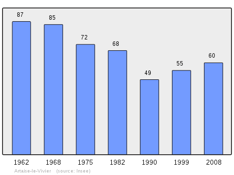
Demography
In 2010 the commune had 59 inhabitants. The evolution of the number of inhabitants is known from the population censuses conducted in the commune since 1793. From the 21st century, a census of communes with fewer than 10,000 inhabitants is held every five years, unlike larger towns that have a sample survey every year.[Note 1]
| 1793 | 1800 | 1806 | 1821 | 1831 | 1836 | 1841 | 1846 | 1851 |
|---|---|---|---|---|---|---|---|---|
| 265 | 318 | 374 | 352 | 360 | 381 | 378 | 391 | 376 |
| 1856 | 1861 | 1866 | 1872 | 1876 | 1881 | 1886 | 1891 | 1896 |
|---|---|---|---|---|---|---|---|---|
| - | - | 413 | 388 | 389 | 345 | 315 | 279 | 252 |
| 1901 | 1906 | 1911 | 1921 | 1926 | 1931 | 1936 | 1946 | 1954 |
|---|---|---|---|---|---|---|---|---|
| 226 | 233 | 186 | 152 | 150 | 121 | 117 | 71 | 95 |
| 1962 | 1968 | 1975 | 1982 | 1990 | 1999 | 2006 | 2010 | - |
|---|---|---|---|---|---|---|---|---|
| 87 | 85 | 72 | 68 | 49 | 55 | - | 59 | - |
Sources : Ldh/EHESS/Cassini until 1962, INSEE database from 1968 (population without double counting and municipal population from 2006)
Sites and monuments
- The Church of Saint-Georges contains a Statue of Saint Georges (18th century)
 which is registered as an historical object.[3]
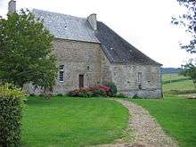
 - The Raminoise fortified house
Picture Gallery
-
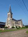
The church
-

Entrance to the church
-
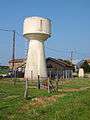
Artaise water tower
-
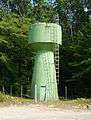
Le Vivier water tower
-

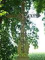
The calvary
-
Wayside Cross
-

Wayside Cross
-
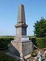
The War Memorial
-
School bus stop
See also
External links
- Artaise-le-Vivier on the National Geographic Institute website (French)
- 3 Cantons official website (French)
- Artaise-le-Vivier on Lion1906
- Artaise-le-Vivier on Google Maps
- Artaise-le-Vivier on Géoportail, National Geographic Institute (IGN) website (French)
- Artaife and le Vivier on the 1750 Cassini Map
- Artaise-le-Vivier on the INSEE website (French)
- INSEE (French)
Notes and references
Notes
- ↑ At the beginning of the 21st century, the methods of identification have been modified by Law No. 2002-276 of 27 February 2002, the so-called "law of local democracy" and in particular Title V "census operations" allows, after a transitional period running from 2004 to 2008, the annual publication of the legal population of the different French administrative districts. For communes with a population greater than 10,000 inhabitants, a sample survey is conducted annually, the entire territory of these communes is taken into account at the end of the period of five years. The first "legal population" after 1999 under this new law came into force on 1 January 2009 and was based on the census of 2006.
References
- 1 2 3 Google Maps
- ↑ List of Mayors of France (French)
- ↑ Ministry of Culture, Palissy PM08000024 Statue: Saint Georges
(French)

| Wikimedia Commons has media related to Artaise-le-Vivier. |