Hierges
| Hierges | ||
|---|---|---|
 | ||
| ||
 Hierges | ||
|
Location within Grand Est region  Hierges | ||
| Coordinates: 50°06′21″N 4°44′26″E / 50.1058°N 4.7406°ECoordinates: 50°06′21″N 4°44′26″E / 50.1058°N 4.7406°E | ||
| Country | France | |
| Region | Grand Est | |
| Department | Ardennes | |
| Arrondissement | Charleville-Mézières | |
| Canton | Givet | |
| Intercommunality | Ardennes Rives de Meuse | |
| Government | ||
| • Mayor (2008–2014) | René Bourgeois | |
| Area1 | 4.05 km2 (1.56 sq mi) | |
| Population (2008)2 | 212 | |
| • Density | 52/km2 (140/sq mi) | |
| Time zone | CET (UTC+1) | |
| • Summer (DST) | CEST (UTC+2) | |
| INSEE/Postal code | 08226 / 08320 | |
|
1 French Land Register data, which excludes lakes, ponds, glaciers > 1 km² (0.386 sq mi or 247 acres) and river estuaries. 2 Population without double counting: residents of multiple communes (e.g., students and military personnel) only counted once. | ||

Hierges is a commune in the Ardennes department in the Grand Est region in northern France.
Hierges is located in the Meuse valley along the Belgian border.
Population
| Historical population | ||
|---|---|---|
| Year | Pop. | ±% |
| 1962 | 245 | — |
| 1968 | 297 | +21.2% |
| 1975 | 324 | +9.1% |
| 1982 | 300 | −7.4% |
| 1990 | 254 | −15.3% |
| 1999 | 220 | −13.4% |
| 2008 | 212 | −3.6% |
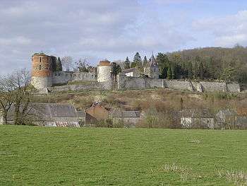
Sights and monuments
- Château de Hierges, a castle whose origins go back to the 16th century, was built on the site of an earlier 9th century castrum.
See also
References
| Wikimedia Commons has media related to Hierges. |
This article is issued from Wikipedia - version of the 10/29/2016. The text is available under the Creative Commons Attribution/Share Alike but additional terms may apply for the media files.