Monthermé
| Monthermé | ||
|---|---|---|
 | ||
| ||
 Monthermé | ||
|
Location within Grand Est region  Monthermé | ||
| Coordinates: 49°53′11″N 4°43′56″E / 49.8864°N 4.7322°ECoordinates: 49°53′11″N 4°43′56″E / 49.8864°N 4.7322°E | ||
| Country | France | |
| Region | Grand Est | |
| Department | Ardennes | |
| Arrondissement | Charleville-Mézières | |
| Canton | Monthermé | |
| Intercommunality | Meuse et Semoy | |
| Government | ||
| • Mayor (2008–2014) | Alain Bernard | |
| Area1 | 32.33 km2 (12.48 sq mi) | |
| Population (2008)2 | 2,498 | |
| • Density | 77/km2 (200/sq mi) | |
| Time zone | CET (UTC+1) | |
| • Summer (DST) | CEST (UTC+2) | |
| INSEE/Postal code | 08302 / 08800 | |
|
1 French Land Register data, which excludes lakes, ponds, glaciers > 1 km² (0.386 sq mi or 247 acres) and river estuaries. 2 Population without double counting: residents of multiple communes (e.g., students and military personnel) only counted once. | ||
.svg.png)
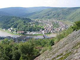
Monthermé is a commune in the Ardennes department in northern France.
Geography
The river Semois (or Semoy) joins the river Meuse in Monthermé.
Population
| Historical population | ||
|---|---|---|
| Year | Pop. | ±% |
| 1793 | 1,520 | — |
| 1800 | 1,396 | −8.2% |
| 1806 | 1,425 | +2.1% |
| 1821 | 1,379 | −3.2% |
| 1831 | 1,660 | +20.4% |
| 1836 | 1,620 | −2.4% |
| 1841 | 1,976 | +22.0% |
| 1846 | 2,126 | +7.6% |
| 1851 | 2,299 | +8.1% |
| 1866 | 2,550 | +10.9% |
| 1872 | 2,599 | +1.9% |
| 1876 | 3,024 | +16.4% |
| 1881 | 3,383 | +11.9% |
| 1886 | 3,699 | +9.3% |
| 1891 | 3,870 | +4.6% |
| 1896 | 4,150 | +7.2% |
| 1901 | 4,272 | +2.9% |
| 1906 | 4,170 | −2.4% |
| 1911 | 4,456 | +6.9% |
| 1921 | 3,621 | −18.7% |
| 1926 | 3,842 | +6.1% |
| 1931 | 3,889 | +1.2% |
| 1936 | 3,705 | −4.7% |
| 1946 | 3,018 | −18.5% |
| 1954 | 3,468 | +14.9% |
| 1962 | 3,589 | +3.5% |
| 1968 | 3,212 | −10.5% |
| 1975 | 3,299 | +2.7% |
| 1982 | 3,103 | −5.9% |
| 1990 | 2,866 | −7.6% |
| 1999 | 2,791 | −2.6% |
| 2008 | 2,498 | −10.5% |
See also
References
| Wikimedia Commons has media related to Monthermé. |
This article is issued from Wikipedia - version of the 2/11/2016. The text is available under the Creative Commons Attribution/Share Alike but additional terms may apply for the media files.