Auge, Ardennes
| Auge | ||
|---|---|---|
|
Entry to the village | ||
| ||
 Auge | ||
|
Location within Grand Est region  Auge | ||
| Coordinates: 49°51′41″N 4°16′15″E / 49.8614°N 4.2708°ECoordinates: 49°51′41″N 4°16′15″E / 49.8614°N 4.2708°E | ||
| Country | France | |
| Region | Grand Est | |
| Department | Ardennes | |
| Arrondissement | Charleville-Mézières | |
| Canton | Signy-le-Petit | |
| Intercommunality | Ardennes Thiérache | |
| Government | ||
| • Mayor (2008–2020) | Jean-Yves Chevanne | |
| Area1 | 4.5 km2 (1.7 sq mi) | |
| Population (2010)2 | 52 | |
| • Density | 12/km2 (30/sq mi) | |
| Time zone | CET (UTC+1) | |
| • Summer (DST) | CEST (UTC+2) | |
| INSEE/Postal code | 08030 / 08380 | |
| Elevation |
199–262 m (653–860 ft) (avg. 250 m or 820 ft) | |
|
1 French Land Register data, which excludes lakes, ponds, glaciers > 1 km² (0.386 sq mi or 247 acres) and river estuaries. 2 Population without double counting: residents of multiple communes (e.g., students and military personnel) only counted once. | ||
_city_limit_sign.JPG)
Auge is a French commune in the Ardennes department in the Grand Est region of north-eastern France.
Geography
Auge is located some 45 km west by north-west of Charleville-Mézières and 22 km east by south-east of Hirson. The western border of the commune is the border between the departments of Ardennes and Aisne. Access to the commune is by the European route E44 (D 8043) from Hirson which passes through the north of the commune and continues east to Maubert-Fontaine. Access to the village is by either the Grande Rue or by the Ruelle de l'Église which both branch south from the E44. Apart from a band of forest on the south-eastern border (The Bois de Moirvaux) and some patches of forest in the south-west the commune is entirely farmland.[1]
Neighbouring communes and villages[1]
 |
Any-Martin-Rieux | Fligny | Tarzy | |
| Leuze | |
Neuville-lez-Beaulieu | ||
| ||||
| | ||||
| Aubenton | Bossus-lès-Rumigny | Antheny |
Toponymy
The name of the town was written Ogiae in 1112 in a privilege of Pope Paschal II to the Abbey of Saint-Nicaise in Reims and as Oggeium in a bull of Innocent II for the same monastery at Reims.[2]
History
This site has been on an ancient road between Mézières and the North since Classical Antiquity. Gallo-Roman foundations, coins, and pieces of pottery have been found.[3]
Heraldry
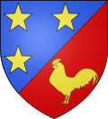 |
Blazon: Party per bend sinister, at 1 Azure, three mullets of Or in orle; at 2 Gules, a cock of Or. |
Administration
_Ferme_La_tour_du_vent.JPG)
_mairie.JPG)
_lavoir_B.JPG)
_%C3%89glise_Saint-Gorgery.JPG)
List of Successive Mayors[4]
| From | To | Name | Party | Position |
|---|---|---|---|---|
| 2001 | 2008 | André Triplot | ||
| 2008 | 2020 | Jean-Yves Chevanne |
(Not all data is known)
Demography
In 2010 the commune had 52 inhabitants. The evolution of the number of inhabitants is known from the population censuses conducted in the commune since 1793. From the 21st century, a census of communes with fewer than 10,000 inhabitants is held every five years, unlike larger towns that have a sample survey every year.[Note 1]
| 1793 | 1800 | 1806 | 1821 | 1831 | 1836 | 1841 | 1846 | 1851 |
|---|---|---|---|---|---|---|---|---|
| 148 | 147 | 78 | 145 | 158 | 160 | 177 | 183 | 232 |
| 1856 | 1861 | 1866 | 1872 | 1876 | 1881 | 1886 | 1891 | 1896 |
|---|---|---|---|---|---|---|---|---|
| - | - | 189 | 175 | 174 | 174 | 177 | 173 | 169 |
| 1901 | 1906 | 1911 | 1921 | 1926 | 1931 | 1936 | 1946 | 1954 |
|---|---|---|---|---|---|---|---|---|
| 148 | 142 | 121 | 126 | 114 | 105 | 114 | 112 | 95 |
| 1962 | 1968 | 1975 | 1982 | 1990 | 1999 | 2006 | 2010 | - |
|---|---|---|---|---|---|---|---|---|
| 95 | 82 | 72 | 66 | 69 | 69 | 69 | 52 | - |
Sources : Ldh/EHESS/Cassini until 1962, INSEE database from 1968 (population without double counting and municipal population from 2006)

Sites and monuments
The Tombstone of Jacques de Corderand, his wife, and his son (18th century)![]() in the Church of Saint-Gorgery is registered as an historical object.[5]
in the Church of Saint-Gorgery is registered as an historical object.[5]
Notable people linked to the commune

- Jean-Michel Devresse, a farmer at Auge, relaunched livestock farming of Ardennes Red Turkeys (Dindon rouge des Ardennes) in 1985, so that this species would not disappear.
See also
External links
- Auge on Google Maps
- Auge on Géoportail, National Geographic Institute (IGN) website (French)
- Auge on the 1750 Cassini Map
- Auge on the INSEE website (French)
- INSEE (French)
Notes and references
Notes
- ↑ At the beginning of the 21st century, the methods of identification have been modified by Law No. 2002-276 of 27 February 2002, the so-called "law of local democracy" and in particular Title V "census operations" allows, after a transitional period running from 2004 to 2008, the annual publication of the legal population of the different French administrative districts. For communes with a population greater than 10,000 inhabitants, a sample survey is conducted annually, the entire territory of these communes is taken into account at the end of the period of five years. The first "legal population" after 1999 under this new law came into force on 1 January 2009 and was based on the census of 2006.
References
- 1 2 Google Maps
- ↑ Auguste Longnon, Study on the pagi of Gaul, Honoré Champion, Paris, 1977, Reprint of the Paris edition of 1869. (French)
- ↑ Blaise Pichon, Archaeological Map of Gaul: 02. Aisne, Volume 2, 2003, p.292 (French)
- ↑ List of Mayors of France (French)
- ↑ Ministry of Culture, Palissy PM08000032 Tombstone of Jacques de Corderand, his wife, and his son
(French)

| Wikimedia Commons has media related to Auge, Ardennes. |