Boult-aux-Bois
| Boult-aux-Bois | ||
|---|---|---|
|
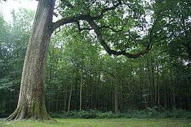
Approximately 500-year-old oak | ||
| ||
 Boult-aux-Bois | ||
|
Location within Grand Est region  Boult-aux-Bois | ||
| Coordinates: 49°25′55″N 4°50′35″E / 49.4319°N 4.8431°ECoordinates: 49°25′55″N 4°50′35″E / 49.4319°N 4.8431°E | ||
| Country | France | |
| Region | Grand Est | |
| Department | Ardennes | |
| Arrondissement | Vouziers | |
| Canton | Chesne | |
| Intercommunality | Argonne Ardennaise | |
| Government | ||
| • Mayor (2008–2014) | Frédéric Mathias | |
| Area1 | 15.2 km2 (5.9 sq mi) | |
| Population (2008)2 | 146 | |
| • Density | 9.6/km2 (25/sq mi) | |
| Time zone | CET (UTC+1) | |
| • Summer (DST) | CEST (UTC+2) | |
| INSEE/Postal code | 08075 / 08240 | |
| Elevation |
166–238 m (545–781 ft) (avg. 180 m or 590 ft) | |
|
1 French Land Register data, which excludes lakes, ponds, glaciers > 1 km² (0.386 sq mi or 247 acres) and river estuaries. 2 Population without double counting: residents of multiple communes (e.g., students and military personnel) only counted once. | ||
.svg.png)
Boult-aux-Bois is a commune in the Ardennes department in northern France.
Population
| Historical population | ||
|---|---|---|
| Year | Pop. | ±% |
| 1793 | 440 | — |
| 1851 | 602 | +36.8% |
| 1866 | 549 | −8.8% |
| 1891 | 385 | −29.9% |
| 1906 | 300 | −22.1% |
| 1921 | 215 | −28.3% |
| 1946 | 184 | −14.4% |
| 1962 | 154 | −16.3% |
| 1968 | 158 | +2.6% |
| 1975 | 127 | −19.6% |
| 1982 | 143 | +12.6% |
| 1990 | 133 | −7.0% |
| 1999 | 148 | +11.3% |
| 2008 | 146 | −1.4% |
See also
References
| Wikimedia Commons has media related to Boult-aux-Bois. |
This article is issued from Wikipedia - version of the 9/17/2015. The text is available under the Creative Commons Attribution/Share Alike but additional terms may apply for the media files.