Barkhamsted, Connecticut
| Barkhamsted, Connecticut | ||
|---|---|---|
| Town | ||
| ||
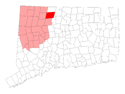 Location in Litchfield County, Connecticut | ||
| Coordinates: 41°55′45″N 72°58′20″W / 41.92917°N 72.97222°WCoordinates: 41°55′45″N 72°58′20″W / 41.92917°N 72.97222°W | ||
| Country | United States | |
| State | Connecticut | |
| NECTA | Hartford | |
| Region | Litchfield Hills | |
| Incorporated | 1779 | |
| Government | ||
| • Type | Selectman-town meeting | |
| • First Selectman | Donald S. Stein (D) | |
| • Selectman | Raymond P. Pech (D) | |
| • Selectman | Mark Hemenway (R) | |
| Area | ||
| • Total | 38.8 sq mi (100.5 km2) | |
| • Land | 36.2 sq mi (93.8 km2) | |
| • Water | 2.6 sq mi (6.8 km2) | |
| Elevation | 561 ft (171 m) | |
| Population (2005)[1] | ||
| • Total | 3,711 | |
| • Density | 103/sq mi (40/km2) | |
| Time zone | Eastern (UTC-5) | |
| • Summer (DST) | Eastern (UTC-4) | |
| ZIP code | 06063, 06065 | |
| Area code(s) | 860 | |
| FIPS code | 09-02760 | |
| GNIS feature ID | 0213386 | |
| Website |
www | |

Barkhamsted is a town in Litchfield County in Connecticut and contains seven villages, West Hill, Mallory, Barkhamsted Center, Center Hill, Washington Hill, Pleasant Valley and Riverton. The population was 3,494 at the 2000 census. Barkhamsted was named after Berkhamsted, Hertfordshire, England.[2]
Geography
According to the United States Census Bureau, the town has a total area of 38.8 square miles (100 km2), of which, 36.2 square miles (94 km2) of it is land and 2.6 square miles (6.7 km2) of it (6.72%) is water. A high percentage of the land in the town is owned by the State of Connecticut as state forest (People's State Forest, American Legion State Forest, Tunxis State Forest, and Enders State Forest) and by the Metropolitan District Commission (MDC) as water supply area. Major bodies of water include the Barkhamsted Reservoir, Lake McDonough, and the Farmington River.
Principal communities
- Barkhamsted Hollow (historical; became the Barkhamsted Reservoir in the early 20th century)
- Center Hill
- Pleasant Valley
- Riverton
Demographics
| Historical population | |||
|---|---|---|---|
| Census | Pop. | %± | |
| 1820 | 1,592 | — | |
| 1850 | 1,524 | — | |
| 1860 | 1,272 | −16.5% | |
| 1870 | 1,439 | 13.1% | |
| 1880 | 1,297 | −9.9% | |
| 1890 | 1,130 | −12.9% | |
| 1900 | 864 | −23.5% | |
| 1910 | 865 | 0.1% | |
| 1920 | 719 | −16.9% | |
| 1930 | 697 | −3.1% | |
| 1940 | 724 | 3.9% | |
| 1950 | 946 | 30.7% | |
| 1960 | 1,370 | 44.8% | |
| 1970 | 2,066 | 50.8% | |
| 1980 | 2,935 | 42.1% | |
| 1990 | 3,369 | 14.8% | |
| 2000 | 3,494 | 3.7% | |
| 2010 | 3,799 | 8.7% | |
| Est. 2014 | 3,705 | [3] | −2.5% |
As of 2010 Barhamsted had a population of 3,799. The racial composition of the population was 97.5% white, 0.3% black or African American, 0.6% Asian, 0.6% from some other race and 1.1% reporting two or more races. 1.5% of the population was Hispanic or Latino of any race.[5]
As of the census[6] of 2000, there were 3,494 people, 1,334 households, and 1,036 families residing in the town. The population density was 96.5 people per square mile (37.2/km²). There were 1,436 housing units at an average density of 39.6 per square mile (15.3/km²). The racial makeup of the town was 98.54% White, 0.06% African American, 0.17% Native American, 0.40% Asian, 0.29% from other races, and 0.54% from two or more races. Hispanic or Latino of any race were 0.89% of the population.
There were 1,334 households out of which 36.2% had children under the age of 18 living with them, 68.2% were married couples living together, 6.2% had a female householder with no husband present, and 22.3% were non-families. 16.9% of all households were made up of individuals and 4.9% had someone living alone who was 65 years of age or older. The average household size was 2.62 and the average family size was 2.95.
In the town the population was spread out with 25.0% under the age of 18, 4.8% from 18 to 24, 31.3% from 25 to 44, 28.8% from 45 to 64, and 10.1% who were 65 years of age or older. The median age was 40 years. For every 100 females there were 101.3 males. For every 100 females age 18 and over, there were 100.8 males.
The median income for a household in the town was $65,972, and the median income for a family was $73,218. Males had a median income of $51,925 versus $38,102 for females. The per capita income for the town was $28,961. About 1.8% of families and 3.0% of the population were below the poverty line, including 3.8% of those under age 18 and 1.4% of those age 65 or over.
| Voter registration and party enrollment as of October 25, 2005[7] | |||||
|---|---|---|---|---|---|
| Party | Active voters | Inactive voters | Total voters | Percentage | |
| Republican | 707 | 21 | 728 | 28.26% | |
| Democratic | 598 | 13 | 611 | 23.72% | |
| Unaffiliated | 1,175 | 46 | 1,221 | 47.40% | |
| Minor Parties | 15 | 1 | 16 | 0.62% | |
| Total | 2,495 | 81 | 2,576 | 100% | |
Services
The town of Barkhamsted has one elementary school located in the village of Pleasant Valley.
Its high school and middle school students attend Northwestern Regional School District#7. The actual facility, however, is located in the neighboring city of Winsted. Barkhamsted schoolchildren attend the Regional High/Middle School with students from three neighboring towns.
Barkhamsted has three fire departments: the Pleasant Valley Volunteer Fire Department, Riverton Volunteer Fire Company, and Barkhamsted East Volunteer Fire Company. The town employs one paid daytime driver/firefighter to assist the volunteers during normal work hours.
Emergency medical care is provided by the Winsted Area Ambulance Association, the New Hartford Volunteer Ambulance Association, and a Campion paramedic. Both Winsted and New Hartford are volunteer-based services.
Transportation
There is no public transportation in Barkhamsted. The principal means of transportation is the automobile. The primary state highways in town are Route 44, Route 20, Route 219, Route 318, and Route 181. The village of Riverton is located along Route 20 and the village of Pleasant Valley is off Route 44 (via Route 318). Bradley International Airport is approximately 30 miles east.
Notable locations
Barkhamsted is home of the historical Saville Dam, and People's State Forest, where Stone Museum is located.
Within the Barkhamsted Reservoir lie the foundations of Barkhamsted Hollow, the historic center of town that was purchased by the Metropolitan District Commission in the early 20th century to create a reservoir to serve the Hartford area. This area was flooded following the construction of the Saville Dam on the East Branch of the Farmington River, and took 8 years to fill.
Just south of the Barkhamsted Reservoir is Lake McDonough, also known as the compensating reservoir and owned by the MDC. Originally created to ensure the riparian rights of downstream mill owners, this lake now serves the recreational interests of the surrounding area with beaches, boating, and fishing.
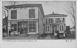
The center of Pleasant Valley contains the Pleasant Valley General Store, the Barkhamsted Elementary School, the Pleasant Valley Drive-In, the post office (zip code 06063), and the town hall.
The center of Riverton holds a post office (zip code 06065), the Riverton General store, the Riverton Inn, the Riverton Congregational Church, the grange, and the fair grounds. This is also the location of the annual Riverton Fair, which takes place the second weekend of October each year, and is Connecticut's last fair of the year.
The West Branch of the Farmington River is designated as a "Wild and Scenic River." It runs through the villages of Riverton and Pleasant Valley and hosts fishermen year-round in the catch-and-release section. On the opening day of fishing season each year, a fishing tournament is held in Riverton, drawing anglers from throughout Connecticut, New York, and Massachusetts.
On the National Register of Historic Places

- American Legion Forest CCC Shelter — west side of West River Road, American Legion State Forest (added in 1986)
- Barkhamsted Center Historic District — 119, 131 Center Hill Road; 2,5,6,8 Old Town Hall Road (added in 1999)
- Beaver Meadow Complex Prehistoric Archeological District (added in 1988)
- Lighthouse Archeological Site (5-37) (added in 1991)
- William Moore, Jr., House — 5 Mountain Road (added May 14, 1999)
- Old Riverton Inn — 436 E. River Rd. (added in 1992)
- Peoples Forest Museum — Greenwood Road, People's State Forest (added in 1986)
- Riverton Historic District (Barkhamsted, Connecticut) — (added in 2007)
- Union Church/St. Paul's Church — Riverton Road (added in 1985)
References

- ↑ U.S. Census Bureau Population Estimates
- ↑ https://web.archive.org/web/20080314164126/http://www.sots.ct.gov/RegisterManual/SectionVII/townorder.htm
- ↑ "Annual Estimates of the Resident Population for Incorporated Places: April 1, 2010 to July 1, 2014". Retrieved June 4, 2015.
- ↑ "Census of Population and Housing". Census.gov. Archived from the original on May 11, 2015. Retrieved June 4, 2015.
- ↑ 2010 population by race and Hispanic or Latino by place chart for Connecticut from the US Census
- ↑ "American FactFinder". United States Census Bureau. Archived from the original on September 11, 2013. Retrieved 2008-01-31.
- ↑ "Registration and Party Enrollment Statistics as of October 25, 2005" (PDF). Connecticut Secretary of State. Archived from the original (PDF) on 2006-09-23. Retrieved 2006-10-02.
External links
- Town government Web site
- Barkhamsted Historical Society Web site
- Northwest Connecticut Arts Council
- Northwest Connecticut Convention and Visitors Bureau
- Northwestern Connecticut Community College in Winsted
- Farmington River Coordinating Committee (FRCC)

Municipalities and communities of Litchfield County, Connecticut, United States | ||
|---|---|---|
| Consolidated city | 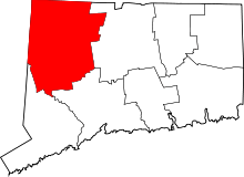 | |
| Towns | ||
| Non-consolidated city |
| |
| Boroughs | ||
| Other communities | ||