Baron-sur-Odon
| Baron-sur-Odon | ||
|---|---|---|
 | ||
| ||
 Baron-sur-Odon | ||
|
Location within Normandy region  Baron-sur-Odon | ||
| Coordinates: 49°07′43″N 0°28′57″W / 49.1286°N 0.4825°WCoordinates: 49°07′43″N 0°28′57″W / 49.1286°N 0.4825°W | ||
| Country | France | |
| Region | Normandy | |
| Department | Calvados | |
| Arrondissement | Caen | |
| Canton | Évrecy | |
| Intercommunality | Évrecy-Orne-Odon | |
| Government | ||
| • Mayor (2008–2020) | Georges Laignel | |
| Area1 | 6.43 km2 (2.48 sq mi) | |
| Population (2010)2 | 842 | |
| • Density | 130/km2 (340/sq mi) | |
| Time zone | CET (UTC+1) | |
| • Summer (DST) | CEST (UTC+2) | |
| INSEE/Postal code | 14042 / 14210 | |
| Elevation |
25–112 m (82–367 ft) (avg. 84 m or 276 ft) | |
|
1 French Land Register data, which excludes lakes, ponds, glaciers > 1 km² (0.386 sq mi or 247 acres) and river estuaries. 2 Population without double counting: residents of multiple communes (e.g., students and military personnel) only counted once. | ||
Baron-sur-Odon is a French commune in the Calvados department in the Normandy region of north-western France.[1]
The inhabitants of the commune are known as Baronnais or Baronnaises.[2]
The commune has been awarded one flower by the National Council of Towns and Villages in Bloom in the Competition of cities and villages in Bloom.[3]
Geography
Baron-sur-Odon is located some 4 km south-west of Caen and 10 km north-east of Villers-Bocage. It is part of the urban area of Caen. Access to the commune is by the D89 from Tourville-sur-Odon in the north which passes through the village and continues south to Esquay-Notre-Dame. The D214 comes from Gavrus in the south-west and also passes through the village as well as Les Crettes and La Bruyère before continuing north-east to Fontaine-Étoupefour. Apart from the village there are the hamlets of Tourmauville, Les Crettes, and La Bruyère. The commune is mostly farmland except for some forest in the north.[4][5]
The Odon river forms the northern border of the commune as it flows north-east to join the Orne in Caen.
Mapping
A list of online mapping systems can be displayed by clicking on the coordinates (latitude and longitude) in the top right hand corner of this article.
Neighbouring communes and villages
 |
Tourville-sur-Odon | Mouen | Fontaine-Étoupefour | |
| Gavrus | |
Maltot | ||
| ||||
| | ||||
| Évrecy | Esquay-Notre-Dame | Vieux |
Toponymy
The name of the area is attested as Baron in 1138[6] and Baro in the 14th century.[7] The origin of this place name is uncertain. Albert Dauzat suggests the cognomen Baro or a title of German origin Baron.[7] René Lepelley meanwhile detects the Gallic barro meaning "fence" (in old French barre) or the Germanic anthroponym Baro.[8]
History

Baron-sur-Odon appears as Baron on the 1750 Cassini Map[9] and the same on the 1790 version.[10]
The "Chemin Haussé", which passes through the commune, is a Roman road identified as one of the roads included in the Tabula Peutingeriana. The road is mostly straight with embankments hence the name (Haussé means "raised"). This route was used as a line of communication until the end of the Middle Ages. It is also called the "Path of Duke William" on some land registers.[11]
In June 1944, during Operation Epsom, the heights of Hill 112 south-east of Baron-sur-Odon (also in the communes of Fontaine-Étoupefour, Vieux, and Esquay-Notre-Dame) was one objectives for the liberation of Caen. The fighting lasted more than a month.
Heraldry
 |
Blazon: Party per bend sinister, at 1 Gules, two lions passant guardant Or one over the other to sinister and a croix de guerre in chief border; at 2, Azure semy of wavelets Argent debruised by a horseshoe inverted Or; over all a bend sinister charged with the inscription BARON in capital letters of Sable . |
The explanation of this blazon follows:[12]
- The Croix de Guerre was awarded to the commune after the Battle of Hill 112 which took place on its soil.
- The arms of the Basse-Normandie reguion are represented by two golden leopards.
The horseshoe symbolizes the escape of William the Conqueror (from Valognes to Falaise in 1047) with his horse shod in reverse to mislead his pursuers. The ripples represent the river Odon.
Administration
| From | To | Name | Party | Position |
|---|---|---|---|---|
| 1971 | 1983 | Charles Duboscq | ||
| 1983 | 1995 | Gérard Maheut | ||
| 1995 | 2008 | Joseph Desquesnes | ||
| 2008 | 2020[14] | Georges Laignel |
(Not all data is known)
The municipal council consists of 15 members including a Mayor and four deputies.[15]
Twinning
Baron-sur-Odon has twinning associations with:[16]
 Gaukönigshofen (Germany) since 1998.
 Chittlehampton (United Kingdom) since 1986.
Demography
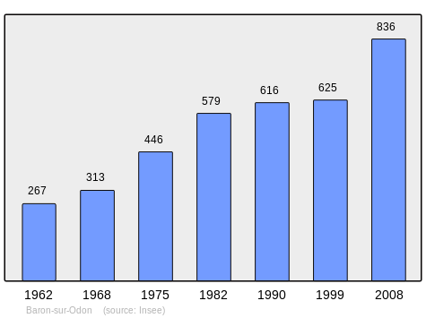
In 2010 the commune had 842 inhabitants. The evolution of the number of inhabitants is known from the population censuses conducted in the commune since 1793. From the 21st century, a census of communes with fewer than 10,000 inhabitants is held every five years, unlike larger communes that have a sample survey every year.[Note 1]
| 1793 | 1800 | 1806 | 1821 | 1831 | 1836 | 1841 | 1846 | 1851 |
|---|---|---|---|---|---|---|---|---|
| 450 | 392 | 461 | 456 | 468 | 497 | 434 | 467 | 430 |
| 1856 | 1861 | 1866 | 1872 | 1876 | 1881 | 1886 | 1891 | 1896 |
|---|---|---|---|---|---|---|---|---|
| 401 | 411 | 418 | 379 | 396 | 359 | 335 | 319 | 318 |
| 1901 | 1906 | 1911 | 1921 | 1926 | 1931 | 1936 | 1946 | 1954 |
|---|---|---|---|---|---|---|---|---|
| 318 | 291 | 261 | 193 | 193 | 208 | 216 | 195 | 228 |
| 1962 | 1968 | 1975 | 1982 | 1990 | 1999 | 2006 | 2010 | - |
|---|---|---|---|---|---|---|---|---|
| 267 | 313 | 446 | 579 | 616 | 625 | 842 | - |
Sources : Ldh/EHESS/Cassini until 1962, INSEE database from 1968 (population without double counting and municipal population from 2006)
Culture and heritage


Civil heritage
- The Chateau of Tourmeauville (18th century) with its Chapel (19th century)
- A Chateau and Manor (16th century)
 is registered as an historical monument[17]
Religious heritage
The Church of Notre-Dame of the Nativity (12th century)![]() is registered as an historical monument.[18]
is registered as an historical monument.[18]
See also
Notes and references
Notes
- ↑ At the beginning of the 21st century, the methods of identification have been modified by Law No. 2002-276 of 27 February 2002, the so-called "law of local democracy" and in particular Title V "census operations" allows, after a transitional period running from 2004 to 2008, the annual publication of the legal population of the different French administrative districts. For communes with a population greater than 10,000 inhabitants, a sample survey is conducted annually and the entire territory of these communes is taken into account at the end of the period of five years. The first "legal population" after 1999 under this new law came into force on 1 January 2009 and was based on the census of 2006.
References
- ↑ Baron-sur-Odon on Lion1906
- ↑ Inhabitants of Calvados (French)
- ↑ Competition for Towns and Villages in Bloom website Archived December 10, 2014, at the Wayback Machine. (French)
- 1 2 Baron-sur-Odon on Google Maps
- ↑ Baron-sur-Odon on the Géoportail from National Geographic Institute (IGN) website (French)
- ↑ Ernest Nègre, General Toponymy of France, Librairie Droz, 1990, Vol II, 676 pages, p. 829, ISBN 9782600001335 (French).
- 1 2 Albert Dauzat and Charles Rostaing, Etymological Dictionary of place names in France, Larousse, Paris, 1963 (French)
- ↑ René Lepelley, Etymological Dictionary of names of communes in Normandy, Éditions Charles Corlet, Condé-sur-Noireau, 1996, BnF 36174448w p. 59 (French)
- ↑ Baron on the 1750 Cassini Map
- ↑ Baron on the 1790 Cassini Map
- ↑ The Chemin Haussé on Panoramio (French)
- ↑ From an explanatory document from the town hall of Baron-sur-Odon: the blazon project was proposed in the municipal council by Mr. Collard and Mr. Maheut and adopted unanimously.
- ↑ List of Mayors of France (French)
- ↑ Reelection 2014: Georges Laignel was elected Mayor for a second term, Ouest-France, consulted on 8 April 2014 (French)
- ↑ art L. 2121-2 of the General Code of Collective Territories (French).
- ↑ National Commission for Decentralised cooperation (French)
- ↑ Ministry of Culture, Mérimée PA00111036 (French)
- ↑ Ministry of Culture, Mérimée PA00111037 Church of Notre-Dame of the Nativity (French)
External links
- Commune of Baron-sur-Odon website (French)
| Wikimedia Commons has media related to Baron-sur-Odon. |