Courseulles-sur-Mer
| Courseulles-sur-Mer | ||
|---|---|---|
 | ||
| ||
 Courseulles-sur-Mer | ||
|
Location within Normandy region  Courseulles-sur-Mer | ||
| Coordinates: 49°20′01″N 0°27′23″W / 49.3336°N 0.4564°WCoordinates: 49°20′01″N 0°27′23″W / 49.3336°N 0.4564°W | ||
| Country | France | |
| Region | Normandy | |
| Department | Calvados | |
| Arrondissement | Caen | |
| Canton | Creully | |
| Intercommunality | Bessin, Seulles et Mer | |
| Government | ||
| • Mayor (2008–2014) | Frédéric Pouille | |
| Area1 | 7.92 km2 (3.06 sq mi) | |
| Population (2008)2 | 4,169 | |
| • Density | 530/km2 (1,400/sq mi) | |
| Time zone | CET (UTC+1) | |
| • Summer (DST) | CEST (UTC+2) | |
| INSEE/Postal code | 14191 / 14470 | |
| Elevation |
1–51 m (3.3–167.3 ft) (avg. 8 m or 26 ft) | |
|
1 French Land Register data, which excludes lakes, ponds, glaciers > 1 km² (0.386 sq mi or 247 acres) and river estuaries. 2 Population without double counting: residents of multiple communes (e.g., students and military personnel) only counted once. | ||
.svg.png)
Courseulles-sur-Mer is a commune in the Calvados department in the Normandy region in northwestern France.
It is a popular tourist destination not only with locals but also with international visitors who come to tour the Normandy landing beaches. The population of the town can reach 15,000 people in the summer months owing to a large number of summer homes owned for the most part by Parisians.
The town is split in two by the river Seulles. Today the port of Courseulles bustles with fishing boats and pleasure craft, coming from as far away as the Netherlands, yet in the summer of 1944, the Canadian military used it to unload upwards of 1,000 tons of material a day for the first two weeks following D-Day on 6 June 1944.
History
 German forces surrendering to Canadian troops in Courseulles.
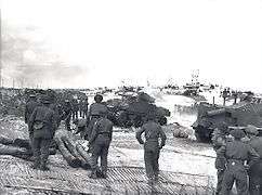 Canadian soldiers land on the crowded beach at Courseulles, June 1944.
More than 14,000 Canadians stormed the 8-kilometre (5.0 mi) stretch of beach between Graye-sur-Mer and St. Aubin-sur-Mer on 6 June 1944. They were followed by 150,000 additional Canadian troops over the next few months. Canadian soldiers of the 3rd Canadian Infantry Division and 2nd Canadian Armoured Brigade, which formed the Canadian assault force on Juno Beach suffered 1074 casualties, including 369 killed on the beach and in the countryside on the first day of the invasion. The Canadians reached almost 10 km (6.2 mi) inland on the first day of fighting, the farthest advance of any of the Allied landing forces. The Canadian military cemetery of Bény-Reviers is the resting place of 2,043 Canadians and 1 Frenchman. The land for this cemetery was donated by France to the Government of Canada after the Second World War and lies 4 km (2.5 mi) inland from Courseulles-sur-Mer just off Route 79.
The Juno Beach Centre is a museum located at Courseulles-sur-Mer, at the head of the Juno invasion beach on which 14,000 Canadian troops landed on D-Day 6 June 1944. The museum opened on 6 June 2003, the 59th anniversary of the D-Day landings.
Until 1957, the town's name was simply Courseulles.[1]
Population
| Historical population | ||
|---|---|---|
| Year | Pop. | ±% |
| 1962 | 1,684 | — |
| 1968 | 1,938 | +15.1% |
| 1975 | 2,538 | +31.0% |
| 1982 | 2,992 | +17.9% |
| 1990 | 3,182 | +6.4% |
| 1999 | 3,886 | +22.1% |
| 2008 | 4,169 | +7.3% |
International relations
The commune is twinned with:
- Dartmouth, Devon, UK since 1977
- Rigaud, Québec, Canada since 1991
- Goldbach, Bavaria, Lower Franconia (Unterfranken) in Bavaria, Germany since 1995
See also
References
- ↑ "Commune de Courseulles-sur-Mer (14191)" [Commune of Courseulles-sur-Mer (14191)] (in French). Institut national de la statistique et des études économiques. Retrieved 1 December 2015.
| Wikimedia Commons has media related to Courseulles-sur-Mer. |