Bauquay
| Bauquay | |
|---|---|
|
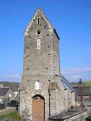
The Church of Sasint-Mathieu | |
 Bauquay | |
|
Location within Normandy region  Bauquay | |
| Coordinates: 49°02′04″N 0°36′53″W / 49.0344°N 0.6147°WCoordinates: 49°02′04″N 0°36′53″W / 49.0344°N 0.6147°W | |
| Country | France |
| Region | Normandy |
| Department | Calvados |
| Arrondissement | Vire |
| Canton | Aunay-sur-Odon |
| Intercommunality | Aunay-Caumont-Intercom |
| Government | |
| • Mayor (2008–2014) | Gilles Leconte |
| Area1 | 1.79 km2 (0.69 sq mi) |
| Population (2010)2 | 254 |
| • Density | 140/km2 (370/sq mi) |
| Time zone | CET (UTC+1) |
| • Summer (DST) | CEST (UTC+2) |
| INSEE/Postal code | 14056 / 14260 |
| Elevation |
100–163 m (328–535 ft) (avg. 130 m or 430 ft) |
|
1 French Land Register data, which excludes lakes, ponds, glaciers > 1 km² (0.386 sq mi or 247 acres) and river estuaries. 2 Population without double counting: residents of multiple communes (e.g., students and military personnel) only counted once. | |
Bauquay is a French commune in the Calvados department in the Normandy region of north-western France.[1]
The inhabitants of the commune are known as Buxois or Buxoises.[2]
Geography
Bauquay is located some 6 km south by south-east of Villers-Bocage just north-west of Aunay-sur-Odon. Access to the commune is by the D8 road from Aunay-sur-Odon which passes through the length of the commune and the village and continues north-east to Évrecy. Apart from the village there are the hamlets of Le Vloquier and Les Perquettes. The commune is entirely farmland.[3][4]
The Odon river forms the south-western border of the commune as it flows north to eventually join the Orne at Caen. The Douvette river forms the eastern border of the commune as it flows north then north-west to join the Odon near Longvillers.[3][4]
Geologically the commune is part of the Armorican Massif.
The climate is oceanic as in all of western France. The nearest weather station is Caen, 21 km 3.
Mapping
A list of online mapping systems can be displayed by clicking on the coordinates (latitude and longitude) in the top right hand corner of this article.
Neighbouring communes and villages
 |
Longvillers | Le Mesnil-au-Grain | | |
| Saint-Georges-d'Aunay | |
Courvaudon | ||
| ||||
| | ||||
| Aunay-sur-Odon | Bonnemaison |
Toponymy
The name of the locality was attested as Balcheium in 1082[5] The toponym comes from the Gallic balc, meaning "clay", which gave the old French bauche with the same meaning. The place used to supply clay for construction.[6]
Bauquay appears as Beaugnay on the 1750 Cassini Map[7] and the same on the 1790 version.[8]
Administration
| From | To | Name | Party | Position |
|---|---|---|---|---|
| 1995 | 2020[10] | Gilles Leconte |
(Not all data is known)
The Municipal Council is composed of 11 members including the Mayor and 2 deputies.[11]
Demography
In 2010 the commune had 254 inhabitants. The evolution of the number of inhabitants is known from the population censuses conducted in the commune since 1793. From the 21st century, a census of communes with fewer than 10,000 inhabitants is held every five years, unlike larger communes that have a sample survey every year.[Note 1]
| 1793 | 1800 | 1806 | 1821 | 1831 | 1836 | 1841 | 1846 | 1851 |
|---|---|---|---|---|---|---|---|---|
| 100 | 335 | 422 | 334 | 334 | 332 | 307 | 289 | 294 |
| 1856 | 1861 | 1866 | 1872 | 1876 | 1881 | 1886 | 1891 | 1896 |
|---|---|---|---|---|---|---|---|---|
| 276 | 270 | 227 | 207 | 187 | 190 | 190 | 187 | 170 |
| 1901 | 1906 | 1911 | 1921 | 1926 | 1931 | 1936 | 1946 | 1954 |
|---|---|---|---|---|---|---|---|---|
| 147 | 158 | 138 | 129 | 132 | 123 | 119 | 118 | 155 |
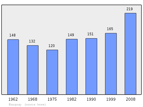
| 1962 | 1968 | 1975 | 1982 | 1990 | 1999 | 2006 | 2010 | - |
|---|---|---|---|---|---|---|---|---|
| 148 | 132 | 120 | 149 | 151 | 165 | 254 | - |
Sources : Ldh/EHESS/Cassini until 1962, INSEE database from 1968 (population without double counting and municipal population from 2006)
Sites and monuments
- The Church of Saint-Mathieu (12th ecntury) with an 18th-century bell tower.
- An Oratory chapel (19th century)
Notable people linked to the commune
- Renaud Allirand, painter and engraver, lived in the commune from 1974 to 1987.
See also
Notes and references
Notes
- ↑ At the beginning of the 21st century, the methods of identification have been modified by Law No. 2002-276 of 27 February 2002, the so-called "law of local democracy" and in particular Title V "census operations" allows, after a transitional period running from 2004 to 2008, the annual publication of the legal population of the different French administrative districts. For communes with a population greater than 10,000 inhabitants, a sample survey is conducted annually and the entire territory of these communes is taken into account at the end of the period of five years. The first "legal population" after 1999 under this new law came into force on 1 January 2009 and was based on the census of 2006.
References
- ↑ Bauquay on Lion1906
- ↑ Inhabitants of Calvados (French)
- 1 2 3 Bauquay on Google Maps
- 1 2 Bauquay on the Géoportail from National Geographic Institute (IGN) website (French)
- ↑ Albert Dauzat and Charles Rostaing, Etymological Dictionary of place names in France, Larousse, Paris, 1963 (French)
- ↑ René Lepelley, Etymological Dictionary of names of communes in Normandy, Éditions Charles Corlet, Condé-sur-Noireau, 1996, BnF 36174448w p. 59 (French)
- ↑ Beaugnay on the 1750 Cassini Map
- ↑ Beaugnay on the 1790 Cassini Map
- ↑ List of Mayors of France (French)
- ↑ Reelection 2014: Bauquay (14260) - Municipal Elections 2014, Ouest-France, consulted on 1st May 2014 (French)
- ↑ art L. 2121-2 of the General Code of Collective Territories (French).
| Wikimedia Commons has media related to Bauquay. |