Basseneville
| Basseneville | |
|---|---|
|
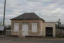
Town hall | |
 Basseneville | |
|
Location within Normandy region  Basseneville | |
| Coordinates: 49°12′01″N 0°07′42″W / 49.2003°N 0.1283°WCoordinates: 49°12′01″N 0°07′42″W / 49.2003°N 0.1283°W | |
| Country | France |
| Region | Normandy |
| Department | Calvados |
| Arrondissement | Lisieux |
| Canton | Cabourg |
| Intercommunality | Pays d'Auge dozuléen |
| Government | |
| • Mayor (2014–2020) | Patrice Germain |
| Area1 | 10.59 km2 (4.09 sq mi) |
| Population (2010)2 | 260 |
| • Density | 25/km2 (64/sq mi) |
| Time zone | CET (UTC+1) |
| • Summer (DST) | CEST (UTC+2) |
| INSEE/Postal code | 14045 / 14670 |
| Elevation |
2–45 m (6.6–147.6 ft) (avg. 6 m or 20 ft) |
|
1 French Land Register data, which excludes lakes, ponds, glaciers > 1 km² (0.386 sq mi or 247 acres) and river estuaries. 2 Population without double counting: residents of multiple communes (e.g., students and military personnel) only counted once. | |
Basseneville is a French commune in the Calvados department in the Normandy region of north-western France.[1]
The inhabitants of the commune are known as Bassenevillais or Bassenevillaises.[2]
Geography
Basseneville is located in the Pays d'Auge some 12 km east of Caen and 8 km south-east of Cabourg. Access to the commune is by the D675 road from Goustranville in the east which passes through the south of the commune continuing south-west to Saint-Samson. The D224A also comes from Saint-Samson and passes through the commune continuing north-east to join the D224 just north-east of the commune. The A13 autoroute passes through the commune from east to west but has no exit - the nearest exit is Exit ![]() 29 Dozulé to the east of the commune which has no direct access the commune and Exit
29 Dozulé to the east of the commune which has no direct access the commune and Exit ![]() 30/31 to the south-west which connects to the D675. Apart from the village there are the hamlets of L'Église, Les Marettes, Saint-Richer, and La Chollerie. The commune is entirely farmland.[3][4]
30/31 to the south-west which connects to the D675. Apart from the village there are the hamlets of L'Église, Les Marettes, Saint-Richer, and La Chollerie. The commune is entirely farmland.[3][4]
The Dives river forms the north-western border of the commune as it flows north-east to join the sea at Cabourg. The Grand Canal forms the south-eastern border of the commune.[3][4]
Mapping
A list of online mapping systems can be displayed by clicking on the coordinates (latitude and longitude) in the top right hand corner of this article.
Neighbouring communes and villages
 |
Bavent | Varaville | Brucourt | |
| Escoville | |
Goustranville | ||
| ||||
| | ||||
| Saint-Samson | Saint-Pierre-du-Jonquet | Beuvron-en-Auge |
History
Basseneville appears as Bafneville on the 1750 Cassini Map[5] and as Bosneville on the 1790 version.[6]
A railway station on the Caen to Dozulé-Putot line existed in the commune from 1881 to 1938. The line that passed through the commune was finally closed in 1943.
Administration
| From | To | Name | Party | Position |
|---|---|---|---|---|
| 1983 | 2008 | André Vardon | ||
| 2008 | 2014 | Jean-François Wantz | Retired | |
| 2014 | 2020[8] | Patrice Germain | Retired |
(Not all data is known)
Demography
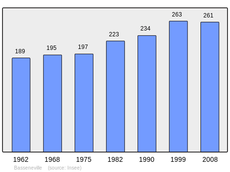
In 2010 the commune had 260 inhabitants. The evolution of the number of inhabitants is known from the population censuses conducted in the commune since 1793. From the 21st century, a census of communes with fewer than 10,000 inhabitants is held every five years, unlike larger communes that have a sample survey every year.[Note 1]
| 1793 | 1800 | 1806 | 1821 | 1831 | 1836 | 1841 | 1846 | 1851 |
|---|---|---|---|---|---|---|---|---|
| 334 | 266 | 302 | 327 | 425 | 446 | 415 | 409 | 367 |
| 1856 | 1861 | 1866 | 1872 | 1876 | 1881 | 1886 | 1891 | 1896 |
|---|---|---|---|---|---|---|---|---|
| 341 | 332 | 360 | 323 | 307 | 302 | 286 | 257 | 240 |
| 1901 | 1906 | 1911 | 1921 | 1926 | 1931 | 1936 | 1946 | 1954 |
|---|---|---|---|---|---|---|---|---|
| 252 | 221 | 216 | 204 | 205 | 188 | 220 | 188 | 197 |
| 1962 | 1968 | 1975 | 1982 | 1990 | 1999 | 2006 | 2010 | - |
|---|---|---|---|---|---|---|---|---|
| 189 | 195 | 197 | 223 | 234 | 263 | 260 | 260 | - |
Sources : Ldh/EHESS/Cassini until 1962, INSEE database from 1968 (population without double counting and municipal population from 2006)
Culture and heritage
Religious heritage
The Chapel of Saint Richer contains several items that are registered as historical objects:
- A Chalice with Paten (18th century)
 [9]
[9] - A Trunk (17th century)[10]
- A Painting with frame: Crucifixion (17th century)[11]
The Parish Church of Notre-Dame also contains several items that are registered as historical objects:
- A Tabernacle (17th century)[12]
- A Painting: The Holy Family (18th century)[13]
- A Painting with frame: Holy Family (18th century)[14]
- An Altar, Retable, and 2 doors (1719)[15]
- A Lectern (1721)[16]
Notable people linked to the commune
- Jean-Victor Durand-Duquesnay (1785 at Basseneville - 1862), Normandy botanist
- Pierre (François-Amand) Bazin (1796 at Basseneville - 1865)
See also
Notes and references
Notes
- ↑ At the beginning of the 21st century, the methods of identification have been modified by Law No. 2002-276 of 27 February 2002, the so-called "law of local democracy" and in particular Title V "census operations" allows, after a transitional period running from 2004 to 2008, the annual publication of the legal population of the different French administrative districts. For communes with a population greater than 10,000 inhabitants, a sample survey is conducted annually and the entire territory of these communes is taken into account at the end of the period of five years. The first "legal population" after 1999 under this new law came into force on 1 January 2009 and was based on the census of 2006.
References
- ↑ Basseneville on Lion1906
- ↑ Inhabitants of Calvados (French)
- 1 2 3 Basseneville on Google Maps
- 1 2 Basseneville on the Géoportail from National Geographic Institute (IGN) website (French)
- ↑ Bafneville on the 1750 Cassini Map
- ↑ Bosneville on the 1790 Cassini Map
- ↑ List of Mayors of France (French)
- ↑ Patrice Germain, new mayor, succeeds Jean-François Wantz, Ouest-France, consulted on 1 February 2015 (French)
- ↑ Ministry of Culture, Palissy PM14000044 Chalice with Paten
 (French)
 - ↑ Ministry of Culture, Palissy PM14000043 Trunk
(French)
- ↑ Ministry of Culture, Palissy PM14000042 Painting: Crucifixion
(French)
- ↑ Ministry of Culture, Palissy PM14001090 Tabernacle (French)
- ↑ Ministry of Culture, Palissy PM14000041 Painting: The Holy Family
(French)
- ↑ Ministry of Culture, Palissy PM14000040 Painting: Holy Family
(French)
- ↑ Ministry of Culture, Palissy PM14000039 Altar, Retable, and 2 doors
(French)
- ↑ Ministry of Culture, Palissy PM14000038 Lectern
(French)
| Wikimedia Commons has media related to Basseneville. |