Courcy, Calvados
For other uses, see Courcy (disambiguation).
| Courcy | |
|---|---|
 | |
 Courcy | |
|
Location within Normandy region  Courcy | |
| Coordinates: 48°58′20″N 0°02′31″W / 48.9722°N 0.0419°WCoordinates: 48°58′20″N 0°02′31″W / 48.9722°N 0.0419°W | |
| Country | France |
| Region | Normandy |
| Department | Calvados |
| Arrondissement | Caen |
| Canton | Morteaux-Coulibœuf |
| Intercommunality | Trois Rivières |
| Government | |
| • Mayor (2008–2014) | Thérèse Thoretton |
| Area1 | 9.12 km2 (3.52 sq mi) |
| Population (2008)2 | 153 |
| • Density | 17/km2 (43/sq mi) |
| Time zone | CET (UTC+1) |
| • Summer (DST) | CEST (UTC+2) |
| INSEE/Postal code | 14190 / 14170 |
| Elevation |
38–79 m (125–259 ft) (avg. 55 m or 180 ft) |
|
1 French Land Register data, which excludes lakes, ponds, glaciers > 1 km² (0.386 sq mi or 247 acres) and river estuaries. 2 Population without double counting: residents of multiple communes (e.g., students and military personnel) only counted once. | |
Courcy is a commune in the Calvados department in the Normandy region in northwestern France.
Population
| Historical population | ||
|---|---|---|
| Year | Pop. | ±% |
| 1962 | 216 | — |
| 1968 | 191 | −11.6% |
| 1975 | 166 | −13.1% |
| 1982 | 154 | −7.2% |
| 1990 | 152 | −1.3% |
| 1999 | 141 | −7.2% |
| 2008 | 153 | +8.5% |
Sights
- Château de Courcy, 12th/13th-century castle.
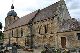
- Church of Saint Gervais and Saint Protais. The church was built, added to and altered between the 12th and 18th centuries. It is constructed of limestone with a tiled roof.
The choir dates from the 12th century. There is a 16th-century tomb. The nave and tower date from the 18th century. A 17th-century sacristry was replaced in 1830 by the present sacristy.
The church has been a listed monument historique since 1927.[1]
See also
References
- ↑ Eglise Paroissiale Saint-Gervais, Saint-Protais, Ministry of culture database
External links
| Wikimedia Commons has media related to Courcy (Calvados). |
- Eglise Paroissiale Saint-Gervais, Saint-Protais , Ministry of Culture database (French)
- Château de Courcy, Ministry of Culture database (French)
- Château de Courcy, Ministry of Culture photo
This article is issued from Wikipedia - version of the 3/16/2016. The text is available under the Creative Commons Attribution/Share Alike but additional terms may apply for the media files.