Blackburn, Missouri
| Blackburn, Missouri | |
|---|---|
| City | |
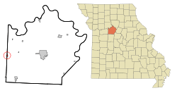 Location of Blackburn, Missouri | |
| Coordinates: 39°6′14″N 93°29′5″W / 39.10389°N 93.48472°WCoordinates: 39°6′14″N 93°29′5″W / 39.10389°N 93.48472°W | |
| Country | United States |
| State | Missouri |
| Counties | Saline, Lafayette |
| Area[1] | |
| • Total | 0.32 sq mi (0.83 km2) |
| • Land | 0.31 sq mi (0.80 km2) |
| • Water | 0.01 sq mi (0.03 km2) |
| Elevation | 794 ft (242 m) |
| Population (2010)[2] | |
| • Total | 249 |
| • Estimate (2012[3]) | 250 |
| • Density | 803.2/sq mi (310.1/km2) |
| Time zone | Central (CST) (UTC-6) |
| • Summer (DST) | CDT (UTC-5) |
| ZIP code | 65321 |
| Area code(s) | 660 |
| FIPS code | 29-05950[4] |
| GNIS feature ID | 0714318[5] |
Blackburn is a city in Lafayette and Saline counties in the U.S. state of Missouri. The population was 249 at the 2010 census.
History
Blackburn was named for M. P. and C. J. Blackburn.[6]
Geography
Blackburn is located at 39°6′14″N 93°29′5″W / 39.10389°N 93.48472°W (39.103980, -93.484771).[7]
According to the United States Census Bureau, the city has a total area of 0.32 square miles (0.83 km2), of which, 0.31 square miles (0.80 km2) is land and 0.01 square miles (0.03 km2) is water.[1]
Demographics
| Historical population | |||
|---|---|---|---|
| Census | Pop. | %± | |
| 1880 | 214 | — | |
| 1890 | 372 | 73.8% | |
| 1900 | 458 | 23.1% | |
| 1910 | 389 | −15.1% | |
| 1920 | 333 | −14.4% | |
| 1930 | 292 | −12.3% | |
| 1940 | 314 | 7.5% | |
| 1950 | 306 | −2.5% | |
| 1960 | 310 | 1.3% | |
| 1970 | 294 | −5.2% | |
| 1980 | 314 | 6.8% | |
| 1990 | 308 | −1.9% | |
| 2000 | 284 | −7.8% | |
| 2010 | 249 | −12.3% | |
| Est. 2015 | 250 | [8] | 0.4% |
2010 census
As of the census[2] of 2010, there were 249 people, 107 households, and 72 families residing in the city. The population density was 803.2 inhabitants per square mile (310.1/km2). There were 124 housing units at an average density of 400.0 per square mile (154.4/km2). The racial makeup of the city was 92.0% White, 3.2% African American, 1.2% from other races, and 3.6% from two or more races. Hispanic or Latino of any race were 2.8% of the population.
There were 107 households of which 29.9% had children under the age of 18 living with them, 57.0% were married couples living together, 7.5% had a female householder with no husband present, 2.8% had a male householder with no wife present, and 32.7% were non-families. 28.0% of all households were made up of individuals and 8.4% had someone living alone who was 65 years of age or older. The average household size was 2.33 and the average family size was 2.82.
The median age in the city was 44.8 years. 22.9% of residents were under the age of 18; 4.3% were between the ages of 18 and 24; 22.8% were from 25 to 44; 30% were from 45 to 64; and 19.7% were 65 years of age or older. The gender makeup of the city was 48.2% male and 51.8% female.
2000 census
As of the census[4] of 2000, there were 284 people, 106 households, and 76 families residing in the city. The population density was 923.4 people per square mile (353.7/km²). There were 126 housing units at an average density of 409.7 per square mile (156.9/km²). The racial makeup of the city was 95.77% White, 1.76% African American, 0.35% Native American, 0.35% Asian, and 1.76% from two or more races. Hispanic or Latino of any race were 2.11% of the population.
There were 106 households out of which 34.0% had children under the age of 18 living with them, 62.3% were married couples living together, 4.7% had a female householder with no husband present, and 28.3% were non-families. 24.5% of all households were made up of individuals and 14.2% had someone living alone who was 65 years of age or older. The average household size was 2.68 and the average family size was 3.24.
In the city the population was spread out with 27.1% under the age of 18, 7.4% from 18 to 24, 26.8% from 25 to 44, 24.6% from 45 to 64, and 14.1% who were 65 years of age or older. The median age was 38 years. For every 100 females there were 100.0 males. For every 100 females age 18 and over, there were 93.5 males.
The median income for a household in the city was $35,313, and the median income for a family was $43,750. Males had a median income of $38,333 versus $21,250 for females. The per capita income for the city was $14,603. About 10.6% of families and 11.8% of the population were below the poverty line, including 7.5% of those under the age of eighteen and 7.9% of those sixty five or over.
References
- 1 2 "US Gazetteer files 2010". United States Census Bureau. Archived from the original on 2012-01-24. Retrieved 2012-07-08.
- 1 2 "American FactFinder". United States Census Bureau. Retrieved 2012-07-08.
- ↑ "Population Estimates". United States Census Bureau. Archived from the original on 2013-06-17. Retrieved 2013-05-30.
- 1 2 "American FactFinder". United States Census Bureau. Archived from the original on 2013-09-11. Retrieved 2008-01-31.
- ↑ "US Board on Geographic Names". United States Geological Survey. 2007-10-25. Retrieved 2008-01-31.
- ↑ Eaton, David Wolfe (1918). How Missouri Counties, Towns and Streams Were Named. The State Historical Society of Missouri. p. 361.
- ↑ "US Gazetteer files: 2010, 2000, and 1990". United States Census Bureau. 2011-02-12. Retrieved 2011-04-23.
- ↑ "Annual Estimates of the Resident Population for Incorporated Places: April 1, 2010 to July 1, 2015". Retrieved July 2, 2016.
- ↑ "Census of Population and Housing". Census.gov. Archived from the original on May 11, 2015. Retrieved June 4, 2015.
Municipalities and communities of Lafayette County, Missouri, United States | ||
|---|---|---|
| Cities | 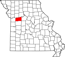 | |
| Villages | ||
| Townships | ||
| Unincorporated communities | ||
| Ghost towns | ||
| Footnotes | ‡This populated place also has portions in an adjacent county or counties | |
Municipalities and communities of Saline County, Missouri, United States | ||
|---|---|---|
| Cities | 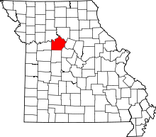 | |
| Villages | ||
| Townships |
| |
| Unincorporated communities | ||
| Footnotes | ‡This populated place also has portions in an adjacent county or counties | |