Emma, Missouri
| Emma, Missouri | |
|---|---|
| City | |
 Location of Emma, Missouri | |
| Coordinates: 38°58′40″N 93°29′38″W / 38.97778°N 93.49389°WCoordinates: 38°58′40″N 93°29′38″W / 38.97778°N 93.49389°W | |
| Country | United States |
| State | Missouri |
| Counties | Saline, Lafayette |
| Area[1] | |
| • Total | 0.43 sq mi (1.11 km2) |
| • Land | 0.43 sq mi (1.11 km2) |
| • Water | 0 sq mi (0 km2) |
| Elevation | 758 ft (231 m) |
| Population (2010)[2] | |
| • Total | 233 |
| • Estimate (2012[3]) | 233 |
| • Density | 541.9/sq mi (209.2/km2) |
| Time zone | Central (CST) (UTC-6) |
| • Summer (DST) | CDT (UTC-5) |
| ZIP code | 65327 |
| Area code(s) | 660 |
| FIPS code | 29-22312[4] |
| GNIS feature ID | 0717578[5] |
Emma is a city in Lafayette and Saline counties in the U.S. state of Missouri. The population was 233 at the 2010 census.
History
The village has the name of Emma Bemetrio, the daughter of a local minister.[6] The Emma post office closed in 1951.[7]
Geography
Emma is located at 38°58′40″N 93°29′38″W / 38.97778°N 93.49389°W (38.977871, -93.493922).[8]
According to the United States Census Bureau, the city has a total area of 0.43 square miles (1.11 km2), all of it land.[1]
Emma is located south of Interstate 70.
Demographics
| Historical population | |||
|---|---|---|---|
| Census | Pop. | %± | |
| 1960 | 202 | — | |
| 1970 | 224 | 10.9% | |
| 1980 | 267 | 19.2% | |
| 1990 | 194 | −27.3% | |
| 2000 | 243 | 25.3% | |
| 2010 | 233 | −4.1% | |
| Est. 2015 | 238 | [9] | 2.1% |
2010 census
As of the census[2] of 2010, there were 233 people, 94 households, and 66 families residing in the city. The population density was 541.9 inhabitants per square mile (209.2/km2). There were 106 housing units at an average density of 246.5 per square mile (95.2/km2). The racial makeup of the city was 98.3% White and 1.7% from two or more races. Hispanic or Latino of any race were 1.7% of the population.
There were 94 households of which 26.6% had children under the age of 18 living with them, 61.7% were married couples living together, 5.3% had a female householder with no husband present, 3.2% had a male householder with no wife present, and 29.8% were non-families. 23.4% of all households were made up of individuals and 11.7% had someone living alone who was 65 years of age or older. The average household size was 2.48 and the average family size was 3.00.
The median age in the city was 42.4 years. 22.3% of residents were under the age of 18; 7.4% were between the ages of 18 and 24; 23.1% were from 25 to 44; 25.8% were from 45 to 64; and 21.5% were 65 years of age or older. The gender makeup of the city was 51.9% male and 48.1% female.
2000 census
As of the census[4] of 2000, there were 243 people, 93 households, and 75 families residing in the city. The population density was 562.3 people per square mile (218.2/km²). There were 98 housing units at an average density of 226.8 per square mile (88.0/km²). The racial makeup of the city was 98.77% White, and 1.23% from two or more races. Hispanic or Latino of any race were 0.82% of the population.
There were 93 households out of which 33.3% had children under the age of 18 living with them, 71.0% were married couples living together, 5.4% had a female householder with no husband present, and 18.3% were non-families. 16.1% of all households were made up of individuals and 10.8% had someone living alone who was 65 years of age or older. The average household size was 2.61 and the average family size was 2.92.
In the city the population was spread out with 26.3% under the age of 18, 7.0% from 18 to 24, 23.5% from 25 to 44, 23.9% from 45 to 64, and 19.3% who were 65 years of age or older. The median age was 39 years. For every 100 females there were 99.2 males. For every 100 females age 18 and over, there were 96.7 males.
The median income for a household in the city was $34,167, and the median income for a family was $47,500. Males had a median income of $28,750 versus $22,917 for females. The per capita income for the city was $14,994. About 7.4% of families and 12.4% of the population were below the poverty line, including 22.4% of those under the age of eighteen and 4.0% of those sixty five or over.
References
- 1 2 "US Gazetteer files 2010". United States Census Bureau. Retrieved 2012-07-08.
- 1 2 "American FactFinder". United States Census Bureau. Retrieved 2012-07-08.
- ↑ "Population Estimates". United States Census Bureau. Retrieved 2013-05-30.
- 1 2 "American FactFinder". United States Census Bureau. Retrieved 2008-01-31.
- ↑ "US Board on Geographic Names". United States Geological Survey. 2007-10-25. Retrieved 2008-01-31.
- ↑ "Lafayette County Place Names, 1928–1945 (archived)". The State Historical Society of Missouri. Retrieved 25 October 2016.
- ↑ "Post Offices". Jim Forte Postal History. Retrieved 25 October 2016.
- ↑ "US Gazetteer files: 2010, 2000, and 1990". United States Census Bureau. 2011-02-12. Retrieved 2011-04-23.
- ↑ "Annual Estimates of the Resident Population for Incorporated Places: April 1, 2010 to July 1, 2015". Retrieved July 2, 2016.
- ↑ "Census of Population and Housing". Census.gov. Retrieved June 4, 2015.
Municipalities and communities of Lafayette County, Missouri, United States | ||
|---|---|---|
| Cities | 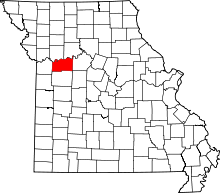 | |
| Villages | ||
| Townships | ||
| Unincorporated communities | ||
| Ghost towns | ||
| Footnotes | ‡This populated place also has portions in an adjacent county or counties | |
Municipalities and communities of Saline County, Missouri, United States | ||
|---|---|---|
| Cities | 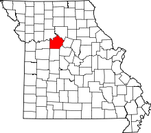 | |
| Villages | ||
| Townships |
| |
| Unincorporated communities | ||
| Footnotes | ‡This populated place also has portions in an adjacent county or counties | |