Lexington, Missouri
| Lexington, Missouri | |
|---|---|
| City | |
|
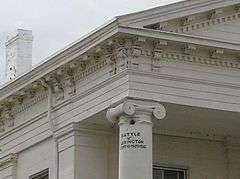
Lexington Historical Museum | |
 Location of Lexington, Missouri | |
| Coordinates: 39°10′59″N 93°52′30″W / 39.18306°N 93.87500°WCoordinates: 39°10′59″N 93°52′30″W / 39.18306°N 93.87500°W | |
| Country | United States |
| State | Missouri |
| County | Lafayette |
| Government | |
| • Mayor | Jerry Brown |
| Area[1] | |
| • Total | 5.38 sq mi (13.93 km2) |
| • Land | 5.15 sq mi (13.34 km2) |
| • Water | 0.23 sq mi (0.60 km2) |
| Elevation | 850 ft (259 m) |
| Population (2010)[2] | |
| • Total | 4,726 |
| • Estimate (2012[3]) | 4,667 |
| • Density | 917.7/sq mi (354.3/km2) |
| Time zone | Central (CST) (UTC-6) |
| • Summer (DST) | CDT (UTC-5) |
| ZIP code | 64067 |
| Area code(s) | 660 |
| FIPS code | 29-41870[4] |
| GNIS feature ID | 0720950[5] |
| Website | Lexington, Missouri |

Lexington is a city in Lafayette County, Missouri, United States. The population was 4,726 at the 2010 census. It is the county seat of Lafayette County.[6] Located in western Missouri, Lexington lies about 40 miles east of Kansas City and is part of the Greater Kansas City Metropolitan Area. It is the home of the Battle of Lexington State Historic Site, and Wentworth Military Academy and College, the oldest military school west of the Mississippi River opened in 1880.[7]
Geography
Lexington is located at 39°10′59″N 93°52′30″W / 39.18306°N 93.87500°W (39.183060, -93.875070).[8] 342343456489705439. According to the United States Census Bureau, the city has a total area of 5.38 square miles (13.93 km2), of which, 5.15 square miles (13.34 km2) is land and 0.23 square miles (0.60 km2) is water.[1]
Demographics
| Historical population | |||
|---|---|---|---|
| Census | Pop. | %± | |
| 1850 | 2,698 | — | |
| 1860 | 4,122 | 52.8% | |
| 1870 | 4,373 | 6.1% | |
| 1880 | 3,996 | −8.6% | |
| 1890 | 4,537 | 13.5% | |
| 1900 | 4,190 | −7.6% | |
| 1910 | 5,242 | 25.1% | |
| 1920 | 4,695 | −10.4% | |
| 1930 | 4,595 | −2.1% | |
| 1940 | 5,341 | 16.2% | |
| 1950 | 5,074 | −5.0% | |
| 1960 | 4,845 | −4.5% | |
| 1970 | 5,388 | 11.2% | |
| 1980 | 5,063 | −6.0% | |
| 1990 | 4,860 | −4.0% | |
| 2000 | 4,453 | −8.4% | |
| 2010 | 4,726 | 6.1% | |
| Est. 2015 | 4,598 | [9] | −2.7% |
2010 census
As of the census[2] of 2010, there were 4,726 people, 1,867 households, and 1,201 families residing in the city. The population density was 917.7 inhabitants per square mile (354.3/km2). There were 2,127 housing units at an average density of 413.0 per square mile (159.5/km2). The racial makeup of the city was 87.3% White, 6.1% African American, 0.5% Native American, 0.9% Asian, 0.7% Pacific Islander, 1.2% from other races, and 3.4% from two or more races. Hispanic or Latino of any race were 3.7% of the population.
There were 1,867 households of which 32.4% had children under the age of 18 living with them, 45.5% were married couples living together, 13.3% had a female householder with no husband present, 5.5% had a male householder with no wife present, and 35.7% were non-families. 31.1% of all households were made up of individuals and 13.5% had someone living alone who was 65 years of age or older. The average household size was 2.38 and the average family size was 2.94.
The median age in the city was 39.6 years. 23.8% of residents were under the age of 18; 9.6% were between the ages of 18 and 24; 23.5% were from 25 to 44; 26.1% were from 45 to 64; and 17% were 65 years of age or older. The gender makeup of the city was 48.9% male and 51.1% female.
2000 census
As of the census[4] of 2000, there were 4,453 people, 1,815 households, and 1,210 families residing in the city. The population density was 1,279.7 people per square mile (494.1/km²). There were 2,015 housing units at an average density of 579.1 per square mile (223.6/km²). The racial makeup of the city was 91.02% White, 6.04% African American, 0.18% Native American, 0.49% Asian, 0.04% Pacific Islander, 1.06% from other races, and 1.17% from two or more races. Hispanic or Latino of any race were 2.18% of the population.
There were 1,815 households out of which 31.1% had children under the age of 18 living with them, 48.9% were married couples living together, 13.3% had a female householder with no husband present, and 33.3% were non-families. 30.0% of all households were made up of individuals and 15.0% had someone living alone who was 65 years of age or older. The average household size was 2.37 and the average family size was 2.90.
In the city the population was spread out with 25.2% under the age of 18, 8.0% from 18 to 24, 26.0% from 25 to 44, 22.7% from 45 to 64, and 18.0% who were 65 years of age or older. The median age was 38 years. For every 100 females there were 89.2 males. For every 100 females age 18 and over, there were 85.7 males.
The median income for a household in the city was $32,759, and the median income for a family was $39,583. Males had a median income of $31,672 versus $21,646 for females. The per capita income for the city was $17,879. About 12.8% of families and 14.9% of the population were below the poverty line, including 22.1% of those under age 18 and 11.5% of those age 65 or over.
History
Founding
Lexington, Missouri, located on the bluffs of the Missouri River, was platted in 1822,[11] near William Jack's Ferry, which had been established three years earlier on the south bank of the river. It was named in commemoration of the Battle of Lexington.[12] The first ferry was established in 1819 by Lexington's founder, Gilead Rupe. In 1823, Lexington became the county seat of Lafayette County and grew rapidly.
Growth as a trading center
John Aull opened a mercantile store in 1822, and he was soon joined by his brothers James and Robert Aull. The Aull Brothers firm soon had a frontier chain, also operating stores in Independence, Westport, and Liberty. Other merchants came, as did farmers and planters who specialized in hemp, tobacco and cattle.
With the emphasis on trade and agriculture, Lexington and Lafayette County also had one of the largest slave populations in the state. Many homes in town still have the old slave quarters behind them.
Lexington was a bustling and prosperous city, the largest city west of St. Louis in the 1830s and '40's. During that period, it was the major center for merchants and outfitters as trappers, traders, and emigrants prepared to travel westward on the Santa Fe Trail, California Trail, Oregon Trail, and the Mormon Trail to Utah. Goods sent west from Lexington were valued at $450,000 in 1843. Rope walks, slaughter houses, a foundry and a furniture factory were among other early Lexington industries. In the 1840s, Russell, Majors and Waddell, the largest trading firm in the West, established its headquarters on Main Street. In the 1850s, these three men had 3500 wagons carrying goods from Missouri to Sacramento, Denver, and other points, and in 1860, they would found the Pony Express.
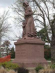
The steamboat trade on the river became a hugely profitable investment, and the wharf was a center of commerce. In 1852, one of the worst steamboat accidents in Missouri history occurred at Lexington. The side-wheeler Saluda (steamship) was carrying 250 Mormons en route to Salt Lake City when its boilers exploded, killing over 150 people. Many children orphaned by the blast were adopted by Lexingtonians. Productive coal mines, among the first in the state, were dug into the surrounding river bluffs to provide fuel for river steamers.
Architecture
Lexington was also noted for its architecture, especially in its public buildings. The Greek Revival Lafayette County Courthouse, built in 1847 on Main Street, is the oldest courthouse in continuous use west of the Mississippi. The Masonic College, also built in the Greek Revival style, operated from 1847 to 1857, and after the Civil War, it housed the Central College for Women. The Gothic Revival Christ Episcopal Church, built in 1848, has an interior finished in walnut and a ceiling ornamented with a Gothic truss arch. Lexington is still home to over 150 homes and public buildings built before the Civil War, and annually holds well-attended tours of its historic homes and buildings.
Civil War and aftermath
Lexington was the site of two of the largest battles in the western campaign of the American Civil War. The better-known Battle of Lexington is commonly referred to as the Battle of the Hemp Bales. On September 12, 1861, between 6,000 and 10,000 soldiers of the Missouri State Guard, led by Major General Sterling Price, began a siege against the Federal military post in the old Masonic College commanded by Colonel James A. Mulligan.
On September 18, Price's army mounted an assault. Some of Price's army used hemp bales as moving breastworks while they moved up the river bluffs and closed in on Mulligan's headquarters. On September 20, 1861, Mulligan's troops surrendered. Combined casualties were 73 dead, 270 wounded. The battlefield on the bluffs of the Missouri River is now a state park, and the cannonball stuck in one of the upper pillars of the Courthouse has become a symbol for the town.
The Second Battle of Lexington occurred during Price's Missouri Expedition on October 19, 1864.
Lexington was known as a center for Quantrill's Raiders during the war. Two months after the Civil War ended, many of these guerrilla fighters who had refused to honor the cease fire finally decided to take advantage of the special Federal amnesty that was declared for such forces and turn themselves in at Lexington. While riding into town, reportedly under a white flag, they were fired upon by Union soldiers from the 2nd Wisconsin Cavalry, and Jesse James was severely wounded in the right lung. Some credit this event as a major contributing factor to his post-war career as a legendary bank robber. It is likely not a coincidence that the James-Younger Gang targeted the Alexander Mitchell bank in Lexington for the second daylight bank robbery in United States history. In December 1866, Archie Clement, an accomplice of the James brothers and perhaps the most notorious of all the guerrilla fighters, terrorized the town and was shot from his horse and killed by a sniper perched in the second floor of the Courthouse.
Athens of the West
Lexington never returned to its pre-war prominence, replaced by Kansas City as the most important city in western Missouri. Particularly harmful was arrival of the transcontinental railroad, which supplanted the river commerce. A number of institutions of higher education were established, leading the town to bill itself as the “Athens of the West.”. Especially significant were three schools for women, the Elizabeth Aull Seminary, Lexington Ladies College, and Central College for Women. Wentworth Military Academy, founded in 1880, still draws students from throughout the country and around the world today.
Lexington businesses
Until the 1980s Lexington was the headquarters and main distribution point for Mattingly's/Matco Stores, which was purchased by P.M. Place Stores. In 2000 the Place's stores were purchased by ShopKo to be converted into Pamida stores. In 2004 the former Mattingly warehouse was sold by Pamida. In August 2004 liquidation of the former Matco #101, then a Pamida, began and the store was closed by the end of October. This was the end of the Mattingly store legacy in Lexington. Hugh Mattingly had been a mentor to Wal-Mart founder, Sam Walton.
Lexington is a location for the Maid-Rite restaurant franchise, famous in the midwestern United States for its loose meat hamburgers and other traditional diner fare.
Dunbrooke began as a dress shirt company in 1939 in Lexington, Missouri has grown to become one of the nation’s premiere logoed apparel manufacturers. Over the past 65 years, the company has borne witness to several changes, encompassing everything from its products to its name. The company has manufactured several types of apparel, from dress shirts to bowling shirts to nylon gym shorts and jackets. Dunbrooke’s signature jacket line had its beginnings in the 1950s when the company was under government contract to produce nylon jackets for the Korean War. The company’s name also underwent several transformations from its original name “Dunhill” (1939) to “Dunbrooke Shirt Company” (1963) to “Dunbrooke Sportswear” (1971) to Dunbrooke Apparel Corp (2003). The current managers purchased Dunbrooke from parent company American Marketing Industries (AMI) in October 2003. Under its new ownership, Dunbrooke today maintains two offices – corporate headquarters in Independence, MO, and a modern decorating and distribution center located in El Dorado Springs, MO, built in 1998
Notable residents
Government
- Ike Skelton - Congressman, 1977-2011.
- Thomas B. Catron, United States Senator.
- Thomas Peter Akers – Congressman, 1856-57.
- Atterson W. Rucker – Lawyer, Congressman.
- John P. Campbell, Jr. – Lawyer, Congressman, 1848-1852.
- John Telemachus Johnson – Congressman
- Mark L. De Motte – Lawyer, Editor of the Lexington Register, Congressman
- Alexander Graves – Lawyer, Congressman, 1883–1885
- Samuel Locke Sawyer – Lawyer, Congressman, 1879–1881
- Frank L. Houx – Lawyer, Governor of Wyoming
- John Welborn (representative) - Lawyer, Congressman, 1905-1907.
Business
- William B. Waddell – Freighter, partner in Russell, Majors and Waddell, founder of the Pony Express
- William Hepburn Russell – Freighter, partner in Russell, Majors and Waddell, founder of the Pony Express
- Sam Walton - Founder of Wal-Mart
- James "Bud" Walton - Co-founder of Wal-Mart
- William C. Schwartz - Physicist, Laser pioneer, and founder of International Laser Systems
Athletics
- Med Park - NBA basketball player
- Lenvil Elliott - NFL football player
- Ron Tabb - Professional long distance runner
- Chris Banks - NFL football player for 1998 Super Bowl champion Denver Broncos
Military
- Alexander William Doniphan – Lawyer, U.S.-Mexican War hero
- William M. Hoge - oversaw construction of the ALCAN Highway and directed capture of the Remagen Bridge in World War II
- Harold G. Schrier – Helped raise flag over Iwo Jima.
Arts and entertainment
- Carleton Coon, an American jazz musician, co-founder of the Coon-Sanders Original Nighthawk Orchestra
- Carl Stalling – Composer and Arranger for the Bugs Bunny and other Looney Tunes cartoons from the 1930s through the 1950s.
- James Lane Allen - Author
- George Kriehn – American writer and lecturer on art.
- Nick Corporon - American filmmaker/director
Academia
- Stephen G. Wentworth – Banker, Founder of Wentworth Military Academy
- Sandford Sellers – President of Wentworth Military Academy, 1880-1938.
- Ovid R. Sellers - internationally known Old Testament scholar and archaeologist
- James M. Sellers – Commandant, Superintendent, and President of Wentworth Military Academy, 1920-1990.
- James M. Sellers, Jr. – Superintendent of Wentworth Military Academy, 1973-1990.
- Lester B. Wikoff – Athletic Director, Treasurer, and Superintendent of Wentworth Military Academy, 1915-1971.
- John H. Little - Superintendent of Wentworth Military Academy, 2002-2007.
- William W. Sellers – President of Wentworth Military Academy, 2008–2013.
Outlaws
- Archie Clement – Notorious guerrilla outlaw, killed in Lexington in 1866
- Jesse James – Wounded while going to surrender in Lexington, 1865. Committed second daylight bank robbery in Lexington, 1866.
- John Newman Edwards – Publisher of the Lexington Expositor, Creator of the Jesse James legend.
- Hoodoo Brown – leader of the Dodge City Gang in Las Vegas, New Mexico.
Religion
- Judith Craig - American Bishop of the United Methodist Church.
- Thomas Francis Lillis - former Roman Catholic Bishop
See also
References
- 1 2 "US Gazetteer files 2010". United States Census Bureau. Archived from the original on January 24, 2012. Retrieved 2012-07-08.
- 1 2 "American FactFinder". United States Census Bureau. Retrieved 2012-07-08.
- ↑ "Population Estimates". United States Census Bureau. Archived from the original on June 17, 2013. Retrieved 2013-05-30.
- 1 2 "American FactFinder". United States Census Bureau. Archived from the original on September 11, 2013. Retrieved 2008-01-31.
- ↑ "US Board on Geographic Names". United States Geological Survey. 2007-10-25. Retrieved 2008-01-31.
- ↑ "Find a County". National Association of Counties. Archived from the original on May 31, 2011. Retrieved 2011-06-07.
- ↑ History of Wentworth Military Academy, by James M. Sellers, Jr., 1984.
- ↑ "US Gazetteer files: 2010, 2000, and 1990". United States Census Bureau. 2011-02-12. Retrieved 2011-04-23.
- ↑ "Annual Estimates of the Resident Population for Incorporated Places: April 1, 2010 to July 1, 2015". Retrieved July 2, 2016.
- ↑ "Census of Population and Housing". Census.gov. Archived from the original on May 11, 2015. Retrieved June 4, 2015.
- ↑ "Lafayette County Place Names, 1928–1945 (archived)". The State Historical Society of Missouri. Retrieved 24 October 2016.
- ↑ Eaton, David Wolfe (1916). How Missouri Counties, Towns and Streams Were Named. The State Historical Society of Missouri. p. 183.
- The Battle of Lexington, Fought in and About the City of Lexington, Missouri on September 18, 19 and 20th, 1861. Lexington Historical Society. 1903.
- Lexington, Missouri Sesquicentennial Commemorative Book, 1972.
External links
| Wikimedia Commons has media related to Lexington, Missouri. |
| Wikisource has the text of a 1911 Encyclopædia Britannica article about Lexington, Missouri. |
- Lexington Area Chamber of Commerce
- Lexington Tourism Bureau
- Lexington Economic Development Council
- Historic maps of Lexington in the Sanborn Maps of Missouri Collection at the University of Missouri
Municipalities and communities of Lafayette County, Missouri, United States | ||
|---|---|---|
| Cities | 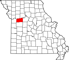 | |
| Villages | ||
| Townships | ||
| Unincorporated communities | ||
| Ghost towns | ||
| Footnotes | ‡This populated place also has portions in an adjacent county or counties | |