Breckenridge, Minnesota
| Breckenridge, Minnesota | |
|---|---|
| City | |
|
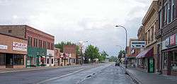
5th Street (U.S. Route 75) in downtown Breckenridge in 2007 | |
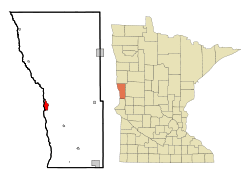 Location of Breckenridge within Wilkin County and state of Minnesota | |
| Coordinates: 46°16′N 96°35′W / 46.267°N 96.583°W | |
| Country | United States |
| State | Minnesota |
| County | Wilkin |
| Area[1] | |
| • Total | 2.46 sq mi (6.37 km2) |
| • Land | 2.46 sq mi (6.37 km2) |
| • Water | 0 sq mi (0 km2) |
| Elevation | 961 ft (293 m) |
| Population (2010)[2] | |
| • Total | 3,386 |
| • Estimate (2014[3]) | 3,340 |
| • Density | 1,376.4/sq mi (531.4/km2) |
| Time zone | Central (CST) (UTC-6) |
| • Summer (DST) | CDT (UTC-5) |
| ZIP code | 56520 |
| Area code(s) | 218 |
| FIPS code | 27-07462 |
| GNIS feature ID | 0640448[4] |
| Website | breckenridgemn.net |
Breckenridge is a city and county seat of Wilkin County, Minnesota, United States.[5] The population was 3,386 at the 2010 census.[6]
Breckenridge's twin city is Wahpeton, North Dakota. It is part of the Wahpeton, ND–MN Micropolitan Statistical Area. The Bois de Sioux River and the Otter Tail River join at Breckenridge and Wahpeton to form the Red River of the North.
History
Breckenridge was platted in 1857, and named for John C. Breckinridge, Senator from Kentucky, and fourteenth Vice President of the United States.[7] A post office has been in operation at Breckenridge since 1857.[8] Breckenridge was incorporated in 1908.[7]
Geography
According to the United States Census Bureau, the city has a total area of 2.46 square miles (6.37 km2), all of it land.[1]
U.S. Route 75 and Minnesota State Highways 9 and 210 are three of the main routes in the city.
Demographics
| Historical population | |||
|---|---|---|---|
| Census | Pop. | %± | |
| 1890 | 655 | — | |
| 1900 | 1,282 | 95.7% | |
| 1910 | 1,840 | 43.5% | |
| 1920 | 2,401 | 30.5% | |
| 1930 | 2,261 | −5.8% | |
| 1940 | 2,745 | 21.4% | |
| 1950 | 3,623 | 32.0% | |
| 1960 | 4,335 | 19.7% | |
| 1970 | 4,200 | −3.1% | |
| 1980 | 3,909 | −6.9% | |
| 1990 | 3,708 | −5.1% | |
| 2000 | 3,559 | −4.0% | |
| 2010 | 3,386 | −4.9% | |
| Est. 2015 | 3,290 | [9] | −2.8% |
| U.S. Decennial Census[10] 2013 Estimate[11] | |||
2010 census
As of the census[2] of 2010, there were 3,386 people, 1,445 households, and 861 families residing in the city. The population density was 1,376.4 inhabitants per square mile (531.4/km2). There were 1,635 housing units at an average density of 664.6 per square mile (256.6/km2). The racial makeup of the city was 96.3% White, 0.2% African American, 1.4% Native American, 0.4% Asian, 0.3% from other races, and 1.4% from two or more races. Hispanic or Latino of any race were 2.5% of the population.
There were 1,445 households of which 27.4% had children under the age of 18 living with them, 47.5% were married couples living together, 7.8% had a female householder with no husband present, 4.3% had a male householder with no wife present, and 40.4% were non-families. 36.2% of all households were made up of individuals and 15.5% had someone living alone who was 65 years of age or older. The average household size was 2.24 and the average family size was 2.91.
The median age in the city was 43.3 years. 23.3% of residents were under the age of 18; 7.4% were between the ages of 18 and 24; 21.2% were from 25 to 44; 26.8% were from 45 to 64; and 21.2% were 65 years of age or older. The gender makeup of the city was 49.0% male and 51.0% female.
2000 census
As of the census of 2000, there were 3,559 people, 1,438 households, and 911 families residing in the city. The population density was 1,516.4 people per square mile (584.7/km²). There were 1,582 housing units at an average density of 674.0 per square mile (259.9/km²). The racial makeup of the city was 97.61% White, 0.14% African American, 0.56% Native American, 0.17% Asian, 0.03% Pacific Islander, 0.39% from other races, and 1.10% from two or more races. Hispanic or Latino of any race were 1.71% of the population.
There were 1,438 households out of which 33.4% had children under the age of 18 living with them, 51.8% were married couples living together, 9.2% had a female householder with no husband present, and 36.6% were non-families. 31.7% of all households were made up of individuals and 16.6% had someone living alone who was 65 years of age or older. The average household size was 2.38 and the average family size was 3.05.
In the city the population was spread out with 26.6% under the age of 18, 7.9% from 18 to 24, 27.1% from 25 to 44, 19.8% from 45 to 64, and 18.7% who were 65 years of age or older. The median age was 38 years. For every 100 females there were 87.5 males. For every 100 females age 18 and over, there were 86.2 males.
The median income for a household in the city was $37,054, and the median income for a family was $47,500. Males had a median income of $31,869 versus $21,328 for females. The per capita income for the city was $17,059. About 7.3% of families and 9.0% of the population were below the poverty line, including 9.5% of those under age 18 and 11.5% of those age 65 or over.
Notable people
- Dick Enderle, professional football player
- Heidi Heitkamp, US Senator from North Dakota
- Chuck Klosterman, writer and novelist
- Errol Mann, professional football player, member of the Oakland Raiders Super Bowl XI team
- George Putnam, radio newsman
- Fritz Scholder, Native American artist
- Gerry Sikorski, politician
- Cheryl Tiegs, professional model
- Adrian P. Winkel, High Commissioner of the Trust Territory of the Pacific Islands
References
- 1 2 "US Gazetteer files 2010". United States Census Bureau. Archived from the original on 2012-01-24. Retrieved 2012-11-13.
- 1 2 "American FactFinder". United States Census Bureau. Retrieved 2012-11-13.
- ↑ "Population Estimates". United States Census Bureau. Retrieved 2014-06-08.
- ↑ "US Board on Geographic Names". United States Geological Survey. 2007-10-25. Retrieved 2008-01-31.
- ↑ "Find a County". National Association of Counties. Archived from the original on 2011-06-15. Retrieved 2011-06-07.
- ↑ "2010 Census Redistricting Data (Public Law 94-171) Summary File". American FactFinder. U.S. Census Bureau, 2010 Census. Archived from the original on 21 July 2011. Retrieved 23 April 2011.
- 1 2 Upham, Warren (1920). Minnesota Geographic Names: Their Origin and Historic Significance. Minnesota Historical Society. p. 578.
- ↑ "Wilkin County". Jim Forte Postal History. Retrieved 14 August 2015.
- ↑ "Annual Estimates of the Resident Population for Incorporated Places: April 1, 2010 to July 1, 2015". Retrieved July 2, 2016.
- ↑ United States Census Bureau. "Census of Population and Housing". Archived from the original on May 11, 2015. Retrieved September 10, 2013.
- ↑ "Annual Estimates of the Resident Population: April 1, 2010 to July 1, 2012". Retrieved June 8, 2014.
External links
-
 Media related to Breckenridge, Minnesota at Wikimedia Commons
 - City of Breckenridge
Municipalities and communities of Wilkin County, Minnesota, United States | ||
|---|---|---|
| Cities | 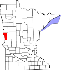 | |
| Townships | ||
| Unincorporated communities | ||
| Footnotes | ‡This populated place also has portions in an adjacent county or counties | |