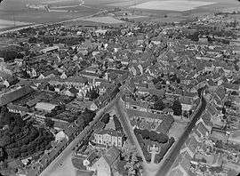
Courville-sur-Eure
| Courville-sur-Eure | ||
|---|---|---|
 | ||
| ||
 Courville-sur-Eure | ||
|
Location within Centre-Val de Loire region  Courville-sur-Eure | ||
| Coordinates: 48°27′03″N 1°14′28″E / 48.4508°N 1.2411°ECoordinates: 48°27′03″N 1°14′28″E / 48.4508°N 1.2411°E | ||
| Country | France | |
| Region | Centre-Val de Loire | |
| Department | Eure-et-Loir | |
| Arrondissement | Chartres | |
| Canton | Courville-sur-Eure | |
| Intercommunality | Pays Courvillois | |
| Government | ||
| • Mayor (2008–2014) | Bernard Gautier | |
| Area1 | 11.13 km2 (4.30 sq mi) | |
| Population (2008)2 | 2,758 | |
| • Density | 250/km2 (640/sq mi) | |
| Time zone | CET (UTC+1) | |
| • Summer (DST) | CEST (UTC+2) | |
| INSEE/Postal code | 28116 / 28190 | |
| Elevation | 155–194 m (509–636 ft) | |
|
1 French Land Register data, which excludes lakes, ponds, glaciers > 1 km² (0.386 sq mi or 247 acres) and river estuaries. 2 Population without double counting: residents of multiple communes (e.g., students and military personnel) only counted once. | ||
.svg.png)
Courville-sur-Eure is a commune in the Eure-et-Loir department in France.
Population
| Historical population | ||
|---|---|---|
| Year | Pop. | ±% |
| 1962 | 1,900 | — |
| 1968 | 1,972 | +3.8% |
| 1975 | 2,030 | +2.9% |
| 1982 | 2,260 | +11.3% |
| 1990 | 2,375 | +5.1% |
| 1999 | 2,739 | +15.3% |
| 2008 | 2,758 | +0.7% |
See also
References
External links
| Wikimedia Commons has media related to Courville-sur-Eure. |
This article is issued from Wikipedia - version of the 7/20/2016. The text is available under the Creative Commons Attribution/Share Alike but additional terms may apply for the media files.