Maillebois
| Maillebois | ||
|---|---|---|
|
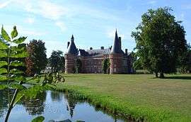
Chateau | ||
| ||
 Maillebois | ||
|
Location within Centre-Val de Loire region  Maillebois | ||
| Coordinates: 48°37′48″N 1°08′57″E / 48.63°N 1.1492°ECoordinates: 48°37′48″N 1°08′57″E / 48.63°N 1.1492°E | ||
| Country | France | |
| Region | Centre-Val de Loire | |
| Department | Eure-et-Loir | |
| Arrondissement | Dreux | |
| Canton | Châteauneuf-en-Thymerais | |
| Intercommunality | Thymerais | |
| Government | ||
| • Mayor (2008–2014) | Vincent Gajas | |
| Area1 | 41 km2 (16 sq mi) | |
| Population (2008)2 | 990 | |
| • Density | 24/km2 (63/sq mi) | |
| Time zone | CET (UTC+1) | |
| • Summer (DST) | CEST (UTC+2) | |
| INSEE/Postal code | 28226 / 28170 | |
| Elevation |
137–191 m (449–627 ft) (avg. 165 m or 541 ft) | |
|
1 French Land Register data, which excludes lakes, ponds, glaciers > 1 km² (0.386 sq mi or 247 acres) and river estuaries. 2 Population without double counting: residents of multiple communes (e.g., students and military personnel) only counted once. | ||

Maillebois is a commune in the Eure-et-Loir department in northern France.
Population
| Historical population | ||
|---|---|---|
| Year | Pop. | ±% |
| 1962 | 1,040 | — |
| 1968 | 770 | −26.0% |
| 1975 | 843 | +9.5% |
| 1982 | 828 | −1.8% |
| 1990 | 821 | −0.8% |
| 1999 | 917 | +11.7% |
| 2008 | 990 | +8.0% |
See also
References
| Wikimedia Commons has media related to Maillebois. |
This article is issued from Wikipedia - version of the 11/19/2013. The text is available under the Creative Commons Attribution/Share Alike but additional terms may apply for the media files.