Nottonville
| Nottonville | |
|---|---|
|
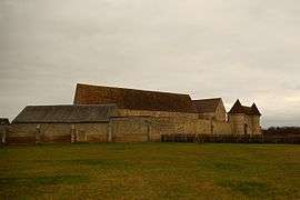
Abbey | |
 Nottonville | |
|
Location within Centre-Val de Loire region  Nottonville | |
| Coordinates: 48°06′47″N 1°30′23″E / 48.1131°N 1.5064°ECoordinates: 48°06′47″N 1°30′23″E / 48.1131°N 1.5064°E | |
| Country | France |
| Region | Centre-Val de Loire |
| Department | Eure-et-Loir |
| Arrondissement | Châteaudun |
| Canton | Orgères-en-Beauce |
| Intercommunality | Beauce d'Orgères |
| Government | |
| • Mayor (2001–2008) | Jacky Tessier |
| Area1 | 24.74 km2 (9.55 sq mi) |
| Population (2008)2 | 287 |
| • Density | 12/km2 (30/sq mi) |
| Time zone | CET (UTC+1) |
| • Summer (DST) | CEST (UTC+2) |
| INSEE/Postal code | 28283 / 28140 |
| Elevation |
112–143 m (367–469 ft) (avg. 130 m or 430 ft) |
|
1 French Land Register data, which excludes lakes, ponds, glaciers > 1 km² (0.386 sq mi or 247 acres) and river estuaries. 2 Population without double counting: residents of multiple communes (e.g., students and military personnel) only counted once. | |
Nottonville is a commune in the Eure-et-Loir department in northern France.
Population
| Historical population | ||
|---|---|---|
| Year | Pop. | ±% |
| 1962 | 363 | — |
| 1968 | 400 | +10.2% |
| 1975 | 343 | −14.2% |
| 1982 | 325 | −5.2% |
| 1990 | 275 | −15.4% |
| 1999 | 252 | −8.4% |
| 2008 | 287 | +13.9% |
See also
References
| Wikimedia Commons has media related to Nottonville. |
This article is issued from Wikipedia - version of the 2/23/2015. The text is available under the Creative Commons Attribution/Share Alike but additional terms may apply for the media files.