Saint-Prest
| Saint-Prest | |
|---|---|
|
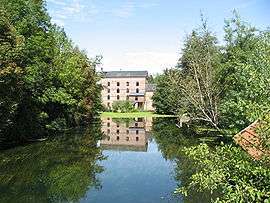
Mill | |
 Saint-Prest | |
|
Location within Centre-Val de Loire region  Saint-Prest | |
| Coordinates: 48°29′35″N 1°31′54″E / 48.4931°N 1.5317°ECoordinates: 48°29′35″N 1°31′54″E / 48.4931°N 1.5317°E | |
| Country | France |
| Region | Centre-Val de Loire |
| Department | Eure-et-Loir |
| Arrondissement | Chartres |
| Canton | Chartres-Nord-Est |
| Government | |
| • Mayor (2008–2014) | Jean-Marc Cavet |
| Area1 | 16.71 km2 (6.45 sq mi) |
| Population (2008)2 | 2,100 |
| • Density | 130/km2 (330/sq mi) |
| Time zone | CET (UTC+1) |
| • Summer (DST) | CEST (UTC+2) |
| INSEE/Postal code | 28358 / 28300 |
| Elevation |
112–165 m (367–541 ft) (avg. 124 m or 407 ft) |
|
1 French Land Register data, which excludes lakes, ponds, glaciers > 1 km² (0.386 sq mi or 247 acres) and river estuaries. 2 Population without double counting: residents of multiple communes (e.g., students and military personnel) only counted once. | |
Saint-Prest is a commune in the Eure-et-Loir department in northern France.
Population
| Historical population | ||
|---|---|---|
| Year | Pop. | ±% |
| 1962 | 991 | — |
| 1968 | 1,118 | +12.8% |
| 1975 | 1,224 | +9.5% |
| 1982 | 1,483 | +21.2% |
| 1990 | 2,200 | +48.3% |
| 1999 | 2,260 | +2.7% |
| 2008 | 2,100 | −7.1% |
See also
References
| Wikimedia Commons has media related to Saint-Prest. |
This article is issued from Wikipedia - version of the 11/22/2013. The text is available under the Creative Commons Attribution/Share Alike but additional terms may apply for the media files.