Lumeau
| Lumeau | |
|---|---|
 Lumeau | |
|
Location within Centre-Val de Loire region  Lumeau | |
| Coordinates: 48°07′00″N 1°47′11″E / 48.1167°N 1.7864°ECoordinates: 48°07′00″N 1°47′11″E / 48.1167°N 1.7864°E | |
| Country | France |
| Region | Centre-Val de Loire |
| Department | Eure-et-Loir |
| Arrondissement | Châteaudun |
| Canton | Orgères-en-Beauce |
| Intercommunality | Beauce d'Orgères |
| Government | |
| • Mayor (2008–2014) | Charlie Peillon |
| Area1 | 15.28 km2 (5.90 sq mi) |
| Population (2008)2 | 187 |
| • Density | 12/km2 (32/sq mi) |
| Time zone | CET (UTC+1) |
| • Summer (DST) | CEST (UTC+2) |
| INSEE/Postal code | 28221 / 28140 |
| Elevation |
120–134 m (394–440 ft) (avg. 123 m or 404 ft) |
|
1 French Land Register data, which excludes lakes, ponds, glaciers > 1 km² (0.386 sq mi or 247 acres) and river estuaries. 2 Population without double counting: residents of multiple communes (e.g., students and military personnel) only counted once. | |
Lumeau is a commune in the Eure-et-Loir department in northern France, between Chartres and Orléans.
Geography
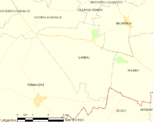
Lumeau is situated in the Beauce agricultural plain, 34 km north from Orléans, 39 km north-east from Châteaudun, 50 km south of Chartres and 111 km south of Paris.
History
Lumeau has roots as a Gaulish village in the Carnutes territory. It was inhabited long before Roman times. Lumeau name derives from the Gallic elm (Ulmus) and is of Celtic origin. It is crossed by an old Roman road. It is cited in an Act of Charles the Bald (about AD 877).
In 1963, in Neuvilliers hamlet of Lumeau, a tomb was discovered, including a gallery and a circular room dated 12th century, which are certainly a part of a very important network dating from the Middle Ages.
During the Hundred Years' War, especially in 1361, the British occupied the nearby castle.
From 1785 to 1792 isolated farms suffered attacks from a criminal gang referred to as the 'Chauffeurs d'Orgères' (burners from Orgères).
During the Franco-Prussian War of 1870, Lumeau is in the middle of the Loigny-Poupry battlefield, between the French Armée de la Loire and the Bavarian and Prussian troops. The battle spread over the municipalities of Guillonville, Loigny, Lumeau and Poupry on 2 December 1870. Lumeau is mainly involved in combat events from November 29 to December 3, 1870, while further rescue activities take place from December 2, 1870 to February 18, 1871. A memorial was built in 1873 in Neuvilliers hamlet where French troop stationed : this is a white obelisk with a height of eight meters over an ossuary (containing thousands human remains) under a granite basement surrounded by a chain.
Population
| Historical population | ||
|---|---|---|
| Year | Pop. | ±% |
| 1793 | 484 | — |
| 1800 | 413 | −14.7% |
| 1851 | 501 | +21.3% |
| 1901 | 482 | −3.8% |
| 1946 | 320 | −33.6% |
| 1954 | 313 | −2.2% |
| 1962 | 267 | −14.7% |
| 1968 | 297 | +11.2% |
| 1975 | 229 | −22.9% |
| 1982 | 194 | −15.3% |
| 1990 | 179 | −7.7% |
| 1999 | 177 | −1.1% |
| 2008 | 187 | +5.6% |

Transport
The distances between Lumeau and its neighbouring towns is as follows:
- Loigny-la-Bataille 4 km
- Poupry 4 km
- Terminiers 5 km
- Artenay 8 km
- Road accès from motorway A10 (8 km from exit 13), from roads N20/D2020, N&54/D954, D10, D3.9, D19
- Train station at Artenay : TER Centre-Val de Loire (line from Paris-Austerlitz to Orléans)
- Public transport : Transbeauce ligne 2 Orléans- Chartres
See also
References
| Wikimedia Commons has media related to Lumeau. |