Ymonville
| Ymonville | |
|---|---|
|
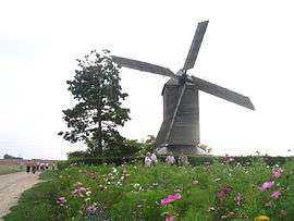
Moulin de la Garenne post mill | |
 Ymonville | |
|
Location within Centre-Val de Loire region  Ymonville | |
| Coordinates: 48°15′45″N 1°45′04″E / 48.2625°N 1.7511°ECoordinates: 48°15′45″N 1°45′04″E / 48.2625°N 1.7511°E | |
| Country | France |
| Region | Centre-Val de Loire |
| Department | Eure-et-Loir |
| Arrondissement | Chartres |
| Canton | Voves |
| Intercommunality | Beauce vovéenne |
| Government | |
| • Mayor (2001–2008) | Jean-François Levassor |
| Area1 | 20.69 km2 (7.99 sq mi) |
| Population (2008)2 | 479 |
| • Density | 23/km2 (60/sq mi) |
| Time zone | CET (UTC+1) |
| • Summer (DST) | CEST (UTC+2) |
| INSEE/Postal code | 28426 / 28150 |
| Elevation |
120–148 m (394–486 ft) (avg. 143 m or 469 ft) |
|
1 French Land Register data, which excludes lakes, ponds, glaciers > 1 km² (0.386 sq mi or 247 acres) and river estuaries. 2 Population without double counting: residents of multiple communes (e.g., students and military personnel) only counted once. | |
Ymonville is a commune in the Eure-et-Loir department in northern France.
Population
| Historical population | ||
|---|---|---|
| Year | Pop. | ±% |
| 1962 | 564 | — |
| 1968 | 584 | +3.5% |
| 1975 | 491 | −15.9% |
| 1982 | 453 | −7.7% |
| 1990 | 460 | +1.5% |
| 1999 | 436 | −5.2% |
| 2008 | 479 | +9.9% |
See also
References
| Wikimedia Commons has media related to Ymonville. |
This article is issued from Wikipedia - version of the 7/16/2016. The text is available under the Creative Commons Attribution/Share Alike but additional terms may apply for the media files.