Saint-Maurice-Saint-Germain
| Saint-Maurice-Saint-Germain | ||
|---|---|---|
|
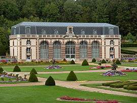
Chateau of the Vaux Orangeraie | ||
| ||
 Saint-Maurice-Saint-Germain | ||
|
Location within Centre-Val de Loire region  Saint-Maurice-Saint-Germain | ||
| Coordinates: 48°29′53″N 1°04′42″E / 48.4981°N 1.0783°ECoordinates: 48°29′53″N 1°04′42″E / 48.4981°N 1.0783°E | ||
| Country | France | |
| Region | Centre-Val de Loire | |
| Department | Eure-et-Loir | |
| Arrondissement | Nogent-le-Rotrou | |
| Canton | La Loupe | |
| Intercommunality | Portes du Perche | |
| Government | ||
| • Mayor (2001–2008) | Charles Bonissol | |
| Area1 | 12.19 km2 (4.71 sq mi) | |
| Population (2008)2 | 401 | |
| • Density | 33/km2 (85/sq mi) | |
| Time zone | CET (UTC+1) | |
| • Summer (DST) | CEST (UTC+2) | |
| INSEE/Postal code | 28354 / 28240 | |
| Elevation |
181–275 m (594–902 ft) (avg. 200 m or 660 ft) | |
|
1 French Land Register data, which excludes lakes, ponds, glaciers > 1 km² (0.386 sq mi or 247 acres) and river estuaries. 2 Population without double counting: residents of multiple communes (e.g., students and military personnel) only counted once. | ||
.svg.png)
Saint-Maurice-Saint-Germain is a commune in the Eure-et-Loir department in northern France.
Population
| Historical population | ||
|---|---|---|
| Year | Pop. | ±% |
| 1962 | 234 | — |
| 1968 | 261 | +11.5% |
| 1975 | 366 | +40.2% |
| 1982 | 378 | +3.3% |
| 1990 | 320 | −15.3% |
| 1999 | 355 | +10.9% |
| 2008 | 401 | +13.0% |
See also
References
| Wikimedia Commons has media related to Saint-Maurice-Saint-Germain. |
This article is issued from Wikipedia - version of the 2/11/2016. The text is available under the Creative Commons Attribution/Share Alike but additional terms may apply for the media files.