Edgar County, Illinois
| Edgar County, Illinois | |
|---|---|
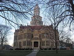 Edgar County Courthouse | |
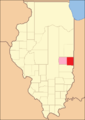
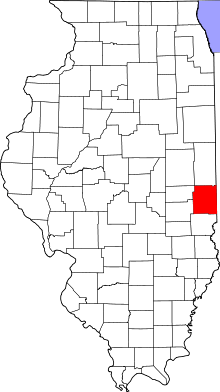 Location in the U.S. state of Illinois | |
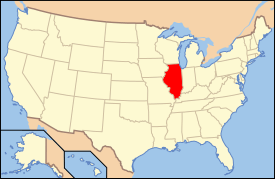 Illinois's location in the U.S. | |
| Founded | January 3, 1823 |
| Named for | John Edgar |
| Seat | Paris |
| Largest city | Paris |
| Area | |
| • Total | 624 sq mi (1,616 km2) |
| • Land | 623 sq mi (1,614 km2) |
| • Water | 0.6 sq mi (2 km2), 0.1% |
| Population | |
| • (2010) | 18,576 |
| • Density | 30/sq mi (12/km²) |
| Congressional district | 15th |
| Time zone | Central: UTC-6/-5 |
| Website |
www |
Edgar County is a county located in the U.S. state of Illinois. As of the 2010 census, the population was 18,576.[1] Its county seat is Paris.[2]
History
Edgar County was formed out of Clark County in 1823 and named for John Edgar,[3] an Irish-born officer in the Royal Navy who resigned rather than fight against the Americans in the Revolutionary War. Edgar moved to Kaskaskia, Illinois in 1784, becoming a miller and merchant in that town.
-
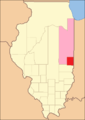
Edgar County was created with its present borders, but had a large tract of unorganized territory temporarily attached to it.[1]
-

Edgar County between 1825 and 1826
-
Edgar County between 1826 and 1830
-

Edgar County in 1830, when the additional territory was incorporated into Coles County
Geography
According to the U.S. Census Bureau, the county has a total area of 624 square miles (1,620 km2), of which 623 square miles (1,610 km2) is land and 0.6 square miles (1.6 km2) (0.1%) is water.[4]
Climate and weather
| Paris, Illinois | ||||||||||||||||||||||||||||||||||||||||||||||||||||||||||||
|---|---|---|---|---|---|---|---|---|---|---|---|---|---|---|---|---|---|---|---|---|---|---|---|---|---|---|---|---|---|---|---|---|---|---|---|---|---|---|---|---|---|---|---|---|---|---|---|---|---|---|---|---|---|---|---|---|---|---|---|---|
| Climate chart (explanation) | ||||||||||||||||||||||||||||||||||||||||||||||||||||||||||||
| ||||||||||||||||||||||||||||||||||||||||||||||||||||||||||||
| ||||||||||||||||||||||||||||||||||||||||||||||||||||||||||||
In recent years, average temperatures in the county seat of Paris have ranged from a low of 16 °F (−9 °C) in January to a high of 86 °F (30 °C) in July, although a record low of −23 °F (−31 °C) was recorded in January 1930 and a record high of 109 °F (43 °C) was recorded in July 1936. Average monthly precipitation ranged from 2.23 inches (57 mm) in January to 4.43 inches (113 mm) in July.[5]
Adjacent counties
- Vermilion County (north)
- Vermillion County, Indiana (northeast)
- Vigo County, Indiana (southeast)
- Clark County (south)
- Coles County (southwest)
- Douglas County (northwest)
- Champaign County (northwest)
Transportation
Major highways
Rail
Three railroad lines run through the county. Two are operated by CSX Transportation and the third by the Eastern Illinois Railroad Company.[6]
Airport
The county contains one public-use airport: Edgar County Airport (PRG), located approximately six miles north of Paris.[7]
Demographics
| Historical population | |||
|---|---|---|---|
| Census | Pop. | %± | |
| 1830 | 4,071 | — | |
| 1840 | 8,225 | 102.0% | |
| 1850 | 10,692 | 30.0% | |
| 1860 | 16,925 | 58.3% | |
| 1870 | 21,450 | 26.7% | |
| 1880 | 25,499 | 18.9% | |
| 1890 | 26,787 | 5.1% | |
| 1900 | 28,273 | 5.5% | |
| 1910 | 27,336 | −3.3% | |
| 1920 | 25,769 | −5.7% | |
| 1930 | 24,966 | −3.1% | |
| 1940 | 24,430 | −2.1% | |
| 1950 | 23,407 | −4.2% | |
| 1960 | 22,550 | −3.7% | |
| 1970 | 21,591 | −4.3% | |
| 1980 | 21,725 | 0.6% | |
| 1990 | 19,595 | −9.8% | |
| 2000 | 19,704 | 0.6% | |
| 2010 | 18,576 | −5.7% | |
| Est. 2015 | 17,664 | [8] | −4.9% |
| U.S. Decennial Census[9] 1790-1960[10] 1900-1990[11] 1990-2000[12] 2010-2013[1] | |||
As of the 2010 United States Census, there were 18,576 people, 7,839 households, and 5,148 families residing in the county.[13] The population density was 29.8 inhabitants per square mile (11.5/km2). There were 8,803 housing units at an average density of 14.1 per square mile (5.4/km2).[4] The racial makeup of the county was 98.3% white, 0.3% black or African American, 0.2% Asian, 0.1% American Indian, 0.3% from other races, and 0.7% from two or more races. Those of Hispanic or Latino origin made up 1.0% of the population.[13] In terms of ancestry, 23.6% were German, 15.3% were Irish, 13.0% were English, and 12.3% were American.[14]
Of the 7,839 households, 28.5% had children under the age of 18 living with them, 50.3% were married couples living together, 10.7% had a female householder with no husband present, 34.3% were non-families, and 29.5% of all households were made up of individuals. The average household size was 2.33 and the average family size was 2.84. The median age was 43.2 years.[13]
The median income for a household in the county was $39,904 and the median income for a family was $51,588. Males had a median income of $38,945 versus $29,951 for females. The per capita income for the county was $22,175. About 9.7% of families and 13.5% of the population were below the poverty line, including 19.2% of those under age 18 and 7.9% of those age 65 or over.[15]
Communities
Cities
Villages
Townships
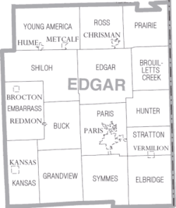
Edgar County is divided into fifteen townships:
See also
References
- United States Census Bureau 2007 TIGER/Line Shapefiles
- United States Board on Geographic Names (GNIS)
- United States National Atlas
- 1 2 "State & County QuickFacts". United States Census Bureau. Retrieved July 4, 2014.
- ↑ "Find a County". National Association of Counties. Retrieved 2011-06-07.
- ↑ Adams, James N. (compiler) (1989), Keller, William E., ed., Illinois Place Names, Springfield: Illinois State Historical Society, p. 580, ISBN 0-912226-24-2
- 1 2 "Population, Housing Units, Area, and Density: 2010 - County". United States Census Bureau. Retrieved 2015-07-11.
- 1 2 "Monthly Averages for Paris, Illinois". The Weather Channel. Retrieved 2011-01-27.
- ↑ Illinois Railroad Map (PDF), retrieved 2007-10-11
- ↑ Public and Private Airports, Edgar County, Illinois
- ↑ "County Totals Dataset: Population, Population Change and Estimated Components of Population Change: April 1, 2010 to July 1, 2015". Retrieved July 2, 2016.
- ↑ "U.S. Decennial Census". United States Census Bureau. Retrieved July 4, 2014.
- ↑ "Historical Census Browser". University of Virginia Library. Retrieved July 4, 2014.
- ↑ "Population of Counties by Decennial Census: 1900 to 1990". United States Census Bureau. Retrieved July 4, 2014.
- ↑ "Census 2000 PHC-T-4. Ranking Tables for Counties: 1990 and 2000" (PDF). United States Census Bureau. Retrieved July 4, 2014.
- 1 2 3 "DP-1 Profile of General Population and Housing Characteristics: 2010 Demographic Profile Data". United States Census Bureau. Retrieved 2015-07-11.
- ↑ "DP02 SELECTED SOCIAL CHARACTERISTICS IN THE UNITED STATES – 2006-2010 American Community Survey 5-Year Estimates". United States Census Bureau. Retrieved 2015-07-11.
- ↑ "DP03 SELECTED ECONOMIC CHARACTERISTICS – 2006-2010 American Community Survey 5-Year Estimates". United States Census Bureau. Retrieved 2015-07-11.
External links
 |
Champaign County | Vermilion County | Vermillion County, Indiana | |
| Coles County | |
|||
| ||||
| | ||||
| Clark County | Vigo County, Indiana |
Municipalities and communities of Edgar County, Illinois, United States | ||
|---|---|---|
| Cities | ||
| Villages | ||
| Townships | ||
| Unincorporated communities | ||
| Footnotes | ‡This populated place also has portions in an adjacent county or counties | |

Coordinates: 39°41′N 87°45′W / 39.68°N 87.75°W