Crawford County, Illinois
| Crawford County, Illinois | |
|---|---|
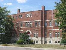 Crawford County Courthouse in Robinson | |
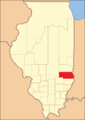
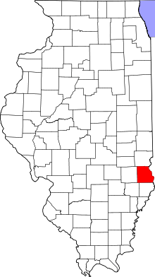 Location in the U.S. state of Illinois | |
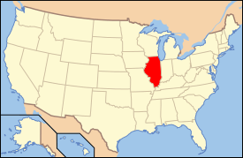 Illinois's location in the U.S. | |
| Founded | 1816 |
| Named for | William H. Crawford |
| Seat | Robinson |
| Largest city | Robinson |
| Area | |
| • Total | 446 sq mi (1,155 km2) |
| • Land | 444 sq mi (1,150 km2) |
| • Water | 2.2 sq mi (6 km2), 0.5% |
| Population | |
| • (2010) | 19,817 |
| • Density | 45/sq mi (17/km²) |
| Congressional district | 15th |
| Time zone | Central: UTC-6/-5 |
| Website |
main |
Crawford County is a county located in the U.S. state of Illinois. As of the 2010 census, the population was 19,817.[1] Its county seat is Robinson.[2]
History
Crawford County was formed in Illinois Territory on December 31, 1816 out of Edwards County. At the time of its formation, it encompassed about one third of the State, but it was reduced to its present borders by 1831 as it spawned new counties. It was named in honor of William H. Crawford,[3] from Georgia, who was serving as Secretary of War and Secretary of the Treasury at the time. Crawford County was home to several battles between the settlers and Indians, and also the location of the only woman ever hanged in Illinois.
-
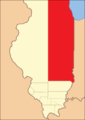
Crawford County at the time of its creation, extending north to Lake Superior.
-

Crawford County between 1819 and 1821
-

Crawford between 1821 and 1824
-
Crawford between 1824 and 1831
-

In 1831, the creation of Jasper and Effingham Counties reduced Crawford to its current size.
In 1818, the town of Palestine was designated as the county seat. After elections in 1843, a new site was chosen, which would become the town of Robinson.[4]
Geography
According to the U.S. Census Bureau, the county has a total area of 446 square miles (1,160 km2), of which 444 square miles (1,150 km2) is land and 2.2 square miles (5.7 km2) (0.5%) is water.[5] Some of the county's eastern border is defined by the Wabash River.
Climate and weather
| Robinson, Illinois | ||||||||||||||||||||||||||||||||||||||||||||||||||||||||||||
|---|---|---|---|---|---|---|---|---|---|---|---|---|---|---|---|---|---|---|---|---|---|---|---|---|---|---|---|---|---|---|---|---|---|---|---|---|---|---|---|---|---|---|---|---|---|---|---|---|---|---|---|---|---|---|---|---|---|---|---|---|
| Climate chart (explanation) | ||||||||||||||||||||||||||||||||||||||||||||||||||||||||||||
| ||||||||||||||||||||||||||||||||||||||||||||||||||||||||||||
| ||||||||||||||||||||||||||||||||||||||||||||||||||||||||||||
In recent years, average temperatures in the county seat of Robinson have ranged from a low of 21 °F (−6 °C) in January to a high of 89 °F (32 °C) in July, although a record low of −23 °F (−31 °C) was recorded in December 1989 and a record high of 114 °F (46 °C) was recorded in July 1954. Average monthly precipitation ranged from 2.45 inches (62 mm) in January to 4.67 inches (119 mm) in May.[6]
Adjacent counties
- Clark County - north
- Sullivan County, Indiana - east
- Knox County, Indiana - southeast
- Lawrence County - south
- Richland County - southwest
- Jasper County - west
Major highways
Demographics

| Historical population | |||
|---|---|---|---|
| Census | Pop. | %± | |
| 1820 | 3,022 | — | |
| 1830 | 3,117 | 3.1% | |
| 1840 | 4,422 | 41.9% | |
| 1850 | 7,135 | 61.4% | |
| 1860 | 11,551 | 61.9% | |
| 1870 | 13,889 | 20.2% | |
| 1880 | 16,197 | 16.6% | |
| 1890 | 17,283 | 6.7% | |
| 1900 | 19,240 | 11.3% | |
| 1910 | 26,281 | 36.6% | |
| 1920 | 22,771 | −13.4% | |
| 1930 | 21,085 | −7.4% | |
| 1940 | 21,294 | 1.0% | |
| 1950 | 21,137 | −0.7% | |
| 1960 | 20,751 | −1.8% | |
| 1970 | 19,824 | −4.5% | |
| 1980 | 20,818 | 5.0% | |
| 1990 | 19,464 | −6.5% | |
| 2000 | 20,452 | 5.1% | |
| 2010 | 19,817 | −3.1% | |
| Est. 2015 | 19,414 | [7] | −2.0% |
| U.S. Decennial Census[8] 1790-1960[9] 1900-1990[10] 1990-2000[11] 2010-2013[1] | |||
As of the 2010 United States Census, there were 19,817 people, 7,763 households, and 5,154 families residing in the county.[12] The population density was 44.7 inhabitants per square mile (17.3/km2). There were 8,661 housing units at an average density of 19.5 per square mile (7.5/km2).[5] The racial makeup of the county was 92.8% white, 4.7% black or African American, 0.5% Asian, 0.2% American Indian, 0.8% from other races, and 0.9% from two or more races. Those of Hispanic or Latino origin made up 1.8% of the population.[12] In terms of ancestry, 25.0% were German, 14.4% were American, 12.4% were Irish, and 9.9% were English.[13]
Of the 7,763 households, 28.5% had children under the age of 18 living with them, 52.6% were married couples living together, 9.4% had a female householder with no husband present, 33.6% were non-families, and 29.1% of all households were made up of individuals. The average household size was 2.36 and the average family size was 2.88. The median age was 41.7 years.[12]
The median income for a household in the county was $41,434 and the median income for a family was $51,218. Males had a median income of $40,050 versus $30,870 for females. The per capita income for the county was $21,545. About 11.1% of families and 16.9% of the population were below the poverty line, including 27.0% of those under age 18 and 8.2% of those age 65 or over.[14]
Communities
Cities
Villages
Townships
Crawford County is divided into ten townships:
See also
Sources
- Perrin, William Henry, ed.. History of Crawford and Clark Counties, Illinois Chicago, Illinois. O. L. Baskin & Co. (1883).
References
- Specific
- 1 2 "State & County QuickFacts". United States Census Bureau. Retrieved July 4, 2014.
- ↑ "Find a County". National Association of Counties. Archived from the original on 2011-05-31. Retrieved 2011-06-07.
- ↑ Gannett, Henry (1905). The Origin of Certain Place Names in the United States. Govt. Print. Off. p. 95.
- ↑ Perrin, p. 42.
- 1 2 "Population, Housing Units, Area, and Density: 2010 - County". United States Census Bureau. Retrieved 2015-07-11.
- 1 2 "Monthly Averages for Robinson, Illinois". The Weather Channel. Retrieved 2011-01-27.
- ↑ "County Totals Dataset: Population, Population Change and Estimated Components of Population Change: April 1, 2010 to July 1, 2015". Retrieved July 2, 2016.
- ↑ "U.S. Decennial Census". United States Census Bureau. Archived from the original on May 11, 2015. Retrieved July 4, 2014.
- ↑ "Historical Census Browser". University of Virginia Library. Retrieved July 4, 2014.
- ↑ "Population of Counties by Decennial Census: 1900 to 1990". United States Census Bureau. Retrieved July 4, 2014.
- ↑ "Census 2000 PHC-T-4. Ranking Tables for Counties: 1990 and 2000" (PDF). United States Census Bureau. Retrieved July 4, 2014.
- 1 2 3 "DP-1 Profile of General Population and Housing Characteristics: 2010 Demographic Profile Data". United States Census Bureau. Retrieved 2015-07-11.
- ↑ "DP02 SELECTED SOCIAL CHARACTERISTICS IN THE UNITED STATES – 2006-2010 American Community Survey 5-Year Estimates". United States Census Bureau. Retrieved 2015-07-11.
- ↑ "DP03 SELECTED ECONOMIC CHARACTERISTICS – 2006-2010 American Community Survey 5-Year Estimates". United States Census Bureau. Retrieved 2015-07-11.
- General
- United States Census Bureau 2007 TIGER/Line Shapefiles
- United States Board on Geographic Names (GNIS)
- United States National Atlas
External links
 |
Clark County | | ||
| Jasper County | |
Sullivan County, Indiana | ||
| ||||
| | ||||
| Richland County | Lawrence County | Knox County, Indiana |
Municipalities and communities of Crawford County, Illinois, United States | ||
|---|---|---|
| City | ||
| Town | ||
| Villages | ||
| Townships | ||
| CDPs | ||
| Other unincorporated communities | ||
| Ghost town | ||
| Footnotes | ‡This populated place also has portions in an adjacent county or counties | |

Coordinates: 39°00′N 87°46′W / 39.00°N 87.76°W