Belleville, Illinois
| Belleville, Illinois | |
| City | |
 Belleville welcome sign | |
| Country | United States |
|---|---|
| State | Illinois |
| County | St. Clair |
| Township | Belleville |
| Elevation | 515 ft (157 m) |
| Coordinates | 38°31′18″N 89°59′43″W / 38.52167°N 89.99528°WCoordinates: 38°31′18″N 89°59′43″W / 38.52167°N 89.99528°W |
| Area | 23.01 sq mi (60 km2) |
| - land | 22.74 sq mi (59 km2) |
| - water | 0.27 sq mi (1 km2) |
| Population | 43,765 (2012) |
| Density | 2,196.4/sq mi (848/km2) |
| Founded | 1814 |
| Mayor | Mark W. Eckert |
| Timezone | CST (UTC-6) |
| - summer (DST) | CDT (UTC-5) |
| Postal code | 62220-62223, 62225, 62226 |
| Area code | 618 |
 Location in St. Clair County and the state of Illinois.
| |
.svg.png) Location of Illinois in the United States
| |
| Wikimedia Commons: Belleville, Illinois | |
| Website: belleville | |
Belleville (French: Belle ville, meaning "Beautiful city") is a city in St. Clair County, Illinois, United States, co-extensive with Belleville Township. The population was 42,034 according to the Census Bureau's 2015 estimates.[1] It is the eighth-most populated city outside the Chicago Metropolitan Area and the most populated city south of Springfield in the state of Illinois. It is the county seat of St. Clair County,[2] and the seat of the Roman Catholic Diocese of Belleville and the National Shrine of Our Lady of the Snows. Belleville is the most populated city in the Metro-East region of the St. Louis Metropolitan Area and in Southern Illinois. Due to its proximity to Scott Air Force Base, the population receives a boost from military and federal civilian personnel, defense contractors, and military retirees.
History

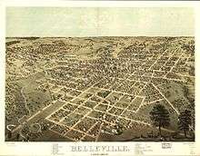
The city of Belleville was named by George Blair in 1814. Blair donated an acre of his land for the Town Square and an additional 25 acres (100,000 m2) adjoining the square for the new county seat, causing the county seat to be transferred from the village of Cahokia. Belleville was incorporated as a village in 1819, and became a city in 1850. It is said that Blair named the city Belleville (French for "beautiful city") because he believed that a French name would attract new residents. Since major immigration in the mid-19th century occurred following revolutions in Germany, most of the population is of German heritage.
Many of the educated people fled their homeland after the failure of the German Revolution in 1848. Belleville was the center of the first important German settlement in Illinois. By 1870, an estimated 90% of the city's population was either German born or of German descent.[3]
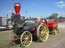
After the Civil War, Belleville became a manufacturing center producing nails, printing presses, gray iron castings, agricultural equipment, and stoves. Belleville became known as "The Stove Capital of the World." The first brewery in Illinois was established in Belleville and in 1868, Gustav Goelitz founded the candy company that is known today as "Jelly Belly."[3]
An immense deposit (400,000 acres (1,600 km2)) of bituminous coal was found in St. Clair County. By 1874, some farmers had become coal miners. One hundred shaft mines were in operation in and around Belleville. The coal brought the steam railroad to town, which allowed for the transport of many tons of coal to be shipped daily from Belleville to St. Louis. Later, Belleville would have the first electric trolley in the state.[3]
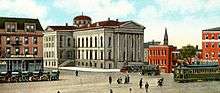
The first style of homes in Belleville was simple brick cottages, known locally as "German street houses" or "row houses." However, there is a great variety of architectural style with American Foursquare, French Second Empire, Greek Revival, Gothic Revival, Italianate, Queen Anne, and Victorian.[4] The Belleville Historic District, which was listed on the National Register of Historic Places in 1976, comprises 73 contributing properties.[5] The "Old Belleville Historic District," was formed in 1974 and is the city’s first historic district.[4] The city also had two more historic districts: "Hexenbukel" (est. in 1991) and "Oakland" (est. in 1995).[6]
Belleville’s early German immigrants were scholarly, with most of them having graduated from German universities. They were nicknamed “Latin Farmers” because of this. After 1836 Gustav Koerner contributed to establish the city’s public library. The Belleville Public Library is the state’s oldest, predating the Illinois State Library by three years. The German settlers also founded choral and dramatic groups as well as literary societies. Belleville was also home to one of the first kindergartens in the country.[3][4]
The National Civic League recognized Belleville as one of the ten 2011 recipients of the All-America City Award.
Geography
Belleville is located at 38°31′18″N 89°59′43″W / 38.52167°N 89.99528°W (38.521567, -89.995208).[7]
According to the 2010 census, Belleville has a total area of 23.009 square miles (59.59 km2), of which 22.74 square miles (58.90 km2) (or 98.83%) is land and 0.269 square miles (0.70 km2) (or 1.17%) is water.[8] Richland Creek flows through much of Belleville.
Culture and contemporary life
Entertainment and performing arts
The Belleville Philharmonic Society was formed in 1866, making it the second oldest philharmonic orchestra in the country.[9] With the increase in black population and migrants from the South, musicians developed who played blues and jazz; later rock clubs were added to the scene.
Jay Farrar (now of Son Volt), Mike Heidorn, and Jeff Tweedy (now of Wilco) of the now-defunct alt country group Uncle Tupelo are from Belleville. Another major musician was Neal Doughty, keyboardist for 1970s rock band REO Speedwagon.
National Register of Historic Places
Annual events
Belleville holds several celebrations throughout the year:
- St Patrick's Day Parade (March 17)
- Ale Fest (April)
- Art on the Square. This festival was recently named the "#1 Art Fair in the Nation" by the Art Fair Source Book.[10]
- Ainad Shriner's Circus Parade (1st Friday in June)
- Wine Dine and Jazz (June)
- Labor Day Parade (September)
- Oktoberfest (September)
- Chili Cookoff (October)
- Santa Claus Parade (November)
- Gingerbread Walk (December)
- Tour de Belleville (July)[11]
- Memorial Day Parade
Sports
- Rowdies Rugby Football Club — the only rugby football club in the Belleville area.
- Lindenwood Stadium is a college football stadium with alternating red and gray stripes. It has been called "The nation’s most original (hideous) football field."[12]
Demographics
| Historical population | |||
|---|---|---|---|
| Census | Pop. | %± | |
| 1850 | 2,941 | — | |
| 1860 | 7,520 | 155.7% | |
| 1870 | 8,146 | 8.3% | |
| 1880 | 10,683 | 31.1% | |
| 1890 | 15,361 | 43.8% | |
| 1900 | 17,484 | 13.8% | |
| 1910 | 21,122 | 20.8% | |
| 1920 | 24,823 | 17.5% | |
| 1930 | 28,425 | 14.5% | |
| 1940 | 28,405 | −0.1% | |
| 1950 | 32,721 | 15.2% | |
| 1960 | 37,264 | 13.9% | |
| 1970 | 41,223 | 10.6% | |
| 1980 | 41,580 | 0.9% | |
| 1990 | 42,785 | 2.9% | |
| 2000 | 41,410 | −3.2% | |
| 2010 | 44,478 | 7.4% | |
| Est. 2015 | 42,034 | [13] | −5.5% |
| U.S. Decennial Census[14] 2012 Estimate[15] | |||
As of the census[16] of 2000, there were 41,410 people, 17,603 households, and 10,420 families residing in the city. The population density was 2,196.4 people per square mile (848.2/km²). There were 19,142 housing units at an average density of 1,015.3 per square mile (392.1/km²). The racial makeup of the city was 81.51% White, 15.51% African American, 0.26% Native American, 0.81% Asian, 0.07% Pacific Islander, 0.41% from other races, and 1.43% from two or more races. Hispanic or Latino of any race were 1.63% of the population.
There were 17,603 households out of which 28.4% had children under the age of 18 living with them, 42.0% were married couples living together, 13.5% had a female householder with no husband present, and 40.8% were non-families. 35.1% of all households were made up of individuals and 14.0% had someone living alone who was 65 years of age or older. The average household size was 2.27 and the average family size was 2.95.
In the city the population was spread out with 23.4% under the age of 18, 9.0% from 18 to 24, 30.3% from 25 to 44, 20.1% from 45 to 64, and 17.2% who were 65 years of age or older. The median age was 37 years. For every 100 females there were 88.9 males. For every 100 females age 18 and over, there were 85.0 males.
The median income for a household in the city was $35,979, and the median income for a family was $46,426. Males had a median income of $33,361 versus $25,375 for females. The per capita income for the city was $18,990. About 9.3% of families and 11.7% of the population were below the poverty line, including 16.2% of those under age 18 and 9.3% of those age 65 or over.
Notable people
Education
Higher Education
- Saint Louis University Belleville Campus
- Lindenwood University-Belleville
- Southwestern Illinois College
Four high schools — two public (Belleville Township HS East, Belleville Township HS West), and two private (Althoff Catholic HS, Governor French Academy).
Belleville is also home to a relatively large grade school district. Belleville District 118 has 9 elementary schools, (Roosevelt, Abraham Lincoln, Douglas, Franklin, Jefferson, Union, Westhaven, Henry Raab, and Washington) and 2 junior high schools (Central Junior High and West Junior High). Belle Valley School District 119 is also available for public school. Harmony School District 175 includes Ellis Elementary and Emge Jr. High. Signal Hill School is the only school in district 181. Whiteside Elementary School and Whiteside Middle School make up district 115. Parochial grade schools include St. Peter's Cathedral, St. Augustine of Canterbury Church, St. Teresa, Blessed Sacrament, Our Lady Queen of Peace, and Zion Lutheran School.[17]
Media
The Belleville News-Democrat, is the city's daily newspaper. The News-Democrat is part of the McClatchy chain and covers the Metro East region and Southwestern Illinois. The city is also served by the St. Louis Post-Dispatch, the area's major metropolitan daily. Belleville receives the signals of most radio and TV stations based in St. Louis.
Transportation
Belleville has three St. Louis MetroLink stations connecting it to St. Louis and the network via light rail: Memorial Hospital, Belleville, and College.
Illinois State Highways 15, 159, 177, 13 and 161 all pass through Belleville. Belleville is also adjacent to Interstate highways 64 and 255. I-64 is an east-west highway extending from Wentzville, Missouri to Virginia Beach, Virginia and is the major route from Belleville to downtown St. Louis. I-255 is part of a system of expressways that together form a loop around St. Louis.
Belleville has a bicycle trail that runs through the city from Southside Park to Southwestern Illinois College; it is mainly used for recreational purposes
Belleville's area airports are Scott Air Force Base and MidAmerica St. Louis Airport, and the nearest major airport with regular scheduled commercial passenger service is Lambert St. Louis International Airport.
Sister city
Belleville is a sister city to Paderborn, Germany.[18]
References
- ↑ QuickFacts: Belleville city, Illinois, United States Census Bureau, n.d. Accessed 2016-06-22.
- ↑ "Find a County". National Association of Counties. Archived from the original on 2012-07-12. Retrieved 2011-06-07.
- 1 2 3 4 "Labor and Industry Museum", Labor and Industry Museum: Belleville History, accessed 1 December 2010]
- 1 2 3 "Village Profile", Village Profile: History and Culture, 1997, accessed 1 December 2010]
- ↑ National Park Service (2010-07-09). "National Register Information System". National Register of Historic Places. National Park Service.
- ↑ "Labor and Industry Museum", Labor and Industry Museum: Other Historic Resources, accessed 1 December 2010
- ↑ "US Gazetteer files: 2010, 2000, and 1990". United States Census Bureau. 2011-02-12. Retrieved 2011-04-23.
- ↑ "G001 - Geographic Identifiers - 2010 Census Summary File 1". United States Census Bureau. Retrieved 2015-12-25.
- ↑ Belleville Philharmonic Society Symphony Orchestra Archived November 11, 2007, at the Wayback Machine.
- ↑ "Notable Art Fairs", Art Fair Source Book
- ↑ Kirsch, Robyn. "Are you ready to ride your bike? Tour de Belleville rolls through town Friday". Belleville News Democrat. Retrieved 23 July 2012.
- ↑ Watson, Graham (July 11, 2012). "NAIA school unveils the nation's most original football field". Yahoo Sports. Retrieved September 7, 2012.
- ↑ "Annual Estimates of the Resident Population for Incorporated Places: April 1, 2010 to July 1, 2015". Retrieved July 2, 2016.
- ↑ "U.S. Decennial Census". Census.gov. Archived from the original on May 11, 2015. Retrieved June 2, 2014.
- ↑ "Annual Estimates of the Resident Population: April 1, 2010 to July 1, 2013". Census.gov. Retrieved June 2, 2014.
- ↑ "American FactFinder". United States Census Bureau. Archived from the original on 2013-09-11. Retrieved 2008-01-31.
- ↑ "St. Clair County Regional Office of Education" Archived February 21, 2009, at the Wayback Machine., St. Clair County Regional Office of Education, 12/2010, accessed 15 December 2010
- ↑ Belleville Sister Cities, Inc Archived March 24, 2008, at the Wayback Machine. is the organization which fosters the relationship between the two cities.
External links
| Wikimedia Commons has media related to Belleville, Illinois. |
| Wikisource has the text of a 1911 Encyclopædia Britannica article about Belleville, Illinois. |
- Official website
- The Belleville News Democrat Online
- Belleville Public Library
- The Belleville Historical Society
- "Belleville Bicentennial Celebration". City of Belleville, Illinois. 2013.
| Counties | 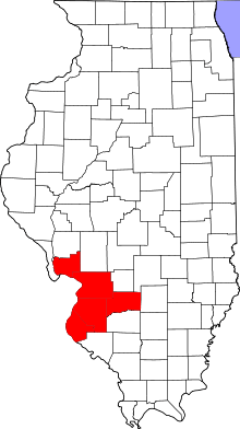 | |
|---|---|---|
| Major Cities (25,000+) | ||
| Cities (5,000-25,000) | ||
| Villages and Towns (1,000-5,000) |
| |
| Interstates in the Metro-East | ||
| Airports/Military Bases | ||
| List of Colleges in the Metro-East | ||
| Sports teams based in the Metro East |
| |
| Topics |  | |
|---|---|---|
| Central city | ||
| Largest cities (over 50,000 in 2010) | ||
| Medium-sized cities (over 20,000 in 2010) | ||
| Largest towns and villages (over 10,000 in 2010) |
| |
| Missouri Counties | ||
| Illinois Counties | ||
| Subregions | ||
Municipalities and communities of St. Clair County, Illinois, United States | ||
|---|---|---|
| Cities | ||
| Villages | ||
| Townships | ||
| CDPs | ||
| Other unincorporated communities | ||
| Footnotes | ‡This populated place also has portions in an adjacent county or counties | |
| Counties | 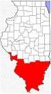 | |
|---|---|---|
| Mid-sized cities (25,000+) | ||
| Small Cities (10,000-25,000) | ||
| Small Cities (5,000-10,000) | ||
| Interstates | ||
| Airports/Military bases |
| |
| Universities | ||
| Colleges | ||
| Sports teams based in the Southern Illinois | ||