Woodland Park, Colorado
| City of Woodland Park, Colorado | |
|---|---|
| City | |
|
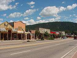
A section of historic downtown Woodland Park. | |
| Nickname(s): The city above the clouds | |
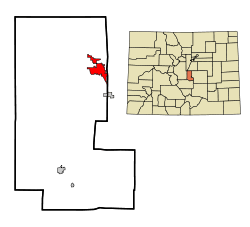 Location in Teller County and the state of Colorado | |
| Coordinates: 38°59′54″N 105°3′23″W / 38.99833°N 105.05639°WCoordinates: 38°59′54″N 105°3′23″W / 38.99833°N 105.05639°W | |
| Country |
|
| State |
|
| County[1] | Teller County |
| Incorporated | June 6, 1891[2] |
| Government | |
| • Type | Home Rule Municipality[1] |
| • Mayor | Neil Levy[3] |
| Area | |
| • Total | 5.7 sq mi (14.7 km2) |
| • Land | 5.7 sq mi (14.7 km2) |
| • Water | 0 sq mi (0 km2) |
| Elevation | 8,465 ft (2,580 m) |
| Population (2000) | |
| • Total | 6,515 |
| • Density | 1,143/sq mi (443.2/km2) |
| Time zone | MST (UTC-7) |
| • Summer (DST) | MDT (UTC-6) |
| ZIP code[4] | 80863, 80866 (PO Box) |
| Area code(s) | 719 |
| FIPS code | 08-86090 |
| GNIS feature ID | 0204768 |
| Website | www.citywoodlandpark.org |
The City of Woodland Park is a Home Rule Municipality that is the most populous city in Teller County, Colorado, United States and is immediately west of El Paso County and the unincorporated community of Crystola. Many residents in this bedroom community, which is surrounded by the one-million acre (4,000 km²) Pike National Forest, make the 17-mile (27 km) commute to Colorado Springs. Ute Pass lies 12 miles (19 km) to the west of Woodland Park on US 24. The population was 6,515 at the 2000 census. Nearby Douglas County is about a fifteen-minute drive from the city.
A post office called Woodland Park has been in operation since 1890.[5] The community was named for the abundance of trees near the original town site.[6]
Geography
Woodland Park is located at the eastern intersection of U.S. Highway 24 and State Highway 67. (The highways overlap west to Divide.)
According to the United States Census Bureau, the city has a total area of 5.7 square miles (15 km2), all of it land.
Demographics
| Historical population | |||
|---|---|---|---|
| Census | Pop. | %± | |
| 1900 | 269 | — | |
| 1910 | 163 | −39.4% | |
| 1920 | 125 | −23.3% | |
| 1930 | 194 | 55.2% | |
| 1940 | 372 | 91.8% | |
| 1950 | 391 | 5.1% | |
| 1960 | 666 | 70.3% | |
| 1970 | 1,022 | 53.5% | |
| 1980 | 2,634 | 157.7% | |
| 1990 | 4,610 | 75.0% | |
| 2000 | 6,515 | 41.3% | |
| 2010 | 7,200 | 10.5% | |
| Est. 2015 | 7,222 | [7] | 0.3% |
As of the census[9] of 2000, there were 6,515 people, 2,476 households, and 1,884 families residing in the city. The population density was 1,151.0 people per square mile (444.4/km²). There were 2,642 housing units at an average density of 466.8 per square mile (180.2/km²). The racial makeup of the city was 94.89% White, 0.52% African American, 0.72% Native American, 0.87% Asian, 0.81% from other races, and 2.18% from two or more races. Hispanic or Latino of any race were 3.45% of the population.
There were 2,476 households out of which 39.9% had children under the age of 18 living with them, 65.3% were married couples living together, 7.7% had a female householder with no husband present, and 23.9% were non-families. 19.1% of all households were made up of individuals and 4.3% had someone living alone who was 65 years of age or older. The average household size was 2.63 and the average family size was 3.03.
In the city the population was spread out with 28.5% under the age of 18, 5.8% from 18 to 24, 32.9% from 25 to 44, 26.3% from 45 to 64, and 6.5% who were 65 years of age or older. The median age was 38 years. For every 100 females there were 100.4 males. For every 100 females age 18 and over, there were 97.0 males.
The median income for a household in the city was $52,279, and the median income for a family was $59,583. Males had a median income of $36,157 versus $27,459 for females. The per capita income for the city was $22,780. About 1.8% of families and 3.7% of the population were below the poverty line, including 4.9% of those under age 18 and 3.7% of those age 65 or over.
Students are served by Woodland Park School District RE-2.
Gallery
.jpg) Woodland Park, 1887
Woodland Park, 1887 Library in Downtown Woodland Park
 View of Pikes Peak, from Woodland Park
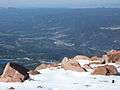 Woodland Park as viewed from the summit of Pikes Peak
Arts and culture
A number of full-time musicians reside in Woodland Park and the surrounding areas, and arts festivals have become more frequent in recent years, often held at the Ute Pass Cultural Center. Woodland Park is also the site of the Rocky Mountain Dinosaur Resource Center, a museum devoted to dinosaurs and fossils.
Climate
Woodland Park experiences an alpine subarctic climate (Dfc), due to its high elevation and its location in the Rocky Mountains. Summers are warm, but much milder than summers at lower elevations, such as in Colorado Springs, Denver, or the plains to the east. Nights are cool, even chilly in summer.
| Climate data for Woodland Park, Colorado | |||||||||||||
|---|---|---|---|---|---|---|---|---|---|---|---|---|---|
| Month | Jan | Feb | Mar | Apr | May | Jun | Jul | Aug | Sep | Oct | Nov | Dec | Year |
| Average high °F (°C) | 34.7 (1.5) |
36.7 (2.6) |
41.4 (5.2) |
49.3 (9.6) |
58.5 (14.7) |
69.3 (20.7) |
74.5 (23.6) |
71.8 (22.1) |
65.3 (18.5) |
55.8 (13.2) |
42.8 (6) |
35.6 (2) |
52.98 (11.64) |
| Daily mean °F (°C) | 19.6 (−6.9) |
21.6 (−5.8) |
27.0 (−2.8) |
35.4 (1.9) |
44.2 (6.8) |
53.4 (11.9) |
58.6 (14.8) |
56.5 (13.6) |
49.5 (9.7) |
40.1 (4.5) |
28.4 (−2) |
21.0 (−6.1) |
37.94 (3.3) |
| Average low °F (°C) | 4.5 (−15.3) |
6.4 (−14.2) |
12.6 (−10.8) |
21.6 (−5.8) |
30.0 (−1.1) |
37.6 (3.1) |
43.0 (6.1) |
41.4 (5.2) |
33.6 (0.9) |
24.4 (−4.2) |
14.0 (−10) |
6.6 (−14.1) |
22.98 (−5.02) |
| Average precipitation inches (mm) | 0.47 (12) |
0.67 (17) |
1.42 (36) |
1.77 (45) |
2.24 (57) |
2.13 (54) |
3.27 (83) |
3.19 (81) |
1.57 (40) |
1.18 (30) |
0.79 (20) |
0.71 (18) |
19.41 (493) |
| Source: [10] | |||||||||||||
Notable people
- Robert L. Stewart (Brigadier General, USA, Ret.) - former NASA astronaut[11]
- Clint Vahsholtz - ARCA driver
See also
- Outline of Colorado
- State of Colorado
- Manitou Park Recreation Area, Colorado
- Woodland Park High School
References
- 1 2 "Active Colorado Municipalities". State of Colorado, Department of Local Affairs. Retrieved 2007-09-01.
- ↑ "Colorado Municipal Incorporations". State of Colorado, Department of Personnel & Administration, Colorado State Archives. 2004-12-01. Retrieved 2007-09-02.
- ↑ "Woodland Park City Council". City of Woodland Park. Retrieved 2007-08-14.
- ↑ "ZIP Code Lookup" (JavaScript/HTML). United States Postal Service. Retrieved 2008-01-10.
- ↑ "Post offices". Jim Forte Postal History. Retrieved 11 July 2016.
- ↑ Dawson, John Frank. Place names in Colorado: why 700 communities were so named, 150 of Spanish or Indian origin. Denver, CO: The J. Frank Dawson Publishing Co. p. 52.
- ↑ "Annual Estimates of the Resident Population for Incorporated Places: April 1, 2010 to July 1, 2015". Retrieved July 2, 2016.
- ↑ "Census of Population and Housing". Census.gov. Retrieved June 4, 2015.
- ↑ "American FactFinder". United States Census Bureau. Retrieved 2008-01-31.
- ↑ "Climate: Woodland Park - Climate graph, Temperature graph, Climate table - Climate-Data.org". En.climate-data.org. Retrieved 2016-05-23.
- ↑ Roper, Peter. "Ex-astronaut says NASA should be focusing on Mars". The Pueblo Chieftain Online. Archived from the original on 2007-12-05. Retrieved 2007-12-11.
External links
| Wikimedia Commons has media related to Woodland Park, Colorado. |
- City of Woodland Park website
- The Greater Woodland Park Chamber of Commerce
- Woodland Park Relocation Guide
- Teller County (County Information & Links)
- Live webcam views of Woodland Park & Pikes Peak
Municipalities and communities of Teller County, Colorado, United States | ||
|---|---|---|
| Cities | 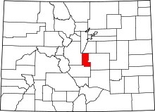 | |
| Town | ||
| CDPs | ||
| Unincorporated community | ||
| Ghost towns | ||
| Footnotes | ‡This populated place also has portions in an adjacent county or counties | |
