Frontenac, Missouri
| Frontenac, Missouri | |
|---|---|
| City | |
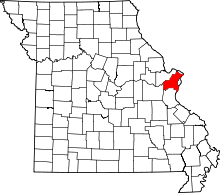
 Location of Frontenac, Missouri | |
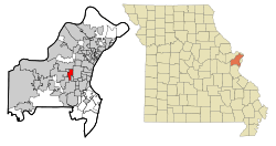
 U.S. Census reference map. | |
| Coordinates: 38°38′2″N 90°25′4″W / 38.63389°N 90.41778°WCoordinates: 38°38′2″N 90°25′4″W / 38.63389°N 90.41778°W | |
| Country | United States |
| State | Missouri |
| County | St. Louis |
| Government | |
| • Mayor | Keith Krieg |
| Area[1] | |
| • Total | 2.88 sq mi (7.46 km2) |
| • Land | 2.88 sq mi (7.46 km2) |
| • Water | 0 sq mi (0 km2) |
| Elevation | 577 ft (176 m) |
| Population (2010)[2] | |
| • Total | 3,482 |
| • Estimate (2012[3]) | 3,508 |
| • Density | 1,209.0/sq mi (466.8/km2) |
| Time zone | Central (CST) (UTC-6) |
| • Summer (DST) | CDT (UTC-5) |
| ZIP code | 63131 |
| Area code(s) | 314 |
| FIPS code | 29-26110[4] |
| GNIS feature ID | 0756086[5] |
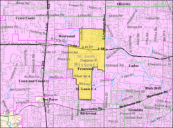
Frontenac is a wealthy inner-ring suburb of St. Louis, located in St. Louis County, Missouri, United States. The signature landmark is Plaza Frontenac, a high-end mall featuring many prominent retailers such as Saks Fifth Avenue, Neiman Marcus, and Tiffany & Co., among others. The population was 3,482 at the 2010 census.[6]
The community name is inspired by the Château Frontenac of Quebec City. Benjamin and Lora Wood, who laid out the community's core called Frontenac Estates, that consisted of 26 two-acre estates, had made frequent trips to Quebec. The community was incorporated as 217 acres (88 ha) in 1947 and annexed another 967 acres (391 ha) in 1948. The community still consists mostly of houses on one-acre lots. French architecture is encouraged in design.[7][8]
Geography
Frontenac is located at 38°38′2″N 90°25′4″W / 38.63389°N 90.41778°W (38.633752, -90.417901).[9]
According to the United States Census Bureau, the city has a total area of 2.88 square miles (7.46 km2), all of it land.[1]
Demographics
| Historical population | |||
|---|---|---|---|
| Census | Pop. | %± | |
| 1950 | 1,099 | — | |
| 1960 | 3,089 | 181.1% | |
| 1970 | 3,920 | 26.9% | |
| 1980 | 3,654 | −6.8% | |
| 1990 | 3,374 | −7.7% | |
| 2000 | 3,483 | 3.2% | |
| 2010 | 3,482 | 0.0% | |
| Est. 2015 | 3,574 | [10] | 2.6% |
2010 census
As of the census[2] of 2010, there were 3,482 people, 1,267 households, and 1,036 families residing in the city. The population density was 1,209.0 inhabitants per square mile (466.8/km2). There were 1,357 housing units at an average density of 471.2 per square mile (181.9/km2). The racial makeup of the city was 90.1% White, 2.6% African American, 0.1% Native American, 5.6% Asian, 0.3% from other races, and 1.2% from two or more races. Hispanic or Latino of any race were 1.5% of the population.
There were 1,267 households of which 34.6% had children under the age of 18 living with them, 73.3% were married couples living together, 5.4% had a female householder with no husband present, 3.0% had a male householder with no wife present, and 18.2% were non-families. 16.1% of all households were made up of individuals and 8.6% had someone living alone who was 65 years of age or older. The average household size was 2.70 and the average family size was 3.03.
The median age in the city was 49.2 years. 24.9% of residents were under the age of 18; 5.3% were between the ages of 18 and 24; 13.1% were from 25 to 44; 35.5% were from 45 to 64; and 21.3% were 65 years of age or older. The gender makeup of the city was 47.6% male and 52.4% female.
2000 census
As of the census[4] of 2000, there were 3,483 people, 1,297 households, and 1,050 families residing in the city. The population density was 1,221.3 people per square mile (471.9/km²). There were 1,360 housing units at an average density of 476.9 per square mile (184.2/km²). The racial makeup of the city was 95.12% White, 0.80% African American, 0.09% Native American, 2.78% Asian, 0.14% from other races, and 1.06% from two or more races. Hispanic or Latino of any race were 0.95% of the population.
There were 1,297 households out of which 32.8% had children under the age of 18 living with them, 74.9% were married couples living together, 4.2% had a female householder with no husband present, and 19.0% were non-families. 17.2% of all households were made up of individuals and 9.4% had someone living alone who was 65 years of age or older. The average household size was 2.67 and the average family size was 3.00.
In the city the population was spread out with 26.3% under the age of 18, 3.4% from 18 to 24, 18.1% from 25 to 44, 31.0% from 45 to 64, and 21.2% who were 65 years of age or older. The median age was 46 years. For every 100 females there were 92.2 males. For every 100 females age 18 and over, there were 92.0 males.
The median income for a household in the city was $119,508, and the median income for a family was $136,972. Males had a median income of $100,000 versus $47,344 for females. The per capita income for the city was $64,532. About 0.8% of families and 1.2% of the population were below the poverty line, including 0.6% of those under age 18 and 1.0% of those age 65 or over.
Education
- Ladue School District, a public school district serving Frontenac.
- St. Joseph's Academy, an all-girls high school.
- Chaminade College Preparatory School, an all-boys middle and high school.
- Villa Duchesne and Oak Hill School, a Sacred Heart School for boys and girls grades JK-6 and young women grades 7-12.
Kirkwood School District, a public school district serving a portion of south Frontenac.
See also
References
- 1 2 "US Gazetteer files 2010". United States Census Bureau. Retrieved 2012-07-08.
- 1 2 "American FactFinder". United States Census Bureau. Retrieved 2012-07-08.
- ↑ "Population Estimates". United States Census Bureau. Retrieved 2013-05-30.
- 1 2 "American FactFinder". United States Census Bureau. Retrieved 2008-01-31.
- ↑ "US Board on Geographic Names". United States Geological Survey. 2007-10-25. Retrieved 2008-01-31.
- ↑ "Race, Hispanic or Latino, Age, and Housing Occupancy: 2010 Census Redistricting Data (Public Law 94-171) Summary File (QT-PL), Frontenac city, Missouri". U.S. Census Bureau, American FactFinder 2. Retrieved October 21, 2011.
- ↑ http://www.cityoffrontenac.org/index.php?id=30
- ↑ http://www.cityoffrontenac.org/assets/files/boa/Strategic%20Plan%20-%20Branding%20Document.pdf
- ↑ "US Gazetteer files: 2010, 2000, and 1990". United States Census Bureau. 2011-02-12. Retrieved 2011-04-23.
- ↑ "Annual Estimates of the Resident Population for Incorporated Places: April 1, 2010 to July 1, 2015". Retrieved July 2, 2016.
- ↑ "Census of Population and Housing". Census.gov. Retrieved June 4, 2015.