Clayton, Missouri
| Clayton | |
|---|---|
| City | |
| Clayton, Missouri | |
| Nickname(s): Claymo | |
 Location in Missouri | |
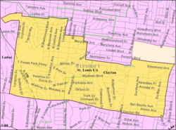 U.S. Census Map | |
| Coordinates: 38°38′43″N 90°19′55″W / 38.64528°N 90.33194°WCoordinates: 38°38′43″N 90°19′55″W / 38.64528°N 90.33194°W | |
| Country | United States |
| State | Missouri |
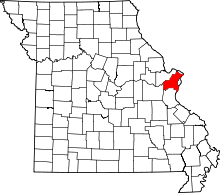
| County | St. Louis |
| Settled | 1877 |
| Incorporated | 1913 |
| Government | |
| • Type | Mayor-council city |
| • Mayor | Harold Sanger |
| Area[1] | |
| • Total | 2.48 sq mi (6.42 km2) |
| • Land | 2.48 sq mi (6.42 km2) |
| • Water | 0 sq mi (0 km2) |
| Elevation | 568 ft (173 m) |
| Population (2010)[2] | |
| • Total | 15,939 |
| • Estimate (2013)[3] | 15,884 |
| • Density | 6,427.0/sq mi (2,481.5/km2) |
| Time zone | Central (UTC-6) |
| • Summer (DST) | Central (UTC-5) |
| ZIP code | 63105 |
| Area code(s) | 314 |
| FIPS code | 29-14572[4] |
| GNIS feature ID | 0755896[5] |
| Website | City of Clayton |
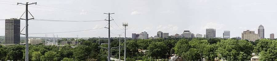
Clayton is a city in and the county seat of St. Louis County, Missouri, United States,[6] and borders the city of St. Louis. The population was 15,939 at the 2010 census.[7] The city was organized in 1877 and is named after Ralph Clayton,[8] who donated the land for the courthouse. The city is also known for its multiple skyscrapers in its business district.
Geography
According to the United States Census Bureau, the city has a total area of 2.48 square miles (6.42 km2), all of it land.[1]
Cityscape
The architecture of central Clayton reflects its economic activity and eras of growth. An impressive collection of mid-century Modernist low and high rise structures contrast with earlier mansions, stores and flats.
Demographics
| Historical population | |||
|---|---|---|---|
| Census | Pop. | %± | |
| 1890 | 402 | — | |
| 1920 | 3,028 | — | |
| 1930 | 9,613 | 217.5% | |
| 1940 | 13,069 | 36.0% | |
| 1950 | 16,035 | 22.7% | |
| 1960 | 15,245 | −4.9% | |
| 1970 | 16,100 | 5.6% | |
| 1980 | 14,219 | −11.7% | |
| 1990 | 13,874 | −2.4% | |
| 2000 | 12,825 | −7.6% | |
| 2010 | 15,939 | 24.3% | |
| Est. 2015 | 15,884 | [9] | −0.3% |
| U.S. Decennial Census[10] | |||
In the St. Louis region, Clayton is well known for housing a wealthy and educated young professional, often dual-income population.
2010 census
As of the census[2] of 2010, there were 15,939 people, 5,322 households, and 2,921 families residing in the city. The population density was 6,427.0 inhabitants per square mile (2,481.5/km2). There were 6,321 housing units at an average density of 2,548.8 per square mile (984.1/km2). The racial makeup of the city was 78.0% White, 8.2% African American, 0.2% Native American, 10.8% Asian, 0.4% from other races, and 2.4% from two or more races. Hispanic or Latino of any race were 3.1% of the population.
There were 5,322 households of which 26.3% had children under the age of 18 living with them, 46.3% were married couples living together, 6.7% had a female householder with no husband present, 1.9% had a male householder with no wife present, and 45.1% were non-families. 37.5% of all households were made up of individuals and 11.2% had someone living alone who was 65 years of age or older. The average household size was 2.12 and the average family size was 2.86.
The median age in the city was 29.2 years. 15.8% of residents were under the age of 18; 27.6% were between the ages of 18 and 24; 23.3% were from 25 to 44; 21.6% were from 45 to 64; and 11.8% were 65 years of age or older. The gender makeup of the city was 50.9% male and 49.1% female.
In 2012, the median income per household was $87,756 up from $64,184 in 2010.[11]
2000 census
As of the census[4] of 2000, there were 12,825 people, 5,370 households, and 2,797 families residing in the city. The population density was 5,164.4 people per square mile (1,996.7/km²). There were 5,852 housing units at an average density of 2,356.5 per square mile (911.1/km²). The racial makeup of the city was 84.94% White, 7.77% Black or African American, 0.12% Native American, 5.62% Asian, 0.03% Pacific Islander, 0.29% from other races, and 1.22% from two or more races. Hispanic or Latino of any race were 1.49% of the population.
There were 5,370 households out of which 25.9% had children under the age of 18 living with them, 43.4% were married couples living together, 6.7% had a female householder with no husband present, and 47.9% were non-families. 40.4% of all households were made up of individuals and 11.8% had someone living alone who was 65 years of age or older. The average household size was 2.09 and the average family size was 2.90.
In the city the population was spread out with 20.1% under the age of 18, 10.7% from 18 to 24, 32.3% from 25 to 44, 22.6% from 45 to 64, and 14.3% who were 65 years of age or older. The median age was 37 years. For every 100 females there were 100.5 males. For every 100 females age 18 and over, there were 98.0 males.
The median income for a household in the city was $64,184, and the median income for a family was $107,346. Males had a median income of $64,737 versus $42,757 for females. The per capita income for the city was $48,055. About 5.0% of families and 7.7% of the population were below the poverty line, including 9.5% of those under age 18 and 3.2% of those age 65 or over.
Government
Clayton is governed via six member board of aldermen and a mayor. Aldermen are elected from one of three wards with each electing two members. The mayor is elected in a citywide vote. A city clerk is appointed by the Mayor and Board of Aldermen.
Economy
Armstrong Teasdale, Brown Shoe Company (owner of Famous Footwear and Shoes.com),[12] Centene, Enterprise Rent-a-Car,[13] Cassidy Turley, Olin,[14] and Straub's Markets are headquartered in Clayton.[15][16] The unemployment rate in 2012 is 3.4%.[11]
Top employers
According to the City's 2012 Comprehensive Annual Financial Report,[11] the top employers in the city are:
| # | Employer | # of Employees |
|---|---|---|
| 1 | St. Louis County | 1,866 |
| 2 | Enterprise Holdings | 1,516 |
| 3 | Centene | 1,066 |
| 4 | Washington University | 853 |
| 5 | Caleres | 800 |
| 6 | Commerce Bank | 500 |
| 7 | Husch Blackwell | 475 |
| 8 | School District of Clayton | 474 |
| 9 | Armstrong Teasdale | 414 |
| 10 | Ritz-Carlton | 300 |
Neighborhoods
The city's neighborhoods include Claverach Park, Clayton Gardens, Clayshire, DeMun, Davis Place, Hillcrest, Moorlands, Old Town, Downtown Clayton, Polo, Wydown Forest, Wydown Terrace, Forsyth and Washington University.
Culture
Clayton's downtown business district has numerous art galleries, boutiques and fine restaurants, and European-style outdoor cafes.[17] The city hosts major cultural and culinary events such as the St. Louis Art Fair and the Taste of Clayton food festival.[18] Also, well-known actor Kevin Kline grew up in the suburbs of Davis Place. And so did Jon Hamm of Mad Men fame.
Transportation
Public transportation
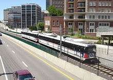
Clayton is served by the Metrolink light rail system. The city has two stations along the Blue Line: Clayton, and Forsyth. Metro also operates bus services in Clayton.
Major roads and highways
Major roads and highways in Clayton include Interstate 170, Brentwood Boulevard, Hanley Road, and Forest Park Parkway.[19] Old Bonhomme (renamed Forsythe Boulevard when it changes from North-South to East-West direction) in North Clayton is an ancient Native American trail. Wydown Boulevard in Clayton was called one of the nation's most dignified streets in the AIA Architecture Guide to St. Louis.
Transit centers
Education
Universities
Washington University in St. Louis is partially located in Clayton.[16][20] The city is also home to Fontbonne University and Concordia Seminary of the Lutheran Church–Missouri Synod.
Primary and secondary schools
The School District of Clayton operates public schools. There are three public elementary schools in Clayton, each feeding into the middle and high schools. There is Glenridge Elementary School, located in the Moorlands neighborhood, Captain Elementary School in the DeMun neighborhood near Concordia Seminary, and Meramec Elementary School in Davis Place. All three of these schools feed into Wydown Middle School, located on Wydown Boulevard, across from Washington University. This, in turn, feeds into Clayton High School, which is located next to Shaw Park, near downtown Clayton. Several of Clayton's elementary schools have been closed and/or repurposed. Gay School is now the Clayton Family Center, Maryland School has been leased to a series of daycare/elementary organizations,[21] DeMun School burned in a fire and was replaced by Ralph M. Captain Elementary, and in the wake of the Brown v. Board of Education case abolishing segregated schools, Crispus Attucks School was closed and demolished (an office building was constructed on its former grounds in downtown Clayton).[22]
Public libraries
St. Louis County Library operates the Mid-County Branch in Clayton.[16][23]
References
- 1 2 "US Gazetteer files 2010". United States Census Bureau. Archived from the original on June 26, 2012. Retrieved 2012-07-08.
- 1 2 "American FactFinder". United States Census Bureau. Retrieved 2012-07-08.
- ↑ "Population Estimates". United States Census Bureau. Retrieved 2014-11-27.
- 1 2 "American FactFinder". United States Census Bureau. Archived from the original on 2013-09-11. Retrieved 2008-01-31.
- ↑ "US Board on Geographic Names". United States Geological Survey. 2007-10-25. Retrieved 2008-01-31.
- ↑ "Find a County". National Association of Counties. Archived from the original on 2011-05-31. Retrieved 2011-06-07.
- ↑ "Race, Hispanic or Latino, Age, and Housing Occupancy: 2010 Census Redistricting Data (Public Law 94-171) Summary File (QT-PL), Clayton city, Missouri". U.S. Census Bureau, American FactFinder 2. Archived from the original on September 11, 2013. Retrieved October 19, 2011.
- ↑ Eaton, David Wolfe (1918). How Missouri Counties, Towns and Streams Were Named. The State Historical Society of Missouri. p. 359.
- ↑ "Annual Estimates of the Resident Population for Incorporated Places: April 1, 2010 to July 1, 2015". Retrieved July 2, 2016.
- ↑ United States Census Bureau. "Census of Population and Housing". Archived from the original on May 11, 2015. Retrieved November 26, 2014.
- 1 2 3 "City of Clayton CAFR" (PDF). City of Clayton. March 27, 2013. p. 85. Retrieved July 6, 2013.
- ↑ "We're Brown Shoe." Brown Shoe Company. Retrieved on January 23, 2010.
- ↑ "Frequently Asked Questions." Enterprise Rent-a-Car. Retrieved on June 14, 2009. Archived April 21, 2010, at the Wayback Machine.
- ↑ Van Der Werf, Martin. "Isle of Capri will move HQ to Creve Coeur." St. Louis Post-Dispatch. January 28, 2006. Third Edition, Business A31. Retrieved on August 19, 2009.
- ↑ "Employment Opportunities." Straub's Markets. Retrieved on July 12, 2010. Archived September 26, 2010, at the Wayback Machine.
- 1 2 3 "Clayton city, Missouri." U.S. Census Bureau. Retrieved on June 13, 2009.
- ↑ Saint Louis - Clayton Business District
- ↑ St. Louis Art Galleries - Clayton Business District
- ↑ Retrieved on November 12, 2009 Archived June 25, 2008, at the Wayback Machine.
- ↑ "Danforth Campus Map." Washington University in St. Louis. Retrieved on June 13, 2009.
- ↑ Maryland School to Host Wilson Students Displaced by Fire - Schools - Clayton-Richmond Heights, MO Patch
- ↑ Clayton History Society | History Of Clayton Schools
- ↑ "Mid-County Branch." St. Louis County Library. Retrieved on August 18, 2009.
External links
| Wikimedia Commons has media related to Clayton, Missouri. |
| Topics |  | |
|---|---|---|
| Central city | ||
| Largest cities (over 50,000 in 2010) | ||
| Medium-sized cities (over 20,000 in 2010) | ||
| Largest towns and villages (over 10,000 in 2010) |
| |
| Missouri Counties | ||
| Illinois Counties | ||
| Subregions | ||