Merseyside
| Merseyside | |
|---|---|
| County | |
 Merseyside in England | |
| Sovereign state | United Kingdom |
| Country | England |
| Region | North West England |
| Established |
1974 (Local Government Act 1972) |
| Ceremonial county | |
| Area | 645 km2 (249 sq mi) |
| • Ranked | 43rd of 48 |
| Population (mid-2014 est.) | 1,391,113 |
| • Ranked | 9th of 48 |
| Density | 2,141/km2 (5,550/sq mi) |
| Ethnicity |
91.8% White British 2.7% Other White 2.2% Asian 1% Black 1.6% Mixed 0.8% Other |
| Metropolitan county | |
| Government | Liverpool City Region Combined Authority |
| Area | 645 km2 (249 sq mi) |
| ONS code | 2B |
| NUTS | UKD72, UKD73, UKD74 and part of UKD71 |
 Districts of Merseyside | |
| Districts | |
| Members of Parliament | |
| Time zone | GMT (UTC) |
| • Summer (DST) | BST (UTC+1) |
Merseyside (/ˈmɜːrzisaɪd/) is a metropolitan county in North West England, with a population of 1.38 million.[1] It encompasses the metropolitan area centred on both banks of the lower reaches of the Mersey Estuary, and comprises five metropolitan boroughs: Knowsley, St Helens, Sefton, Wirral, and the city of Liverpool. Merseyside, which was created on 1 April 1974 as a result of the Local Government Act 1972, takes its name from the River Mersey.
Merseyside spans 249 square miles (645 km2) of land which border Lancashire (to the north-east), Greater Manchester (to the east), Cheshire (to the south and south-west) and the Irish Sea to the west. North Wales is across the Dee Estuary. There is a mix of high density urban areas, suburbs, semi-rural and rural locations in Merseyside, but overwhelmingly the land use is urban. It has a focused central business district, formed by Liverpool City Centre, but Merseyside is also a polycentric county with five metropolitan districts, each of which has at least one major town centre and outlying suburbs. The Liverpool Urban Area is the fifth most populous conurbation in England, and dominates the geographic centre of the county, while the smaller Birkenhead Urban Area dominates the Wirral Peninsula in the south.
For the 12 years following 1974 the county had a two-tier system of local government; district councils shared power with the Merseyside County Council. The county council was abolished in 1986, and so its districts (the metropolitan boroughs) are now effectively unitary authority areas. However, the metropolitan county continues to exist in law and as a geographic frame of reference,[2] and several county-wide services are co-ordinated by authorities and joint-boards, such as Merseytravel (for public transport), Merseyside Fire and Rescue Service and the Merseyside Police (for law-enforcement); as a ceremonial county, Merseyside has a Lord Lieutenant and a High Sheriff. Merseyside is joined by the neighbouring borough of Halton to form the Liverpool City Region, which together forms a local enterprise partnership and combined authority area.
Merseyside is an amalgamation of 22 former local government districts from the former administrative counties of Lancashire, Cheshire and six autonomous county boroughs centred on Birkenhead, Bootle, Liverpool, Southport, St Helens, and Wallasey.
History
Merseyside was designated as a "Special Review" area in the Local Government Act 1958, and the Local Government Commission for England started a review of this area in 1962, based around the core county boroughs of Liverpool/Bootle/Birkenhead/Wallasey. Further areas, including Widnes and Runcorn, were added to the Special Review Area by Order in 1965. Draft proposals were published in 1965, but the commission never completed its final proposals as it was abolished in 1966.
Instead, a Royal Commission was set up to review English local government entirely, and its report (known as the Redcliffe-Maud Report) proposed a much wider Merseyside metropolitan area covering southwest Lancashire and northwest Cheshire, extending as far south as Chester and as far north as the River Ribble. This would have included four districts: Southport/Crosby, Liverpool/Bootle, St Helens/Widnes and Wirral/Chester. In 1970 the Merseyside Passenger Transport Executive (which operates today under the Merseytravel brand) was set up, covering Liverpool, Sefton, Wirral and Knowsley, but excluding Southport and St. Helens.
The Redcliffe-Maud Report was rejected by the incoming Conservative Party government, but the concept of a two-tier metropolitan area based on the Mersey area was retained. A White Paper was published in 1971. The Local Government Bill presented to Parliament involved a substantial trimming from the White Paper, excluding the northern and southern fringes of the area, excluding Chester, Ellesmere Port (and, unusually, including Southport, whose council had requested to be included). Further alterations took place in Parliament, with Skelmersdale being removed from the area, and a proposed district including St Helens and Huyton being subdivided into what are now the metropolitan boroughs of St Helens and Knowsley.
Merseyside was created on 1 April 1974 from areas previously parts of the administrative counties of Lancashire and Cheshire, along with the county boroughs of Birkenhead, Wallasey, Liverpool, Bootle, and St Helens. Following the creation of Merseyside, Merseytravel expanded to take in St Helens and Southport.
| post-1974 | pre-1974 | ||||
|---|---|---|---|---|---|
| Metropolitan county | Metropolitan borough | County boroughs | Non-county boroughs | Urban districts | Rural districts |
 |
Knowsley | Huyton with Roby • Kirkby • Prescot • | West Lancashire • Whiston • | ||
| Liverpool | Liverpool | ||||
| Sefton | Bootle • Southport • | Crosby • | Formby • Litherland • | West Lancashire • | |
| St Helens | St Helens | Ashton-in-Makerfield • Billinge and Winstanley • Haydock • Rainford • | Whiston • | ||
| Wirral | Birkenhead • Wallasey • | Bebington • | Hoylake • Wirral • | ||
Between 1974 and 1986 the county had a two-tier system of local government with the five boroughs sharing power with the Merseyside County Council. However, in 1986 the government of Margaret Thatcher abolished the county council along with all other metropolitan county councils, and so its boroughs are now effectively unitary authorities.
Geography

Merseyside is divided into two parts by the Mersey Estuary, the Wirral is located on the west side of the estuary, upon the Wirral Peninsula and the rest of the county is located on the east side of the estuary. The eastern part of Merseyside borders onto Lancashire to the north, Greater Manchester to the east, with both parts of the county bordering Cheshire to the south. The territory comprising the county of Merseyside previously formed part of the administrative counties of Lancashire (east of the River Mersey) and Cheshire (west of the River Mersey).
The two parts are linked by the two Mersey Tunnels, the Mersey Railway, and the Mersey Ferry.
Identity
To express location within the Merseyside area by the preposition on – thus "on Merseyside" as opposed to "in Merseyside" – was traditionally the more usual. However, the logic of suggestions in support of this from some quarters (that, after all, one would always be "on" the side of the Mersey, not "in" it) falls down; since it is, in fact, entirely possible to be situated [both] "in" or "on" [either] “side” of the River Mersey and area(s) thus designated. Therefore, more recent usage tends to draw distinctions between the geographical "Merseyside" – for which "on" is considered appropriate – and the Metropolitan county of "Merseyside", for which "in" is used.
Ipsos MORI polls in the boroughs of Sefton and Wirral in the 2000s showed that in general, residents of these boroughs identified slightly more strongly to Merseyside than to Lancashire or Cheshire respectively, but their affinity to Merseyside was more likely to be "fairly strong" than "very strong".[3]
Local government

Metropolitan boroughs
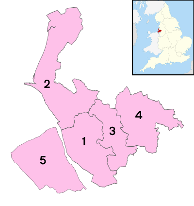
Merseyside contains the metropolitan boroughs of Liverpool, Knowsley, Sefton, St Helens and Wirral.
County level functions
Despite the abolition of the county council some local services are still run on a county-wide basis, now administered by joint-boards of the five metropolitan boroughs; these include the:
- Merseyside Police
- Merseyside Fire & Rescue Service
- Merseytravel (who are also responsible for the Merseyrail network)
- Merseyside Waste Disposal Authority
- Merseyside Pension Scheme, administered by Wirral Borough Council, with offices in Liverpool
Liverpool City Region
The Liverpool City Region Combined Authority, which includes the five boroughs and the Borough of Halton is to have a mayor to be elected in May 2017. [4]
Economy
This is a chart of trend of regional gross value added of Merseyside at current basic prices published (pp. 240–253) by Office for National Statistics with figures in millions of British Pounds Sterling.
| Year | Regional Gross Value Added[note 1] | Agriculture[note 2] | Industry[note 3] | Services[note 4] |
|---|---|---|---|---|
| 1995 | 10,931 | 50 | 3,265 | 7,616 |
| 2000 | 13,850 | 29 | 3,489 | 10,330 |
| 2003 | 16,173 | 39 | 3,432 | 12,701 |
Greater Merseyside
Other nearby towns are not part of Merseyside, such as Skelmersdale, Ormskirk, Warrington, Runcorn, Widnes and Ellesmere Port (all parts of either Cheshire or Lancashire), but the designation "Greater Merseyside" has sometimes been adopted for Merseyside and these six towns unofficially. This also has a semi-official usage by some local authorities and organisations and is used by Geographers' A-Z Map Company for their Merseyside Street Atlas.[5] However, a separate 'City region', comprising Merseyside and Halton, has some official recognition as being Greater Merseyside, although it has also been referred to as Liverpool City Region. Halton also forms part of the Merseyside NUTS region.[6]
Places of interest
See also
- List of Lord Lieutenants of Merseyside
- List of High Sheriffs of Merseyside
- 1911 Liverpool general transport strike
- List of Sites of Special Scientific Interest in Merseyside
Notes
References
- ↑ "2009 Mid Year Estimates – Table 9 ONS". statistics.gov.uk. Retrieved 9 September 2010.
- ↑ Office for National Statistics. "Gazetteer of the old and new geographies of the United Kingdom" (PDF). statistics.gov.uk. p. 48. Retrieved on 6 March 2008.
•Office for National Statistics (17 September 2004). "Beginners' Guide to UK Geography: Metropolitan Counties and Districts". statistics.gov.uk. Retrieved on 6 March 2008.
•"North West – Electoral Commission". The Electoral Commission. Retrieved on 7 July 2008. - ↑ Sefton poll, where 51% residents belonged strongly to Merseyside, and compared with 35% to Lancashire; Wirral poll, where 45% of residents belonged strongly to Merseyside; compared with 30% to Cheshire. In both boroughs, "very strongly" ratings for the historic county were larger than that for Merseyside, but "fairly strongly" was lower.
- ↑ "Liverpool city region metro mayor: what is it, when will we get one and who will it be?". Liverpool Echo. 18 May 2016. Retrieved 16 July 2016.
- ↑ Merseyside Street Atlas. Geographers' A-Z Map Co Ltd. ISBN 978-0850399653.
- ↑ "North West (England)". Office for National Statistics. Retrieved 28 November 2015.
- ↑ "Art Galleries - Museum - Glass Blowing- Victorian Furnace". The World of Glass. Retrieved 28 November 2015.
Further reading
- Dickinson, Joseph (1851). The Flora of Liverpool. Liverpool: Deighton and Laughton.
External links
| Wikimedia Commons has media related to Merseyside. |
| Wikivoyage has a travel guide for Merseyside. |
- Merseyside at DMOZ
- Merseytravel website
- Merseyside.com local guide, A-Z, street index
- Merseyside Today - regional guide
- Mersey Reporter History - Merseyside History
- Merseyside Businesses online
- Mersey Life - Community

Coordinates: 53°25′N 3°00′W / 53.417°N 3.000°W