Khulna Division
| Khulna Division খুলনা বিভাগ | ||
|---|---|---|
| Division of Bangladesh | ||
| ||
 Location of Khulna in Bangladesh | ||
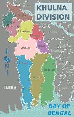 Districts of Khulna Division | ||
| Coordinates: 22°55′N 89°15′E / 22.917°N 89.250°ECoordinates: 22°55′N 89°15′E / 22.917°N 89.250°E | ||
| Country |
| |
| Capital | Khulna | |
| Area | ||
| • Total | 22,284.22 km2 (8,603.99 sq mi) | |
| Population (2011 census) | ||
| • Total | 15,687,759 | |
| • Density | 700/km2 (1,800/sq mi) | |
| Time zone | BST (UTC+6) | |
| ISO 3166 code | BD-D | |
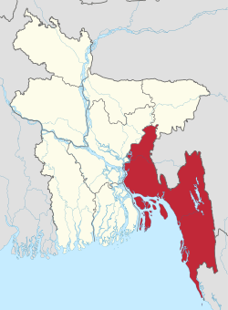
Khulna Division (Bengali: খুলনা বিভাগ) is one of the seven divisions of Bangladesh and is in the south-west of the country. It had an area of 22,285 km2 and a population of 15,563,000 at the 2011 Census (preliminary returns). Its headquarters is Khulna city in Khulna District.
Geography
The Khulna division borders the Indian state of West Bengal to the west, the Rajshahi Division to the north, the Dhaka and Barisal Divisions to the east, and has a coastline on the Bay of Bengal to the south. It is part of the Ganges River delta or Greater Bengal Delta. Other rivers include the Madhumati River, the Bhairob River and the Kopotokkho River. The region also includes several islands in the Bay of Bengal.
Administrative districts
The division was formed in 1960.[1] Khulna Division consists of the following ten districts (zilas), subdivided into 59 sub-districts (upazilas):[2]
| District | Administrative centre | Area in km2. | Population 1991 Census | Population 2001 Census | Population 2011 Census |
|---|---|---|---|---|---|
| Bagerhat District | Bagerhat | 3,959.11 | 1,431,322 | 1,549,031 | 1,476,090 |
| Chuadanga District | Chuadanga | 1,174.10 | 807,164 | 1,007,130 | 1,129015 |
| Jessore District | Jessore | 2,606.94 | 2,106,996 | 2,471,554 | 2,764,547 |
| Jhenaidah District | Jhenaidah | 1,964.77 | 1,361,280 | 1,579,490 | 1,771,304 |
| Khulna District | Khulna | 4,394.45 | 2,010,643 | 2,378,971 | 2,318,527 |
| Kushtia District | Kushtia | 1,608.80 | 1,502,126 | 1,740,155 | 1,946,838 |
| Magura District | Magura | 1,039.10 | 724,027 | 824,311 | 918,419 |
| Meherpur District | Meherpur | 751.62 | 491,917 | 591,430 | 655,392 |
| Narail District | Narail | 967.99 | 655,720 | 698,447 | 721,668 |
| Satkhira District | Satkhira | 3,817.29 | 1,597,178 | 1,864,704 | 1,985,959 |
| Total | 10 | 22,284.22 | 12,688,3832 | 14,705,223 | 15,687,759 |
Economy
Khulna was the backbone of the East Pakistan's main foreign currency earner, the jute industry. There are many large jute mills in Khalishpur near Khulna city processing jute fiber, besides the other heavy industries like Khulna News Print Mills and Khulna Hardboard Mills. The country's second seaport, Mongla Port, and the country's only ship building yard is in Khulna division.
The largest mangrove forest in the world — the Sundarban — is spread over the three most southerly districts of Satkhira, Khulna and Bagherhat.
Education
The division contains educational institutions including:
- Universities
- Khulna University;[3]
- Khulna University of Engineering and Technology;
- Jessore Science and Technology University;
- Islamic University, Bangladesh;
- Khulna medical college;
- Jessore Medical College;
- Kushtia Medical College
- Satkhira Medical College
- Colleges
- Government B L College;
- Khulna Polytechnic Institute;[4] Khulna;
- Mangrove Institute of Science and Technology;[5]
- City Polytechnic Institute;
- Khanjahan Ali college of Engineering and Technology;
- North South Polytechnic Institute Khulna;
- Daulatpur College (Day/Night), Daulatpur, Khulna;
- Khulna Girls College;
- Khulna Public College;[6]
- Majid Memorial City College, Khulna;
- M.A. Majid College, Dighalia, Khulna;
- Michael Modhushudon College (MM College), Jessore;
- Shundorban College;
- Cantonment Public School and College;
- Jhenaidah Cadet College;
- Phultala M.M. College;
- Khan Jahan Ali Ideal College;
Keshobpur College, Keshobpur, Jessore Chuknagor College, Dumuria, Khulna
- Pioneer Govt Mohila College.
- Schools
- Khulna Zilla School;
- Khulna Collegiate School;
- Coronation Govt. Girls School;
- Government Daulatpur Muhsin High School;
- Dighalia M.A. Majid Secondary School, Dighalia, Khulna;
- Fatima Girls High School;
- Jessore Cantonment Public School;
- Keshobpur Pilot School & College
- Mangolkot M.L High School, Keshobpur, Jessore
- Adarsho Girls' School, Keshobpur, Jessore
- Rotary School, Khalishpur, Khulna;
- S.B.S.N, Damoder;
- M.M. High School;
- Khulna Lions Schools;
- St. Joseph's High School;
- St. Zavier's School;
- Rev. Paul High School;
- Rosedale International School;
- Kumira High School;
- Udayan Khulna Zilla Police School;
- Khulna Engineering University School.
- Other Educational Institutes
Khulna has six integrated general and vocational (IGV) schools and one technical school of UCEP (Underprivileged Children's Educational Programs), which is a non-profitable organization.
- UCEP-K C C School, Rupsha;
- UCEP-Sonadanga School, Sonadanga;
- UCEP-M A Majid School, Fulbarigate;
- UCEP-Khalishpur School, Khalishpur;
- UCEP-Zohra Samad School, Tootpara;
- UCEP-Wazed Ali School, Banorgati.
The technical school is Khulna Mohsin Technical School, which is situated at 7, Junction Road, Baikali, Khulna.
Kushtia Zilla School, Kushtia is one of the best schools in Khulna division and reputed in Bangladesh. In higher secondary level Kushtia Govt. College, Kushtia is playing the same role as KZS. For higher education Islamic University, Kushtia have become model in Bangladesh, and thus in Khulna division education level increasing day by day.
Newspapers and magazines
Daily and weekly newspapers are published from Khulna, including:
- (গণমত ডটকম) Online News Paper,
- (সাতক্ষীর নিউজ) Satkhira News.com,
- 'Daily Purbanchal,
- [the weekly khulnanchal. Editor-Mizanur Rahman Milton]
- Khulna News,
- Daily Shomoyer Khobor,
- Daily Tribune,
- Daily Janmobhumi,
- Daily Anirbhan,
- Daily Probaho etc.[7]
Daily Gramer Kagoj Daily Spondon Daily Lokshomaj
Religion
Islam is in majority and about 88% of total population follow Islam according to 2011. Hinduism is second largest religion in Khulna and about 11% of total population are Hindu,1% follow other religion.
Language
Bengali is the official language of Bangladesh. There are a few thousand people of Pakistani or Bihari origin who speak Urdu; those people were stranded after the liberation war between Bangladesh (then East Pakistan) and Pakistan. Bihari people were from the state of Bihar and surrounding areas of India. They migrated to East Bengal or East Pakistan (presently Bangladesh) at the time of partition of India in 1947. These Bihari people were against formation of Bangladesh in 1971 as they favored Pakistan, but after the war Pakistan refused to take them back. They use a mixed form of Urdu language, especially mixed with Bhojpuri, Bengali, Hindi and English.
English is widely used as the business language. Most of the educated people can speak and understand English. As English is used as medium of education in some educational institutions.
Munda, Domari, Romani, Telugu, Gujarati, Marwari and other minor languages are used by minority communities usually found in the cities.
Notable persons
- Saint Khan Jahan Ali
- Firoz Mahmud- contemporary visual artist, painter
- Nilima Ibrahim- educationist, littérateur and social worker
- Soumya Sarkar- cricketer
- Fakir Lalon Shah, Baul legend
- Acharya Prafulla Chandra Ray
- Prafulla Chandra Sen Former Chief Minister of West Bengal
- Habibul Bashar Former captain, Bangladesh national cricket team
- Abdur Razzak, Bangladesh national cricket team
- Sheikh Salahuddin - Former cricketer
- Dr. Jamal Nazrul Islam Physicist
- Shakib Al Hasan, Bangladesh national cricket team
- Michael Madhusudan Datta - Poet and Dramatist
- Syed Ali Ahsan, poet
- Mahendra Lal Bose - Philanthropist and Educationist
- Mashrafe Mortaza, Bangladesh national cricket team
- Munshi Mohammad Meherullah, Muslim poet, religious leader and social reformer
- Syed Rasel, Bangladesh national cricket team
- Mustafizur Rahman, Bangladesh National Cricket Team
References
- ↑ Sajahan Miah (2012). "Khulna Division". In Sirajul Islam and Ahmed A. Jamal. Banglapedia: National Encyclopedia of Bangladesh (Second ed.). Asiatic Society of Bangladesh.
- ↑ Census figures for 1991, 2001 and 2011 are from Bangladesh Bureau of Statistics, Population Census Wing. The 2011 Census figures are based on preliminary results.
- ↑
- ↑
- ↑ MIST
- ↑
- ↑ http://www.khulnanews.com
External links
| Wikivoyage has a travel guide for Khulna Division. |
 |
Rajshahi Division | Dhaka Division | | |
| West Bengal, India | |
|||
| ||||
| | ||||
| Bay of Bengal | Barisal Division |


| Barisal Division | 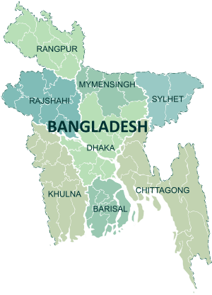 | |
|---|---|---|
| Chittagong Division | ||
| Dhaka Division | ||
| Khulna Division | ||
| Mymensingh Division | ||
| Rajshahi Division | ||
| Rangpur Division | ||
| Sylhet Division | ||