Knocknadobar
| Knocknadobar | |
|---|---|
| Cnoc na dTobar | |
 | |
| Highest point | |
| Elevation | 690 m (2,260 ft) [1] |
| Prominence | 565 [1] |
| Listing | Marilyn |
| Coordinates | 51°59′35″N 10°10′32″W / 51.99302°N 10.175489°WCoordinates: 51°59′35″N 10°10′32″W / 51.99302°N 10.175489°W |
| Geography | |
 Knocknadobar | |
| Parent range | Mountains of the Iveragh Peninsula |
| OSI/OSNI grid | V506845 |
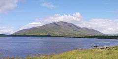
Knocknadobar (Irish: Cnoc na dTobar, meaning "mountain of the wells") is one of the main mountains of the Iveragh Peninsula in County Kerry, Ireland.
Etymology
Its name means "mountain of the wells" and is thought to refer to the four small lakes on its slopes.
Geography
The mountain lies northeast of Cahersiveen, just north of the N70 road, on the coast of Dingle Bay. It is 690 m (2,264 ft) in height.
History
Knocknadobar is famous for its "stations of the cross" on the path to the summit and an altar at the top where mass is said yearly. A cross beside the altar was erected in June 1884.
References
- Dillon, Paddy (1993). The Mountains of Ireland. ISBN 1-85284-110-9.
- 1 2 "Iveragh NW Area / Knocknadobar". MountainViews. Ordnance Survey Ireland. Retrieved March 7, 2015.
External links

Lists of Marilyns | |
|---|---|
This article is issued from Wikipedia - version of the 12/6/2015. The text is available under the Creative Commons Attribution/Share Alike but additional terms may apply for the media files.