Slieve Mish Mountains
| Slieve Mish Mountains | |
|---|---|
| Irish: Sliabh Mis | |
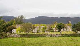 Ruins of the Augustinian Priory St. Mary de Bello Loco in front of the southern side of the Slieve Mish Mountains | |
| Highest point | |
| Peak | Baurtregaum |
| Elevation | 851 m (2,792 ft) |
| Dimensions | |
| Length | 19 km (12 mi) E-W |
| Geography | |
| Country | Republic of Ireland |
| Provinces of Ireland | Munster |
| Geology | |
| Type of rock | sandstone |
The Slieve Mish Mountains (Sliabh Mis in Irish) are a mountain range found in County Kerry in Ireland.
Geography
Overlooking Tralee Bay on the northern side and Dingle Bay on the south, they extend for approximately 19 km from east to west. They run from the mainland just south of Tralee along the centre of the neck of the Dingle Peninsula, before ending in a series of low foothills and deep river valleys which separate them from the Mountains of the central Dingle Peninsula further to the west. The mountain range is relatively narrow, extending only about 7 km from north to south. The mountains form a high ridge of sandstone which was deeply incised by glaciers in the last ice age, leaving behind U-shaped valleys and corrie lakes. Dozens of peaks are to be found here, only a few of them named: Glanbrack Mountain, 664 m; Baurtregaum (Barr Trí gCom), 851 m high and the tallest peak in the range; Gearhane (An Géarán), 792 m; Caherconree (Cathair Conraoi), 835 m.
Etymology
"Sliabh Mish" is named after a mythological Celtic princess who was famed for being cruel.
See also
Coordinates: 52°12′N 9°46′W / 52.200°N 9.767°W
