Kothamangalam
| Kothamangalam കോതമംഗലം | |
|---|---|
| Municipality and town | |
|
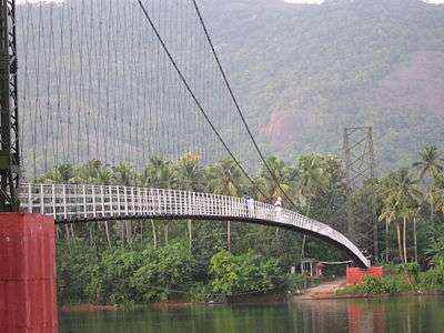
Inchathotty thookku palam | |
 Kothamangalam  Kothamangalam Location in Kerala, India | |
| Coordinates: 10°4′48″N 76°37′12″E / 10.08000°N 76.62000°ECoordinates: 10°4′48″N 76°37′12″E / 10.08000°N 76.62000°E | |
| Country |
|
| State | Kerala |
| District | Ernakulam |
| Government | |
| • Member of Legislative Assembly | Antony John(LDF/CPM) |
| • Chairperson, Kothamangalam Municipality | Manju Siju (Indian National Congress) |
| Area | |
| • Municipality and town | 37.45 km2 (14.46 sq mi) |
| Population (2011) | |
| • Density | 3,015/km2 (7,810/sq mi) |
| • Metro | 114,574 |
| Languages | |
| • Official | Malayalam, English |
| Time zone | IST (UTC+5:30) |
| PIN | 686691 |
| Telephone code | 0485 |
| Vehicle registration | KL-44 |
| Sex ratio | 102.05 ♂/♀ |
| Website |
kothamangalammunicipality |


Kothamangalam is a Municipality in the eastern part of Ernakulam district in the Indian state of Kerala. It is around 14 km northeast of the town of Muvattupuzha and 55 km north east of Kochi city. The town is in the foothills of the Western Ghats mountain ranges. The highway NH-49 Ernakulam – Madurai – Rameswaram passes through Kothamangalam.
The town serves as the headquarters of a taluk and a municipality of the same name. Kothamangalam is known as a trading center for spices and forest products. It is also famous for its ancient Syrian Christian churches.
History
According to the historical evidence, Kothamangalam was a place of prominence during the rule of the First Chera Dynasty, the dynasty that ruled Kothamangalam from around 300 BC to the first millennium. Cheras were also known as Kothai. The capital of Chera Kingdom was Karur. This has led some historians like Professor Joseph Mundasseri etc. to claim that Thrikkariyoor, a village 3 km north of Kothamangalam could have been the ancient Karur, the capital of Cheras. This claim has not found wide support. Several historians believe Karur (or 'Vanchi' or 'Muziris') was near the present-day Pattanam (North Paravur).
It is evident from the Sangam literature of the period and the archeological finds from the area prove that the place had, indeed, been an important town during the rule of Chera kingdom. The description of some places mentioned in Silappatikaram fits the description of places adjoining Kothamangalam. The Siva temple at Thrikkariyoor dates back to the early centuries of first millennium. Thrikkariyoor also has one of the earliest Brahmin settlements in Kerala. Chelamalai, near Bhoothathankettu in Kothamangalam, is regarded by some as the Summer Palace of Cheras. Stone ruins were found there and Nanangadis (Burial urns) have been excavated from the place.
Egyptian coins of the 7th and 8th centuries were recovered from places near Kothamangalam in 1962. The ancient trade route to Madhurai was also through Kothamangalam. The popularity of Kothamangalam during the past is evident from the old Malayalam saying, 'Ethappaa Kothamangalam?' which means 'Where is Kothamangalam?' — used in dialogues to indicate that the person to whom this is asked is so ignorant that he does not know where Kothamangalam is.
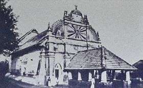
Marth Mariam Church (popularly called 'Valiyapally') belonging to the Jacobite Syrian Christian Church was completed during fourth century AD by a few Syrian families. A division happened among the members of the church and this divided group established one cross near the church. Later, these eighteen families constructed a church like the parent church in the name of St. Thomas. The Marthoman CheriyaPally was built during AD 1455 by some members of Marth Mariam Church. This church is the resting place of Catholicos Baselios Yeldo, a saint of the Jacobite Syriac Orthodox Church. The church is a very popular Christian pilgrimage centre in Kerala.
Later, the importance of Kothamangalam dwindled. Kothamangalam was first under the rule of "Karthakkanmar" related to Vemopolinadu royalty and laterTravancore Kingdom until India became independent. After Indian Independence, from 1949 to 1956, Kothamangalam was under Muvattupuzha taluk which was a part of the Kottayam district in Travancore-Cochin state.[1] In 1956, when Kerala state was formed, Kothamangalam and Muvattupuzha remained as a part of Kottayam district till 1958. Kothamangalam taluk was created from Muvattupuzha taluk on 26 January 1972. It was composed of Kothamangalam, Keerampara, Malippara, Kottapady, Pindimana, Nellikuzhi, Pothanicad, Varappetty, Kadavoor and Pallarimanagalam villages. Later Neriamangalam and Thrikkariyoor were added to the taluk in 1981 and Kuttampuzha in 1997 also. Kothamangalam became a municipality in 1978.
Geography
Kothamangalam is situated in the eastern part of the Ernakulam district. Kothamangalam is known as the Gateway of Highrange. According to the division of the geographical regions of Kerala to High-lands, Mid-lands and Low-lands, Kothamangalam is in a Mid-land region.[2] The general topography is hilly. The Munnar hill station is around 85 kilometres from Kothamangalam.
The river Periyar, the largest river in Kerala, flows through the taluk. The dams built across Periyar at Edamalayar, Lower Periyar (near Neriamangalam) and Bhoothathankettu for hydroelectricity generation and irrigation purposes are located in the Kothamangalam taluk. Kothamangalamar, a small river which flows through the town goes to join Kaliyar and Thodupuzhayar to form the Muvattupuzhayar which is the second largest river in Ernakulam district.
The taluk is rich in flora and fauna. Tropical evergreen and semi-evergreen and moist deciduous forests are found in the region. Thattekad Bird Sanctuary located 13 km from Kothamangalam town is the first bird sanctuary in Kerala. Salim Ali, one of the best known ornithologists described this sanctuary as the richest bird habitat on peninsular India. Several rare birds like the Ceylon frogmouth, Bourdillon’s long eared Indian nightjar, peninsular bay owl, crimson-throated barbet and Malabar hornbill are found here. Common animals include leopards, sloth bears, elephants and porcupines.
Laterite is the major soil type found in the taluk. Rubber and teak are extensively cultivated in plantations. The other crops include spices like pepper, coconut palms, tapioca, paddy, plantain, pulses and nutmeg. Allied agricultural activities like fishing, diary and poultry are also popular.
|

Climate
The climate of the region is tropical humid, with temperatures ranging from 20 °C to 32 °C. The hottest months are April–May and the coldest December–January. The region receives heavy annual rainfall of around 2500–3600 mm. The rainfall is mainly concentrated from June to October. The best time to visit Kothamangalam is between October and March. The South-west monsoon and the Northeast monsoon bring rains to the region. Neriamangalam gets the highest average rainfall in the state of Kerala. So this place is aptly hailed as 'The Cherrapunjee of Kerala'.
Demographics
Kothamangalam urban agglomeration has a total population of 114,574 according to the 2011 census,[3] 56,753 being males and 57,821 females. There are 30,067 households in the Kothamangalam municipality.[4] The literacy rate of Kothamangalam Agglomeration is 95.24%. In comparison, the National Urban average literacy in India is 85%. Literacy rate of males and females stood at 97.04% and 93.48% respectively. Total literates in Kothamangalam Urban Agglomeration were 98,398, of which 49,412 were males and remaining 48,986 were females.
The town's population consists of Syrian Christians, Hindus and Muslims. Syrian Jacobites and Syrian Catholics coexist with each other. The language Malayalam is used widely as in the rest of Kerala.
Administration
Kothamangalam municipality was formed in 1978 and is the headquarters of the Kothamangalam Taluk. The municipality has an area of 37.45 km2 and is divided into 31 electoral wards. Elections to the local self bodies are held once every five years. From the elected Municipal Councilors, a chairman and vice-chairman are elected. The present chairperson of the municipality is Manju Siju and the vice-chairman is A.G George .
Kothamangalam is part of the Idukki Lok Sabha constituency.[5] Till 2009, it was part of Muvattupuzha Lok Sabha constituency. Kothamangalam is also represented in the Kerala Legislative Assembly as a constituency. The panchayats in Kothamangalam Taluk are Nellikuzhi, Kottapady, Pindimana, Varapetty, Pallarimangalam, Kavalangad, Keerampara, Kuttampuzha. The block panchayat is also Kothamangalam.
Places of worship
Kothamangalom Martha Mariyam Valiya Pally and Marthoma Cheriya Pally are major pilgrim centers of the Jacobite Syrians . The tomb of Eldho Mor Baselios attracts nearly 1 lakh pilgrims on 2 and 3 October.[6] The St. George's Cathedral Syro-Malabar Catholic was constructed in 1770 by the Catholic faction of Syrian Christians.
Pallikal kavu Bhagavathy temple is an old temple ( website) at Inchoor.,Pallikal Kavu (Malayalam: പള്ളിക്കൽ കാവ് )is a Hindu temple located in Kothamangalam, Ernakulam District, VarappettyGrama Panchayathu in Kerala, India. The main deity is the Goddess Parvati. Ayyappa, Ganesha and Bhadrakali are sub-deities. The main celebration is Kumbha Pooram between January and February every year. The temple holds history of several decades with relations to nearby temples and even to a Christian church at Kothamangalam. The shrine draws thousands of devotees
Sri Maha Ganapthy Temple Mathirappilly famous for its rituals on "Vinayaka Chathurdhi" every year. Ilanjikkal Kavu Venduvazhy is another temple near Kothamangalam famous for Nalikeramuttu and Pushpavrishti.
Thrikkariyoor Mahadeva Temple, Kothamangalam. It is declared as one of the 11 holy temples in Kerala. Thrikkariyur is believed to be the capital of ancient Chera Kingdom.It is near to the Ekachakra gramam(Kothamangalam) which was famous from time immemorial.It is believed that Aryan Brahmins were settled here in Kothamnagalam even in the 1st century AD.There existed tremendous commercial trade between Pandyan Kingdom and Muzris in the ancient times and it was through the royal route of Madura -Alwaye which passes through Kothamangalam.
Education
Major education institutes in the town include Nangelil ayurveda medical collge one of the famous ayurveda collges in south India, Athanasius College, Mar Athanasius College of Engineering, Mar Basil School, St. George School, Mar Athanasius English Medium School, St. Augustine Girls High School and Yeldo Mar Baselios College.St. George Higher Secondary School, Mar Basil Higher Secondary School and GVHSS Mathirappilly have won several Kerala state sports and athletics championships.[7] Mar Athanasius College of Engineering was established in 1961. It is the first engineering college established under Christian management in Asia. There are three colleges teaching dental medicine in the town, namely St Gregorios Dental College, Mar Baselios Dental College, Indira Gandhi Institute of Dental Sciences.
Transport
Air
The air gateway to Kothamangalam is the Cochin International Airport (CIAL) located at Nedumbassery, which is about 32 km and handles both domestic and international flights.[8] It is the first international airport in India to be built without Central Government funds [9] and is the world's first fully solar energy powered airport.
Road
National Highway 85 passes through the centre of Kothamangalam.
References
- ↑ K. M. Mathew, ed. (2006). Manorama Year Book. Malayala Manorama. p. 116.
- ↑ Eranakulam. Kerala Government Statistics
- ↑ Kothamangalam Metropolitan Urban Region Population 2011 Census. Census2011.co.in. Retrieved on 2015-04-19.
- ↑ Kothamangalam Block. Ernakulam.nic.in. Retrieved on 2015-04-19.
- ↑ "Assembly Constituencies – Corresponding Districts and Parliamentary Constituencies" (PDF). Kerala. Retrieved 2008-10-19.
- ↑ Marthoma Cheriapally Kothamangalam. Cheriapally.org. Retrieved on 2015-04-19.
- ↑ St. George's, Kothamangalam pips Mar Basil by half-a-point. The Hindu. 22 December 2010.
- ↑ "The Official Website of Cochin International Airport". Cochin-airport.in. Retrieved 14 October 2010.
- ↑ "A novel venture in the history of Indian Aviation". Cochin International Airport. Retrieved 23 May 2006.
External links
| Wikimedia Commons has media related to Kothamangalam. |