La Chapelle-d'Abondance
| La Chapelle-d'Abondance | ||
|---|---|---|
|
| ||
| ||
 La Chapelle-d'Abondance | ||
|
Location within Auvergne-Rhône-Alpes region  La Chapelle-d'Abondance | ||
| Coordinates: 46°17′46″N 6°47′17″E / 46.2961°N 6.7881°ECoordinates: 46°17′46″N 6°47′17″E / 46.2961°N 6.7881°E | ||
| Country | France | |
| Region | Auvergne-Rhône-Alpes | |
| Department | Haute-Savoie | |
| Arrondissement | Arrondissement of Thonon-les-Bains | |
| Canton | Canton of Abondance | |
| Intercommunality | Syndicat Intercommunal à la Carte de la Vallée d'Abondance | |
| Government | ||
| • Mayor (2014–2020) | Bernard Maxit | |
| Area1 | 37.85 km2 (14.61 sq mi) | |
| Population (1999)2 | 719 | |
| • Density | 19/km2 (49/sq mi) | |
| Time zone | CET (UTC+1) | |
| • Summer (DST) | CEST (UTC+2) | |
| INSEE/Postal code | 74058 / 74360 | |
| Elevation | 975–2,430 m (3,199–7,972 ft) | |
|
1 French Land Register data, which excludes lakes, ponds, glaciers > 1 km² (0.386 sq mi or 247 acres) and river estuaries. 2 Population without double counting: residents of multiple communes (e.g., students and military personnel) only counted once. | ||

La Chapelle-d'Abondance is a commune in the Haute-Savoie department in the Auvergne-Rhône-Alpes region in south-eastern France.
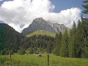
Located in the northern French Alps, the village lies at the heart of a farming valley in Haute-Savoie. Nestling below the peaks of the "Cornettes de Bise" and the "Mont de Grange" which rise to almost 8.000 feet, the Abondance Valley is a verdant mountain pasture amongst the Alpine Peaks of the Chablais Massif. The waters of the River Dranse run through the valley, enriching the fertile pasture land before flowing out into Lac Leman (Lake Geneva) near Evian. There are opportunities for rafting lower down the Dranse, where the sluice gates are opened each day to let a torrent of water down the river,
In the winter, La Chapelle d'Abondance is a winter sports playground. On the edge of the massive Portes du Soleil with access via the Panthiaz telecabine. La Chapelle d'Abondance has accommodation ranging from Gites to Chambre d'Hotes. Several independently run, fully catered ski chalets offering accommodation and meals.
La Chapelle d'Abondance has its own ski areas and ESF ski school for all levels:
Cret Beni ski area - height of top lift 1536m: In the shadow of the Mont de Grange (2432m) is the Cret Beni ski area. The pistes are north facing so ensure good snow conditions for skiing and boarding. There are mountain restaurants offering local cuisine.
Braitaz ski area - height of top lift 1792m: A cable car gives access to the south facing ski area. It is possible to ski to Torgon in Switzerland or ski towards the Super Chatel domain and the vast Portes du Soleil ski area.
Nordic Skiing is also a popular pastime in the area. The valley has 35 km of Nordic Skiing linking Chatel, La Chapelle and Abondance. Equipment can be hired from the ski hire shops in the village.
There are also horse-drawn sleigh rides, sledging and husky dog sleds.
In summer, the network of more than 450 miles of marked paths provides walkers the opportunity to explore easy riverside paths, or find tranquility and solitude high in the mountains above, where local ski lifts allow easy access to paths which cross the border between France and Switzerland.
Other activities include river fishing and riding the Portes du Soleil mountain bike trails.
Wildlife abounds in the valley from deer, wild boar and stags roaming the hills, to marmots sleeping on sun warmed mountain banks. There is a deer sanctuary tucked behind the old mill above the town center.
Transport
La Chapelle-d'Abondance is located 90 minutes from Geneva airport.
See also
| Wikimedia Commons has media related to La Chapelle-d'Abondance. |