Leh district
| Ladakh Autonomous Hill Development Council, Leh | |
|---|---|
 | |
| Type | |
| Type | |
| Leadership | |
Chief Executive Councillor | |
Current Deputy Commissioner |
Prasanna Ramaswamy G, IAS |
| Seats | 30 Councillors |
| Elections | |
| 26 plurality voting | |
| 4 nominated | |
| Meeting place | |
| Leh | |
| Website | |
| http://leh.nic.in/ | |
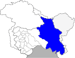
Leh is one of the two districts located in Ladakh, the other being the Kargil District to the west, in the state of Jammu and Kashmir, India. With an area of 45,110 km2, it is the second largest district in the country (after Kutch, Gujarat) in terms of area. It is bounded on the north by Ghanche District (Gilgit-Baltistan), a small border with Xinjiang, China, via the Karakoram Pass which is part of the district. Aksai Chin and Tibet are to the east, Kargil district to the west, and Lahul and Spiti to the south. The district headquarters is based in Leh. It lies between 32 to 36 degree north latitude and 75 to 80 degree east longitude.
The whole of Ladakh was under the administration of Leh until July 1, 1979, when the Kargil and Ladakh administrative districts were created. Religion has been a source of grievances between Buddhists and Muslims since the late 20th century and was a contributor to this division.[1]
As of 2011 it is the second least populous district of Jammu and Kashmir (out of 22), after Kargil.[2]
Demographics
According to the 2011 census Leh district has a population of 147,104,[2] roughly equal to the nation of Saint Lucia.[3] This gives it a ranking of 599th in India (out of a total of 640).[2] The district has a population density of 3 inhabitants per square kilometre (7.8/sq mi) .[2] Its population growth rate over the decade 2001-2011 was 25.48%.[2] Leh has a sex ratio of 583 females for every 1000 males,[2] and a literacy rate of 80.48%.[2]
Religion
According to the 2011 census of India, Leh district had a population of 147,104. Buddhists made up the majority at 66.4%, followed by Hindus at 17.1% and then Muslims at 14.3%.
Administration
Leh is divided into 3 tehsils and 9 blocks.[5] The nine blocks are: Durbuk, Khalsi, Saspol, Kharu, Leh, Chuchot, Nobra, Panamik and Nyoma.[6]
The tehsils and villages are:
Politics
Leh District has two assembly constituencies: Nobra and Leh.[7]
Autonomous Hill Council
Leh District is administered by an elected body known as the Ladakh Autonomous Hill Development Council, Leh. The LAHDC was established in 1995.[8]
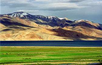 Tsomoriri lake
.jpg) Leh district flower fields and mountains
Leh district flower fields and mountains
References
- ↑ Muslim Precedence Politics - How it operates in Ladakh
- 1 2 3 4 5 6 7 "District Census 2011". Census2011.co.in. 2011. Retrieved 2011-09-30.
- ↑ US Directorate of Intelligence. "Country Comparison:Population". Retrieved 2011-10-01.
Saint Lucia 161,557 July 2011 est.
- ↑ http://www.census2011.co.in/census/district/621-leh.html
- ↑ Leh at a Glance, Ladakh Autonomous Hill Development Council
- ↑ Statement showing the number of blocks in respect of 22 Districts of Jammu and Kashmir State including newly Created Districts dated 2008-03-13, accessed 2008-08-30
- ↑ "ERO's and AERO's". Chief Electoral Officer, Jammu and Kashmir. Retrieved 2008-08-28.
- ↑ http://leh.nic.in/lahdc.htm
External links
| Wikimedia Commons has media related to Leh district. |
- Official Website of Ladakh Autonomous Hill Development Council, Leh
- Ladakh Tourism Guide - Photo Gallery of Leh, Monasteries in Leh, NGO’s in Leh, Important Phone #.
 |
Disputed region | China | | |
| Kargil district | |
China | ||
| ||||
| | ||||
| Lahaul and Spiti district, Himachal Pradesh |
Coordinates: 34°10′00″N 77°35′00″E / 34.1667°N 77.5833°E