List of national parks in Albania
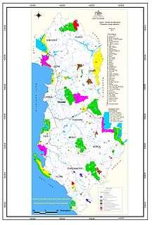
Network of national parks of Albania shown in green color
Albania has 15 national parks covering a surface area of 210,668.48 hectares (2,106.6848 km2) or roughly 13.65% of the overall territory.[1]
The country's most well-known national park, Butrint, was included in UNESCO's list of world heritage sites in 1992. Recently, british newspaper The Guardian in one of its articles named Butrint one of the top 10 must see national parks in Europe.[2]
National parks
| Name | Image | Location | Area | Established | Description |
|---|---|---|---|---|---|
| Butrint |  | Sarandë 39°46′N 20°02′E / 39.76°N 20.03°E | 9,424.4 hectares (94.244 km2) | 1966 | Inhabited since prehistoric times, Butrint has been the site of a Greek colony, a Roman city and a bishopric. Following a period of prosperity under Byzantine administration, then a brief occupation by the Venetians, the city was abandoned in the late Middle Ages after marshes formed in the area. The present archaeological site is a repository of ruins representing each period in the city’s development.[3] |
| Llogara | 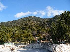 | Vlorë 40°13′N 19°34′E / 40.22°N 19.56°E | 1,010 hectares (10.1 km2) | 1966 | The Park is known for its vibrant flora and fauna with over 100 different types of wild animals and birds including: deer, wild cats, foxes, etc. The mixture of refreshing high altitude mountain air and the proximity to the sea make it a very attractive destination for tourists. The area is also important for the growth of eco-tourism, picnic, hiking and air sports. |
| Karaburun-Sazan | 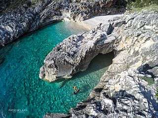 | Vlorë 40°27′N 19°19′E / 40.45°N 19.31°E | 12,428 hectares (124.28 km2) | 2010 | The only marine park in Albania. Consists of surrounding sea water, 1 nautical mile from the shores of the Karaburun Peninsula and Sazan Island. |
| Divjakë-Karavasta | 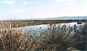 | Divjakë 40°56′N 19°30′E / 40.93°N 19.50°E | 22,230 hectares (222.3 km2) | 2008 | The largest lagoon in Albania and one of the largest in the Adriatic Sea. It is separated from the Adriatic Sea by a large strip of sand. The lagoon is part of the Divjakë-Karavasta National Park. It was chosen as an area of international importance, protected by the Ramsar Convention of 29 November 1995. |
| Mount Dajt | 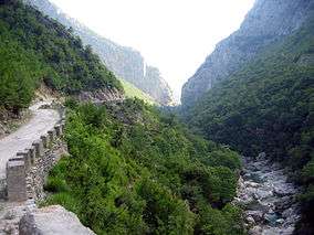 | Tiranë 41°24′N 19°55′E / 41.40°N 19.92°E | 29,384.18 hectares (293.8418 km2) | 1966 | Dajti National Park is located 26 km east of the capital, Tirana. It's accessible all year round and can be reached on foot or via cable cars. |
| Lurë | 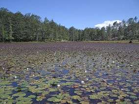 | Dibër 41°46′N 20°11′E / 41.76°N 20.19°E | 1,280 hectares (12.8 km2) | 1966 | This national park is home to many rare species of wildlife. The twelve glacial lakes of Lurë that were formed during the Würm glacial period are an identifying attraction. |
| Lake Prespa |  | Pustec 40°47′N 20°53′E / 40.79°N 20.88°E | 27,750 hectares (277.5 km2) | 1999 | Prespa Lakes are the highest tectonic lakes in the Balkans, standing at an elevation of 853 m (2,798 ft). |
| Theth | 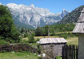 | Shkodër 42°25′N 19°47′E / 42.41°N 19.78°E | 2,630 hectares (26.3 km2) | 1966 | Theth is a national park in the extreme north of the country, designated by government decree in 1966.[4] It covers an area of 2,630 hectares and is located along the Theth River. The main attractions in the park are the Grunas Waterfall and the Lock-in Tower.[4] |
| Valbonë Valley |  | Tropojë 42°26′N 19°56′E / 42.43°N 19.93°E | 8,000 hectares (80 km2) | 1996 | Designated in 1996, the park covers 8,000 hectares including the Valbona Valley and the Valbona River[5] and lies between high and craggy peaks bordering Theth, Gashi River, Plava and Gucia (Montenegro), all strictly protected natural areas. |
| Fir of Hotovë-Dangëlli | 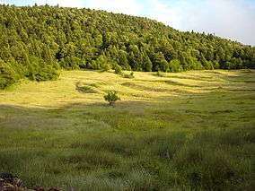 | Përmet 40°18′N 20°24′E / 40.30°N 20.40°E | 34,361.1 hectares (343.611 km2) | 2008 | This park contains the largest area of Bulgarian Fir in the Balkans. Other tree species include maple, black hornbeam, ilex, red and black juniper, raspberry etc. |
| Shebenik-Jabllanicë |  | Librazhd 41°13′N 20°27′E / 41.22°N 20.45°E | 33,927.7 hectares (339.277 km2) | 2008 | The park is one of Albania’s newest, created in 2008. Within the park region dwell a number of different species that are fast becoming rare in Albania, including the brown bear, gray wolf and the endangered Balkan Lynx.[6] |
| Shtamë Pass |  | Krujë 41°31′N 19°53′E / 41.52°N 19.89°E | 2,000 hectares (20 km2) | 1996 | The majority of the park is mostly undeveloped mountain land with forests, in which pine trees, and oak dominate. |
| Fir of Drenova |  | Korçë 40°34′N 20°50′E / 40.57°N 20.83°E | 1,380 hectares (13.8 km2) | 1966 | The park has a particular importance on the trans-boundary exchanges of flora and fauna elements. It represents a key habitat and bio corridor for large vertebrates, such as the bear (Ursus arctos), wolf (Canis lupus), roe deer (Capreolus capreolus); a habitats variety of: natural subalpine and alpine pastures, beech forest (Fagus syvaticus), pine (Pinus sp.), fir (Abies sp.) and hazelnut (Corrilus avellana). |
| Mount Tomorr | .jpg) | Berat 40°42′N 20°08′E / 40.70°N 20.14°E | 24,723.1 hectares (247.231 km2) | 1996 | In the classical period, Mount Tomorr was originally known as Mount Amyron who was a central feature in the region of Dassaretis, which was named after its inhabitants the Dexari, a tribe of Epirus belonging to the Chaonian people.[7] |
| Zall-Gjoçaj | .jpg) | Mat 41°43′N 20°11′E / 41.71°N 20.19°E | 140 hectares (1.4 km2) | 1996 | Zall-Gjoçaj National Park is a wonderful park 40 km northeast of the town of Burrel. Featuring a variety of springs and ravines, it is resplendent in natural beauty. |
Archaeological parks
| Name | Image | Location | Area | Established | Description |
|---|---|---|---|---|---|
| Amantia | .jpg) |
Selenicë 40°13′N 19°25′E / 40.22°N 19.42°E |
15 hectares (0.15 km2) | 2005 | The best preserved monument in the park is the Stadium. First discovered in 1956 by archeologist Skënder Anamali, it is square shaped in the East-West side with a length of 40.40 m and 17 elevated stairs for spectators. |
| Antigonea |  |
Gjirokastër 40°05′N 20°13′E / 40.09°N 20.22°E |
92 hectares (0.92 km2) | 2005 | The city was founded by king Pyrrhus of Epirus in 295 BC. It was named Antigonea in honor of the king's first wife. Antigonea became an important economic and cultural center towards the end of the 3rd century BC. |
| Apollonia | _-_Monument_of_Agonothetes.JPG) |
Fier 40°43′N 19°28′E / 40.72°N 19.47°E |
140 hectares (1.4 km2) | 2006 | Apollonia flourished in the Roman period and was home to a renowned school of philosophy, but began to decline in the 3rd century AD when its harbor started silting up as a result of an earthquake. It was abandoned by the end of the Late Antiquity. |
| Bylis | 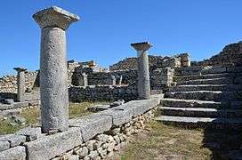 |
Ballsh 40°32′N 19°44′E / 40.54°N 19.73°E |
30 hectares (0.30 km2) | 2005 | This park contains the largest number of archaeological monuments uncovered in Albania. Located on top of a hill near the village of Hekal, Bylis is one of the most important archaeological sites in the country. |
| Lissus |  |
Lezhë 41°47′N 19°39′E / 41.78°N 19.65°E |
22 hectares (0.22 km2) | 2005 | The castle is the main attraction in this park. It rises on top of a hill 305 m high. Its guarding walls belong to the Byzantine period. |
| Oricum |  |
Orikum 40°20′N 19°29′E / 40.33°N 19.48°E |
694 hectares (6.94 km2) | 2005 | The largest archaeological park in the country. It includes the hills of Paleokastra, the necropolis of Sadovinë, the church of Marmiroi, the field of Palloringu and the Lagoon with its port. |
| Phoenice | 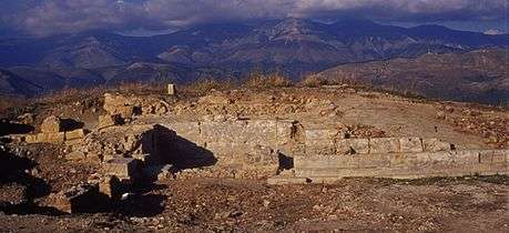 |
Finiq 39°55′N 20°04′E / 39.91°N 20.06°E |
57 hectares (0.57 km2) | 2005 | This ancient city was the capital of the ancient state of Epirus as well as its most fortified city. |
| Shkodër | 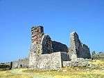 |
Shkodër 42°03′N 19°29′E / 42.05°N 19.49°E |
70 hectares (0.70 km2) | 2005 | Rozafa Castle as the main attraction stands atop a rocky hill in the southeast entrance of the city. It is protected by 9 towers on all sides. |
See also
References
- ↑ Përshkrimi i Rrjetit aktual të zonave të mbrojtura
- ↑ Top 10 national parks in Europe: readers' travel tips
- ↑ http://whc.unesco.org/en/list/570
- 1 2 Thethi-Guide. "Historia e Parkut Kombetar Theth" (in Albanian). Retrieved 28 July 2010.
- ↑ Albanian National Agency of Tourism. "Valbona Valley National Park" (in Albanian). Retrieved 28 July 2010.
- ↑ "Proclamation of the natural ecosystem of Shebenik – Jabllanica as a "National Park"". Cat Specialist Group.
- ↑ Hammond 1994, pp. 422–423; Hammond & Griffith 1972, p. 94.
External links
| Wikimedia Commons has media related to National parks of Albania. |
- Albanian National Parks on Discover Dinarides
- National Agency of Protected Areas of Albania Official Website
- National Coastal Agency of Albania Official Website (Albanian)
- Map of Protected Areas of Albania
- Archaeological Parks of Albania Official Website
- Network of Protected Areas of Albania List
| National | |
|---|---|
| Archaeological | |
| See also | |
This article is issued from Wikipedia - version of the 10/4/2016. The text is available under the Creative Commons Attribution/Share Alike but additional terms may apply for the media files.