Medina Dam
|
Medina Dam | |
|
Medina Dam in 2010 | |
  | |
| Location | Medina County, near Mico, Texas, USA |
|---|---|
| Coordinates | 29°32′25″N 98°56′2″W / 29.54028°N 98.93389°WCoordinates: 29°32′25″N 98°56′2″W / 29.54028°N 98.93389°W |
| Built | 1912 |
| NRHP Reference # | 76002050[1] |
| TSAL # | 468 |
| Significant dates | |
| Added to NRHP | March 15, 1976 |
| Designated TSAL | 5/28/1981 |
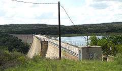
The Medina Dam is a hollow-masonry type dam built in 1911 and 1912 by the Medina Irrigation Company in what became Mico, Texas, USA. Medina Lake extends north of it in northeastern Medina County and southeastern Bandera County. The dam and irrigation project was designed and financed by Dr. Frederick Stark Pearson, an American engineer, with extensive British financial backing. The construction took over 1500 men two years to build while working 24 hours a day. They were mostly skilled Mexican workers with experience building other dams for Pearson. They received two dollars for a day's work. Pearson's Medina Irrigation Company (MICO) built a camp to house the workers and their families; the company town was first called MICO after its acronym. The community is now known as Mico, Texas.
When the dam was completed in 1913, it was the largest hydraulic engineering project west of the Mississippi River and the fourth-largest dam in the US.[2] It is listed on the National Register of Historic Places for its significance as an infrastructure project and its contributions to economic development of the county.
The dam contains over 292,000 cubic yards (223,000 m³) of concrete and measures 164 feet high by 128 feet (39 m) wide at the base by 1,580 feet (482 m) long. It is 25 feet (8 m) wide at the top, which is 1076.2 feet (328 m) above sea level, and the spillway is 1,064.2 feet (324 m) above sea level.[3] The dam provides irrigation to over 34,000 acres (138 km²) to Blackland Prairie farmlands below the Balcones Escarpment around Castroville, Texas, and also supplies water to the Medina River Ultrafiltration Water Treatment Plant owned and operated by the San Antonio Water System.[4]
The reservoir behind the dam is called Medina Lake and is a major recreation area. It discharges into the Medina River, which also contains a diversion dam four miles downstream.
See also
References
- ↑ National Park Service (2006-03-15). "National Register Information System". National Register of Historic Places. National Park Service.
- ↑ Ruben E. Ochoa, "Medina County", Handbook of Texas Online, accessed 3 Aug 2010
- ↑ "USGS 08179500 Medina Lk nr San Antonio, TX". United States Geological Survey. 25 October 2016.
- ↑ "SAWS Water Supply Projects: Medina Lake". San Antonio Water System. Retrieved 25 October 2016.
Further reading
- Cyril Matthew Kuehne, S.M., Ripples from Medina Lake, San Antonio, TX: Naylor, 1966.
- Huffstutler Norton, Rebecca and Karen Downing Ripley, Images of America: Medina Lake, Charleston, SC: Arcadia Publishing, 2012. ISBN 978-0-7385-8547-5

